

|
OLYMPIC National Park |
 |
The Shape of the Land Today
Knowledge of the geological history of an area enables us to better understand the shape of the land today. It will be recalled that earth movements depressed the land on the north, south, and east, leaving the Olympic Mountains standing alone, isolated from other mountains. However, they are a segment of that elongated western fringe of mountains known as the Coast Range. In all that range the Olympics are the highest; yet, for western mountains they are not high, dominating Mount Olympus being only 7,954 feet above sea level. This is not to suggest, however, that the Olympics are small. These mountains have their base at sea level, or not much above, and viewed from any lowland position they appear impressive indeed. A mountain climb will confirm this idea of their size.
There is no single range of mountains in the Olympics, but a profusion of peaks and ridges with intervening valleys—a mountain dome 60 miles across from north to south and east to west, cut by glaciers and numerous streams into rugged peaks and steep-walled valleys. There are nearly a hundred named peaks in Olympic National Park.
Mount Olympus occupies a central position on the Peninsula. To the west the ridges descend gradually and merge with the coastal plain which varies from a few to 20 miles in width. The eastern half of the Olympics maintain a high elevation all the way to the eastern edge. There they drop steeply to Hood Canal, an arm of Puget Sound, leaving but little lowland on that side of the Peninsula. The mountains end abruptly on the north side, too, but with some foothills between them and the shores of Juan de Fuca Strait, some 3 to 6 miles distant. Except for the western slopes, the ridges have a fairly uniform elevation of between 5,000 and 6,000 feet, and the peaks rise 1,000 to 2,000 feet higher.
The Olympic high country shows the effects of glacier scouring everywhere. Numerous lakes lie in basins that were scooped out by the same glaciers that carved circular hollows at the heads of valleys. Slopes sweep upward from the basins with increasing steepness and in many places end in serrated rock ridges and pinnacles. Out of the basins the valleys continue broadened and U-shaped. The larger valleys of the west side—the Hoh, Queets, and Quinault—carry this glaciated U-shape almost to the foot of the mountains.
Some of the mountain valleys have ridges of rock materials on their floors. These are moraines left by the glaciers. Some are end moraines and mark the farthest advance of the ice down the valley. Others represent places where the glaciers halted in their retreat. Most of the end moraines are imperfect, having been cut through and partly destroyed by the flow of water from the melting glaciers.
More than a dozen streams flow out of the Olympic Mountains, returning rain and melt water to the ocean. They drop down steeply from the high level basins; after a few swift miles they flatten out and the water takes a slower pace.
In summary, we may say that Olympic rocks were formed beneath the sea during at least three periods of submergence. Each submergence was followed by a period of uplift when the land was elevated above the sea. Thousands of feet of sedimentary rock with interbedded lava sheets were removed by erosion during millions of years. Valley glaciers and streams have had 20 million years to work on the mountains since their last emergence from the sea; from the interior Olympic mass all but the oldest sediments and lavas have been stripped away. The dense lavas along the outer rim of the mountains on the north, east, and south have resisted erosion more successfully than the softer sediments. Their presence strongly influenced the development of the pattern of ridges and valleys that we see today.
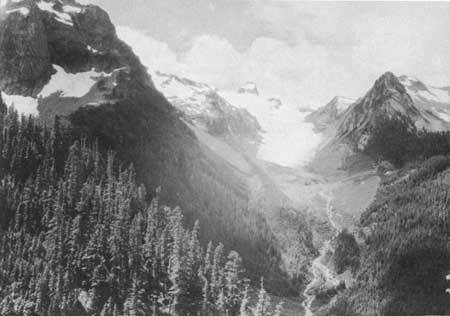 THE GLACIERS WERE ONCE MUCH LARGER. THE SHARP TREE LINE IN THIS PICTURE REPRESENTS A FORMER POSITION OF WHITE GLACIER. |

|

|

| NPS History | History & Culture | National Park Service | Contact |
|
Last Modified: Sat, Nov 4 2006 10:00:00 pm PST |