

|
GLACIER National Park |
 |
 A Divided Climate Because of an eastward flow of cool, moist Pacific air masses, the climate of northwestern Montana, including the western portion of Glacier National Park, differs from that of other portions of Montana. As a result of increased precipitation, Glacier's western valleys support a rich flora, more typical of the Pacific Northwest. As the moisture-laden Pacific winds are pushed up the windward slopes of Glacier's mountains, the air cools and water vapor condenses, forming fog or clouds. Rain or snow begins to fall as the air continues to rise and cool. By the time the air mass reaches the crest and flows down the leeward slopes, most of the moisture has been lost. Western slopes average about 70 cm. of precipitation at elevations between 900 and 1,100 m. Upper elevations average 200 to 250 cm., mostly in the form of snow; and 300 to 500 cm. is common. Eastern slopes, under the influence of Continental air masses, receive less annual precipitation. West Glacier's annual average is 66.5 cm. Babb, a small town east of the park, averages 49.3 cm. Frequent high winds east of the Divide further reduce moisture through evaporation. Exposed to Arctic air masses flowing down from canada, locations east of the Divide also suffer more severe winter conditions than do protected western valleys. Average January temperature is -6° at West Glacier, -8° at Babb. Moreover, 80 percent of the winter days in the western portion of the park are overcast, a condition almost identical to that of Seattle, Wash. This serves to moderate winter temperatures and to minimize evaporation. (click on above image for an enlargement in a new window) |
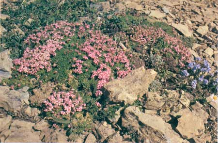 Moss campion and mountain forget-me-not colonize a fellfield. Fellfields are rocky alpine sites that are slightly less than 50% bare rock, interspersed with such plant pioneers as cushion plants, mosses, and lichens. |
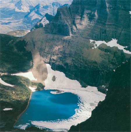 High lakes generally occupy cirque basins. These depressions in the valley bedrock, quarried by glaciers, are deepest near the headwall where ice thickness was greatest, cold and deep, and ice-free only weeks each year, tarns cannot support vascular plants or vertebrates. Iceberg Lake, shut off from the sun most of the year by the encompassing 1,000-meter walls of Mt. wilbur and the Ptarmigan Wall, is never completely free of ice. |

|

|

| NPS History | History & Culture | National Park Service | Contact |
|
Last Modified: Sat, Nov 4 2006 10:00:00 pm PST |