|
MOUNT RAINIER
Mount Rainier and Its Glaciers |

|
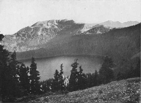
MOWICH LAKE AND THE EMPTY CIRQUES AT THE MOUNTAIN'S FOOT.
West of the profound canyon of the Carbon River, there rises a craggy range which the Indians have named the Mother Mountains. (Fig. 16.) From its narrow backbone one looks down on either side into broadly open, semicircular valley heads. Some drain northward to the Carbon River, some southward to the Mowich River. Encircling them run attenuated rock partitions, surmounted by low, angular peaks; while cutting across their stairwise descending floors are precipitous steps of rock, a hundred feet in height. On the treads lie scattered shallow lakelets, strung together by little silvery brooks trickling in capricious courses.
Most impressive is the basin that lies immediately under the west end of the range. Smoothly rounded like a bowl, it holds in its center an almost circular lake of vivid emerald hue—that mysterious body of water, Mowich Lake, formerly known as Crater Lake. (Fig. 18.) The former appellation was an unfortunate misnomer as the basin is not of volcanic origin. It lies in lava and other volcanic rocks, to be sure, but these are merely spreading layers of the cone of Mount Rainier. Ice is the agent responsible for the carving of the hollow. It was once the cradle of a glacier, and that ice mass, gnawing headward and deploying even as the Carbon Glacier does to-day, enlarged its site into a horseshoe basin, a typical glacial cirque. The lake in the center is a strictly normal feature; many glacial cirques possess such bowls, scooped out by the eroding ice masses from the weaker portions of the rock floor; only it is seldom that such features acquire the symmetry of form exhibited by Mowich Lake. The lakelets observed in the neighboring valley heads—all of which are abandoned cirques—are of similar origin.
|
| FIG. 18.—MOWICH LAKE, A GLACIER BASIN IN THE BOSOM OF AN ABANDONED "CIRQUE." THE FEATURE IS NOT OF VOLCANIC ORIGIN, AS WAS ONCE SUPPOSED. Photo by Barnes. |
As for the skeleton character of the dividing crests, it will be readily seen to be the outcome of the headward gnawing of opposing cirques. In some places, even, the deploying process has attenuated the ridges sufficiently to break them through. West of Mowich Lake is an instance of a crest that has thus been breached.
It is a significant fact that the empty cirques about the Mother Mountains lie at elevations ranging between 4,500 and 6,000 feet; that is, on an average 5,000 feet lower than the cirques on Mount Rainier which now produce glaciers. Evidently the snow line in glacial times lay at a much lower level than it does to-day, and the ice mantle of Mount Rainier expanded not merely by the forward lengthening of its ice tongues but by the birth of numerous new glaciers about the mountain's foot. The large size of the empty cirques and canyons, moreover, leads one to infer that many of these new glaciers far exceeded in volume the ice streams descending the volcano's sides. The latter, it is true, increased considerably in thickness during glacial times, but not in proportion to the growth of the low-level glaciers. Nor is this surprising in view of the heavy snowfalls occurring on the mountain's lower slopes. There is good reason to believe, moreover, that the cool glacial climate resulted in a general lowering of the zone of heaviest snowfall. It probably was depressed to levels between 4,000 and 6,000 feet. Not only the cirque glaciers about the Mother Mountains, but all the neighboring ice streams of the glacial epoch originated within this zone, as is indicated by the altitudes of the cirques throughout the adjoining portions of the Cascade Range. By their confluence these ice bodies produced a great system of glaciers that filled all the valleys of this mountain belt and even protruded beyond its western front.

|
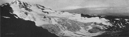
| FIG. 19.—THE NORTHWEST SIDE OF MOUNT RAINIER AND SPRAY PARK, VIEWED FROM THE MOTHER MOUNTAIN. THE SHARP WHITE SUMMIT IN LIBERTY CAP (14,112 FEET). Copyrighted photo by Curtis. |
To these extensive valley glaciers the ice flows of Mount Rainier stood in the relation of mere tributaries. They descended from regions of rather scant snowfall, for the peak in those days of frigid climate rose some 10,000 feet above the zone of heaviest snowfall, into atmospheric strata of relative dryness. It may well be, indeed, that it carried then but little more snow upon its summit than it does to-day.
NORTH MOWICH GLACIER.
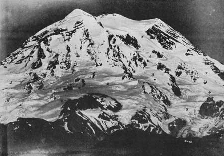
The North Mowich Glacier is the northernmost of the series of ice bodies on the west flank of Mount Rainier. (Figs. 20 and 21.) Like the Carbon Glacier, it heads in a cirque at the base of the Liberty Cap massif, fed by direct snow precipitation, by wind drifting, and by avalanches. The cirque is small and shallow, not as capacious even as either of the twin recesses in the Carbon Glacier's amphitheater. As a consequence the ice stream issuing from it is of only moderate volume; nevertheless it attains a length of 3-3/4 miles. This is due in part to the heavy snows that reenforce it throughout its middle course and in part to overflows from the ice fields bordering it on the south. These ice fields, almost extensive enough to be considered a distinct glacier, are separated from the North Mowich Glacier only by a row of pinnacles, the remnants evidently of a narrow rock partition or "cleaver," now demolished by the ice. The lowest and most prominent of the rock spires bears the appropriate name of "Needle Rock" (7,575 feet).
|
| FIG. 20. THE NORTH MOWICH GLACIER AND THE ICE FIELDS TO THE SOUTH OF IT. Copyrighted photo by Curtis. |
The débris-covered lower end of the glacier splits into two short lobes on a rounded boss in the middle of the channel, This boss, but a short time ago, was overridden by the glacier and then undoubtedly gave rise to an ice dome of the kind so numerous farther up on the North Mowich Glacier and also characteristic of the Winthrop Glacier.
SOUTH MOWICH GLACIER.
Separated from the ice fields of the North Mowich Glacier by a great triangular ice field (named Edmunds Glacier) lies the South Mowich Glacier, also a cirque-born ice stream, heading against the base of the Liberty Cap massif. (Fig. 21.) It is the shortest of the western glaciers, measuring only a scant 3 miles. Aside from the snows accumulating in its ill-shaped cirque it receives strong reenforcements from its neighbor to the south—the Puyallup Glacier.
|
| FIG. 21. TELEPHOTO VIEW OF WEST SIDE OF MOUNT RAINIER, TAKEN FROM ELECTRON, AT A DISTANCE OF 20 MILES. THE MAIN SUMMIT, COMPOSED OF TWO NEW CINDER CONES (14,408 FEET) IS SEEN IN THE CENTER. TO THE LEFT IS LIBERTY CAP (14,112 FEET), AND TO THE RIGHT IS POINT SUCCESS (14,150 FEET), BOTH REMNANTS OF THE OLD CRATER RIM. THE GLACIERS IN THE VIEW ARE 1, NORTH MOWICH; 2, EDMUNDS; 3, SOUTH MOWICH; 4, PUYALLUP; 5, TAHOMA. Photo by Curtis. |
Toward its lower end it splits into two unequal lobes, the southern most of which is by far the longer. Sharp cut rock wedges beyond its front show that when the glacier extended farther down it split again and again.
The north lobe is of interest because the stream that cascades from the Edmunds Glacier runs for a considerable distance under it. In the near future the lobe is likely to recede sufficiently to enable the torrent to pass unhindered by its front.
| <<< Previous | <<< Contents>>> | Next >>> |
matthes/sec7.htm
Last Updated: 07-May-2007