|
MOUNT RAINIER
Mount Rainier and Its Glaciers |

|
NISQUALLY GLACIER.
THE LOWER END.
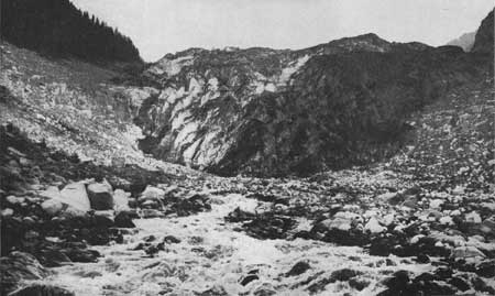
The first ice one meets on approaching the mountain from Longmire Springs lies in the upper end of the Nisqually Valley. The automobile road, which up to this point follows the west side of the valley, winding in loops and curves along the heavily wooded mountain flank, here ventures out upon the rough boulder bed of the Nisqually River and crosses the foaming torrent on a picturesque wooden bridge. Some fifteen hundred feet above this structure, blocking the valley to a height of some 400 feet, looms a huge shapeless pile of what seems at first sight only rock débris, gray and chocolate in color. (Fig. 5.) It is the dirt-stained end of one of the largest glaciers—the Nisqually. From a yawning cave in its front issues the Nisqually stream, a river full fledged from the start.
|
| FIG. 5.—THE DYING LOWER END OF THE NISQUALLY GLACIER, SEEN FROM THE BRIDGE ON THE AUTOMOBILE ROAD TO PARADISE PARK. THE COLOR OF THE ICE IS OBSCURED BY ROCK DÉBRIS. Photo by Barnes. |
The altitude here, it should be noted, is a trifle under 4,000 feet (elevation of bridge is 3,908 feet); hence the ice in view lies more than 10,000 feet below the summit of the mountain, the place of its origin. And in this statement is strikingly summed up the whole nature and economy of a glacier such as the Nisqually.
A glacier is not a mere stationary blanket of snow and ice clinging inert to the mountain flank. It is a slowly moving streamlike body that descends by virtue of its own weight. The upper parts are continually being replenished by fresh snowfalls, which at those high altitudes do not entirely melt away in summer; while the lower end, projecting as it does below the snow line, loses annually more by melting than it receives by precipitation, and is maintained only by the continued accession of masses from above. The rate at which the ice advances has been determined by Prof. J. N. Le Conte, of the University of California. In 1903 he placed a row of stakes across the glacier, and with the aid of surveying instruments obtained accurate measurements of the distances through which they moved from day to day. He found that in summer, when the movement is greatest, it averages 16 inches per day. This figure, however, applies only to the central portion of the glacier—the main current, so to speak—for the margins necessarily move more slowly, being retarded by friction against the channel sides.
The foot of the Nisqually Glacier, accordingly, is really composed of slowly advancing ice, but so rapid is the melting at this low altitude that it effectually counterbalances the advance, and thus the ice front remains essentially stationary and apparently fixed in place. Actually, it is subject to slight back and forward movements, amounting to a foot or more per day; for, as one may readily imagine, fluctuations in snowfall and in temperature, above or below the normal, are ever likely to throw the balance one way or another.
A glacier may also make periodic advances or retreats on a larger scale in obedience to climatic changes extending over many years. Thus all the glaciers on Mount Rainier, as well as many in other parts of the world, are at present, and have been for some time, steadily retreating as the result of milder climate or of a lessening in snow supply. Only so recently as 1885 the Nisqually Glacier reached down to the place now occupied by the bridge, and it is safe to say that at that time no engineer would have had the daring to plan the road as it is now laid. In the last 35 years, however, the Nisqually Glacier has retreated fully 1,500 feet.
Evidences of similar wholesale recession are to be observed at the ends of the other glaciers of Mount Rainier, but the measure of their retreat is not recorded with the precision that was possible in the case of the Nisqually Glacier.
THE LOWER COURSE.
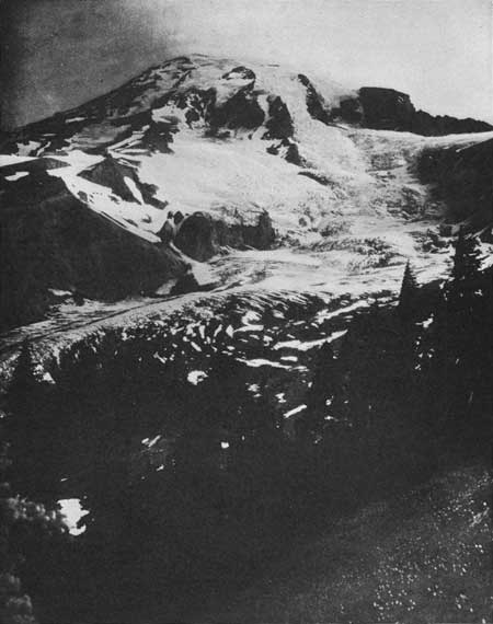
As one continues the ascent by the automobile road a part of the glacier's lower course comes into view, and one gains some idea of its stream-like character. More satisfying are the views from Paradise Park. (Fig. 6.) Here several miles of the ice stream (its total length is nearly 5 miles) lie stretched out at one's feet, while looking up toward the mountain one beholds the tributary ice fields and ice streams, pouring, as it were, from above, from right and left, rent by innumerable crevasses and resembling foaming cascades suddenly crystallized in place. The turmoil of these upper branches may be too confusing to be studied with profit, but the more placid lower course presents a favorable field for observation, and a readily accessible one at that.
|
| FIG. 6.—GENERAL VIEW OF NISQUALLY GLACIER FROM THE HEIGHTS OF PARADISE PARK. THE SQUARE-CUT ROCK MASS TO THE RIGHT OF THE SUMMIT IS GIBRALTAR ROCK, THE CHIEF OBSTACLE IN THE ASCENT OF THE PEAK. Photo by Curtis. |
A veritable frozen river it seems, flowing between smooth, parallel banks, half a mile apart. Its surface, in contrast to the glistening lee cascades above, has the prevailingly somber tint of old ice, relieved here and there by bright patches of last winter's snow. These lie for the most part in gaping fissures or crevasses that run athwart the glacier at short intervals and divide its body into narrow slices. In the upper course, where the glacier overrides obstacles in its bed, the crevasses are particularly numerous and irregularly spaced, sometimes occurring in two sets intersecting at right angles, and cutting the ice into huge square prisms. Farther down the ice stream's current is more sluggish and the crevasses heal up by degrees, producing a united surface, over which one may travel freely.
Gradually, also, the glacier covers itself with débris. Angular rock fragments, large and small, and quantities of dust, derived from the rock walls bordering the ice stream higher up, litter its surface and hide the color of the ice. At first only a narrow ridge of such material—a moraine, as it is called—accompanies the ice river on each side, resembling a sharp-crested embankment built by human hands to restrain its floods; but toward the lower end of the glacier, as the ice wastes away, the débris contained in it is released in masses, and forms brown marginal bands, fringing the moraines. In fact, from here on down it becomes difficult to tell where the ice of the glacier ends at the sides and where the moraines begin.
The lower part of the glacier also possesses a peculiar feature in the form of a débris ridge about midway on its back—a medial moraine. Most of the way it stretches like a slender, dark ribbon, gradually narrowing upstream. One may trace it with the eye up to its point of origin, the junction of the two main branches of the glacier, at the foot of a sharp rock spur on the mountain's flank.
In the last mile of the Nisqually's course, this medial moraine develops from a mere dirt band to a conspicuous embankment, projecting 40 feet above the ice. Not the entire body of the ridge, however, is made up of rock débris. The feature owes its elevation chiefly to the protective influence of the débris layer on its surface, which is thick enough to shield the ice beneath from the hot rays of the sun, and greatly retards melting, while the adjoining unprotected ice surfaces are rapidly reduced.
A short distance above the glacier's terminus the medial moraine and the ever-broadening marginal bands come together. No more clear ice remains exposed, irregular mounds and ridges of débris cover the entire surface of the glacier, and the moraine-smothered mass assumes the peculiar inchoate appearance that is so striking upon first view.
THE UPPER NÉVÉS.
In utter contrast with the glacier's dying lower end are the bright snow fields on the summit in which it commences its career. Hard by the rock rim of the east summit crater the snows begin, enwrapping in an even, immaculate layer the smooth sides of the cinder cone. Only a few feet deep at first, they thicken downward by degrees, until, a thousand feet below the crater, they possess sufficient depth and weight to acquire movement. Occasional angular crevasses here interrupt the slope and force the summit-bound traveler to make wearying detours.
Looking down into a gash of this sort one beholds nothing but clean snow, piled in many layers. Only a faint blue tinges the crevasse walls, darkening but slowly with the depth, in contrast to the intense indigo hue characteristic of the partings in the lower course of the glacier. There the material is a dense ice, more or less crystalline in texture; here it is scarcely more than snow, but slightly compacted and loosely granular—what is generally designated by the Swiss term "névé."
For several thousand feet down, as far as the 10,000-foot level, in fact, does the snow retain this granular consistency. One reason for the slowness with which it compacts is found in the low temperatures that prevail at high altitudes and preclude any considerable melting. The air itself seldom rises above the freezing point, even in the middle of the day, and as a consequence the snow never becomes soft and mushy, as it does at lower levels.
When snow assumes the mushy, "wet-sugar" state, it is melting internally as well as at its outer surface, owing both to the water that soaks into it and to the warming of the air inclosed within its innumerable tiny pores (which tiny air spaces, by the way, give the snow its brilliant whiteness). Snow, in this condition has, paradoxical though it may sound, a temperature a few tenths of a degree higher than the melting point—a fact recently established by delicate temperature measurements made on European glaciers. It is this singular fact, no doubt, that explains how so many minute organisms are able to flourish and propagate in summer on the lower portions of many glaciers. It may be of interest to digress here briefly in order to speak of these little known though common forms of life.
FAUNA AND FLORA OF GLACIERS.
Several species of insects are among the regular inhabitants of glaciers. Most of them belong to a very low order—the Springtails, or Thysanura—and are so minute that in spite of their dark color they escape the attention of most passers-by. If one looks closely, however, they may readily be observed hopping about like miniature fleas or wriggling deftly into the cavities of the snow. It seems to incommode them but little if in their acrobatic jumps they occasionally alight in a puddle or in a rill, for they are thickly clad with furry scales that prevent them from getting wet—just as a duck is kept dry by its greasy feathers.
Especially plentiful on the lower parts of the Rainier glaciers, and more readily recognized, are slender dark-brown worms of the genus Mesencytraeus, about 1 inch in length. Millions and millions of them may be seen on favorable days in July and August writhing on the surface of the ice, evidently breeding there and feeding on organic matter blown upon the glacier in the form of dust. So essential to their existence is the chill of the ice that they enter several inches, and sometimes many feet below the surface on days when the sun is particularly hot, reappearing late in the afternoon.
Mention also deserves to be made of that microscopic plant Protococcus nivalis, which is responsible for the mysterious pink or light, rose-colored patches so often met with on glaciers—the "red snow" of a former superstition. Each patch represents a colony or culture comprising billions of individuals. It is probable that they represent but a small fraction of the total microflora thriving on the snow, the other species remaining invisible for lack of a conspicuous color.
SNOW CUPS AND HONEYCOMBS.
To return to the frigid upper névés, it is not to be supposed that they suffer no loss whatever by melting. The heat radiated directly to them by the sun is capable of doing considerable damage, even while the air remains below the freezing point. At these high altitudes the sun heat is astonishingly intense, as more than one uninitiated mountain climber has learned to his sorrow by neglecting to take the customary precaution of "painting" his face before making the ascent. In a few hours the skin is literally scorched and begins to blister painfully.
At the foot of the mountain the sun heat is relatively feeble, for much of it is absorbed by the dust and vapor in the lower layers of the atmosphere, but on the summit, which projects 2 miles higher, the air is thin and pure, and lets the rays pass through but little diminished in strength.
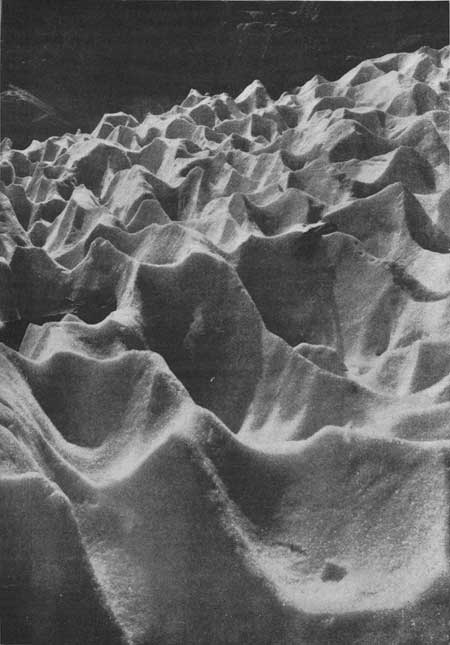
The manner in which the sun affects the snow is peculiar and distinctive. Instead of reducing the surface evenly, it melts out many close-set cups and hollows, a foot or more in diameter and separated by sharp spires and crests. No water is visible anywhere, either in rills or in pools, evaporation keeping pace with the reduction. If the sun's action is permitted to continue uninterrupted for many days, as may happen in a hot, dry summer, these snow cups deepen by degrees, until at length they assume the aspect of gigantic bee cells, several feet in depth. (Fig. 7.) Snow fields thus honeycombed are often met with on the slopes above Gibraltar Rock. They are wearisome to traverse, for the ridges and spines are fairly resistant, so that one must laboriously clamber over them. Most exasperating, however, is the going after a snowstorm has filled the honeycombs. Then the traveler, waist deep in mealy snow, is left to flounder haphazard through a hidden labyrinth.
|
| FIG. 7.—SNOW CUPS AND "HONEYCOMBS" PRODUCED IN A HIGH NÉVÉ FIELD BY THE HOT RAYS OF THE SUN. THE AIR AT THESE HEIGHTS REMAINS ALMOST CONSTANTLY BELOW THE FREEZING POINT. Photo by G. K. Gilbert. |
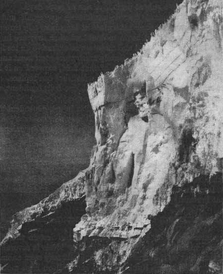
Of interest in this connection is the great snow cliff immediately west of Gibraltar Rock. (Fig. 8.) Viewed from the foot of that promontory, the sky line of the snow castle fairly bristles with honeycomb spines; while below, in the face of the snow cliff, dark, wavy lines, roughly parallel to the upper surface, repeat its pattern in subdued form. They represent the honeycombs of previous seasons, now buried under many feet of snow, but still traceable by the dust that was imprisoned with them.
|
| FIG. 8.—THE SNOW CLIFF WEST OF GIBRALTAR ROCK. THE SPINES ON THE SKY LINE PROJECT FROM BETWEEN DEEP "HONEYCOMBS." THE WAVY LINES IN THE FACE OF THE CLIFF INDICATE HONEYCOMBED SURFACES OF FORMER SEASONS, BURIED UNDER THE SNOWS OF SUCCESSIVE WINTERS. Photo copyrighted by Barnes. |
ICE CASCADES.
The snow cliff west of Gibraltar Rock is of interest also for other reasons. It is the end of a great snow cascade that descends from the rim of the old crater. Several such cascades may be seen on the south side of the mountain, separated by craggy remnants of the crater rim. Above them the summit névés stretch in continuous fields, but from the rim on down, the volcano's slopes are too precipitous to permit a gradual descent, and the névés break into wild cascades and falls. Fully two to three thousand feet they tumble, assembling again in compact, sluggish ice fields on the gentler slopes below.
Of the three cascades that feed the Nisqually Glacier only the Central one, it is to be observed, forms a continuous connection between the summit névés and the lower ice fields. (Fig. 6.) The two others, viz, the one next to Gibraltar and the westernmost of the three, terminate in vertical cliffs, over great precipices of rock. From them snow masses detach at intervals and produce thundering avalanches that bound far out over the inclined ice fields below. Especially frequent are the falls from the cliff near Gibraltar. They occur hourly at certain times but as a rule at periods of one or more days.
From the westernmost cascade avalanches are small and rare. Indeed, as one watches them take place at long intervals throughout a summer one can not but begin to doubt whether they are in themselves really sufficient to feed and maintain so extensive an ice field as lies stretched out under them. Surely much more snow must annually melt away from the broad surface of that field, exposed as it lies to the midday sun, than the insignificant avalanches can replace. Were they its only source of supply, the ice field, one feels confident, would soon cease to exist.
The fact is that the ice field in question is not dependent for its support on the avalanches from above. It may receive some contributions to its volume through them, but in reality it is an independent ice body, nourished chiefly by direct snow precipitation from the clouds. And this is true, in large measure, of all the ice fields lying under the ice cascades. The Nisqually Glacier, accordingly, is not to be regarded as composed merely of the cascading névés, reunited and cemented together, but as taking a fresh start at these lower levels. Improbable though this may seem at first, it is nevertheless a fact that is readily explained.
DISTRIBUTION OF SNOWFALL ON MOUNT RAINIER.
The winter snows on Mount Rainier are heaviest in the vicinity of its base; indeed, the snowfall at those low levels is several times greater than that on the summit. This in itself may seem anomalous. So accustomed is one to think that the snowfall on high mountains increases with the altitude that it seems strange to find a case in which the opposite is true. Yet Mount Rainier stands by no means alone in this regard. The Sierra Nevada and the Andes, the Himalayas and the Alps, all show closely analogous conditions.
In each of these lofty mountain regions the precipitation is known to be heaviest at moderate altitudes, while higher up it decreases markedly. The reason is that the storm clouds—the clouds that carry most of the rain and snow—hang in a zone of only moderate elevation, while higher up the atmosphere contains but little moisture and seldom forms clouds of any great density.
In the Rainier region the height of the storm clouds is in large measure regulated by the height of the Cascade Range; for it is really this cooling mountain barrier that compels the moisture-laden winds from the Pacific Ocean to condense and to discharge. It follows that the storm clouds are seldom much elevated above the sky line of the Cascade Mountains; they cling, so to speak, to its crests and ridges, while the cone of Mount Rainier towers high above them into serener skies. Many a day one may look down from the summit, or even from a halfway point, such as Camp Muir (10,062 feet), upon the upper surface of the clouds. Like a layer of fleecy cotton they appear, smothering the lower mountains and enveloping the volcano's base.
Clouds, it is true, are frequently seen gathering about the mountain's crown, usually in the form of a circular cap or hood, precursor of a general storm, but such clouds yield but very little snow.
No accurate measurements have been made of the snowfall at the mountain's foot, but in the Nisqually Valley, at Longmire Springs, the snow often reaches a depth of 7 feet, and the total snowfall in winter may exceed 20 feet in depth. The summer heat at this low level (2,762 feet) is, of course, abundantly able to remove all of it, at least by the end of May. But higher up every thousand feet of elevation suffices to prolong appreciably the life of the snowy cover. In Paradise Park, for instance, at altitudes between 5,000 and 6,000 feet, huge snowdrifts encumber the flowering meadows until far into July. Above an altitude of 6,000 feet permanent drifts and snow fields survive in certain favored spots, while at the 7,000-foot level the snow line, properly speaking, is reached. Above this line considerable snow remains regularly from one winter to the next, and extensive ice fields and glaciers exist without any protection from the sun.
It is between the 8,000 and 10,000 foot levels, however, that one meets with the conditions most favorable for the development of glaciers. Below this zone the summer heat largely offsets the heavy precipitation, while above it the snowfall itself is relatively scant. Within the belt the annual addition of snow to the ice fields is greater than anywhere else on Mount Rainier. The result is manifest in the arrangement and distribution of the glaciers on the cone. By far the greater number originate in the vicinity of the 10,000-foot level, while those ice streams which cascade from the summit, such as the Nisqually, are in a sense reborn some 4,000 feet lower down.
| <<< Previous | <<< Contents>>> | Next >>> |
matthes/sec1.htm
Last Updated: 07-May-2007