Environment, Prehistory & Archaeology of Mount Rainier National Park, Washington
Greg C. Burtchard
FOREWORD TO THE 2003 EDITION
Environment, Prehistory and Archaeology of Mount Rainier National Park is the park's most comprehensive archaeological overview and research design. Based on the results of field and archival research through 1997, it draws together the park's known prehistoric archaeological record, and evaluates it in light of its place within broader regional subsistence and settlement patterns. The 2003 edition remains unchanged except for this foreword, use of color graphics where available, addition of Appendix C containing an otherwise hard-to-get citation in support of ecological arguments made in the body of the text, minor editorial corrections, and production in both paper and compact disk (CD) format.
As the following Preface notes, two historical sites, 20 prehistoric sites and 18 prehistoric isolated finds were documented within park boundaries when the original report was written. These totals account for data available during the overview's preparation period. Text and tabular information included in this reprinted volume is limited to this earlier record. Subsequent archaeological surveys and tests by park service archaeologists, and by Central Washington University's archaeological field school, have increased the site inventory; thereby enhancing our understanding of site age, content, and stratigraphy. At the beginning of 2003, Mount Rainier's archaeological inventory stands at 40 prehistoric and multi-component sites, 29 prehistoric isolated finds, and 31 historical sites and isolates. Firmly dated cultural deposits document human use of Mount Rainier to 3,500 radiocarbon years ago. Test results from two open sites and two rockshelter sites have revealed surprisingly high densities of lithic debris, suggesting repeated use of park landscapes since at least that time. Stratigraphic sequences from Sunrise Ridge in the park's northeastern quadrant indicate the presence of a glacier-free, wooded environment at 6,400 feet by 8,500 years ago. Results of these ongoing studies will be made available as separate technical reports as they are completed. Preliminary results tend to support this overview's findings, and suggest a substantial human presence on the mountain dating to at least the mid-Holocene as indicated by the available radiocarbon record, and very likely to the early Holocene as indicated in stratigraphic profiles.
It is important to note that doubling the size of the park's prehistoric site inventory has not changed basic site location or site type patterns emphasized in this overview. As with the original data, a preponderance of prehistoric sites and isolates are found in subalpine habitats: fifty-one (74%) of the current total are located in patchy subalpine parklands, eleven (16%) in alpine settings, and seven (10%) in montane forest contexts–most near the upper elevation forest/subalpine ecotone. No sites have been documented on Mount Rainier's high energy floodplains. In this report, I suggest that the relatively high site count in subalpine to alpine settings reflects focused use of those habitats due to the relatively high abundance of economically useful plant animal species that tend to aggregate there during the summer season. The reality of the pattern and, in my opinion, the basic reasons underlying it have only grown stronger in the intervening years.
Because it has attracted interest and generated much discussion, the notion that prehistoric people directed their activities preferentially toward high elevation subalpine habitats, rather than to lower, more densely forested settings, warrants clarification. In making this argument, it should be noted, that even under the best conditions, archaeological remains are difficult to find on Mount Rainier. Lithic artifacts tend to be small and are obscured by the park's multiple volcanic deposits. They are even more difficult to locate in heavily wooded settings. There is little doubt that the subalpine versus forest pattern reflects, in part, differences in site discovery potential between different vegetation regimes. That said, I am convinced that Mount Rainier site location patterning reflects genuine variation in resource potential, human use patterns, and the archaeological record of that use during the prehistoric past. This is not to say that lower elevation, forested landscapes were avoided altogether; but rather that 1) subalpine and alpine environments constitute the largest expanse of naturally maintained, productive, early seral-stage habitat available within park boundaries; and that 2) in the absence of productive low-elevation salmon bearing streams, these environments were sought out and maintained because of their high resource potential relative to the lower, but more resource-impoverished, wet maritime forests.
Mount Rainier's prehistoric site distribution model, temporal land-use model, and other issues germane to long-term use of high-elevation Cascade landscapes are developed at several points in the body of the text (see, for example, pages 15-16, 44-50, and summary discussion on pages 158-172). Much of the ecological argument included in these discussions, and especially that relevant to site distribution, is built on site location patterns first recognized in an earlier study for Mount Hood National Forest in the northern Oregon Cascades; and refined further through discussions with archaeologists such as Randall Schalk and Bob Mierendorf, who had prepared earlier overviews that modeled human use of high-elevation landscapes in Olympic National Park and North Cascade National Park Complex respectively. In both the Mount Hood report and the present report, I couch arguments relevant to variation in edible resource potential in terms of relative forest maturity. In retrospect, I believe that points would have been better made, and more easily applied to a wider variety of environmental circumstances, if I had referred to differences in seral-stage productivity as summarized above, rather than using the more restrictive and ambiguously interpretable ecosystem maturity concept. Resulting expectations for Mount Rainier, however, are identical. Readers wishing to delve more deeply into the ecological basis for variation in resource productivity, and ultimately site density, in montane habitats may wish to refer to Appendix C which has been added to this printing. Appendix C provides relevant text from the Mount Hood report that was referenced in the original version, but was difficult for many readers to locate.
Prehistoric sites and site types also warrant brief discussion. A prehistoric archaeological site at Mount Rainier, as well as at North Cascades and Olympic National Parks, is identified by the presence of two or more artifacts or features co-occurring within 50 meters or less on the same landform (reduced from the three artifact minimum employed when this report originally was written). The number is low compared to definitions typically employed by archaeologists working in arid lands or where mineral soil visibility is high, but it is one that fairly reflects sustained use of the landscape in this environment. Because knappable stone sources are rare at Mount Rainier, tool kits tended to be highly curated and characterized by late-stage manufacture, resulting in low density assemblages with a high fraction of small, difficult to see, artifacts. Furthermore, use was dominated by small, mobile groups with relatively short-duration stays as reflected in the site type model presented in the body of the text. These factors, combined with the park's active depositional landscape and heavy vegetation, limit the count of artifacts observable through normal surface survey techniques. More recent sub-surface reconnaissance and site testing procedures using fine screen techniques have demonstrated that these sites typically are associated with a higher density of sub-surface remains than would be expected on the basis of surface evidence alone. Failure to record low surface density assemblages as archaeological sites would effectively preclude protection of these sites, as well as meaningful study of long-term human use of the mountain.
Finally, I encourage interested readers to go beyond park-specific information and consider wider implications of the environmental model presented in Chapter 2, the Holocene land-use intensification model offered in Chapter 5, and site type and distribution patterns presented throughout. Importantly, I urge readers to consider the place of Mount Rainier within its regional context and the long sweep of time that humans have lived in its shadow. The mountain does not stand apart from river valleys, prairies, and drier foothill and basin settings that surround it, but rather fits into a complex pattern of land-use strategies that vary in broadly predictable ways across space and through time. I hope that this report assists those who seek a greater understanding of the long history of Mount Rainier and its indigenous inhabitants.
|
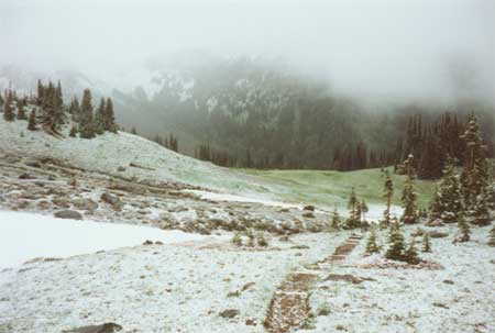
| Subalpine parkland at "Summerland" looking northwest into Fryingpan Creek drainage during an August 16, 1995 snowstorm. Because they afforded access to upper elevation resources, moderated distance to lowland residence and provided relief from unpredictable severe weather, base camps in forest/subalpine ecotonal settings may have been an important element of prehistoric use of Mount Rainier. Fryingpan Rockshelter (45PI43) is situated near Fryingpan Creek below the snowline at photo right. |
| <<< Previous | <<< Contents >>> | Next >>> |