Environment, Prehistory & Archaeology of Mount Rainier National Park, Washington
Greg C. Burtchard
Chapter 6:
MOUNT RAINIER ARCHAEOLOGY MANAGEMENT, RESEARCH & INTERPRETATION
(continued)
MOUNT RAINIER PREHISTORIC
SUMMARY
Chapter 2 concluded with a set of general questions about prehistoric use and the archaeological record on Mount Rainier. Those questions were posed to help clarify the relevance the report's ecological research focus and to anticipate long-term subsistence and settlement patterns contributing to development of the Park's archeological record. Here, we return to these questions to summarize land-use and archaeological issues discussed at greater length in the report. Accompanying each question category is a consideration of the current status of relevant Mount Rainier data and recommendations to improve our understanding of that aspect of the Park's archaeological record.
Why Did Hunter-Gatherers Use Mount
Rainier?
In essence, the question calls for clarification of variables that would have attracted humans to Mount Rainier in sufficient numbers and over a long enough period of time to create its archaeological record. Indeed, this may be the most critical of the four sets of questions posed in that basic causes underlying human use of Mount Rainier strongly influence other montane land-use issues such as onset of earliest use, seasonality, landscapes selected for use and so on.
This report has relied on ecological and economic arguments, in concert with archaeological data, to suggest that the most important "attractors" to Mount Rainier were a limited suite of animals and plants critically important to forager and, to a lesser extent, collector economies. Foremost among these were elk, deer, goats and sheep, marmots and pika, bear, ptarmigan and grouse, and huckleberries. Importantly, all of these food resources tend to co-occur in greatest abundance in areas of reduced forest maturity; that is, in areas with grassy to brushy vegetation and only limited forest cover. On Mount Rainier and in the southern Washington Cascades the largest and most predicable places where these habitat requirements are met are in subalpine and alpine zones above 5,000 ft.
Because of extensive land mass above 5,000 to 6,000 ft, the southern Washington Cascades and particularly Mount Rainier, are capable of sustaining substantial populations of economically useful animals and plants during the brief mountain summer. The contrast is particularly sharp relative to generally resource poor qualities of mature Pacific maritime forests that dominate lower elevation landscapes. Because of these resource qualities, early to mid-Holocene foragers are expected to have been attracted to Mount Rainier's upper elevation landscapes as part of a normal mobile residential round. Later in the Holocene, in a context of elevated population density and resource competition, resource emphases shifted to salmon and other storable resources by collectors residing in larger, more nearly sedentary villages with more complex resource capture and distribution mechanisms. Use of the mountain is expected to have continued in order to protect remaining ungulate herds and to exploit alternative high return resources such as goats and (in the very late Holocene) huckleberries not readily available in lowlands settings.
Mount Rainier Data
Mount Rainier's extant archaeological record is strongly consistent with hunting-related use of subalpine and alpine settings on all sides of the mountain. Hunting is suggested by the suite of hafted biface, butchering tools and lithic debitage that make up the bulk of the current sample of observed and collected artifacts. Plant processing locations have yet to be documented in Mount Rainier. It is possible, however, that reported, but presently undocumented, peeled cedar locations may be associated with manufacture of huckleberry containers, though other uses are equally plausible.
Unfortunately, the current archaeological record tells us little about the suite of resources actually exploited at Mount Rainier, nor does it provide information on possible changes in exploitation patterns through time. The only controlled excavations conducted in the Park at the time of writing are low volume tests at Fryingpan and Berkeley Rockshelters (FS 63-01 and FS 86-02), and recent Park Service tests at Typsoo Lakes (FS 88-01). With the exception of tooth fragments from Fryingpan Rockshelter, faunal remains were too fragmented for identification. The teeth were either goat or sheep (Gustafson 1983:27-28). Presently the best set of faunal data from the southern Washington Cascades are from excavations at Layser Cave (45LE223) and Judd Peak (45LE222)–lava tube cave and rockshelter sites situated at 2,280 and 1,400 ft (Daugerty et al. 1987a and 1987b). [42] While these data would be useful for comparison, but because of the sites' lower elevation and riverine settings, Layser Cave and Judd Peak faunal patterns cannot serve as a proxy for samples from Mount Rainier. At present we have very little direct faunal or floral evidence from higher elevation settings within Park boundaries.
Recommendations
Current data limitations are the result of poor preservation conditions and the low number of controlled research excavation in the Park. In the maritime Pacific Northwest, unburned faunal remains deteriorate rapidly in the region's acidic sediments. Best preservation conditions in wet mountains are usually found in drier lava tube caves and rockshelters. Accordingly, I recommend 1) reconnaissance efforts to expand the count of culturally relevant rockshelter and lava tube caves in the Park; 2) subsurface testing to help establish cultural content and depth in these caves; and 3) controlled sample excavation at the most productive of these localities with the longest temporal record. If successful, results will assist in developing a more complete faunal resource and assemblage record, and should allow us to evaluate possible changes in land-use strategy through time.
Fryingpan and Berkeley Rockshelters (FS 63-01 and FS 86-02) are the only archaeologically tested overhanging rock sites in the Park (Rice 1965; Bergland 1988). At least initially, new site reconnaissance and test procedures (more appropriately subsurface reconnaissance techniques) need not be as invasive as more thorough test procedures. I suggest that presently documented but untested sites such as Mt. Pleasant Rockshelter shown in Figure 6.1 below as well as newly documented sites be examined with low volume test or auger units to establish presence of cultural remains, and to establish stratigraphic sequence and depth. Indeed, for some rockshelter sites, it may not be possible to unambiguously establish prehistoric cultural presence without subsurface techniques. Once complete, these initial data can be used to develop more sophisticated test strategies for sites with the greatest potential to return meaningful resource, assemblage and temporal information.
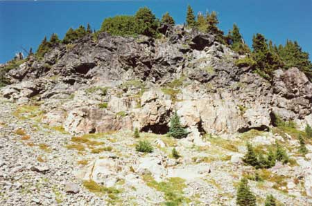
|
| Figure 6.1 Mt. Pleasant Rockshelter (FS 72-02). Northeast facing shelter overlooks Mist Park in Mount Rainier's NW quadrant. |
In the short-term, it also may be useful to expand on existing rockshelter excavations, particularly at Fryingpan Rockshelter. Because this shelter is known to contain faunal remains and because original excavation controls and report contents were not rigorous by moderns standards, the shelter offers a relatively easy opportunity to refine excavation procedures and expand the existing database.
Efforts also should be made to document plant (especially huckleberry) processing features. If found, a sample should be examined to determine feature morphology, use and temporal range. Because carbonized remains are relatively impervious to chemical degradation, macrobotanical samples of charred remains potentially will help identify the plants processed and wood species used for drying fires.
Combined results should provide a better grasp of faunal and floral exploitation patterns. If suitably stratified and well preserved, these data also will allow us to address changing resource procurement patterns through time. If primary attractors to Mount Rainier were the suite of resources listed above, then they should be heavily represented in the archeological record. Furthermore, if as anticipated, primary faunal exploitation patterns shifted from elk and deer to goats and possibly marmots through time, the pattern should be reflected in changing frequencies in stratified remains. Huckleberry use is expected to be limited to very late prehistoric and historic times. In addition to resource data, test procedures will improve our understanding of temporal range, assemblage characteristics, and site distribution and use patterns on Mount Rainier–all useful for dealing with remaining questions below.
When Did Hunter-Gatherers Use the
Mountain?
At the close of Chapter 2, I posed three sets of time related questions about 1) seasonality; 2) onset of earliest human activity; and 3) temporal variation in land-use strategies or intensity on Mount Rainier. Logically, at least, seasonality appears to be the easiest of the three questions to address. Mount Rainier's winter climate places severe constraints on human use. Aside from obvious (but solvable) problems of cold, wet weather and deep snowpack, are more serious winter resource-related issues. Subalpine to alpine habitats, where critical resources are most abundant, are virtually unusable from late fall through spring. Even with reliable winter access, there would be little to eat. Elk and deer overwinter in lower elevation foothill and valley settings. Marmots hibernate in high elevation dens. Pika burrow under subalpine snow. Goats move to upper forest habitats to shelter from wind and deep snow. At best, winter available food would be limited to goats, sheep and hibernating bears. Even these animals would have gotten thinner as winter progressed. Accordingly, there is little doubt that winter use of the mountain was very limited, or idiosyncratic and irregular. As intelligent predators, prehistoric hunter-gatherers can be expected to have followed their primary prey upslope during the summer, leaving with them in the autumn when snow returned and the upland resource base declined.
Earliest possible hunter-gatherer use of the Cascades must coincide with development of glacier free game habitat coincident with human presence in the region. In the vicinity of Mount Rainier, both criteria appear to be met at about 8,500 years ago. While human population density was undoubtedly low at this time, temporally coincident extinction of Pleistocene megafauna would have favored increased exploitation of medium-sized animals wherever they occurred–including Mount Rainier if suitable glacier-free habitat was available.
Despite early Holocene development of forested montane habitats, there is reason to expect that regular use of Mount Rainier's upland habitats would not have begun until Hypsithermal climatic conditions ameliorated. Paleoenvironmental data discussed in Chapter 2 suggest that the relatively warm, arid Hypsithermal climate contributed to maintenance of low maturity, open forests in the Puget lowlands and Cascade foothills from about 7,500 to 5,000 years ago. While comparably aged data are unavailable from Mount Rainier, hypsithermal snowpack repression should have had an effect on high elevation forests opposite that of the lowlands. All else being equal, the longer, somewhat warmer upland growing season should have permitted forest expansion into what now are subalpine and alpine zones. Accordingly, during the Hypsithermal Interval, ungulate forage should have been relatively abundant in lowland and foothill settings and limited in higher elevation montane settings. Given low population density and relatively abundant lowland resources, there is little reason to expect substantial use of higher elevation places at this time. In short, while earliest use of Mount Rainier may be expected by about 8,500 years ago, such use may have been limited and associated archaeological sites rare relative to foothill and valley settings. Use of Mount Rainier should have increased sharply about 6,000 to 5,000 years ago due to elevated population demands, expanding lowland forests and improving upland ungulate habitat; environmental features plausibly associated with onset of cooler, wetter conditions at the end of the Hypsithermal.
The third and most complex question deals with potential variation in the nature and intensity of Mount Rainier land-use over time. McClure (Chapter 3) and Benson and Lewarch (1989) have suggested a 1,000 to 2,000 year abandonment of the southern Washington Cascades, possibly due to increased late Holocene volcanic activity. Schalk (1988) suggests that use of montane uplands was an early Holocene phenomenon fit to foraging land-use patterns that was effectively terminated with the shift to lowland focused collector strategies about 4,000 years ago. It is also possible that other less dramatic land-use changes were associated with climatic oscillations shown on Table 2.3 and noted above.
In my opinion, there presently are neither empirical nor theoretical grounds sufficient to infer prolonged abandonment of Mount Rainier and the southern Washington Cascades during the Holocene. At the very least, there are compelling empirical grounds to dismiss importance of volcanic events as a likely cause. Citing pollen data from the southeastern flank of Mount Rainier, Dunwiddie (1986) notes that Holocene vulcanism had minimal impact on forest composition. If vegetation patterns were essentially unaffected by these events, then it is unlikely that and human use patterns were substantially influenced, and certainly not for a 1,000 years or more. While it is possible that post-Hypsithermal environmental changes had short-term impact on land-use patterns, it is unlikely that these changes were severe or lasted long enough to have a marked effect on regional population levels or broad-scale land-use practices. In the absence of other compelling environmental or theoretical grounds to anticipate a marked mid-to-late Holocene land-use hiatus, regional population processes should be considered continuous (i.e., generally increasing) throughout the Holocene. If so, changes in Mount Rainier land-use patterns, if any, would have to reflect the operation of processes other than temporary abandonment of the general area.
Schalk (1988) argued for a substantial shift in mid-Holocene upland use patterns without relying on external environmental mechanisms or a region-wide population hiatus. Rather, he suggested that use of montane uplands declined sharply due to logistic reorganization associated with adoption of lowlandbased collector strategies. Schalk's ideas received substantial attention in the preceding chapter because, despite being theoretically well-grounded and perhaps applicable to the maritime context of the Olympic Peninsula, they are not consistent with existing Mount Rainier data; which indicate continuing use of subalpine habitats throughout the Holocene
Evidence for continuing use of montane uplands, despite apparently compelling theoretical reason to the contrary, can be explained by a change in land-use strategy rather than abandonment of montane habitats altogether. I suggest that about 4,000 years ago upland use declined on a per capita basis and shifted from rest-rotation foraging by residential groups to 1) use by remnant foragers coexisting on the margins of collector society; and/or 2) use by limited-task collector groups exploiting alternative high elevation resources while insuring that ungulate herds were not depleted by others. Pressures for extension of territorial boundaries and protection of subalpine "pasture lands" by limited-task groups tethered to lowland villages is expected to become acute after about 2,500 years ago.
In sum, theoretical arguments buttressed by limited, but not insignificant, environmental, geological and archeological data suggest summer season use of Mount Rainier subalpine and alpine habitats as early as 8,500 years ago, increasing sharply at the end of the Hypsithermal Interval circa 5,000 years ago. Assuming that the region was not abandoned and that post-Hypsithermal climatic oscillations were insufficient to cause significant land-use changes, seasonal use of subalpine habitats is expected to have continued throughout the Holocene. After about 4,000 years ago, and particularly after 2,500 years ago, uplands use may have shifted from primary dependence on large ungulates hunted by residentially mobile foragers to use of alternative resources by collectors whose primary task was to protect remaining herds from overuse by other groups.
Mount Rainier Data
Present Mount Rainier archaeological data tell us little about initial use of the Mountain or land use changes through time. Presently the only indications of very early use are style and hafting width attributes of projectile points found in surface context. Hamilton's analysis of these artifacts (see Table 4.7 and associated text in Chapter 4) suggests that use of the mountain began prior to 5,000 years ago and continued to at least 2,000 years ago. Temporal inferences based on stylistic attributes of individual artifacts, however, must be regarded as suspect in lieu of supporting stratigraphic or radiocarbon data.
The probability of recovering stronger chronometric data is good. Because of substantial land area with deeply buried older sediments, it is possible that very old subsurface cultural horizons are preserved in the Park. Unfortunately, deeply stratified cultural deposits have yet to be documented. Existing data do not allow us to extend the time line past the ca. 3,400 year old remains eroding from the Sunrise Ridge Borrow Pit site (FS 90-01). Radiocarbon dated remains from Berkeley Rockshelter (FS 86-02), archaeological materials atop 2,300 year old Mount Rainier-C tephra, and widely scattered arrow points suggest continuing use during the late Holocene as shown in Table 4.7. However, because these data are widely scattered and not tied to a controlled set of assemblage and resource data, they are not suited to address possible land-use changes through the time period represented.
Recommendations
Clearly, the nature of the questions posed are best met with old and/or well stratified cultural deposits. Paleoenvironmental data can also be useful for establishing earliest post-Pleistocene floral colonization of Mount Rainier. These data, usually derived from deep pollen core samples, also can be useful for refining our understanding of broader Holocene forest associations and environmental changes. To deal with temporally relevant issues addressed in this section I recommend 1) subsurface reconnaissance and erosion face survey to identify deeply stratified deposits; 2) sample excavation of a subset of what appear to be the best stratified deep sites; and 3) extraction of a set of paleoenvironmental core samples with palynological/archaeological interpretation of results. Of course, rockshelter research recommended above also may be useful in providing temporally sensitive data.
Our understanding of the onset of human use of Mount Rainier and changing patterns in that use can best be improved through sample excavation of one or more deeply stratified sites. Because of widely distributed Holocene volcanic deposits and reason to expect long-term human use of the mountain, it is likely that deep sites exist and ultimately will be found. Tephra rains that created well-stratified horizons, however, also buried them, making older deposits difficult to identify. The first goal, then, is to identify older subsurface cultural materials.
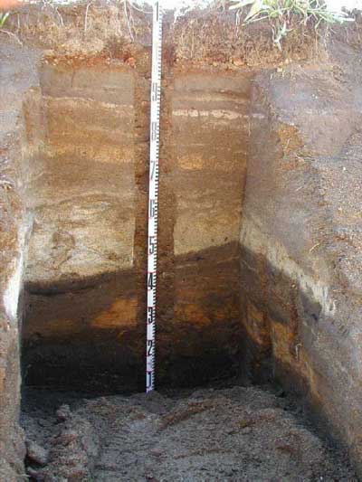
Perhaps the most practical means to identify buried site components is to a) routinely examine erosion faces for buried artifacts and features; and b) incorporate subsurface auger tests to new survey efforts, and reexamine presently identified sites and high site probability landforms. With minimal clearing, erosion scars provide ready-made stratigraphic profiles, some with substantial depth. Figure 6.2 below, for example, shows a an erosion exposed stratigraphic sequence on the east-central side of Grand Park. The dark, lowest stratum (base of the meter stick) is a paleosol predating the lighter (orangish) layer of circa 6,800 year old Mazama tephra. Other strata higher in the profile document repeated fire history on Grand Park as well as multiple volcanic episodes. Similar scars (with visible Mazama tephra) can be seen on the alpine landscape west of Frozen Lake (FS 86-01) and elsewhere in the Park. Even though such exposures are not systematic and cannot guarantee presence of cultural remains, they offer an easy means of building familiarity with the Park's sediment and environmental sequence. In some cases, they also may intercept features and artifacts similar to those in the borrow pit exposure at site FS 90-01 on Sunrise Ridge. Of course, profile faces must be repaired when complete to minimize acceleration of erosion processes.
|
| Figure 6.2 Profiled Erosion Scar in Grand Park. The profile displays circa 6,000 years of stratified deposits (sediment core removed from center). |
Systematic subsurface auger testing is probably the most effective way to identify buried archaeological components. Though time consuming relative to surface-only survey, deep testing may be the only way to locate older cultural remains at places like Mount Rainier where sediments have accumulated during the Holocene. Experience elsewhere in the Cascades has shown that very low volume test units, when systematically placed in sufficient number, can effectively identify even low to moderate density site components (Burtchard 1991; Werth et al. 1994; Burtchard and Miss 1998). Small volume auger or shovel test grids also have the advantage of minimizing damage to surface vegetation in the testing process.
To maximize deep site discovery potential, I suggest that auger test systems be employed at presently identified sites and isolated finds situated on landforms with relatively deep deposits as shown above. [43] In some cases, buried components will likely be found. Once a sample of these have been identified, a subset of the most productive or deepest sites should be examined further with larger excavation units to obtain more complete assemblage, temporal and resource data.
Deep sediment/pollen cores is the best data source for paleoenvironmental reconstruction research. These data are needed to refine the time line for development of, and change in, Holocene floral associations on Mount Rainier. Dunwiddie's (1986) paleoenvironmental work on the mountain's southeastern slope was useful in this regard, but its inferential scope was limited by the small number of cores and the 6,000 year old sediments from which his samples were taken. Where overlying older Holocene sediments, lake and marsh settings typically provide the best pollen capture and preservation qualities for expanding on earlier studies like Dunwiddie's.
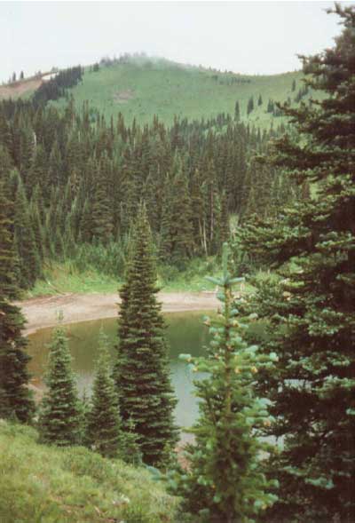
Figure 6.3 shows Buck Lake, a particularly promising pollen trap in direct association with prehistoric site FS 71-01 in the Park's NE quadrant. I recommend that paleoenvironmental cores be extracted from this and similar settings on various sides of the mountain. Carefully structured studies conducted with combined palynological and archaeological expertise can provide a cost-effective means to improve our understanding of Holocene floral and environmental patterns with implications for human use of the mountain. Sediment/pollen cores also facilitate study of temporal variation in charcoal density. Charcoal patterns help to understand fire frequency and fire ecology, and may help clarify whether or not mid-Holocene populations used fire to improve ungulate habitat.
Where Did Montane Hunting and Gathering
Activities Take Place?
The issue of where prehistoric groups focused their activities assumes that use was spatially patterned and repetitive over time. Assuming that use of Mount Rainier was geared primarily toward exploitation of economically useful plants and animals, then variables that affected their distribution would necessarily influence the distribution pattern of humans that came to get them. Threaded throughout this report is the notion that most of these resources are highly patterned in high montane environments. Over long stretches of time, the most valuable prehistoric resources on Mount Rainier tended to aggregate in highest density and with the greatest predictability in subalpine and alpine habitats over 5,000 ft. Accordingly, we can expect prehistoric use, as reflected by the archaeological record, to conform to this pattern as well.
There is no doubt that prehistoric site distribution patterns on Mount Rainier are biased toward subalpine and alpine habitats. In fact, ecological arguments, archaeological data and ethnographic accounts are so strongly consistent with patterned use of these settings, that "where" questions are really best directed toward understanding the exceptions rather than the rule. That is, where can we expect to find prehistoric remains in settings outside of subalpine or alpine habitats? Exceptions noted in this report include 1) residential base camps in upper forest/subalpine ecotone; 2) rockshelters wherever they occur; 3) cryptocrystalline lithic exposures; 4) cedar groves; 5) early succession burns; and 6) trails.
|
| Figure 6.3. Buck Lake Site FS 71-01. Looking SE from the site, photo shows the lake and upper forest/subalpine ecotone. |
Use of the upper forest ecotone is only a slight deviation from the subalpine pattern–one that I believe reflects a pragmatic adaptation to use of subalpine and alpine habitats given Mount Rainier's unstable weather patterns. Plausibly, use of the upper forest fringe reflects either a) use at times when forests were lower than present (e.g., during the Garda Stade glacial advance circa 750 years ago); or b) use for weather protected residential base camps. Because of the proximity to subalpine of documented sites such as FS 71-01 at Buck Lake (Figure 6.3 above), FS 90-01 on the side of Sunrise Ridge and FS 95-10 downslope from Indian Henry's Hunting Ground to the forest fringe it is hard to unequivocally dismiss the possibility that they were used at times when the subalpine zone was lower than present. However, surface visible remains exhibit greater lithic density and complexity relative to most higher elevation locations. Because of combined assemblage and location characteristics, these forest-subalpine ecotone sites are tentatively classified as base camps out of which hunter-gatherer groups operated while in residence on Mount Rainier. Data recovery research is recommended to provide firmer grounds to evaluate use of these potentially important prehistoric places.
Rockshelters offered a source of natural shelter with minimal modification. Since Mount Rainier weather can be severe at any time of year, such shelters would have been at a premium to populations lacking modern camping subsidies. Because of their value, sheltering rock overhangs may have been sought out some distance from actual foraging locations. Even so, all presently documented rockshelter sites occur in or on the fringes of the subalpine zone. While the pattern will likely hold true as sample size increases, surveyors should be aware of their relatively high correlation with prehistoric remains wherever they occur.
Cryptocrystalline silicate (chert) exposures are found at several places on Mount Rainier. Such outcrops provide useful tool materials, thereby minimizing the need to carry heavy biface blanks or cores to the mountain. These sources bear no necessary association with subalpine or alpine habitats; though proximity maximizes utility. To date, only one lithic quarry site has been documented (FS 90-04 on Tum Tum peak in the southwest quadrant). Present survey results suggest presence of alternative, but as yet unidentified sources in the vicinity of Mt. Fremont in the northeast quadrant, and Windy Gap and Mist Park in the northwest quadrant. It is likely that most chert outcrops will vary in use intensity as a function of distance to subalpine hunting locations.
In the Pacific Northwest, cedar provides a source of easily split, weather resistant planks for lowland long-house construction, and fibrous bark for clothing, cordage, bags and baskets. Alaska yellow cedar is present in well watered low to mid elevation settings on Mount Rainier. Red cedar is found in some of the low elevation river valleys. It is reasonable to expect prehistoric people to have taken advantage of available Alaska and red cedar as a fiber source to assist with foraging and packing needs.
Bark peeled cedars have been reported in several lower to moderate elevation places in the Park (see Chapter 4). Locations are keyed to wet forest cedar habitat. Under ideal conditions, cedars may live over 1,000 years (Franklin and Dyrness 1973:48). Accordingly, examination of these sites may help us understand the location of late prehistoric travel routes into the Park. Core sampling may provide information relevant to possible temporal patterns in their use. According to McClure (pers. com. 1996) peeled cedar sites also may be correlated with huckleberry processing areas (cedar bark used to make containers). If so, survey centered on bark scarred cedar locations may be useful in the search for huckleberry processing sites recommended above.
The final two categories of exceptions to the subalpine pattern– prehistoric burns and trails–are difficult, perhaps impossible, to establish for other than historic or very late prehistoric events. Burns can be important resource procurement areas because they temporarily lower forest maturity, improving ungulate and huckleberry habitat. The location of burns is not bound solely to upper elevation settings. Natural burns may have been used during early succession stages, or even intentionally fire-maintained to elevate productivity. If so, an archaeological record should accumulate in now-forested mid-slope settings. Even though current data do not indicate presence of low elevation sites, it is important that reconnaissance efforts continue to include low to mid-elevation forested landscapes. In forested settings, experience from elsewhere in the Cascades suggests a site pattern keyed to ridges, side slope benches, and elevated stream terraces (Burtchard and Keeler 1991).
Trails are patterned on the landscape, but cross a variety of environmental zones linking the uplands to lowland overwintering areas. Like burn areas and cedars, however, their impact on the landscape tends to be ephemeral, making them difficult to locate. Historical and ethnographic sources represent the best sources of information on the location of these routes. Though they cannot be tied unambiguously to early or middle Holocene use of the Park, they show plausible routes that can serve as examples and, in many cases, probably have greater antiquity.
Mount Rainier Data
Because of the large number of location-related issues, current archaeological information has been indicated in the body of the general discussion above. The most salient point is that the extant archaeological record strongly indicates use of subalpine and alpine zones on all sides of the mountain. Deviations from this pattern reflect selection of sheltered upper forest locations within easy reach of subalpine hunting areas for use as residential base camps, and places with particular qualities not linked to upper elevation habitats (chert quarries, bark peeled cedars, perhaps rockshelters). It is likely that mid-elevation forests were used at lower density, particularly in the vicinity of prehistoric burns. Present Mount Rainier site data, however, do not include sites in these contexts. Sections of at least one undocumented trail are known near site FS 90-01 on Sunset Ridge. Others are cited by Smith's (1964) Indian informants. Additional site types and locations such as stacked rock features are likely to exist in the Park as well, but as yet have not been documented.
Recommendations
The best way to improve our understanding of distribution patterns is to expand survey coverage. The present project was directed toward consolidating existing site reports with limited new reconnaissance. To expand this beginning effort further I recommend: 1) consolidation and field evaluation of remaining unverified site reports; 2) additional survey designed to sample the full range of Park landforms in all four quadrants; and 3) interviews with informed residents and local Tribal representatives to develop a more complete view of early historic land-use practices and travel routes. Survey procedures should include, or supplement, rockshelter reconnaissance and testing efforts recommended above and subsurface testing techniques to identify old site components.
Site data summarized in this volume pulls together all known site and isolate localities for which we were able to find credible information during the field effort. There is little doubt that additional localities are known to Park employees and informed persons that were not interviewed. This information, coupled with field evaluation, constitutes an effective, inexpensive means of expanding the prehistoric and historic site data base. Because these reports tend to come from all parts of the Park, resulting site data reflect "inspection" of a variety of habitats and landforms, despite the fact that they are not rigorously systematic in a sampling sense.
Additional formal survey would also be a useful addition to the present reconnaissance. Survey procedures should be structured to sample landforms and environmental zones widely on all sides of the Park. To the extent possible, low volume subsurface auger and/or shovel probe techniques should be used to search for buried components where surface remains are present, and on high site potential bench, terrace and ridge top settings. Resulting information can be added to similarly examined site data to develop sample excavation plans suited to a number of research options.
Allied with general site report interviews are discussions with representatives of Indian groups on all sides of the mountain. To my knowledge, the only systematic attempt to solicit land-use information about Mount Rainier from Tribal members was Allan Smith's (1964) work for his Ethnography of Mount Rainier. In addition to improving interpersonal and intergovernmental relations by involving neighboring tribes and Indian Nations with studies of concern to their history, living tribal members may yet offer useful information on traditional use patterns and travel routes to and from the mountain. Such information may be particularly useful for clarifying and expanding on such issues as reported use of Sunrise Ridge for "late summer fairs" (Morrison pers. com. 1995), travel routes and use of places like "Indian Henry's Hunting Ground"(Bjarke 1949; Smith 1964), and early historic period huckleberrying, hunting and travel patterns generally.
How Did Regional Settlement Systems and Montane
Environments Affect Site Distribution Patterns?
Issues related to integration of Mount Rainier resources and landscapes into broader Northwest subsistence and settlement systems have been addressed throughout the report and formally modeled in Chapter 5. In essence, these models suggest that Mount Rainier–particularly its upper forest ecotone, subalpine and alpine habitats–has been used as a summer hunting and gathering area throughout much of the Holocene. Use may have begun as early as 8,500 years ago, or when the first essentially modern post-Pleistocene plant and animal communities successfully colonized Mount Rainier. Foraging is expected to have increased markedly about 5,000 years ago as the climate cooled from the post-glacial Hypsithermal rebound, expanding the size of alpine and subalpine habitats on Mount Rainier. During this time, Mount Rainier's subalpine zones would not have been remote places, but essentially "summer neighborhoods" where small, politically autonomous forager groups maintained residence while the weather was warm and resources plentiful; moving downslope when winter drove game to foothill and valley settings. Human distribution patterns should have been fluid, shifting from place to place as dictated by the abundance and distribution of exploitable plants and animals.
During the middle Holocene, subsistence and settlement systems–while still keyed to a basic hunting and gathering economy–changed perceptibly, perhaps dramatically. A mobile foraging system can only work while human population density is low relative to critical animal and plant populations. Wild, unmanaged resources have finite limits that cannot be exploited indefinitely if population density continues to increase. Primarily because of population/predation pressures–probably exacerbated by post-Hypsithermal environmental changes–forager strategies became incapable of reliably sustaining Northwest hunter-gatherers. Since prehistoric agriculture is a practical impossibility across the region, successful groups developed techniques to exploit available resources more intensively–to "squeeze" more food out of increasingly limited available space. In practice, this meant adopting winter-sedentary land-use strategies centered on productive salmon rivers or other areas with resources that could be mass harvested and stored, and instituting more complex, labor intensive, logistic resource acquisition and distribution mechanisms. Mobile foragers became semisedentary collectors.
These intensification processes now appear to taken place across the Pacific Northwest about 4,000 years ago. They become more pervasive through time until catastrophic diseases decimated indigenous populations between 400 to 150 years ago. It is only after development of semisedentary lowland-based economies that Mount Rainier may have become viewed a remote place, if indeed it was at all. The mountain's upland habitats and summer resources– now insufficient to support regional populations–lay some distance from village centers and conflicted with warm season collecting and storage obligations in the lowlands. At least two of the most important hunted species–elk and deer– after all, would return to the lowlands of their own accord in the winter and be hunted when need was greatest. Accordingly, reasons for journeying to Mount Rainier and similar montane uplands could very well have been less compelling than before, resulting in diminished use overall as suggested by Schalk (1988) for the Olympic Mountains.
Even so, use of Mount Rainier did not stop during the later Holocene. To accommodate this apparent paradox, the model suggests that primary upland use shifted from summer residence by autonomous forager groups (though limited use by marginalized foragers may have continued), to use by sub-groups dispatched from larger collector societies to hunt as necessary for self support while seeing that upland resources were not overused by others. Because of logistical difficulties inherent in foot transport, collection of stored commodities for return to lowland villages is not expected to have been a primary concern of these limited-task groups. It is plausible, however, that lighter and/or particularly valuable commodities unavailable in the lowlands (e.g., goat wool) were carried out at season's end. Mass use of huckleberries is expected to have become particularly important after introduction of the horse enhanced transportation options about 300 years ago.
Much of the scenario outlined above and considered in detail in Chapter 5 is deduced from a body of ecological and evolutionary theory. Available regional data are consistent with basic tenets of the forager to collector shift. Data relevant to finer details, such as late Holocene extension of protective territorial boundaries to the uplands, remain scant. The model is intended to provide an interpretive framework for developing research questions and for evaluating results which, if implemented, will facilitate progressive refinement of our understanding of the past. If the present model approximates past reality, several predictions should hold for Mount Rainier's archaeological record. The following list includes some of the more obvious. Readers are encouraged to generate others.
1) Earliest cultural remains on Mount Rainier should date to ≥ 8,500 B.P.
2) Site density should exhibit punctuated increase circa 5,000 B.P.
3) Early Holocene forager sites should be dominated by full residential assemblages in close spatial association with hunting and lithic procurement localities.
4) Faunal profiles associated with forager sites should be dominated by, or contain relatively high fraction of, larger ungulates, principally elk and deer.
5) Due to high residential mobility and uncertain return to same-site locations (limiting effectiveness of implement caching), early Holocene tool kits should be relatively simple and dominated by multi-functional implements fit to killing and butchering large animals.
6) Early Holocene forager sites should lack mass harvest and storage features.
7) Mount Rainier's broader archaeological record should span the entire Holocene time frame after initial settlement.
8) Late Holocene collector sites should exhibit increased intersite variability relative to early Holocene forager sites. Residential base camps should remain to accommodate prolonged stay.
9) The late Holocene faunal record should show increased fraction of smaller body sized game relative to elk and (perhaps) deer. [44]
10) Late Holocene site locations should tend to be reused resulting in greater accumulations of material remains.
11) Late Holocene increased task variability, site reuse and enhanced effectiveness of equipment caches should be expressed as increased variability in artifact and material types, and artifact density.
12) Possible late Holocene evidence for mass harvest of high value, low bulk commodities such as goats (for wool) and marmots (for fat).
13) Mass huckleberry drying features should date to late prehistoric or historical times.
Mount Rainier Data
Extant information can touch on only a few of the issues that potentially could be addressed with archaeological research at Mount Rainier. The least ambiguous of these is the very clear indication of continuing use of subalpine and alpine habitats throughout the latter part of the Holocene. Existing data also indicate surprising intersite variability; including residential base camps at the forest/subalpine ecotone (see Figure 6.3), plus limited task butchering, lithic procurement and reduction, and field hunting camps and locations as discussed in the first section of Chapter 5. Analyzed lithic assemblages also indicate intersite diversity in lithic technology, density and material types (see Tables 4.3 and 4.8). Site distribution patterns suggest use by people on all sides of the mountain
Recommendations
The capacity to address the range of research possibilities noted above requires long-term commitment to a coordinated research effort, directed by persons familiar with the processual approach to prehistoric research and well versed in montane archaeology. Though useful in an a cumulative sense, independently conducted, uncoordinated testing and salvage efforts operating with project-specific goals seldom are capable of addressing broader subsistence and settlement oriented research issues. Summary research recommendations in the following Management section are intended to begin that process by focusing on specific, staged research objectives. Recommendations specifically designed to address complex land-use issues summarized above rely primarily on 1) better defining the temporal record; 2) developing a site and temporally sensitive faunal and floral record; 3) completing assemblage comparisons reflecting the range of temporal and site type diversity on Mount Rainier; and 4) consolidating existing test and data recovery data from the southern Washington Cascades (and beyond) into a format suited to intersite comparisons with Mount Rainier data. It also is important to incorporate historic period remains–at least into survey procedures–if the Park wishes to pursue a truly broad-based approach to its archaeological record.
Options that address most of the four recommended research areas above have been outlined in earlier Why, When and How discussions. Perhaps the area most worthy of further comment is the notion of gaining more complete, excavated samples from sites representing a broad temporal and functional range. I suggest that test/data recovery efforts focus on comparison of deposits at one or more each of the currently recorded site types as defined in Chapter 5 and listed in Table 5.1. Recognizing practical time and budget constraints, initial efforts should try to maximize return by emphasizing sites with the greatest potential for providing data classes sought. Initially it is recommended that research efforts be directed toward 1) possible residential base camp site FS 90-01 on Sunrise Ridge; 2) expansion of earlier work done at Fryingpan Rockshelter site FS 63-01; 3) excavation at open sites FS 95-04 on Sunrise Ridge and/or FS 95-05 in Spray Park; and 4) sample excavation at Frozen Lake site FS 86-01.
The recommended sample is based on present information only and should be changed if new data (e.g., deep sites located by auger or erosion face profile work) suggest that work could more profitably be directed elsewhere. If implemented as recommended, however, the sample would include sites presently classified as residential base camps, rockshelter and open hunting camps, and a butchering location. Work at the Sunrise Ridge Borrow Pit site (FS 90-01) seems particularly pressing because of extensive damage and continuing site erosion resulting from mechanical removal of fill for road construction and other Park purposes. Fryingpan Rockshelter (FS 63-01) was chosen because of established content, though Vernal Park and Mt. Pleasant Rockshelters noted below are tempting alternatives. Sites FS 95-04 and FS 95-05 have a moderate density and variety of remains in an as yet uninvestigated site type. Site FS 95-04 offers the advantage of proximity to several day trails leading from the Sunrise Ridge Visitor's Center. Excavation here could be integrated into an interpretive program certain to attract substantial public interest. Spray Park site FS 95-05 broadens the sample away from the northeast quadrant, and would recover information in a setting that is being denuded and eroded by use. Finally, site FS-01 at Frozen Lake offers our best opportunity to examine what appears to be both a lithic reduction and butchering locality. It also is one of the few sites in true alpine context. The site has been disturbed to an unknown extent by artifact collecting and frost heaving. Sample excavation would recover remnant information, examine cryoturbation impacts and improve the quantitative base for its functional interpretation. As with FS 95-04, excavation at Frozen Lake site would stimulate substantial public interest, offering unique interpretive opportunities for the Park Service.
Sample excavation of additional localities and site type classes, could only improve our understanding of Mount Rainier's prehistoric land-use practices. I hope that other important sites such as FS 71-01 at Buck Lake, FS 95-10 below Indian Henry's Hunting Ground, Vernal Park and Mt. Pleasant Rockshelters (FS 74-01 and FS 72-01), limited use locations such as FS 95-08 and FS 90-03 near Windy Gap, and others can be added as research needs and budget realities dictate. In all cases, care should be taken to structure excavation and analytical procedures and evaluate results in a fashion that can meaningfully address research issues such as those introduced here.
| <<< Previous | <<< Contents >>> | Next >>> |