Environment, Prehistory & Archaeology of Mount Rainier National Park, Washington
Greg C. Burtchard
Chapter 2:
ENVIRONMENT AND LAND-USE ON MOUNT RAINIER & IN THE SOUTHERN WASHINGTON CASCADES
(continued)
MOUNT RAINIER AND SOUTHERN WASHINGTON CASCADES
GEOLOGY
The Cascade Range may be divided into two north to south physiographic provinces with Mount Rainier in the middle. The broad North Cascades province extends from the Frazier River in southern British Columbia to Snoqualamie Pass between Glacier Peak and Mount Rainier. The more elongate, narrower South Cascades province extends from the pass (or Mount Rainier) south, across the Columbia River, ultimately terminating at California's Mount Lassen (see Harris 1988 and Whitney 1983:15-30; Burtchard 1990:33-36). Partially due to its position at the northern extreme of the southern province, Mount Rainier's geology shares certain characteristics of each.
Environmental Implications of General Cascades
Geology
There are substantial differences between North and South Cascade physiographic provinces that influence environmental and resource patterns in each. [4] The North Cascades Province is a massive area of old metamorphic and sedimentary rock rafted ashore over 50 million years ago. In origin, these mountains are more closely related to British Columbia's Coast Mountains and Washington's Olympics than to the Cascades further south. The North Cascades also are a substantially broader and higher massif composed of rugged high elevation peaks with deeply incised valleys. Vertical relief tends to be high with elevations ranging from near sea level in major valleys to over 9,000 ft on many of the North Cascade peaks. Due to elevation, breadth, and proximity to moist Pacific storms, the province supports the largest overall number of active glaciers in the lower 48 states.
North Cascades geomorphology has had a marked influence on regional climate, exploitable resource structure and, hence, human use throughout the Holocene. Regional rock types include a variety of geologically distinct exposures, a number of which are suitable for tool manufacture. Forest cover is influenced by exposure and elevation. Maritime forests blanket the western slopes from sea level to timberline at about 5,500 ft. On the eastern slope, forests extend from about 1,000 ft to timberline at 6,500 ft. Timberline on both sides is controlled by deep snow pack that persists into midsummer. It is possible that presence of expansive open habitat supported abundance and variety of floral and faunal resources throughout the Holocene. As in the south, rivers and tributary systems provide entry for anadromous fish. There is little doubt that available resources were sufficient for seasonal use by local populations, provided strategies could accommodate the short growing season and logistical difficulties imposed by rugged terrain, relatively massive breadth and unstable high elevation weather. While not part of the North Cascades per se, it is important to note that most of these environmental qualities and land-use implications apply to Mount Rainier as well.
The South Cascades Province is a generally narrower band of old, highly weathered volcanic mountains, tilted and partially overlain by younger and higher, spatially isolated stratovolcanos along its eastern axis (e.g., Rainier, Adams, Hood, Jefferson, McLoughlin, Shasta and Lassen among others). Most high Cascade mountain building volcanism took place in the Pliocene and Pleistocene 4-1/2 to 3 million years ago, with localized, but significant, activity throughout the Holocene. Except for the high peaks, few of the South Cascade mountains rise above timberline. Forest cover tends to be dense on the western slope grading to more open fir and pine forests on mid to lower elevation eastern slopes. The high peaks, however, are ringed by subalpine and alpine zones that support a variety of floral and faunal resources. Unlike the north, however, parkland and tundra zones are seldom interconnected, but tend to occur as independent, island-like patches within a more uniform forest cover. [5] The South Cascades also have complex drainage systems, many of which support anadromous fish populations.
At a very general level, the entire Cascade Range offered roughly similar economic opportunities and posed comparable constraints to prehistoric people. Both northern and southern provinces offered seasonally available food, fiber, and lithic resources. Severe weather effectively precluded over winter residence in both, and montane landscapes posed varying degrees of logistical difficulty. However, because of their narrower breadth and gentler physiography, the South Cascades probably posed less severe impediments to seasonal use. Vertical relief and distances were less imposing; and with the exception of the highest Cascade peaks, weather was more predictable; making possible longer seasonal use. These effects were counterbalanced to an unknown extent by the small size and isolated character of productive subalpine and alpine resource zones.
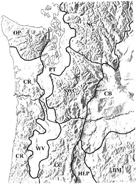
Situated near the boundary of the two provinces, Mount Rainier shares characteristics of both. Indeed it is reasonable to refer to montane landscapes from Rainier south to the Columbia River as the southern Washington Cascades physiographic region. Doing so recognizes the area's distinct geological and environmental qualities that distinguish it from its Cascade neighbors to the north and south. Franklin and Dyrness (1973:21-23) offer perhaps the best general summary of these characteristics. Near Mount Rainier, they emphasize the North Cascades-like pattern of accordant ridge crests separated by steep, deeply dissected valleys. Here, ridge crests are relatively high (averaging circa 2,000 m [6,560 ft]), decreasing abruptly to the south (circa 1,200 m [3,936 ft]). Volcanic rock dominates lithic exposures. To a greater extent than elsewhere, southern Washington Cascade landforms are mantled with pumice deposits of variable age, origin and thickness (Franklin and Dyrness 1973:22). Most of these deposits are from Holocene eruptions on Mount Rainier and St. Helens– events which periodically buried the material remains of prehistoric populations using these mountains. Figure 2.1 shows the southern Washington Cascades in relation to surrounding physiographic provinces/regions.
| |||
Figure 2.1 Southern Washington Cascades
and Surrounding Physiographic Provinces (after Rosenfeld 1993:41; see
also Franklin and Dyrness 1973:6. Mount Ranier is about 1/2 inch above
the "C" in SWC)
|
The contrast between the southern Washington Cascades and mountains south of the Columbia River is most sharply visible near Mount Rainier. Mount Rainier's great height and mass supports larger glacial, alpine and subalpine expanses than its southern counterparts. The mountain's size also creates a pronounced rainshadow effect on its northeastern flank, making for more open, patchy forest cover than would otherwise be expected. Furthermore, the breadth, elevation and deeply incised character of the surrounding mountain and ridge system is greater than that further south, mimicking the North Cascades pattern. These qualities make for expansive subalpine and alpine habitats (particularly on Mount Rainier) but make them more logistically challenging to exploit by lowland-based populations. To a greater extent than most of the Southern Cascades, Holocene vulcanism altered the character of the archaeological record through repeated tephra deposits and by destructive mass wasting events (especially lahars).
Mount Rainier Holocene Geology
The modern appearance of Mount Rainier and the southern Washington Cascades is the culmination of Pliocene-Pleistocene mountain building and substantial Holocene modification. By 75,000 years ago, Mount Rainier had reached a height of about 16,000 ft (Harris 1988:240). Though modified by extensive glaciation, the mountain maintained much of that height until after the close of the Fraser/Wisconsin glacial episode circa 15,000 to 13,500 years ago. Most of the subsequent volcanic events that reduced, rebuilt and modified Mount Rainier's shape occurred during the last 7,500 to 5,000 years–a period that undoubtedly witnessed increasing human presence in the general region and on the mountain itself.
The single most massive destructive event (or series of roughly synchronous events) to affect Mount Rainier were the Paradise-Greenwater-Osceola mud and debris flows (lahars) occurring between 5,000 and 4,500 years ago (Scott et al. 1995:12). These events apparently were stimulated by eruption and collapse of Mount Rainier's summit; releasing tremendous volumes of ice, mud and unconsolidated debris down the east and northeastern facies of the mountain (Harris 1988:243). Most of the material (Greenwater and Osceola mudflows) rushed over Steamboat Prow and down both forks of the White River; covering lowland floodplains from the base of the mountain to the Puget lowlands as far away as Auburn, Washington near Tacoma. The Paradise lahar emanated from the same source, but flowed south then west down the Paradise and Nisqually Rivers beyond Ashford, west of the Park boundary. Limited deposits extended down the Nisqually as far as Yelm near Olympia (Crandell 1971; Pringle 1994:2G-1). These events removed about 2,000 vertical feet from Rainier's summit and erased the archaeological record of early Holocene human activity in its affected river valleys. Figure 2.2 shows the extent of the major Mount Rainier lahars, including the more recent Electron mudflow.
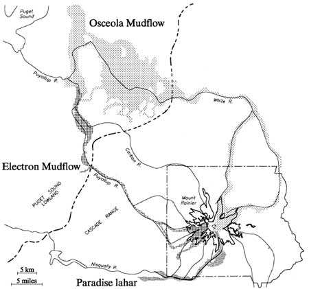
|
| Figure 2.2 Major Mount Rainier Lahars (after Crandell and Mullineaux 1967, and Crandell 1971) |
About 2,500 to 2,300 years ago, renewed eruptive activity on Mount Rainier filled the Osceola crater and rebuilt the mountain summit to approximately its present 14,410 ft height. This eruption ejected coarse-grained tephra (Mount Rainier Pumice Layer C) over the cone and much of the northeast and southeast quadrants of the Park. Gravelly Rainier C tephra is the modern surface on some of the Park's most familiar landscapes such as Sunrise Ridge and rolling alpine tundra between Frozen Lake and Berkeley Park. Deposits range from 2.5 to 20 cm (1 to 8 in) thick. We know that human use of the mountain predates this event by virtue of lithic debris eroding from below Rainier C tephra in borrow pit cut banks on the south slope of Sunrise Ridge (site FS 90-01 or 45PI408). It is likely that more rapid drainage qualities of the gravely tephra contributes to prevalence of patchier forest cover on the mountains lee. Mount Rainier C deposits also make site discovery more difficult, while simultaneously providing a protective, time-diagnostic cap over such deposits once found.
Lava flows associated with the Mount Rainier C eruption were limited to areas near the summit. However, these events spawned lahars which crashed into the White and Nisqually River valleys, again inundating and temporarily raising these valley floors within Park boundaries (Harris 1988:246). On these floodplains, the archaeological record again would have been effectively destroyed.
The most recent major lahar was the Electron mudflow about 500 years ago. This large, clay-rich mudflow (similar in composition to the Osceola flow) poured down the Puyallup and Mowich Rivers on Rainier's western slope. Though less massive than the Osceola flow, it inundated the Puyallup valley floor for almost the same distance into the Puget lowlands (see Figure 2.2). Lesser lahars occurred throughout the Holocene, continuing to the present. The above events are stressed to provide general familiarity with them because of their large scale and consequent impact on the archaeological record. The relatively high frequency and destructive power of such events points to a broader problem in interpreting the archeological record (or absence thereof) along Mount Rainier's river valley floodplains.
Mount Rainier's Holocene geological activity has not been limited to the destructive and creative events noted above. Of some importance to the archaeological record are Holocene tephra producing eruptions by Mount Rainier, Mt. St. Helens, and Mt. Mazama (now Crater Lake) in Oregon. Holocene eruptions from these sources created a complex patchwork of varying depth volcanic deposits, affecting different parts of the Park at different times during the period that humans could have used the mountain. While many of these events provide useful temporal markers for the Park's archaeological record, none are considered to have been of sufficient magnitude to have significantly altered montane land-use patterns in the southern Washington Cascades.
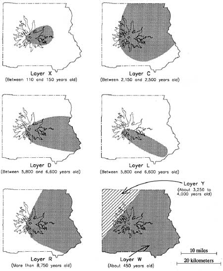
Our understanding of the mountain's volcanic deposition patterns remains incomplete (Pringle pers. com. 1995), but will improve as ongoing dating and mapping studies progress. Available sources have been consulted to provide an outline of depositional eruptive events known to have affected the Park in the last 10,000 years (Table 2.1). Figure 2.3 shows the approximate distribution of the best understood layers. The basic reference for Table 2.1 and Figure 2.3 is Crandell (1987)–who credits most of his information to studies by D.R. Mullineaux. All radiocarbon ages and partial data sets are from Scott et al. (1995) and Pringle (1994).
Table 2.1 Sources and Ages of Volcanic Deposits on Mount Rainier
| Tephra Layer | Thickness (in) | Fragment Dia. (in) | Color | Source | Age (14C years ago) | |
|---|---|---|---|---|---|---|
| West | East | |||||
| X | Absent | 1 | 1/4 - 2 | Light olive gray | Mount Rainier | 100 - 150 |
| W (Wn) | 0 - 1 | 1 - 3 | Medium sand | White | Mt. St. Helens | 470 |
| C | Absent | 1 - 8 | 1/4 - 8 | Brown | Mount Rainier | 2300 |
| P | Mt. St. Helens | 2500 - 3000 | ||||
| Y (Yn) | 5 - 20 | 1 - 5 | Coarse sand | Yellow | Mt. St. Helens | 3400 |
| B | Mount Rainier | 4500 | ||||
| H | Mount Rainier | 4700 | ||||
| F (poss. blast) | Mount Rainier | 5000 | ||||
| S (poss. blast) | Mount Rainier | 5200 | ||||
| D | Absent | 0 - 6 | 1/4 - 6 | Brown | Mount Rainier | 5500 - 6500 |
| L | Absent | 0 - 8 | 1/4 - 2 | Brown | Mount Rainier | 5500 - 6500 |
| N & A | Mount Rainier | 5500 - 6500 | ||||
| O | 1 - 3 | 1 - 3 | Flourlike to fine sand | Yellowish orange | Mt. Mazama | 6800 |
| R | Absent | 0 - 5 | 1/8- 1 | Reddish brown | Mount Rainier | >8750 |
|
| Figure 2.3 Distribution of Selected Volcanic Deposits on Mount Rainier (after Crandell 1987:14) |
Critical points to be made about Mount Rainier's Holocene geology are: 1) the mountain has been extraordinarily active during the time-frame in which humans could reasonably be expected to have used the Park; 2) these events to varying degrees modified the physical structure of the mountain; and 3) these events affected the archaeological record and, to a lesser extent, the character of prehistoric land-use practices. The most dramatic impacts involved destruction of very high elevation landscapes near the summit; and lahar destruction, in filling and subsequent down cutting of major river valleys. Because of extreme elevation, the effect on human use by the former should have been slight.
The impact on river valley land-use practices is more difficult to estimate. Repeated stream flow alteration undoubtedly had a negative effect on native and anadromous fish. Even so, it is likely that fish populations would have returned quickly once affected rivers regained stable streambeds. The primary impact may have been more to resource predictability than to absolute presence/absence per se. The latter is controlled by waterfalls and other major upstream impediments which limited anadromous fish to relatively few Park watercourses. Because of downstream obstructions and lahars emanating from above, human use of Mount Rainier's river valleys is likely to have never been important; particularly when compared to relatively resource-rich subalpine and alpine habitats. Unfortunately, repeated inundation of the floodplains makes riverine use difficult to examine empirically.
None of Mount Rainier's Holocene volcanic deposits were deep enough to have disturbed plant and animal associations in a massive way. Floral and faunal perturbations are likely to have been relatively short lived with insufficient impact on land-use patterns to show in the archaeological record. Even so, the tephra deposits make cultural remains substantially more difficult to locate. During the current reconnaissance, Mt. Mazama tephra was observed between 80 and 100 cm deep in several locations in the Park's NE quadrant. On the south flank of Sunrise Ridge, lithic debris were sandwiched between St. Helens Yn and Rainier C deposits 25 cm below the modern ground surface. While depth of cultural deposits vary with age and position on the mountain, it is clear that efforts must be made to locate prehistoric materials in subsurface context. It is important to recognize that materials documented by surface reconnaissance alone will tend to under-represent actual prehistoric site count, under-represent materials variability and abundance at identified sites, and bias results toward more recent, shallow deposits.
| <<< Previous | <<< Contents >>> | Next >>> |