|
MOUNT RAINIER
Wonderland An Administrative History of Mount Rainier National Park |

|
| PART SIX: YEARS OF CONSOLIDATION, 1965-1995 |
XXI. AN OVERVIEW OF PARK SCIENCE
INTRODUCTION
Scientific research has played an expanding role in park administration and resource management since 1965. Scientific data and analysis have been increasingly used to make policy, defend management decisions, and carry out new NPS mandates.
Applied research in the park has fallen into five broad areas: biology, sociology, environmental science, history, and geology. Most areas of applied research pertained to a distinct set of legislative mandates. Biological research, for example, pertained most directly to the park's organic act and the NPS mandate to preserve the area in a natural condition, but also stemmed from the Endangered Species Act of 1973. Environmental science mostly took the form of monitoring air and water quality not only because air and water pollution threatened park values, but also because new environmental laws established national standards and procedures which extended to the national park system. Historical research was required to satisfy the needs of historic preservation as mandated under the National Historic Preservation Act of 1966.
The park met these diverse research requirements in part by building up a staff of well-educated and trained resource specialists, in part by partnering with other research facilities. For biological research, the park superintendent turned to his own staff ecologists and botanists for some tasks and sought professional service agreements with universities for others. As the Park Service's research budget grew during the 1960s, its numerous contracts with universities eventually spawned a number of university-affiliated Cooperative Park Studies Units, of which the CPSU at the University of Washington, established in 1970, was the first in the nation. The superintendents of Mount Rainier National Park turned to that CPSU and subsequent CPSUs at Oregon State University and University of Idaho for most of the park's major biological research projects. The CPSU at University of Washington also comprised a sociology section to which the park turned for a variety of visitor use surveys in the 1970s, 1980s, and 1990s. These research projects often involved a combination of CPSU staff, university faculty, graduate students, and park staff. In handling all of these research projects the park received administrative help from the Pacific Northwest Regional Office, established in Seattle in 1969.
Meanwhile, the park turned to new divisions within the NPS for help with monitoring of air and water quality and inventorying of cultural resources. The Park Service's Air Quality Division, created in 1978, provided technical assistance to the park beginning in the early 1980s. NPS staff historians in the Denver Service Center, working in conjunction with the cultural resources division in the regional office, produced a historic resource study for Mount Rainier, an inventory of the park's historic resources, and a nomination of its significant resources to the National Register of Historic Places. These specialized activities were known collectively as "environmental compliance," inasmuch as the park administration had to comply with the National Historic Preservation Act, the National Environmental Policy Act, and other environmental laws. Park staff performed a limited amount of environmental compliance work, such as the preparation of Categorical Exclusions or the somewhat more involved Environmental Assessments (EAs) prior to any proposed action. But for more far-reaching actions, the park administration drew upon technical expertise in the regional office and the Denver Service Center. These experts provided the more sophisticated analysis that was commonly needed to complete an Environmental Impact Statement (EIS).
Finally, beginning in the 1960s the park turned to another federal agency, the U.S. Geological Survey, for research and advice concerning Mount Rainier's potential for a volcanic eruption. This was not a new partnership—the USGS had been turning out bulletins, professional papers, and scientific monographs on the geologic resources of national parks as long as the parks had been in existence. However, heightened public concern about the destructive potential of Mount Rainier placed new burdens on the park administration to take the public safety more into consideration, and the park administration did not have the capability to satisfy this need itself Park managers therefore turned to USGS geologists for assistance.
The remainder of this chapter describes scientific research in Mount Rainier at the project level. The discussion is not comprehensive; rather, it is intended to suggest the range and depth of the research program since 1965 and the extent to which the park administration reached outside the park staff for expertise. Further discussion of these research problems from a resource management standpoint has been presented in Chapters XIX and XX preceding.
BIOLOGICAL RESEARCH
Most of the applied research in Mount Rainier National Park involved biological resources. These research projects focused on threats to wildlife and plant communities and were closest to the heart of the NPS mission to preserve Mount Rainier National Park in a natural condition. What set this biological research apart from earlier biological research in the park was its quantity and sophistication. During the 1950s and early 1960s, the Park Service was criticized for its lack of commitment to biological research. Beginning in 1958, Congress appropriated funds for a program of applied science in the national parks, and in the early 1960s, a series of reports critiqued the fledgling science program and pointed it in new directions. The most important of these reports was the Leopold Report of 1963. The Leopold Report provided a new framework for biological investigations in Mount Rainier. [1]
The Leopold Report staked out an ambitious role for park biologists. Their research could give park managers the tools they needed to restore natural conditions in national parks, or at least manipulate nature such that the parks would closely approximate "vignettes of primitive America." The Leopold Report proposed that ecological successions could be an aid to park managers if ecological relationships were adequately studied and understood. "In essence," the report's authors boldly stated, "we are calling for a set of ecologic skills unknown in this country today." [2] Prescribed burning, reintroduction of extirpated plant and animal species, control of animal populations—these were just some of the tools that would be at the park manager's disposal.
Biological research in Mount Rainier moved beyond faunal surveys and investigations of individual species to consider whole ecological communities. Specific projects sought to place existing conditions in historical perspective, to consider the effects of past disturbances, and to obtain baseline data that would be useful in the future. While Park Service biologists no longer subscribe to the Leopold Report's objective of restoring natural conditions to some arbitrary point in the past, they still accept its premise that effective natural resource management must begin with the study of ecological processes. Major studies are described below in chronological order.
Subalpine Meadow Studies. Mount Rainier's modern science program began with Frank Brockman's ecological study of subalpine meadows in 1959-60 (Chapter XVII). This research project tapped funds that Congress had recently appropriated for applied science in the national parks, and it broke new ground with the making of a professional services agreement between the NPS and the University of Washington. [3] More importantly, Brockman's research anticipated the kind of bold manipulations subsequently called for in the Leopold Report. Although Brockman did not suggest the kind of intensive meadow restoration that the park would undertake in the 1980s (he conceptualized "restoration" as a process by which nature—if given the chance—would heal itself), his ecological study did lead to a more active natural resource management which included paving of heavily used trails around Reflection Lakes and Paradise meadows. [4]
In 1985, the park initiated a more ambitious study of changes in the alpine plant community. The research was coupled to a large scale program of restoration aimed at obliterating social trails and reducing human impacts in the meadows. Part of the impetus for the program came from the change in NPS policy that year which allowed parks to retain a percentage of entrance fees, thus providing a source of funding. Research and planning for the project was assigned to park botanist Regina Rochefort, who produced two reports on the problem in 1989 and 1990. [5]
Elk Ecology. Human impacts were not the only threat to Mount Rainier's subalpine meadows; introduced elk posed another. In 1973, the NPS contracted with the CPSU at University of Washington for a study of the effects of elk on Mount Rainier ecosystems. Dr. Charles Driver headed the project, assisted by a graduate student, William P. Bradley, and a seasonal park technician, John Danielson. Field methods included the use of exclosures to reveal the effects of elk browsing on plant growth, and the gathering of elk droppings along selected transects to determine what plants the elk were eating. [6] Originally intended to span three field seasons, the project continued another five years after that and concluded with a report by Bradley and Driver, "Elk Ecology and Management Perspectives at Mount Rainier National Park" (1981). Bradley and Driver concluded that the establishment of elk in Mount Rainier National Park was only secondarily a consequence of the Yellowstone elk introductions in the early twentieth century; primarily it was due to the creation of clearcuts around all sides of Mount Rainier National Park since the 1950s, whose effect was to increase the elk's food supply. The study made it clear that the elk were a permanent presence in the park and that any effort to control their numbers must involve the national forests and the Washington Department of Game. [7]
The NPS followed up the study by Bradley and Driver by concluding another contract with the CPSU at Oregon State University for year to year monitoring of the elk population and vegetational changes. The project team accomplished the former by aerial counts and the latter by continuing analysis of sample vegetation plots. During 1985-88, research on elk ecology moved into still another phase with the use of aerial photographs to map elk trails and wallows, the use of more transects to determine the effects of elk browsing on dry subalpine meadows, and an analysis of land use practices on adjacent national forest lands to develop predictive models for the carrying capacity of the elk's winter range around Mount Rainier. [8]
Throughout the course of this research on elk ecology, NPS officials held yearly or twice-yearly meetings with the field biologists, state game managers, and Forest Service officials in order to share new data and discuss management alternatives. The group was called the Mount Rainier Deer and Elk Management Coordinating Committee. By frequently exchanging ideas, all parties demonstrated a desire to find a management approach that would reasonably suit all agencies involved.
Forest Communities. Beginning in 1975, the Park Service and the Forest Service jointly sponsored a multi-year study of Mount Rainier's forests. Jerry F. Franklin, chief plant ecologist with the Forest Service, headed the team of five scientists. Don Field, regional chief scientist in the Pacific Northwest Regional Office, and Jim Tobin, superintendent of Mount Rainier, oversaw the Park Service's part of the project funding. Data analysis by the project team continued over five years. Eventually the project resulted in an attractive monograph published by the NPS Science Publications Office. [9]
The project consisted of a "phytosociological analysis" of the forest communities of Mount Rainier and the development of a forest classification system. The objectives of the study were to:
1. Develop a classification of the potential natural vegetation and forest habitat types;
2. Describe the existing forest vegetation and place it in the context of the classification; and
3. Relate the forest communities to key environmental factors.
Franklin and his collaborators defined fourteen types of mature forest stands in the park and five types of forests at distinctive early stages of forest succession. [10] The research findings had a significant influence on management, including the way the NPS updated the park's fire management plan and the way it assessed development impacts in different areas of the park.
Human Impacts in the Alpine Zone. Beginning in 1975, the park initiated a baseline study of Mount Rainier alpine biology. This work culminated in a Ph.D. dissertation by Ola Edwards, "The Alpine Vegetation of Mount Rainier National Park: Structure, Development and Constraints" (1980). Subsequent investigation of alpine biology by Edwards in 1983-85 included the establishment of permanent sample plots along four frequently traveled routes (Curtis Ridge, Ptarmigan Ridge, Mount Ruth, and the Muir Corridor) and the quantitative measurement of components of substrate and vegetation in these areas. The results indicated that human activity in the alpine zone (trampling and campsite use) was damaging the resources. [11]
While Edwards' permanent plot system was maintained in the four ridge areas, it was supplemented in 1988 by systematic surveys for human impacts. Park botanist Regina Rochefort initiated monitoring in all alpine wilderness zones using methods developed and refined in Paradise and Spray Park. She experimented with infrared and low-elevation color photography as a means of documenting vegetation community types and vegetation changes in the heavily used corridor between Paradise and Camp Muir. By 1991, eleven alpine zones had been surveyed and data entered into the Geographical Information Systems (GIS) database. The information has been instrumental in developing overnight camping regulations and Limits of Acceptable Change (LAC) standards for the Wilderness Plan. [12]
Survey of Rare, Endangered, Threatened, and Endemic Plants. The NPS sponsored or conducted its own botanical surveys of rare, endangered, threatened, and endemic plants (RETE surveys) as funding allowed. These were localized studies focusing on areas of new development, expansion of existing development, or heavy use. The first RETE surveys in Mount Rainier National Park were done under contract by Warren W. Tanaka of New Jersey in the late summer of 1978. NPS biologist Don Tiernan of the Denver Service Center organized the project, which made initial surveys of Chinook Pass, Tipsoo Lake, White River Ranger Station, Klickitat Creek watershed, Sunrise, Yakima Park, and Frozen Lake. [13] Park staff conducted RETE surveys of First Burroughs Mountain and Panorama Point in 1985, and has continued surveys with park staff as funding allows. [14]
Park Lake Studies. Scientific investigation of Mount Rainier's aquatic ecosystems began with a limnological survey of Mowich Lake—one of the park's least productive lakes—in 1967, but little more aquatic biology was done until mounting concern about acid precipitation and impacts caused by visitor use prompted baseline surveys of a number of park lakes in the mid-1980s. The newer studies began with a survey of Reflection Lakes by a team from Washington State University in 1984-85, and soon broadened into a survey of seventeen selected lakes by researchers from the CPSU at Oregon State University in 1988-89. These surveys profiled the physical, chemical, and biological characteristics of the lakes. A resurvey of Mowich Lake in 1988 was particularly noteworthy because it provided a rare glimpse of changes in limnological conditions compared to twenty-one years earlier. [15] Beginning in 1988 and continuing to the present, Mowich Lake was sampled at biweekly intervals from July through October for water temperature, water quality, Secchi disk clarity, nutrients, chlorophyll, and species assemblages and densities of phytoplankton and zooplankton. The research team from the CPSU, Oregon State University, headed by Dr. Gary Larson, published a report in 1994 on the limnological characteristics of high mountain lakes. [16]
Fish Effects on Lake Ecology. In 1993, park staff began a study of thirty lakes and ponds in the northeast corner of the park to assess the distribution and relative abundance of salamanders and frogs in relation to water quality, forest type, and the presence or absence of introduced trout. Researchers determined amphibian densities by snorkeling transects of the shoreline, and estimated fish populations by gill-netting. They collected water samples for laboratory analysis of zooplankton content by a taxonomist at Oregon State University. The project identified a strong correlation between the presence of introduced fish and low densities of amphibians. Moreover, the researchers found that three lakes which had once been stocked but were fished out (Clover, Shadow, and Sunrise lakes) now had large salamander populations. The study continued in 1994 with a view toward identifying methods for removing fish from lakes and streams that were historically fishless in such a manner as to encourage recolonization by amphibians. [17]
Stream Fish Studies. In the fall of 1993, park personnel conducted a survey of stream fish populations with the aim of identifying historical and potential habitat for bull trout (Salvelinus confluentus), which was being considered for listing under the Endangered Species Act. Using an electroshocker to stun the fish, park staff sampled fifty-meter segments of seventeen streams. Bull trout were documented at five sites in three major watersheds located on the west, north, and east sides of the park, and positive identification of one specimen was made by OSU biologist Doug Markel. [18]
SOCIOLOGICAL RESEARCH
Since public use and enjoyment were at the core of the NPS mission, the agency had long studied public use trends in national parks. Mount Rainier, along with other parks, compiled data on how many people entered the park, where they came from, what form of transportation they used, and how many days they stayed in the park. "Visitation," the Park Service's unique, all-encompassing term for public use of the parks, connoted that the phenomenon could be, and ought to be, given to analysis. Superintendents frequently began their annual reports with an interpretation of visitor use trends; NPS planners used visitation data to make projections; concessioners used the data for marketing. Thus, the agency had an informal tradition of sociological study going back to its founding years.
An early effort to deepen the analysis of visitor use data occurred in the late 1960s, when the Park Service contracted with the University of Washington for a study of visitation in Mount Rainier and Olympic national parks. The study team used questionnaires to survey a sample of park users, and University of Washington geographer William Beyer completed the study report in 1970. This was essentially an economic impact assessment to assist park managers as they became more involved with regional planning.
Sociological research in the park took a big step forward following the appointment of Superintendent Neal Guse in June 1984. As a former chief of the Division of Natural Resources in the Washington office, Guse regarded social science research as an important management tool for determining carrying capacity. In Guse's view, the determination of carrying capacity was a dual problem which involved both halves of the NPS mandate to conserve the resources and provide for the public's enjoyment. While biological science was needed to evaluate how many people could use an area without degrading the environment, social science could help managers assess how many people could use an area without impairing the experience for others. Regional Director Daniel J. Tobin, Jr., shared this view. With Tobin's support, Guse instigated a number of sociological studies at Mount Rainier between 1985 and 1990. This led to a close partnership between Guse and Darryll Johnson, project leader of the social science program at the CPSU, University of Washington. [19] Social science research after 1985 included "baseline studies" of visitor attitudes and perceptions, studies of visitor behavior, and visitor surveys directed at specific management issues.
General Visitor Survey of 1985. The general visitor survey of 1985 was a baseline study which sought to profile park visitation in ways that had never been done before. The questionnaire requested information on the visitor's age, level of education, level of income, geographic origin, and environmental persuasion. It asked how large a group they came in, where they went in the park, what they wanted to experience, and whether they were satisfied. It also followed up on the economic impact assessment by Beyer in 1970. The survey was descriptive of the park's predominantly local visitor use.
Climber Survey of 1985. The climber survey addressed a specific management concern, the problem of human waste disposal in the alpine zone, and tested the extent to which summit climbers on Mount Rainier were aware that there was a problem. With the number of summit attempts per season growing into the thousands, climbers had become a user group with a significant impact on the fragile, alpine environment. The survey was also used to test climbers' reaction to alternative management actions.
Indian Henry's Hunting Ground Survey of 1985. The CPSU conducted a survey of backcountry campers at Indian Henry's Hunting Ground to assist with another specific management concern: use of open meadows for overnight camping. During the preceding decade, many back country camp sites were established in forested areas away from lakes and meadows in order to minimize damage to the meadows. An example was the camp on Devil's Dream Creek, half a mile south of Indian Henry's Hunting Ground. Concerned that some park visitors sorely missed the opportunity to camp in the meadow, the park installed an experimental platform at Indian Henry's Hunting Ground upon which campers could pitch their tent and cook without affecting the vegetation. The survey found that the tent platform was intrusive for some people and unsatisfying for others, and it was removed after the second summer.
Non-compliant Behavior in Paradise Meadows. This study began in 1985 and expanded two years later. The object was to ascertain what type of people were wandering off-trail in spite of regulations against it, and to test how the park administration might effectively curtail that type of non-compliant behavior. Researchers documented non compliant behavior through field observations and surveys and experimented with different types of deterrents—from symbolic barriers such as yellow ribbons placed along the edge of the trail, to trailside signs, to the stationing of uniformed personnel at key points in the Paradise meadows.
Transportation Survey. The CPSU conducted another survey between July 1988 and August 1989 aimed at a specific management issue, transportation. Asking respondents to comment on a range of scenarios in which public transit would be the sole means of travel over various sections of the park road system, either in winter or summer, the transportation survey indicated which scenarios would meet with the most public support or opposition. Moreover, the survey disclosed which types of park visitors would either support or oppose a public transit system. The report on the survey, printed in 1990, revealed that the issue would be contentious, arousing passions on both sides.
General Visitor Survey of 1990. The park timed this second visitor survey to correspond with the national census and to provide current data for the preparation of the park's new general management plan. While parts of the survey represented a refinement over the 1985 study, core questions were retained in the latter survey in order to identify changes or possible trends in visitor use.
Day Hiker Survey. In 1992, the park initiated a study through the CPSU at University of Washington of day hikers in Spray Park, one of the most heavily used back country areas in the park. This survey sought to determine the behavioral and attitudinal characteristics of the day hiker. It sought to measure visitor satisfaction and perceptions of wilderness management so that park administrators would have a clearer understanding of how the public's enjoyment was affected by crowding and intensive visitor management.
Sunrise and Mowich Lake Visitor Surveys. Two more projects by the CPSU in 1993 involved the phenomenon of visitor displacement. These visitor surveys targeted the users of particular areas—Sunrise and Mowich Lake—and asked them where they would go if their access to the area were limited in one way or another. Recognizing that Mount Rainier National Park was part of a larger recreational complex in the Cascades, park administrators sought to understand how curtailment of recreational use in one area of this complex would effect other areas—both in the park and in the adjacent national forests.
Visitor Distribution and Visitor Experience Surveys. In 1995 the CPSU initiated two new research projects that aimed to assist the team working on Mount Rainier's new general management plan. The Visitor Distribution Survey is intended to identify relative visitor densities at up to 40 sites at regular time intervals during typical busy days during the summer season. This information will be helpful as park planners seek to redistribute visitors away from overcrowded areas. The Visitor Experience Survey uses a combination of mail questionnaires and on-site indicators and standards to develop data that will assist managers in determining recreational carrying capacity and substitutability of visitor experiences.
ENVIRONMENTAL MONITORING
In the 1980s the NPS began monitoring two resources that had always been taken for granted in Mount Rainier National Park: clean air and clean water. It was another sign of the park's connection to surrounding land uses that air and water quality even required protection. It was also an example of how national park values had evolved. Each year, hundreds of thousands of park visitors found the park's clear mountain air to be a pleasurable contrast to the smoggy air they breathed at home on a daily basis; some discovered a tonic for the soul in Mount Rainier's pristine lakes and streams. Protection of air and water quality fit squarely within the NPS mandate to preserve the area in a natural condition, but it also received a major boost from new environmental protection laws which recognized everyone's stake in maintaining a healthy environment.
In the Clean Air Act amendments of 1977, Congress mandated an effort to improve or preserve air quality in national parks and wilderness areas. Dozens of these protected areas were listed as Class I areas—singled out by the law to receive special visibility protection. [20] Mount Rainier National Park initially received the Class I designation and subsequently joined a network of air quality monitoring sites under a program called Interagency Monitoring of Protected Visual Environments, or IMPROVE. This gave the park administration added responsibilities and prerogatives.
The park installed a fine particulate sampler, nephelometer, and automated visibility monitoring camera at Paradise. In 1986 it added an ozone monitor at Longmire and a nitrate monitor at Tahoma Woods. In 1987 it added a bulk precipitation collector at Paradise, and the following year fog collectors at Paradise and Sunrise and an ozone monitor at Sunrise. By then, Mount Rainier had the full complement of monitoring equipment as an IMPROVE site. The park received help with the installation and use of this equipment from the Park Service's Air Quality Division (AQD) in Washington, D.C., and the Washington Department of Ecology. [21]
In addition to servicing all of this automated equipment, park staff conducted other types of environmental monitoring. The park prepared photo logs of visibility from Camp Muir, Tolmie Peak Lookout, and Fremont Mountain Lookout. These photo logs showed how visibility changed under various weather, sunlight, and air pollution conditions. Park staff collected various types of organic matter—goat hair, lichen, subalpine fir needles—throughout the park and tested it for the presence of arsenic, sulfur, and heavy metals. [22] All of this research provided evidence of a growing air pollution problem. Elevated ozone levels detected at Paradise were attributable to automobile emissions in the densely populated Puget Sound area. Sulfur dioxide, present throughout the Puget Sound trough, could be traced to two major point sources at the American Smelting and Refining Company smelter in Tacoma and the coal-fired Widco power plant in Centralia. [23] Much of the fine particulate matter in the air around Mount Rainier came from controlled burning on nearby forest land. [24] Lastly, precipitation could at times carry a high level of acidity. [25]
In 1985 baseline studies of the park's water resources were initiated. The purpose of these studies was three-fold: to develop reliable data on the physical, chemical, and biological characteristics of selected lakes, rivers, and streams; to form a better understanding of lake and stream ecology in the park relative to the local environment; and to establish a longterm program of water quality monitoring. [26] Park officials had little to worry about from upstream polluters; only a few creeks in the park originated outside the park. Acid precipitation caused concern, however, as did the potential for stream pollution from visitor use and poorly located pit toilets in the backcountry. The latter led to a study by the CPSU at Oregon State University with funding support from the Water Resources Water Quality Program in the Park Service's Washington office. [27]
HISTORICAL RESEARCH
Historical research in Mount Rainier National Park began with the interpretive program. Visitors liked to learn about the human story at Mount Rainier together with the rich geologic and biologic lessons which the mountain held in store. Many visitors from the nearby cities of Seattle and Tacoma, feeling an almost proprietary interest in "The Mountain," perceived the local history of Mount Rainier as a part of their own regional identity. To satisfy that public need, park naturalists researched the local history and presented it to visitors in campfire talks, guided walks, and museum displays at Longmire. In this task the park staff long had the benefit of a few basic works by professional historians, such as Edmund Meany's Mount Rainier: A Record of Exploration (1916), and later, Aubrey L. Haines's Mountain Fever: Historic Conquests of Rainier (1962) and Arthur D. Martinson's dissertation, "Mountain in the Sky: A History of Mount Rainier National Park" (1966).
With the growth of the historic preservation movement in the 1960s and 1970s, the park administration had to address a new and rather different need for historical research. The American public, reacting to the increasing pace of social change and development, demonstrated a growing desire to preserve historic resources—particularly buildings and other large structures—which could serve as visual links to an earlier time. The National Historic Preservation Act of 1966 mandated that buildings and structures of a certain age would be evaluated for their historical significance, and if worthy of preservation, listed on a National Register of Historic Places. This spawned a new field of applied history known as cultural resource management. Cultural resource management called for historical expertise that the park staff did not typically possess. Initially, the NPS concentrated its cultural resource management specialists and research historians in the Washington office, the Denver Service Center, and the regional offices. The regional historian served as the liaison between the park and these experts.
The process of systematically identifying all historic buildings and structures for the Park Service's List of Classified Structures and then evaluating them for the National Register of Historic Places developed slowly. But by the mid-1970s, the Park Service was making funds available for historic resource studies in "natural areas" of the national park system—units that were not known principally for their historic resources. Robert L. Carper of the Denver Service Center's historic preservation division, conducted the first field survey of Mount Rainier's historic structures in 1975, and nominated 92 buildings to the Park Service's own List of Classified Structures. [28] Another historian with the DSC, James Mote, undertook a survey of Mount Rainier's historic resources in 1976-77. [29] This was followed by a more detailed survey and historic resources study report by yet another DSC historian, Erwin N. Thompson, in 1978-81. Thompson identified dozens of significant buildings in four historic districts in the park: Longmire, Nisqually Entrance, Paradise, and Sunrise. [30]
In the summer of 1982, Regional Historian Stephanie Toothman directed a team of historians in a comprehensive survey and documentation of all park structures over forty years of age. The team identified nearly 150 structures of that vintage. When Toothman evaluated these structures against the National Register's criteria for eligibility, she concluded that Mount Rainier National Park was endowed with "one of the most intact and extensive collections of rustic architecture in the National Park System." [31] Toothman nominated no fewer than 118 structures to the National Register of Historic Places in the final multiple property documentation form which she prepared for the park. [32]
Recognition of the park's cultural resources brought new administrative responsibilities and research needs. Superintendent Briggle responded to the increased emphasis on historic preservation in the park by appointing the park's first historical architect, C. Barrett Kennedy in 1984. [33] Now the park hosted a series of research projects, conducted by students and professionals and directed at the preservation and management of these historic structures. There soon appeared, in chronological order, A Historic Structures Maintenance Guide for Mount Rainier National Park (1983), prepared under contract by Portland historical architect Alfred Staehli; Historic Structures Report, National Park Inn, Mount Rainier National Park (1985), by Toothman and Kennedy; Paradise Inn: A Preservation and Design Study, Mount Rainier National Park (1985), by Professors Donald L. Peting and Robert Z. Melnick and twenty-four students of the School of Architecture and Allied Arts, University of Oregon; and "Managing a Rustic Legacy: A Historic Landscape Study and Management Plan for Longmire Springs Historic District, Mount Rainier National Park" (1986), a master's thesis by University of Oregon student Lora J. Schiltgen. [34]
GEOLOGICAL RESEARCH
Geological research occupied a different place than biological research in the administration of the park. In the first place, Mount Rainier's geologic significance was one of the reasons for the creation of the national park, and the naturalist staff claimed a proud tradition of doing basic geologic research on Mount Rainier's glacier movements and other geologic phenomena. But as the NPS science program gathered steam in the 1960s, applied research in biology quickly took precedence over geological research. According to the new thinking which crystallized in the Leopold Report, the NPS mission to preserve national parks in a natural condition required a good deal more biology than geology. Even in those unusual instances when the NPS needed geological data to protect national park resources (such as in Death Valley or Glacier Bay, where mining companies owned potentially significant claims), the NPS turned to the U.S. Geological Survey (USGS) for help.
In Mount Rainier National Park the NPS turned to the USGS for advice on another kind of problem, a public safety issue: the potential effects of a volcanic eruption. Strangely enough, neither the public nor the park administration showed much concern about the threat of an eruption before about 1965. Repeated outburst floods on the Nisqually River in the 1930s and 1940s persuaded some NPS officials that Longmire was not a good site for headquarters, but this was about the furthest extent of their concern. Even the Kautz Creek mudflow of 1947 did not seriously erode people's confidence that the volcano would remain inactive.
Public perceptions began to change in the mid-1960s. The first event to bring home the mountain's latent power was a huge rockslide down Little Tahoma in December 1963. Although no one witnessed the event, geologists easily deduced what had occurred from the trail of debris that led down the north face of Little Tahoma to the Emmons Glacier and from the scars 250 feet high on the valley walls. Geologists estimated that the slide involved some fourteen million cubic yards of rock and that it had shot down the mountain at speeds of 100 to 300 miles per hour, moving on a cushion of air. The rockslide traveled four and a half miles and spent itself only 2,000 feet from the White River campground. [35] Close investigation revealed that at least seven separate rockfalls, possibly triggered by a steam explosion, had occurred in quick succession. [36]
There were several reports of steam explosions on the west side of Mount Rainier. A steam vent reportedly opened on the Kautz Glacier in 1965, and steam explosions were observed above the South Tahoma Glacier in August and September 1967. The latter coincided with a series of minor mudflows, or lahars, down the Tahoma Creek valley. There were further reports of steam and smoke rising from the west side of the mountain in August 1968 and February 1969. That summer, climbers surmised that the mountain subsurface was heating up beneath the northeast flank as an unusual number of crevasses and potholes opened up in the upper Emmons Glacier. [37]
Although the steam explosions abated in the 1970s, Mount Rainier's volcanism did not recede from the public eye. The eruption of Mount St. Helens on May 18, 1980, alerted residents of the Pacific Northwest to volcanic hazards like no other event in the recorded history of the region. Moreover, after a long period of relative quiescence, glacier outburst floods and debris flows on Tahoma Creek began to occur at the rate of three or four per year in the late 1980s, forcing closure of the Westside Road. And if the latter development made an impression on the public, the designation of Mount Rainier as a "Decade Volcano" by the International Association of Volcanology and Chemistry of the Earth's Interior (IAVCEI) was at least as significant in attracting notice by the scientific community. [38] These events formed the background for a growing amount of volcanic monitoring and research in Mount Rainier National Park.
|
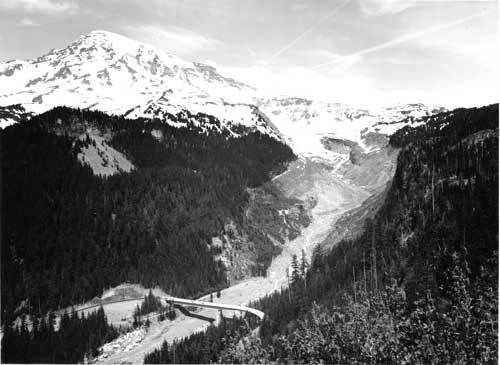
| Mount Rainier and Nisqually Glacier from Canyon Rim, 1962. The glacier-clad volcano is both a natural attraction and a public safety and engineering concern. Note the old road cut to the site of a former bridge which was repeatedly washed out by glacial outburst floods. (Art Harrison photo courtesy of Mount Rainier National Park.) |
USGS monitoring of the volcano began in the 1960s with the taking of aerial photographs and infrared images of Little Tahoma, the South Tahoma and Emmons glaciers, and the summit craters, and the installation of seismographs at various points on the mountain. USGS geologist Robert M. Moxham made infrared surveys of the summit in September 1964, September 1966, and July 1969, and USGS geologist John D. Unger measured microearthquakes beneath Mount Rainier in 1968 and 1969. [39] After 1980, the USGS upgraded its monitoring capabilities under the agency's new Volcano Hazards Program. The volcano watch now included the use of laser-ranging devices which could detect subtle changes of shape or bulges in the mountain caused by magma rising, and the monitoring of gas emissions from the summit crater. [40]
In addition to monitoring the volcano, USGS scientists worked with the park administration on hazard assessment and emergency plans. Dwight R. Crandell of the USGS prepared the park's first planning document of this nature in 1967. Crandell's report described the warning signs of an impending eruption, recounted the various effects that might be expected from a volcanic eruption and what areas of the park they would most likely impact, and listed evacuation routes. Crandell included a table indicating the level of hazard from these different effects for all the development sites in the park. White River and Tahoma Creek campgrounds both rated "high" in most categories; Crandell indicated that the latter was "in an especially hazardous location." As for evacuation routes, these were not always by the most direct route away from the volcano. To evacuate the Longmire and Cougar Rock campgrounds, for example, it would be necessary to use the Skate Creek Road in the event that the bridges at Kautz Creek or Tahoma Creek were destroyed. If the one-lane bridge over the Nisqually River at Longmire were washed out, it would be necessary to drive toward the mountain in order to leave the park via Stevens Canyon. [41] The director of the USGS transmitted Crandell's report to the director of the NPS with the comment that the potentially alarmist report would not be publicized by the USGS. [42] (Another evacuation plan, prepared by the Park Service's Edward L. Parsegan in 1969, did not brighten the picture significantly.) [43]
With the designation of Mount Rainier as a Decade Volcano in 1992, scientific interest in the mountain intensified. The purpose of the IAVCEI's Decade Volcano program was to concentrate scientific research on a few "Volcano Demonstration Projects" with the hope of learning lessons that would reduce the social effects of natural disasters. Mount Rainier was selected for a combination of reasons including its proximity to large population centers, its volume of snow and ice (which raised the potential for large-scale mudflows), the steepness and instability of its cone, and its recent eruptive history and seismicity. "Despite such hazard and risk," three Mount Rainier scientists pointed out, "Mount Rainier has received little study; such important topics as its petrologic and geochemical character, its proximal eruptive history, its susceptibility to major edifice failure, and its development over time have been barely investigated." [44] Geologic research definitely had the potential to assist park managers in protecting the public, even within the confines of the park.
By 1993, a dozen separate geologic investigations were underway in Mount Rainier National Park: five by the USGS, one by the Environmental Protection Agency, and six by universities. [45] As the research continued, park personnel worked with federal, state, and university geologists to enhance monitoring, coordinate research, and translate these efforts into a comprehensive disaster-response plan. The findings, it was expected, would be incorporated into the park's new general management plan.
| <<< Previous | <<< Contents>>> | Next >>> |
adhi/chap21.htm
Last Updated: 24-Jul-2000