|
MOORES CREEK
Master Plan |

|
PLAN
CIRCULATION
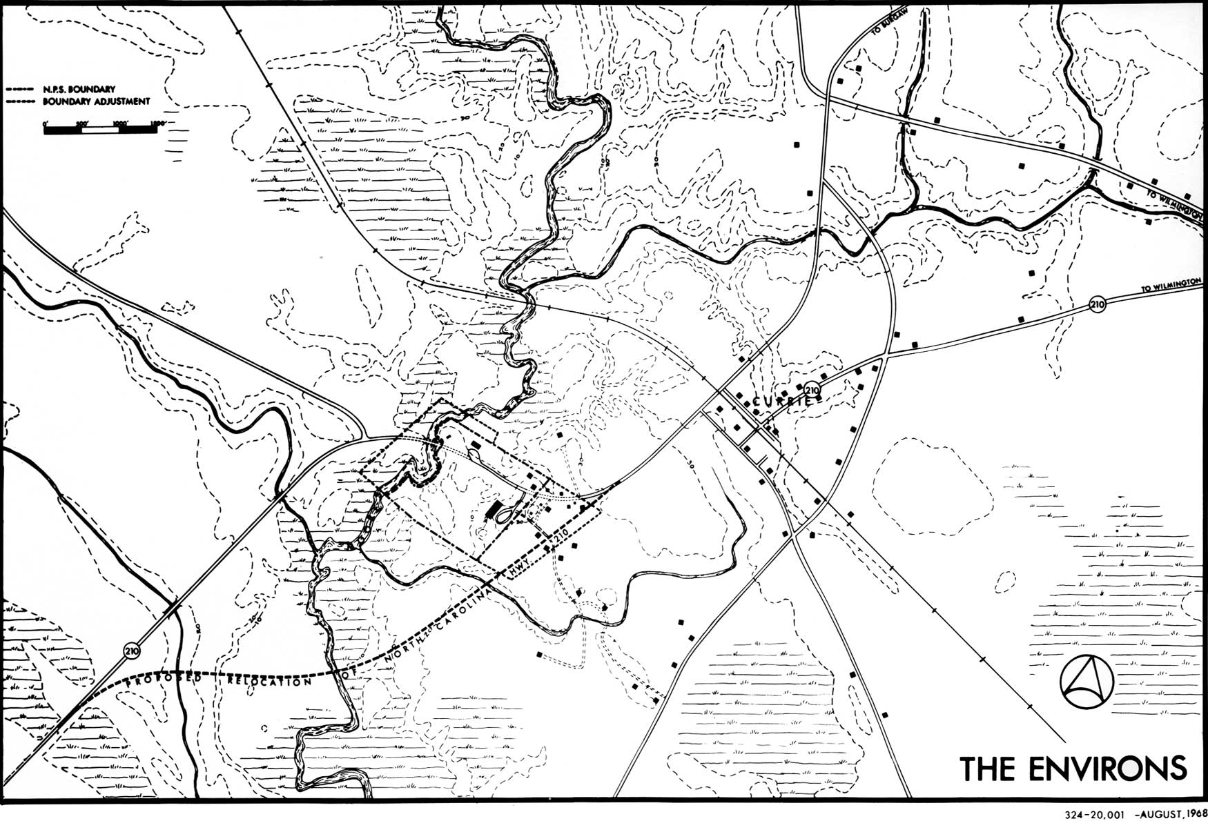
The present alignment of North Carolina 210 through the park has proven to be a safety hazard for pedestrians within the park and vehicles entering and leaving the park facilities. The intrusion of visual and noise interference has hampered effective interpretation. Also, the State Highway Department had planned to reconstruct the bridge across Moores Creek, raising its level some 8.5 feet, which would have created an intolerable visual intrusion on the historic scene and intensified the existing problems.
To resolve this situation, the State Highway Department has agreed to build a bypass around the park to the east and south (see letters, Appendix B).
Entrance
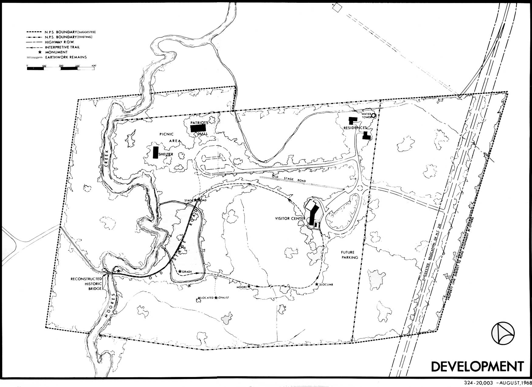
The visitor travelling to the park over the new road will enter a deceleration lane and then make a safe turn onto the park entrance road, which terminates at the visitor center parking area.
With the realignment of N.C. 210 and a new entrance road, the present western entrance will be abandoned and the bridge across Moores Creek will be demolished. At this time the highway fill can be placed in the artificial creek bed which the bridge now crosses and the area restored to its original appearance. Likewise, the present eastern entrance can be eliminated.
Interior
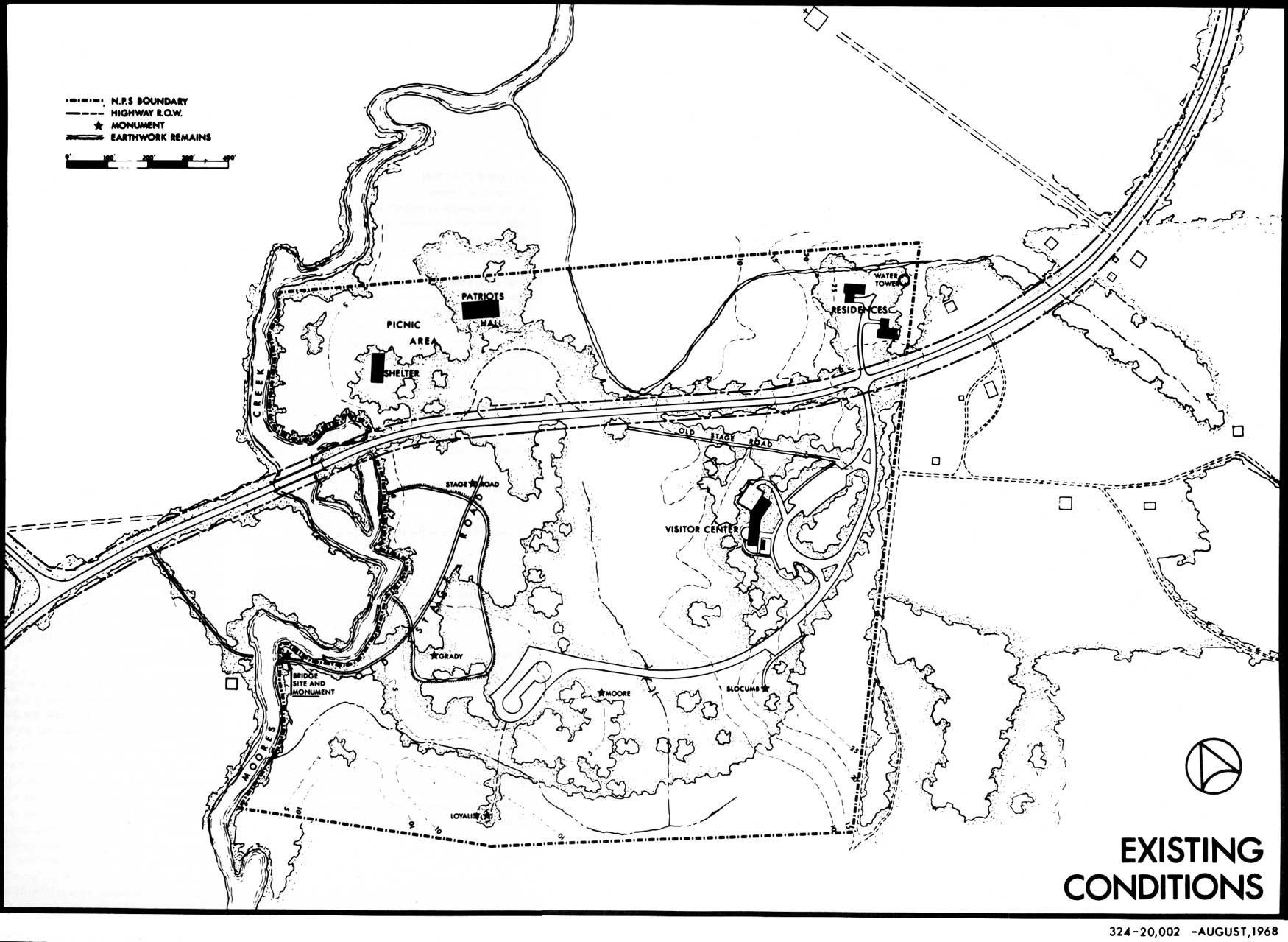
That portion of old N.C. 210 between the visitor center and the picnic area and Patriots Hall. The Patriots Hall parking area will be redesigned for convenient turning. The existing post and rail fence along N.C. 210 can be reshaped to mark the parking area limits. No expansion of the picnic area is expected to be necessary except possibly the adding of a few tables.
The paved road from the visitor center to the earth-works and the two parking areas along it will be removed due to its encroachment on the historical scene and the relatively short walk does not require these facilities. Removal of these parking spaces may eventually necessitate an expansion of the parking area at the visitor center.
LAND ACQUISITION
In 1944, the Congress of the United States authorized the Secretary of the Interior to accept property by donation for Moores Creek National Military Park, not to exceed 100 acres. Under this authorization 12.23 acres were added to the park in 1953, leaving 87.77 acres available for acceptance by donation. It is recommended that a minimum of approximately 35 acres be acquired in fee and added to the park, located as follows:
East of the Park
Approximately 21 acres will be added to provide for an audio and visual buffer from through traffic. The State Highway Department will be given a right-of-way to relocate N.C. 210 through this tract thus providing for roadside and traffic control as visitors approach the park entrance. Also, there would be available space for future expansion of parking and maintenance facilities should the need ever arise.
This area is now farm and fallow land; it contains several residences and outbuildings and a tiny country store. There is one tobacco allotment. Until required for development, this land could continue in agriculture through lease-back or special-use permit.
West of the Park
A minimum of 12 acres will be purchased for interpretation and preservation of the historic resources and to provide a visual barrier against possible future developments outside the park. Historic resources preserved include a portion of the historic trace leading from the bridge site and the site of Caswell's camp.
This is all woodland, some swampy, and west of the historical bridge site is a small concrete block "fishing camp" and artesian well.
|
| The Environs. (click on image for an enlargement in a new window) |
|
| Existing Conditions. (click on image for an enlargement in a new window) |
North of the Park
Patriots Hall was erected only 60 feet from the park boundary, leaving it with little protection against visual encroachment from adjacent property. Enough land (about 2 acres) will be added to allow for a 150-foot vegetative shield from the adjoining property. This strip is extended to the creek in order to protect against fish camp or similar incompatible development in this vicinity.
This area was an open field years ago. It now supports a dense growth of trees and shrubs.
Present Land Use
All lands presently within the park were purchased by North Carolina and donated to the Federal Government. However, in 1967 when the State was approached concerning purchase of land west of the creek, it expressed a greater immediate commitment for State parks. If their is no other source for donation, the Service will need to seek legislation to allow the Federal Government to purchase the land. When the legislation is written, an approximate acreage should be given so as to allow for possible severance problems. An early target date for the purchase should be established since the State Highway Department indicates that the present N.C. 210 bridge across Moores Creek could be unsafe after 5 to 7 years. Park development should be concurrent with highway improvements and both should be completed prior to the bicentennial of the battle in 1976.
|
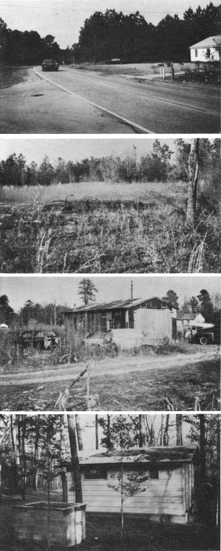
| TOP TO BOTTOM: State highway 210, near the park's eastern boundary. General characteristics of the unimproved land which will be acquired east of the park. An auto repair shed on land proposed for acquisition east of the visitor center. A private cabin on land just west of the bridge site. |
INTERPRETATION
Interpretive Theme
While the Battle of Moores Creek provides a dramatic high point of the interpretive story, the causes for, and the long-term results of the engagement are of primary significance.
The park interpretive theme is then threefold: (1) the complex clash of loyalties and cultural backgrounds that created factions so strong they were willing to defend their convictions with military action; (2) the military campaign and troop movements that led to and included the battle at Moores Creek Bridge, a brief but decisive victory for Patriot arms; and (3) the results of the action, including the immediate thwarting of the British Carolinas campaign, and the creation of an important link in the chain of events that would end in victory for the cause of American independence.
Interpretive Method
The cause and results of the battle will be presented in the park visitor center, and the battle itself will receive attention in the field on the actual site.
Visitor Center
Museum exhibits are arranged in an orderly sequence and designed to provide background and effects of the battle. Since visitors to Moores Creek do not usually arrive in large numbers and they are not pressed for time, this exhibit technique is acceptable. Certain modifications to make the exhibit series more effective are advanced in a current and approved interpretive prospectus.
There is a great need for a good sales publication, such as a historical handbook and/or a source book, for those who wish more detailed material on the subject. When the park minifolder is completed, the present free folder will become a low-cost sales item. The minifolder should be designed to help solve the area's publicity problems and provide easy directions to the park, which is located off the beaten path.
Field Interpretation
With the exception of personal services provided for groups, the battlefield tour will be self-guiding. This tour will be developed on a new trail, which will present the story in a more logical and meaningful order. A complete tour will be 2500 feet in length and free of the present intrusion of automobiles and roads. All conflicting roads and trails will be eliminated.
The interpretive trail will leave the visitor center viewing terrace and intersect the historic road in the vicinity of the State Road Monument. Between these two points, the trail will be crossing a mowed lawn but a barrier of native vegetation should be allowed to shield the trail from the picnic area and its access road.
From the State Road Monument, one will walk through the Patriot earthworks remains to the bridge site. The area adjacent to the road and outside the earthworks will be allowed to reforest. This will help create a receptive mood, as well as give the visitor somewhat of an idea of the area's 1776 appearance. Along the trail, a variety of interpretive media will be used to build the battle story to its climax at the restored bridge. From a viewing station within sight of the bridge, a stereo-audio program as outlined in the interpretive prospectus will reenact the battle.
Since Moores Creek is a navigable stream it would be necessary to secure a permit from the U. S. Coast Guard in order to restore the historic bridge (see Appendix B).
When the visitor returns to the Patriot earthworks, he may continue his tour by following the trail passing the relocated Loyalist monument, the James Moore, and Mary Slocumb monuments and on to the visitor center.
Patriots Hall
This structure is primarily a picnic shelter suited for use all year. It also contains restrooms and a small meeting room where patriotic meetings are held occasionally. This room could also be used for movie programs for school groups which could augment the interpretation of the battle and the Revolutionary War or relate to environmental education.
Historic Bridge
Fishermen in rowboats powered by outboard motors occasionally use Moores Creek adjacent to the park. Being a navigable stream, its bed is owned by the State. Moores Creek, at the historic bridge site, has a tidal fluctuation of 2- to 2-1/2-feet. Before the historic bridge can be restored, application for a permit must be made to the U. S. Coast Guard. The procedure for obtaining a permit is outlined in a letter from the U. S. Coast Guard's Fifth District Officer in Portsmouth, Virginia. (See Appendix B). When the Service decides to proceed, it should discuss the project informally with the U. S. Coast Guard to avoid possible embarrassment to either agency if a permit could not be issued as requested in the formal application.
PUBLIC RELATIONS
Since the park is in an area where main transient transportation routes do not exist, visitation to the park originates from the local population or those people spending a vacation within 25 miles of the park. This fact and the remoteness of the park in relation to a seashore recreation populus makes it obvious that a strong public relations program must be developed. This should be oriented primarily to the Wilmington and beach resort areas. This would involve the presentation of talks to adult and school groups and the distribution of minifolders through the Chamber of Commerce, motels and at other sites which attract visitors. Assistance of the Moores Creek Battlefield Association should be sought in this endeavor so as to supplement the efforts of the park staff in developing a public awareness of the park's existence and significance. This is not to be a mass-advertising campaign to draw thousands of uninterested spectators. It should be aimed towards informing the public that a historically unique area exists within 25 miles of their temporary or permanent residence.
|
| Development. (click on image for an enlargement in a new window) |
MANAGEMENT
Fire Lanes
Fire lanes shall be cut and maintained around any new boundaries. These will be of the same caliber as those presently maintained around the existing property lines and the old fire lanes should be allowed to revegetate in woodlands.
Erosion
Erosion of the trails due to flooding will be controlled as it is presently through the use of soil cement in the gravel surface of the trails.
The Aerial Power Lines
The aerial power lines that parallel N. C. 210 through the park are presently a visual intrusion and perhaps will be worse when the highway is eliminated. The lines should be removed, and since the special use permit to the Four County Electric Membership Corporation expires in March 1970, this may be the best time to deal with the problem.
Carrying Capacity
Ideally all visitors to Moores Creek National Military Park would begin their visit to the area at the visitor center. This being the case the visitor center becomes the limiting facility in figuring the carrying capacity of the historical portion of the park. The visitor center can comfortably accommodate approximately 50 visitors at one time. If their stay is 20 minutes, then the building will easily carry 150 persons per hour. The visitor center can physically handle a larger number than 150 per hour; however, if this occurs there will be crowding in the museum and the quality of the experience will decrease.
The picnic area with 20 tables will accommodate 80 persons at a single time. Rarely would there be this many people using these facilities, but if future demands become greater, there is sufficient space to provide additional tables.
Road Resurfacing
Road resurfacing when necessary will be asphalt with a washed pea gravel rolled into the finished surface so as to create a less obtrusive appearance.
Vegetative Treatment
In order to develop a logical and meaningful experience for the visitor, careful attention will be given to the treatment of park vegetation.
To the east of the relocated Route 210, the fields will be allowed to reforest so as to provide a dense visual barrier. To the south of the proposed entrance road, an open field, with a few specimen trees on its periphery, shall be maintained. This will enable the visitor to orient himself in his approach to the visitor center. This field will be mowed once during the year so as to maintain a hayfield appearance. The north side of this road will be allowed to revegetate naturally in order to direct the view towards the visitor center.
The present open space, as viewed from the terrace of the visitor center, will be maintained through pruning of the trees and routine mowing. To eliminate vehicular distraction, a dense buffer will be allowed to revegetate between the trail and the road to the picnic area. In order to create a logical transition between the manicured open space and the historic scene, the wooded area between the earthworks and the mowed area to the east will be allowed to develop an understory. Periodically this will be cut selectively to avoid a jungle appearance but it shall not be mowed. The visitor should not be able to see the visitor center from the earthworks. The area within the earthworks and the field of fire to the bridge shall be maintained, as near as it can be determined, to its appearance in 1776.
As the visitor leaves the earthworks, he will experience the same vegetative transition in that the trail will be enclosed by a tree canopy between the earthworks and the open space. The remainder of the park shall be allowed to revegetate naturally. The tree lines, as indicated on the development plan, will be used as a guide for mowlines.
Land Classification
The historic lands, those where the battle took place and where the troops maneuvered, have been designated Class VI. It is in this zone that everything possible will be done to recreate the 1776 appearance in accordance with the interpretive prospectus.
The Class III zone perpetuates or re-establishes natural conditions to provide a setting or atmosphere in keeping with the 1776 conditions. In some places, Class III serves as a screen or insulation from external influences; it will include woodland, swamp and savannah, as appropriate.
In the Class II zone are all areas developed for visitor accommodation with sufficient space allowed for possible future need, and relocated North Carolina 210, because it is a segment of a commercial highway. A minimum of 150 feet east of the centerline is considered essential for environmental control.

|
| Land Classification. (click on image for an enlargement in a new window) |
Priority of Needs
Land acquisition is of first priority and it is required in order to relocate North Carolina 210, to provide environmental protection and to preserve more of the historic site. Following acquisition, several intrusions will be removed and the setting for the field interpretive program will be improved.
The timing of the development at Moores Creek is critical, for the North Carolina Highway Department has indicated that the present N. C. 210 bridge across Moores Creek will become unsafe in 5 to 7 years. This means that the highway relocation should be completed before that time.
The bicentennial of the battle will be celebrated in 1976. The Service should complete its development by this date.
| <<< Previous | <<< Contents>>> | Next >>> |
master_plan/sec4.htm
Last Updated: 07-May-2007