|
MAMMOTH CAVE
Master Plan Preliminary Draft |

|
THE VISITORS
WHERE DO THEY COME FROM?
A recent survey shows that 71 percent of the park's visitors originate within Kentucky and the four heavily industrialized and urbanized States to the north. This is the "Travel Influence Area" shown on the accompanying map.

Cities and Population
| Akron, Ohio | 605,367 | Greenville, S. C. | 255,806 | |
| Atlanta, Ga. | 1,017,188 | Indianapolis, Ind. | 916,932 | |
| Birmingham, Ala. | 634,864 | Knoxville, Tenn. | 368,080 | |
| Charlotte, N. C. | 316,781 | Little Rock, Ark. | 242,980 | |
| Chattanooga, Tenn. | 283,169 | Louisville, Ky. | 725,139 | |
| Chicago, Ill. | 6,220,913 | Madison, Wis. | 222,095 | |
| Cincinnati, Ohio | 1,268,479 | Memphis, Tenn. | 674,583 | |
| Cleveland, Ohio | 1,909,483 | Milwaukee, Wis. | 1,232,731 | |
| Columbus, Ohio | 754,924 | Nashville, Tenn. | 463,628 | |
| Davenport, Ia. | 319,375 | Peoria, Ill. | 313,412 | |
| Dayton, Ohio | 727,121 | Pittsburg, Pa. | 2,405,435 | |
| Detroit, Mich. | 3,762,360 | St. Louis, Mo. | 2,104,669 | |
| Grand Rapids, Mich. | 461,906 | Toledo, Ohio | 630,647 |
Higher population densities and higher median incomes may account for the imbalance of northern visitation. Moreover, some of this northern population migrated from Kentucky and Tennessee and many of them return to their homes to spend their vacation time. Visitors are also attracted to central Kentucky and Tennessee because of large reservoirs and mountains not available to the north.
The 8-hour travel line shown on the map indicates one day's average travel time from the park. Most major metropolitan areas to the north are at such a distance from south central Kentucky that visitors require overnight accommodations. Completion of the Interstate Highway System will provide an expanded time-distance line, but most travelers will still be a day's drive, or more, from the park.
The north-south travel corridor was established early in the 19th century with the construction of the Dixie Highway (now U.S. Highway 31W). This has been upgraded continually over the years and is now paralleled by Interstate Route 65 from Chicago to Mobile. The Louisville-Nashville Railroad, built in the mid—19th century, also traverses this corridor.
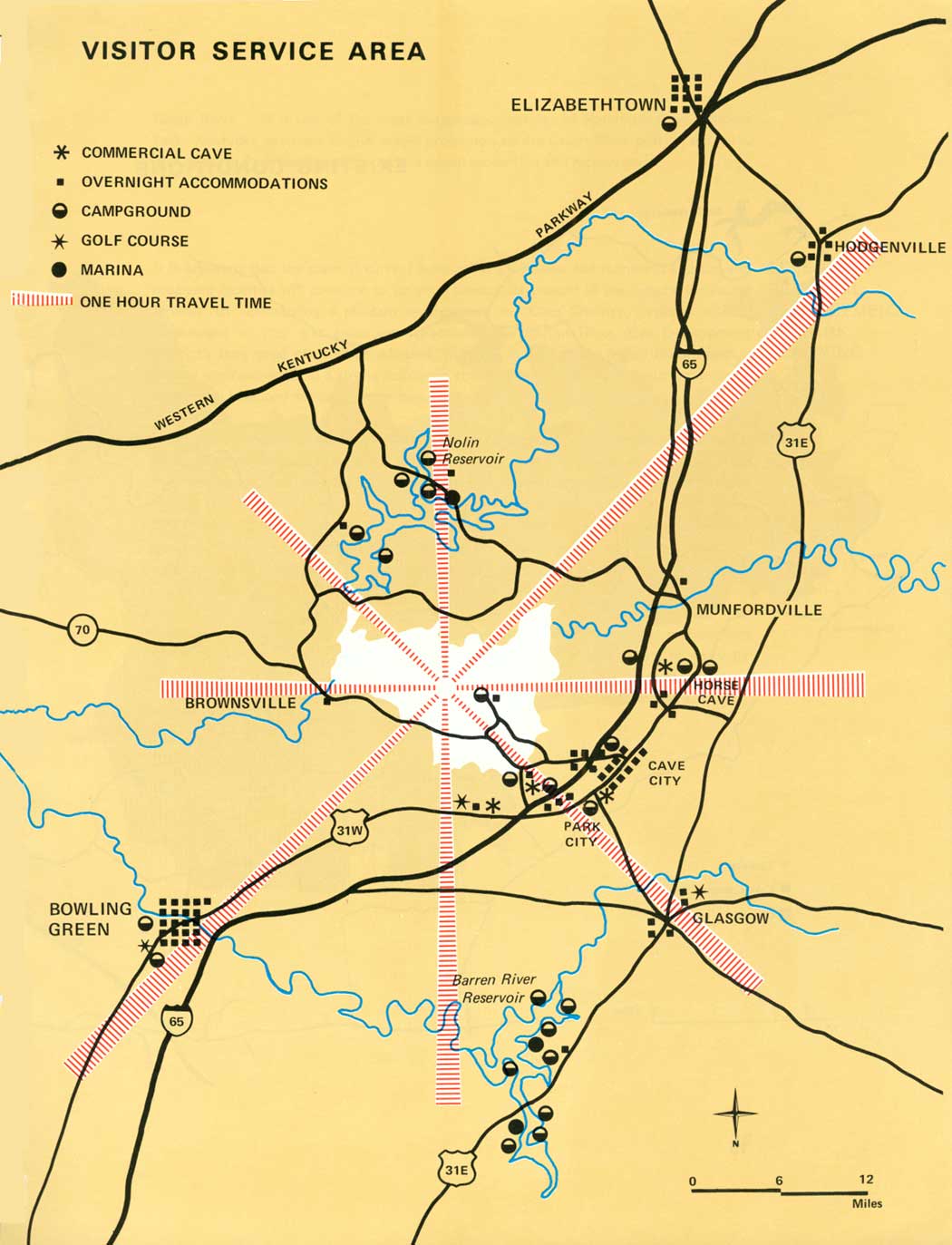
VISITOR SERVICE AREA
The caves of "Cave Country," the north-south travel corridor, State parks, two Corps of Engineers' reservoirs, and the national park have resulted in a concentration of visitor services within an hour's drive of park headquarters.
Since the early 1940's, when Mammoth Cave gained recognition as a national park, the tourist industry has expanded to meet visitor demands. The 1966 Copeland Travel Survey of Kentucky disclosed that one-third of the retail business firms in "Cave Country," employing 4,057 persons, had receipts of $53 million, $15 million of which was spent by tourists from other States. The $53 million ranked tourism third, as an economic unit, behind manufacturing ($67 million) and agriculture ($84 million).

|
| Relationship of Visitor Service Areas to Other Study Areas. |
Much of this tourism industry is clustered around the main access routes to Mammoth Cave National Park, in the towns of Cave City and Park City, where there are numerous motels, campgrounds and visitor attractions. Most of these facilities were constructed during the last 3 years and were generated by increasing travel to the park during the 60's and promise of better access provided by the Interstate Highway System.
Another impact of the park on the region has been the shortening of time people stay in the park. Years ago, most visitors stayed overnight; now the average visitor spends 3 to 4 hours. Within the Visitor Service Area, private enterprise is upgrading its attractions and accommodations and encouraging visitors to stay longer in "Cave Country."
The Service Area does not add significantly to the park's visitation. Population density is low (48 persons per square mile) and has remained stable for the past 20 years. Only 25 percent of the population is considered urban and no significant increase in urbanization is expected before 1980.
The Visitor Service Area mostly lies within the newly formed Barren River Area Development District (BRADD) which was established by the Commonwealth in cooperation with the Economic Development Administration of the U.S. Department of Commerce. The purpose of the District is to upgrade the economy of the area by securing funds for specific development projects. This District contains 10 counties surrounding the park. Under State enabling legislation, a council is responsible for planning land use and public facilities. A planning staff has been hired and local support for the council appears to be strong. This council provides an excellent vehicle for joint regional planning and the National Park Service is represented on it.
Within the Visitor Service Area are three fast-growing cities — Elizabethtown, Glasgow and Bowling Green — and Nolin and Barren Reservoirs constructed by the Corps of Engineers. On both reservoirs are boat ramps, marinas and campgrounds and on the Barren River Reservoir a State resort park is being developed by the Commonwealth. It will consist of a full range of overnight accommodations, golf course, swimming pools, marinas, and other amenities designed to cater to the out-of-state traveler. Just outside the Visitor Service Area, similar resort park developments are underway on the Rough River and Green River Reservoirs. Much of the private land surrounding each of the reservoirs is being sold for vacation home sites which will add another dimension to the regional economy.
The Corps of Engineers has invested $960,000 in recreational development on the Nolin and Barren Reservoirs since 1960, and expects to double the capacity of most of these facilities in the near future because of heavy visitation.
In 1969, there were 58 motels providing 2,300 units (average unit, two double beds) and 25 campgrounds providing 7,633 campsites within the Visitor Service Area. Many of these are located on the established north-south travel corridor which facilitates their use by the through traveler. Occupancy rates for the motels and private campgrounds are not available.
Within 1/2 hour from the park, there are six, small privately-owned commercial caves which generally feature dripstone and flowstone formations on 1-hour guided tours which seldom exceed 25 people in a group. Commercial caves usually remain open in the late afternoon after the park caves are closed and some provide evening tours. All caves are open throughout the year. Colored lights illuminating the dripstone and flowstone formations produce an artificial appearance, but it is generally done in good taste and provides a contrast to the white light used in Mammoth Cave. Interpretation in commercial caves is generally limited to the personification of the formations by the guide. Nevertheless, the visitor has a unique and somewhat mystical experience which is a good contrast to cave trips in the park.
Other tourist attractions in the Visitor Service Area include the Abraham Lincoln Birthplace National Historic Site and Western Kentucky University. Affording somewhat unique experiences for visitors are the oil fields in Green County and tobacco auctions during December and January (there are 25 tobacco warehouses in the area). Outside of the 1-hour travel time, but close enough to be considered attractions, are My Old Kentucky Home State Park at Bardstown, the 10,000-acre Bernheim Forest and Arboretum northwest of Bardstown, and the reconstructed Shaker Village in Auburn.
|
| Visitor Service Area. (click on image for an enlargement in a new window) |
Other influences of the region on the park come in the form of State and Federal projects:
Mammoth Cave Parkway Two miles of State 255 from the park boundary to its interchange with I-65 were reconstructed by the Commonwealth in 1969. A 500-foot wide right-of-way was purchased to maintain the scenic quality and access has been limited to three points, resulting in an attractive approach to the park. Projected traffic at the I-65 interchange is 15,000 average daily units by 1975.
Interstate Highway 65 When completed between Louisville and Nashville in 1971, these two cities and their 1.5 million people will be within 2-hours travel time of the park via I-65. One-quarter of the U.S. population will live within 500 miles of the park upon completion of the Interstate Highway System in the mid 70's.
Owensboro-Bowling Green-Somerset Toll Road This proposed road, in combination with an upgraded State 70, will improve east-west circulation through southern Kentucky into "Cave Country" and will place the Corps of Engineers' Green and Rough River Reservoirs within 90 minutes travel time of the park. Nolin and Barren River Reservoirs are much closer. Planned public use facilities when completed around these four reservoirs will probably attract many tourists on a long-term basis. All told, there will be 15,375 feet of bathing beaches which will accommodate 10,000 swimmers per day, three major State-operated resort parks, six marinas, numerous boat ramps to accommodate 3,700 boats per day, and 1,628 formal campsites. Development of this new travel corridor will also have an enormous impact on counties such as Edmonson and visitor attractions such as the Nolin Reservoir which heretofor have been "off the beaten path."
Green River It is one of the most outstanding features of Mammoth Cave National Park. Kentucky proposes to give scenic protection to the Green River outside the park. The National Park Service welcomes this added protection and recognition.

|
| Existing Conditions. (click on image for an enlargement in a new window) |
EFFECTS OF REGIONAL DEVELOPMENT ON PARK PLANNING
It is apparent that the scale of current development is intense and numerous existing and proposed facilities will combine to satisfy a substantial amount of the demand for visitor services. By maintaining a pleasant environment in "Cave Country," visitors will be encouraged to stay and enjoy its attractions. The Barren River Area Development District's long-range plan, when adopted, will help in guiding the region toward both a quality environment and a strong economic structure by combining the tourism industry with a well balanced mixture of non-seasonal industry.
Years ago the visitor to Mammoth Cave reached it after a long and tedious journey which required a rest period or vacation. At that time the cave was a destination and in most cases the sole purpose for the trip. During the past 25 years the tourist has become more mobile and the park is no longer an exclusive destination area. Moreover, the intensity and scope of development outside the park makes it obvious that overnight accommodations are no longer needed within Mammoth Cave National Park. Thus, the park should fill a day-use need and allow private interests in the Visitor Service Area to provide lodgings.
Also, since most visitors approach Mammoth Cave from the primary travel corridor east of the park, the point of departure for cave trips within the park should be mutually accessible to the cave and to the corridor. To meet these criteria, the point of departure, or staging area, should be located peripherally at the southeast corner of the park.
| <<< Previous | <<< Contents>>> | Next >>> |
maca/master_plan/sec1.htm
Last Updated: 15-May-2007