|
|
Oahe Reservoir Archeology, Geology, History> |

|
THE LEWIS AND CLARK EXPEDITIONS
The long and dangerous journey to the Pacific Ocean by Captains Meriwether Lewis and William Clark is one of the most striking episodes in the exploration of the west. The Lewis and Clark Expedition has become an important part of our national heritage, yet the significance of the journey, its purpose, its trials and successes, have not always been appreciated.
The assertion of American sovereignty over the vast area of Louisiana, purchased from France in 1803, was of great importance, but the contracts with the native peoples, the records, maps, and collections of objects made by the travelers were also of lasting significance. Traders and adventurers of various sorts had already covered much of the route up the Missouri, but their travels were little known. The Lewis and Clark Expedition, on the other hand, had a tremendous impact upon the public mind and has continued to be of importance to scientists and historians for more than one hundred and fifty years.
The expedition, following President Jefferson's orders, was to ascend the Missouri River to its headwaters and, moving westward, to determine whether the Columbia, the Colorado, or perhaps some other river might provide an economical feasible route to the Pacific coast. Further, the explorers were to study the Indian tribes, the topography and the flora and fauna of the country through which they traveled.
The "Corps of Discovery" sailed from Wood River, a short distance from St. Louis, on May 4, 1804. Keelboat travel up the Missouri, with its trecherous snags, shifting channel and dangerous sand bars was difficult and slow. It was not until late September that the party approached the section of river that was to become the Oahe Reservoir.
|
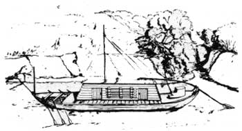
| The keelboat or mackinaw, capable of carrying as much as 30 tons of freight, was the first important work boat on the Missouri. The Lewis and Clark Expedition used such a vessel in 1804 and, although it became less important after the appearance of the steamboat, in the 1830's, the keelboat continued in use for many years. Photo: Courtesy of the Missouri Basin Project, Smithsonian Institution |
On the evening of Monday, September 24, the explorers anchored just off the mouth of a considerable river which they named the Teton (the modern Bad River) after the Teton Dakota peoples they met in the vicinity. The following morning, with a flagstaff and awning erected especially for the purpose, the party played host to a large group of the Teton who were camped nearby. At first all went well. A flag of the United States, a medal, a lace-trimmed uniform coat and other presents were distributed and the chiefs were invited on board the keelboat. There, a very powerful airgun owned by Captain Clark was demonstrated,
"and such curiosities as we thought might amuse them: in this we succeeded too well; for after giving them a quarter of a glass of whiskey, which they seemed to like very much, and sucked the bottle, it was with much difficulty that we could get rid of them. They at last accompanied Captain Clark on shore in a periogue (or dugout canoe) with five men; but it seems they had formed a design to stop us; for no sooner had the party landed than three of the Indians seized the cable of the periogue, and one of the soldiers of the chief put his arms round the mast: the second chief, who affected intoxication, then said, that we should not go on, that they had not received presents enough from us ...
(The Lewis and Clark Expedition, by Meriwether Lewis, edited by Archibald Hanna, Vol. I, pp. 72-73; J. B. Lippincott Co., 1961).
Captain Clark drew his sword, the swivel gun aboard the boat was manned, and the party prepared to defend itself. Apparently the determination to meet force with force had its effect. The leaders of the Teton had an immediate change of heart. Peaceful overtures were made and the next day the explorers were entertained by a dance and a feast which incidentally included dog meat stew, a favored dish among the Sioux. While Lewis has left us a colorful account of the celebration, one feels that the explorers were still ill at ease. The Teton had created an unfortunate impression, an impression shared by the sedentary farming peoples the travelers were soon to encounter in the north.
The explorers extricated themselves from the Teton with difficulty, and sailed on into the Oahe Reservoir area. The succeeding days were filled with problems—high winds, an unknown channel, and the trials of day to day existence—but there was no immediate threat from the Indians. By October 1, the party had passed the mouth of the Cheyenne River, not far from which they met a Mr. Valle and another young Frenchman who were trading with the Indians in the area. During the following week there were Indian alarms and the weather worsened but the party continued to make good progress toward their goal. The travelers were now in Arikara country. The remains of their abandoned villages were numerous along the river banks and even on some of the larger islands.
On Ashley Island, above the mouth of the Grand River, the party came to the first of the three inhabited Arikara towns:
"—we reached an island close to the southern shore, from which it is separated by a deep channel of sixty yards. About half way a number of Ricara Indians came out to see us. We stopped and took a Frenchman on board, who accompanied us past the island—. Captain Lewis then returned with four of the party to see the village; it is situated in the center of the island, near the southern shore, under the foot of some high, bald uneven hills, and contains about sixty lodges. The island itself is three miles long, and covered with fields in which the Indians raise corn, beans, and potatoes". (ibid., p. 88).
On Wednesday, October 10, following a day of bad weather, the Captains sent
"Mr. Gravelines, who with Mr. Tabeau, another French trader, had breakfasted with us, to invite the chiefs of the two upper villages to a conference. They all assembled at one o'clock, and after the usual ceremonies, we addressed them in the same way in which we had already spoken to the Ottoes and Sioux: we then made or acknowledged three chiefs, one for each of the three villages; giving to each a flag, a medal, a red coat, a cocked hat and feather, also some goods, paint and tobacco, which they divided among themselves: after this the airgun was exhibited, very much to their amusement—." (ibid., p. 89)
The next morning, the council again convened, the Arikara promised friendship, and following a further exchange of gifts the party moved northward to the other two villages. Again, there were predictable delays, for speeches, discussions, and the exchange of gifts, but by mid-afternoon of the following day the explorers were on their way northward. Their experiences among the Arikara were in sharp contrast to their visit among the Dakota. While it wasn't to last, the Arikara were left as firm friends of the White man.
|
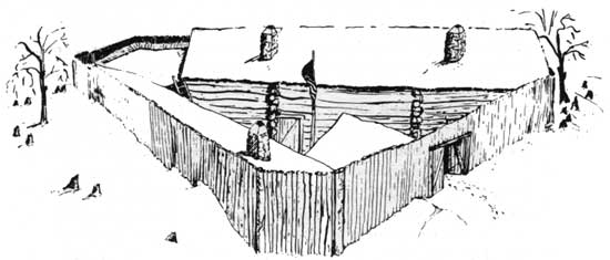
| Artist's reconstruction of Fort Mandan, built by the Lewis and Clark party for winter quarters, 1804-1805. The reconstruction is based upon a description by Sgt. Patrick Gass, and a woodcut probably made from a picture drawn by him. The post was so strongly built that a trader from Canada thought it "almost cannon ball proof." Photo: Courtesy of the Missouri Basin Project, Smithsonian Institution |
The expedition continued on its way, hastening toward the Mandan country in the face of approaching winter. Game was abundant and, despite deteriorating weather, progress was rapid. By late October, the Mandan communities in the vicinity of modern Bismarck had, been reached, and by November 3 the first timbers were cut for the construction of Fort Mandan, the wintering house for the expedition. It had required six months to ascend the river this far; another year was to pass before the travelers reached the Pacific and most of another before they again returned to St. Louis and civilization, thus ending one of the epic journeys of the early west.
| <<< Previous | <<< Contents>>> | Next >>> |
sec4.htm
Last Updated: 08-Sep-2008