|
Kenai Fjords
A Stern and Rock-Bound Coast: Historic Resource Study |

|
Chapter 5:
BUILDING THE TRANSPORTATION INFRASTRUCTURE (continued)
Shipping Activities Along the Kenai
Coastline
Prior to 1900, little commercial shipping took place along the southern Kenai Peninsula coast. Between 1900 and 1920, the only significant non-Native population cluster was located in Seward, where economic activities centered on railroad construction. As a result, much of the shipping that took place along the Kenai coast centered around the movement of railroad workers and supplies. After the railroad was completed, coastal shipping served a variety of economic activities. Both ocean liners and smaller boat service connected Seward with various Cook Inlet communities, Kodiak Island communities, and points "to the westward:" the Alaska Peninsula, Aleutian Islands and Bristol Bay. Most of the traffic along the southern Kenai coastline was going to or from Seward. On occasion, however, ships sailing more distant routes sought out the shelter of the Kenai's bays and coves during stormy periods, and some of those ships anchored there for fairly extended periods.
Ships have likely ridden out storms in refuges along the Kenai coast for hundreds of years; Natives, Russians, and perhaps other European explorers have all doubtless taken advantage of the many irregularities along the coast for that purpose. Perhaps the first recorded instance of shelter-seeking took place in 1896, when a party of miners, one of whom was George Stinson, was blown off course on its way to the Hope and Sunrise gold camps. A news report, printed years later, noted that on a westbound trip from Kayak Island toward the gold camps, the miners became so seasick that they decided to hove-to in Nuka Bay and rest for a few days. Rich-looking float [9] was picked up on the beach, but the miners were more interested in the rich Hope placer diggings, so little attention was paid to their find. [10]
During the Klondike gold rush of 1897-98, one of the major routes that took stampeders to the gold fields was the so-called "rich man's route" that connected Seattle to St. Michael by way of Unalaska. Some of the ships that plied this route followed a more-or-less direct line between Seattle and Unalaska, and this route took stampeders hundreds of miles away from the Kenai coastline. But during the summer of 1897, when the gold-rush frenzy was at its highest, a number of vessels which were clearly unseaworthy were hauled out of retirement for the voyage north; many of these craft, for reasons of safety, took a more circuitous coastal route. [11] That winter, the Moran Brothers Company began constructing twelve nearly identical riverboats in its Seattle shipyards. They were completed in May 1898, after which the company attempted to sail them to St. Michael for use along the Yukon River. The shallow-draft boats were unprepared to travel in the stormy seas of the Gulf of Alaska, so they skirted the coast as much as possible. [12] Despite their caution, a storm on June 23 forced the fleet to retreat to an unknown cove in Nuka Bay. As noted in the diary of an unidentified carpenter who sailed on the steamer Seattle,
Thursday, June 23. The signal was flying on board the Pilgrim "make for shelter," and the fleet turned off of the course it was taking. About an hour and half's run carried us to a snug little harbor called Nuka Bay. At 4:30 p.m. it commenced raining.
Friday, June 24. [After filling the water barrels and repairing faulty hog chains,] some of the men went on shore with paint and brushes and painted on a large rock in big letters "Moran's Fleet Harbor, June 23, 1898."
Saturday, June 25. The Seattle went along side the South Coast and took on fifty tons of coal.
Sunday, June 26. Left Nuka Bay at 5:30 a.m. Steaming against the light head-wind which kept increasing until we again had to hunt a sheltered spot. We put in behind Chugach Island in a place called Port Dick, dropping anchor at 11 a.m. [13]
Since that time scores if not hundreds of ships have unintentionally visited the coves and bays of the present park, some for several days at a time. These have included crab boats sailing along the coast, halibut and cod boats escaping from Portlock Bank, coastal steamers, tourist craft, and state ferries traveling between Seward and Kodiak. As Josephine Sather, a longtime Nuka Island resident, noted, "Many boats came into Nuka Bay, some simply to visit us; some seeking shelter from a storm or a dark night; a few in tow with their engines broken down." [14]
|
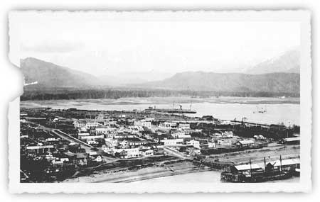
| Seward, as it appeared circa 1923. The railroad dock is at bottom right; the San Juan dock is in the center of the photograph. Neville Public Museum, photo 5671.10. |
After the founding of Seward, much of the coastal shipping for the next several years supported railroad construction activities. The Alaska Central laid tracks for approximately 70 miles north of Seward. Beyond the end of track, grading crews worked for several miles more and company surveyors canvassed the entire 350-mile route to Fairbanks. In order to expedite track-laying activities at the northern end of the Kenai Peninsula, many ships (as noted above) circled the western end of the Kenai Peninsula during the first decade of the twentieth century. These coastal shipping activities continued, first by private firms and then by the Alaska Engineering Commission, until the Alaska Railroad was completed. [15]
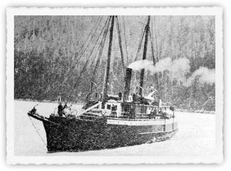
Long before the frenzy of railroad construction died down, shipping traffic based on other needs surfaced. As early as 1903, ships from Seattle regularly served Seward. Companies that served Seward during its first decade of existence included the Alaska Steamship Company ("Alaska Steam"), Northwestern Steamship Company and Alaska-Pacific Navigation Company. All three firms at one time or another owned the Dora, a workhorse craft that had first visited Resurrection Bay in 1896. The Dora remained in the area for many years thereafter, connecting Seward with points on Kodiak Island, the Alaska Peninsula, the Aleutian Islands, and Bristol Bay. [16]
|
| The steamer Dora sailed along the Kenai Peninsula's southern coast, and to "westward" points, during the late 19th and 20th centuries. The Pathfinder, May 1920, 3. |
In 1912, growth in what was then known as "southwestern Alaska" convinced the Alaska Steamship Company to begin serving Cook Inlet points. Two years later, the government's decision to construct a railroad bolstered traffic volumes. Then, in 1916, the Pacific Steamship Company ("the Admiral Line") began competing against Alaska Steam. The two companies brought both residents and tourists into the area; they continued to compete for traffic until the Admiral Line faded away in the spring of 1933. Both carriers featured Seward on their itineraries, and both sailed around the Kenai into Cook Inlet as well. The Admiral Line engaged in local service shipping in Cook Inlet throughout this period, typically serving Seldovia, "Ninilchick," and Anchorage. Alaska Steam, however, discontinued its regular Cook Inlet operations after the 1916 season, probably because the railroad had been completed from Seward to Anchorage that year. [17] No major carriers are known to have plied the waters of Cook Inlet after 1933.
|
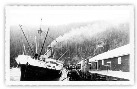
| Ships such as the Alaska Steamship Company steamer Alaska brought tourists from Seattle to Seward and other Alaska points during the 1920s and 1930s. Neville Pulic Museum, photo 5670.10. |
Local newspapers provide specifics about the Admiral Line and Alaska Steam ships that provided Seward-Seldovia service between the two world wars. In 1919, the Admiral Watson sailed between the two points, [18] but during the early 1920s both the Admiral Watson and the Admiral Evans ships plied the route. [19] By 1927, both the Watson and the Evans remained on the route, but only on an intermittent basis, and by 1929, only the Watson remained. [20] The only known Alaska Steam vessels serving the route during this period were the S.S. Redondo and the S.S. Curacao, which made occasional trips to supply area canneries. [21]
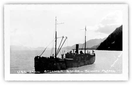
Those who lived and worked in Cook Inlet, however, demanded transportation to more than two or three ports. In order to service a broad spectrum of destinations (including destinations within the present-day park), several ships, most of which were based in Seward, carried passengers and freight. The S.S. Starr, owned by the San Juan Fishing and Packing Company (which operated a Seward cannery from 1917 to 1930), provided service to the Alaska Peninsula and the Aleutian Islands, with occasional stops in Cook Inlet and Kodiak Island, from 1921 to 1938. [22] In 1923, Seward-based guide Charles Emsweiler began serving Nuka Bay with the gasboat May; in 1925 he still served the area with the gasboat Chase. [23] In 1927, Capt. Heinie Berger commenced serving the area with the motor ship Discoverer. He provided service to Nuka Bay and Cook Inlet for the next two years. [24]
|
| The steamer Starr was another fixture along the southern Kenai coast, in Cook Inlet, and points west during the early twentieth century. Neville Public Museum, photo 5671.11. |
Berger discontinued service to Nuka Bay after the 1928 season, but by the following summer Capt. Pete Sather (known to locals as "Herring Pete") was offering twice-monthly service to the bay. During the early and mid-1930s he and his gas boat Rolfh operated as the Nuka Bay Transportation Company, and from the late 1920s through the 1940s he offered the only consistently-available passenger, freight, and mail service between Seward and Nuka Bay. [25] Berger, with the Discoverer and a sister ship, the Kasilof, continued to provide occasional service to Cook Inlet points until World War II, and several competitors also provided service during this time. When the war began, however, some of the Cook Inlet fleet was commandeered for war purposes. [26] After the war, the increasing popularity of aviation and the completion of highways connecting Anchorage with the various Kenai Peninsula communities diminished the demand for such services. In addition to these common-carrier vessels, commercial fishing boats–particularly those plying the waters between Prince William Sound and Kachemak Bay–sailed along the Kenai Peninsula's southern coast on a fairly consistent basis beginning in the 1920s, perhaps earlier. [27]
Two primary shipping lanes, both of which had been described by 1910 in the Alaska Coast Pilot Notes, followed the Kenai coastline for those who traveled between Seward and Cook Inlet ports. The larger craft–the Admiral Line ships, Alaska Steamship vessels, and others who did not need to make way stops–left Resurrection Bay and headed south past the Chiswell Islands. They then turned right; some passed between Lone Rock and the more distant Seal Rocks, while others continued beyond Seal Rocks before turning. They then paralleled the coastline, passing to the south of the Pye Islands and Nuka Island, and circled around the southwestern tip of the peninsula after passing between the Chugach and Barren Islands.
Smaller boats proceeding between Seward and Cook Inlet stayed closer to the coastline. These boats, after leaving Resurrection Bay, typically turned right immediately after passing Aialik Cape. They then used one of two passes to navigate through the Harbor Island-Chiswell Island group. Some mariners maneuvered through a passageway that lay just north of Beehive Island, while others used the pass that lay immediately south of Harbor Island. Boats then proceeded through fairly open sea to McArthur Pass (a narrow sea lane between Ragged Island, the northernmost of the Pye Islands, and the mainland). After crossing Nuka Bay, boats maneuvered through Nuka Passage and continued south to Gore Point. [28]
kefj/hrs/hrs5a.htm
Last Updated: 26-Oct-2002