|
Kenai Fjords
A Stern and Rock-Bound Coast: Historic Resource Study |

|
Chapter 1:
THE STERN AND ROCK-BOUND COAST
The whole coast between Cape Saint Elizabeth in the west and the mouth of Copper River in the east is deeply indented with coves and fiords, and towering peaks rise abruptly from the sea. Nearly every valley and ravine has its glacier, some of the latter being among the most extensive in the world. [1] — Ivan Petroff, 1880
Geographic Overview
|
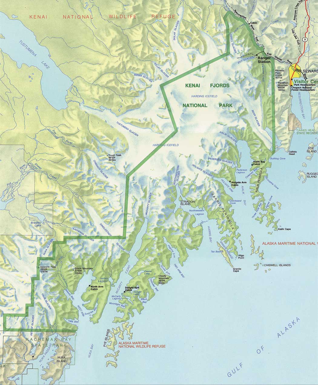
| Map 1-1. Kenai Fjords National Park. (click on imasge for an enlargement in a new window) |
Kenai Fjords National Park is a sequestered glacial landscape of ice, tidewater glaciers, deeply chiseled fjords, and jagged peninsulas formed by the forces of the Harding and Grewingk-Yalik icefields as they plunge into the sea. Located on the southeastern or seaward coast of the one hundred and seventy-mile-long Kenai Peninsula, the park abuts the Kenai Mountains to the north and west. These lofty mountains, part of the Chugach and St. Elias ranges, bisect the peninsula close to the southeastern coast and extend to Kodiak and Afognak islands. Only the mountain peaks (nunataks) are visible above the permanent mantle of ice and snow of the icefield. Along the coast, the summits of the same mountain range surface as offshore island stacks. As the glaciers recede the fjords deepen, enlarging and exposing peninsulas that indent the coast and disappear into the sea.
The setting is dynamic. The park is located on an active tectonic shelf of the Pacific Ocean Plate that follows the coast from Port Dick (west of Nuka Bay) to Day Harbor (east of Seward) in one of the most seismically erratic regions of the United States. During the 1964 earthquake lands within the Kenai Fjords National Park subsided. The tremor dropped the coastline from three to six vertical feet in most areas and attempted to counterbal-ance the force by raising it in others. As the shifting plate moves and grates against the continental landmass, the coast submits to the sea. This process is believed to have begun after the last major period of glaciation, 20,000 years ago.
|
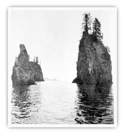
| Sea stacks are a common feature along the Kenai Fjords coastline. M. Woodbridge Williams/NPS photo in Alaska Regional Profiles, Southcentral Region, July 1974, 36. |
Glaciers and deep fjords in the southwestern portion of the Kenai Fjords radiate from the colossal snow pack of Harding Icefield. In 1950, the USGS officially named the icefield for President Warren G. Harding who died in 1923, soon after the first presidential visit to Alaska (see chapter 10). Ten of the thirty-four tidewater and hanging glaciers that emanate from Harding Icefield are included within the park. [2]
The mile-high Harding Icefield is a glacial vestige of the 10,000-year-old Pleistocene period when an expansive ice sheet blanketed southcentral Alaska. The icefield may also be a remnant of the massive Truuli Icefield, recorded by the naturalist Ilia G. Wosnesenski in 1842 that comprised both the Sargent and Harding icefields. Heavy winter snow loads feed the glaciers at higher altitudes as moist air settles above the mountains. Snowfall occurs primarily in the winter months though summer storms are not uncommon; the icefield accumulates as much as 400 inches of snow annually. Warming winds off the Gulf of Alaska temper winter weather creating a maritime climate. Glacial runoff feeds the streams and lakes that drain into the comparatively milder terrain and lowland component of the peninsula. Glacial till and moraines covered in vegetation constitute most of the low-lying lands. Landing beaches are few. Deep snow on the mountainsides increases the likelihood of avalanches in these lower areas. [3]
The park includes Bear and Exit glaciers in the vicinity of Seward. The parklands then proceed south and west on the Kenai Peninsula to Petrof Glacier west of Nuka Island. The park's northern boundary bisects the Harding Icefield. All coastal areas between Bear and Petrof glaciers are part of Kenai Fjords National Park.
Park boundaries exclude almost all offshore features: open sea, channel water in the fjords, pinnacle rocks, and islands. The signing of ANILCA in 1980, transferred most of the offshore islands to the Alaska Maritime National Wildlife Refuge. Significant island groups fall under this category; they include the Pye and Chiswell islands, which are major bird conservation habitats.
|
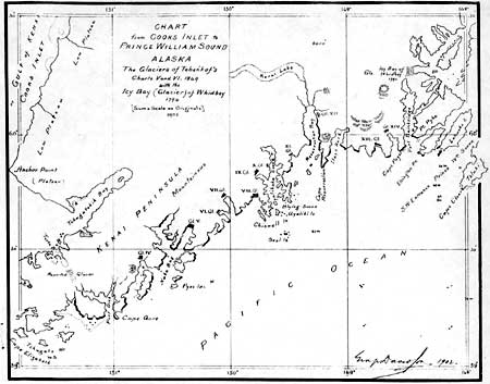
| George Davidson's illustration of glaciers on outer coast in 1902. Bancroft Library. |
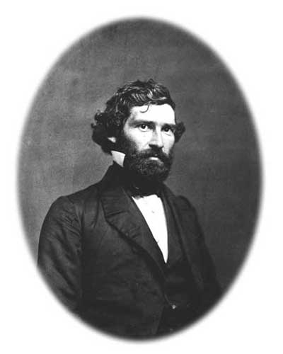
In 1867, English-born George Davidson, a geodesist with the U.S. Coast and Geodetic Survey (USC&GS), supervised what many consider the first American coastal assessment of Alaska under a directive from Congress. Relying heavily on the cartography of Teben'kov and his navigators, other Russian ship captains, and Vancouver, Davidson compiled a descriptive account of coastal positions and natural resources from Sitka to the Pribilof Islands which he submitted to Congress in the 1869 USC&GS annual report. In it, Davidson offered the following introductory description of the vicinity:
From Cape Puget to Cape Elizabeth the shores have been very well explored by the Russian navigators, searching for good harbors and shelter for the Russian whalers. Their reports show that the line of coast is broken by bays and coves, but none offering good anchorage; there being very close to shore not more than thirty to fifty fathoms of water. The coast is very rocky, steep and mountainous, yet covered with wood, while the ravines and gorges between the mountains contain in many places, glaciers which stretch back from the heads of the bays even to the gorges descending towards Cooks inlet. [4]
Many descriptions of the coast in later years followed Davidson's version; most of them presented an equally rugged portrait of the land and its glaciers.
|
| George Davidson portrait. Bancroft Library. |
kefj/hrs/hrs1.htm
Last Updated: 26-Oct-2002