|
Katmai
Building in an Ashen Land: Historic Resource Study |

|
CHAPTER 3:
RUSSIAN AND EARLY AMERICAN INFLUENCE (continued)
Historic Properties Summary and Recommendations
Along the Katmai Coast (from south to north):
Katmai Village (AHRS Site No. XMK-014). There have been two documented site visits to the Katmai village area.
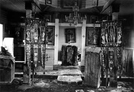
In 1915 the National Geographic Society expedition, led by Robert F. Griggs, visited the Katmai area, taking photographs of barabaras, the ROC chapel, graveyard with a wrought-iron fence, and at least two log or wood frame buildings, one of which might have been the trading store. Griggs also discovered signs of a flood that had swept through Katmai village and noted its affect on the buildings and structures. "The Orthodox chapel, through reasonably intact, had been swept off its foundations and bore a high water mark of 5-1/2 feet above the ground. Many barabaras were completely filled with water-borne ash, and the heavy roof of one had been floated away...." [141]
In 1953, archeologists from the University of Oregon visited the site. Wilbur A. Davis and his co-workers found excavating nearly impossible since ash and pumice covered the former village to a depth of 2-1/2 to 5 feet. In addition, the "debris-choked beds of nearby streams had raised the water table so that the former settlement was a series of grass-covered hummocks separated by pumice flats" under which the water rose to within a few inches of the surface. The crew did identify a graveyard with some crosses still standing as well as the chapel remains and the trading post, although the ash and pumice covered the building up to its eaves. [142] It is recommended that the site be visited to see if the ground is now stable enough to permit an archeological investigation.
|
| Interior of the Katmai chapel after the flood, 1915. Photo courtesy of University of Alaska Anchorage, Archives and Manuscripts Department, National Geographic Society Katmai Expedition Collection, Box 1, 3773. |
Dakavak Bay (AHRS Site No. XMK-049). This site "Archaeological Site 49 MK10" was listed on the National Register of Historic Places for its prehistoric significance. Archeological investigations also noted one post-contact dwelling at Dakavak Bay. In 1912, a family was known to have seasonally lived in a dwelling at Dakavak Bay. [143] Recommend further historical archeological investigation at the site.
Takli Island, Amalik Bay, and Cape Atushagvik vicinity: This region was probably used at least intermittently, throughout the Russian and American periods. In 1895, the Kodiak priest had left Katmai and was travelling north when he mentioned stopping at a barabara on the way to the narrowest point of land for taking off to Kodiak Island. Undoubtedly other structures are located in the area. Recommend further historical archeological investigation.
Kaflia (AHRS Site No. XMK-007) is located close to Kaflia Bay. Wendell Oswalt's 1954 archeological investigation at Kaflia revealed the remains of four historic semi-subterranean houses, including some with tunnel entrances. The suggested occupation dates are circa AD 1500-AD 1912. This site could be related to the seasonal fishing camp and fishery, that included a saltery and store, which was active prior to the 1912 eruption. There has been some vandalism at the site. Recommend further historical archeological investigation.
Kukak Village (AHRS Site No. XMK-006), located on the north shore of the bay, is listed on the National Register for its prehistoric significance. Archeological investigation that did not focus on the historic material, discovered some historic remains and artifacts including a collapsed structure made of boards, bricks, bottle glass and a gun barrel. No archaeological investigation has been done since the 1960s. Roy Fure, a trapper in the Katmai area during the early 1900s, stated that prior to the eruption, only trappers were living in the Kukak area. Recommend historical archeological investigation. Site is on ROC land.
At nearby Old Kukak (AHRS Site No. XMK-015), archeological site visits noted several mounds that could be the remains of dirt-floored cabins that were standing at the time of the 1912 eruption.
Northwest of Kukak (AHRS Site No. XMK-046). Archaeological testing in 1964 identified six house size depressions and determined that the site was occupied during post-contact times and probably for a short duration. Recommend historical archeological investigation for all three Kukak sites.
Hallo Bay. Roy Fure saw about nine houses in this area in 1914. This was the terminus of a route across the peninsula to Savonoski and Naknek. Recommend historical archeological investigation. [144]
Douglas (Kaguyak) (AHRS Site No. AFG-043). Listed on the National Register of Historic Places for both prehistoric and historic significance. Archeological investigations identified the remains of several historic properties including the Russian Orthodox Church chapel, a cemetery, thirteen historic houses, tent frames, outbuildings, a kazhim, and possible cabin foundations. A 1964 site visit noted that the church had been vandalized and burned. Recommend working with the ROC owner to reinvestigation the area with an historical archeological focus. Some vandalism has already occurred at the site. Recently, the ROC has been leasing this land to a tourism operator. The ROC should be encouraged to work with NPS and other appropriate groups, namely the Katmai descendents, to protect this site that includes a cemetery.
Swikshak (AHRS Site No. AFG-044), near Swikshak Lagoon. A 1989 site visit by archeologist noted a historic midden. Recommend further historical archeological investigation.
Cape Douglas: There is potential for finding historic sites related to sea mammal hunting camps located along Kamishak Bay to the south of Cape Douglas. There may also be a trading post located around the Cape Douglas headland. Recent archeological investigations around the Cape Douglas headland documented the following sites:
(AHRS Site No. AFG-202) on the southwest side of the cape. The 1994 NPS SAIP [145] archeological investigation noted an historic settlement consisting of three house depressions. One house is rectangular (4 m x 3m) with horizontal milled floorboards and vertical posts.
(AHRS Site No. AFG-108) on the north shore of Cape Douglas. A 1989 archeological investigation noted two rectangular, historic cabins outlined with sod berm. Foundations are 3m x 4m with clear entryways.
(AHRS Site No. AFG-107) on the east end of Cape Douglas. 1989 archeological investigation noted a possible structural depression.
(AHRS Site No. AFG-171) on the southeast end of the cape. A 1990 archaeological investigation documented two houses. One house has a large chamber with multiple siderooms that indicate similarities with late prehistoric and early historic periods on Kodiak Island. The second house is considered to be post-contact with its associated vertical posts that were cut with a metal saw. It is also considered to have been a ruin prior to the 1912 eruption. Located nearby were historic debris that includes stove parts, a pickaxe head, iron spikes, cut nails and iron fragments. All iron is heavily rusted. The site may be associated with a Sugpiat/Alutiiq occupation and perhaps sea mammal hunters.
Ashivak (AHRS Site No. AFG-037). This is not the location identified on modern maps, but is closer to Cape Douglas along the coast. This is considered an historic site with chipped knife blade and scraper. Recommend further historical archeological investigation.
Naknek River Drainage:

|
| The waterfront at Old Savonoski showing the main line of barabaras. 1918 photo courtesy of University of Alaska Anchorage, Archives and Manuscripts Department, National Geographic Society Katmai Expedition Collection, Box 4, 3675. |
Savonoski (AHRS Site No. XMK-001). This former settlement is listed on the National Register of Historic Places for its prehistoric and historic significance. Photographs from the National Geographic Society's expedition of 1916 showed several barabaras lined up along the river with elevated wooden caches behind the houses, one house made out of peat moss blocks, and the log Russian Orthodox chapel. A 1953 archeological investigation of Savonoski revealed many historic properties including fifteen semi-subterranean houses, filled in by sand and pumice, with split cottonwood log frames and rectangular shapes. The high water table level prevented excavation of the kazhim. Little remains of the site today.
Savonoski River Archaeological District (AHRS Site No. XMK-053) includes two sites. This district is listed on the National Register of Historic Places for prehistoric and historic significance. Evidence of the historic period was found during the 1964 archeological investigation at Kanigmiut (AHRS Site No. XMK-003) which revealed about nine house depressions.
Grosvenor Site (AHRS Site No. XMK-004). Roy Fure reportedly visited this site in 1914 and saw three barabaras on the stretch of land between Grosvenor and Coville lakes. Archeological investigations in 1963 noted several surface depressions in the area.
Brooks River Archaeological District (AHRS Site No. XMK-051). This is a National Historic Landmark site that includes caribou hunting and fishing camps with more or less continuous occupation until about AD 1820. The site include an AD 1900 historic house depression (AHRS Site No. XMK-037).
Alagnak River Drainage:
Alagnak River Russian Orthodox Chapel (AHRS Site No. DIL-036). A 1997 archeological investigation identified and documented the remains of a log ROC chapel. The chapel consisted of a vestibule and nave with a bay. There is a stack of three ROC grave markers at the site. Recommend ethnographic study, and research of Alaska Russian Orthodox Church records as related to the Nushagak Mission to reveal the history and use of this chapel.
katm/hrs/hrs3b.htm
Last Updated: 22-Oct-2002