|
KATMAI / ANIAKCHAK
Isolated Paradise: An Administrative History of the Katmai and Aniakchak National Park Units |

|
| PART I: KATMAI NATIONAL PARK AND PRESERVE |
Chapter 10:
Cultural Resource Management
Today, the Katmai area is of tremendous interest to cultural resource professionals. Located at the northern end of the Alaska Peninsula, it is a zone of cultural transition and complexity, a place where humans have lived and intermingled for thousands of years. Both the history and archeology of the area are remarkable. As a reflection of its importance, nine Katmai properties are listed in the National Register of Historic Places. But when the monument was proclaimed in 1918, few cared about investigating or protecting the region's historical resources, and few were aware of its archeological resources. Most of what is known has been gathered only since the 1950s. Early investigations were usually funded through universities; more recently, agency personnel have performed most of the work.
Early Cultural Resource Concerns
Before 1950, as has been noted, the National Park Service had no on-site personnel stationed in Katmai. The agency's major concerns during the early years of the monument were the protection of wildlife populations and the removal of illegal residents. It therefore had only a tangential interest in the area's cultural resources.
The agency's first interest in the area's cultural complexity was a legal one. NPS personnel were concerned, at an early date, whether area Natives had justifiable claims to land within the monument. During the 1930s, Interior department officials had become aware that Natives from New Savonoski had been visiting the Savonoski River valley every summer since 1918, both to hunt and to tend the graves of their ancestors at Old Savonoski. The Natives, having been told that hunting was prohibited, probably ceased their hunts in the area after 1939, but they continued to visit Old Savonoski for years afterwards. [1] (They never tried to resettle the old village because the layers of pumice, and the resulting soil acidity, made residence impossible.) In early 1941, Cadastral Engineer George Parks told Mount McKinley's superintendent, Frank Been, that no Natives had filed for allotments in the monument, nor would such allotments likely be filed in the future. [2]
Been should have known better. By that time, he had already learned firsthand that local Natives not only visited the monument from time to time but that they also occupied several cabins on a seasonal basis. The previous summer, he had visited the mouth of "Brooks Creek," where he found a "fishing village" which consisted of two cabins--both on the south side of the river--and a series of tents. At the time of his first visit the site was populated by a woman and two boys. He returned a week later and found the chief of New Savonoski with his wife and three younger men, one of whom mentioned that about forty people would soon be gathered there to harvest the fall salmon run. [3]
Natives continued to use Brooks Camp for their fall fish harvest for decades to come. In 1950, the opening of the concessions camp exposed them to an increasing degree of scrutiny and competition from sport fishermen. The Native population, as a result, began to feel out of place. They reacted by postponing their fish-harvesting activities until after the camp had closed. After 1960 their use of the area declined, but it did not cease altogether. It should hardly have been surprising, therefore, that an elderly Native woman, in the spring of 1971, filed a claim for land at the mouth of Brooks River. [4] (See Chapter 6.) About 1950, the Bureau of Land Management gave notice that all land claimants, Natives, settlers, or squatters had up to two years to file claims for land not previously recorded. No applicants came forward at this time to claim land in the monument. This notice, however, was evidently overturned at some later date in order to allow the Brooks River and other Native claims to be filed. [5]
NPS also expressed an interest in Katmai's cultural resources by gathering information on culturally significant sites. Archeologists began searching for sites on the northern part of the Alaska Peninsula in the 1920s. Before 1950, however, the only known site recorded in the monument was one which Robert Heizer located on Takli Island in 1935. Heizer, at the time, was working in conjunction with Ales Hrdlicka, an archeologist affiliated with the Smithsonian Institution, whose primary work was at Uyak Bay on Kodiak Island. [6]
Although little of significance had been recorded in the monument before 1950, NPS officials knew of several archeological sites that had not yet been investigated. They were aware, for example, of Katmai village and Old Savonoski, both of which had been abandoned in the 1912 eruption. During his 1940 visit, Superintendent Frank Been learned of another abandoned village at the junction of the Grosvenor and Savonoski rivers. Been visited one of the three old villages, Old Savonoski, that summer and became so intrigued by the place that he proposed that it be reconstructed and displayed for interpretive purposes. That proposal, however, was rejected by his superiors in the regional office. [7]
Been also learned, from personnel at the Bureau of Commercial Fisheries facility at Brooks Lake, that the area along Brooks River was rich in cultural resources. On the south side of the river, he saw "the site of Indian houses which were now only depressions in the ground," a grave with a Russian cross, and other sites indicating that Natives had been occupying the area for generations. Early NPS personnel who served in the area made similar observations. [8]
The Katmai Project
In 1950, the NPS established its toehold at Brooks Camp and Northern Consolidated opened its various fishing camps. The deployment of personnel to the monument showed that the National Park Service was unwilling to ignore the area. Little interest was shown in Katmai's cultural history, however, until 1952, when the National Park Service organized the Katmai Project, a multidisciplinary research project largely funded by the Office of Naval Research (ONR). Three major investigations took place as a result of that project. [9]
In 1953, the NPS arranged for two University of Oregon graduate students, Wilbur A. Davis and James W. Leach, to survey three Native villages--Old Savonoski, Kukak Bay, and Katmai--which had been abandoned since the 1912 volcanic eruption. Davis and Leach visited all three sites, but were unable to locate anything at Katmai village because of the depth of the ash flow. They therefore investigated Kaguyak (Douglas village) as an alternate site. At the close of the season, the crew visited the Brooks River fishing camp. Upon their arrival, they were told that NCA personnel had recently discovered several artifacts while digging a root cellar. [10] Perhaps based on that news, the students recorded four extensive sites--two north of Brooks River, the other two south--and excavated a trench in the site closest to the fishing camp. The Brooks River sites were destined to be the first of many found in the area. Before long, in fact, archeologists recognized that the various terraces which wound through the area between Brooks Lake and Naknek Lake comprised a huge, world-class archeological complex. [11]
Though initial plans had called for the Katmai Project to expire after the first year, ONR was able to fund a second year of projects. Heeding the call to assign work to local academic institutions, the NPS invited University of Alaska anthropologist Wendell Oswalt to carry on survey work in Katmai that summer. As a result, Oswalt conducted a survey along the Shelikof coastline, where he located sites near Cape Douglas and at Devils Cove. He then excavated a small site at Kaflia Bay. [12]
The third activity that took place as a result of the Katmai Project was the preparation of a historic resource study. In the spring of 1953 Herbert Kahler, the agency's chief historian, told regional officials of the need to compile a Katmai bibliography. [13] But George Collins, the Alaska Recreation Survey chief, encouraged John A. Hussey to prepare a full historical narrative. That summer Hussey amassed a huge amount of data, chiefly from files available in the San Francisco area. Hussey had originally hoped to write a detailed account of conditions at Katmai from prehistoric times to the present day, but the press of other work necessitated that the detailed portion of his history be truncated in 1918, the year Katmai was designated a national monument. [14]
During the next few years, NPS officials got wind of other cultural resources that had never been scrutinized by professionals. Grosvenor Camp, for example, was found to be a culturally important site, just as Brooks Camp had been. Roy Fure, the trapper who had lived in the Bay of Islands area for years, noted that an "old Indian" had once lived at the site for about five years and had built a sod hut and sweat house. [15] Near Kulik Camp, an NCA employee had discovered a site in the early 1950s, and in the early 1960s another concessions employee had found a site near the outlet to Kukaklek Lake. These sites, both of which were outside the existing monument boundaries, were finally visited by archeologists in 1963 and 1965, respectively. [16]
In 1959, interest was kindled in conducting a comprehensive archeological survey of the monument. Ivar Skarland, the head of the University of Alaska's Anthropology Department, suggested the idea to officials in the Western Regional Office. The project would require a crew of six for the next three to five summers. The university would supply the requisite labor, while the NPS would provide funding. The project, however, never got beyond the planning stages; the NPS submitted a budget for the project, but funding was not approved. [17]
University of Oregon Investigations
In 1960, archeological efforts were resurrected at the park through the efforts of the Bureau of Commercial Fisheries, an agency which at that time was part of the U.S. Fish and Wildlife Service. The BCF hoped to gain some long-term indication of the aboriginal salmon catch somewhere in Alaska. The agency chose Brooks Camp as its research site for two reasons: a BCF research station was located in the area, and previous research had shown that a longitudinally extensive deposit was located in the area. [18] George Harry, the BCF agent who organized the project, had recently moved to Alaska from Oregon; because he knew of the expertise of anthropologists at the University of Oregon, he contacted department head Luther S. Cressman, who agreed to serve as principal investigator for a Brooks Camp-based project. Cressman, in turn, applied to the National Science Foundation (NSF) for additional support funds. The BCF and NSF shared funding obligations that year; the latter organization, however, promised funds for an additional year. The NSF, as it turned out, provided a total of five years' support for Brooks Camp research; it funded the University of Oregon in 1960 and 1961, and again in 1963 through 1965. [19]
Dr. Cressman enlisted Don Dumond, then a graduate student, to be the field supervisor for the 1960-61 Brooks Camp excavations. Dumond, working with one assistant, located three additional sites in 1960, all on the south side of Brooks River, and excavated one of them. The following year, Dumond and two assistants located two new sites on the river's north bank and excavated one of the sites which had been located in 1960. Altogether, archeologists had located nine sites in the Brooks Camp area and had excavated three of them. [20]
The University actually had two crews in the area in the summer of 1961. The second crew, led by Wilbur A. Davis, worked along the lower Naknek River and located four sites. All were located outside of the monument, although the data that the sites contained helped explain the cultural evolution that took place at Brooks Camp, Savonoski, and other sites inside of Katmai's boundaries. Davis's greatest contribution to the monument's cultural history, however, may have been the series of interviews he conducted with elderly local residents. Several people who had witnessed the 1912 eruption were still alive, and Davis was able to obtain reminiscences from three of them: Mike McCarlo, Pelagia Melgenak, and Harry Kaiakokonok. [21]
Excited by the extensive deposits and the cultural complexity found within them, the University of Oregon applied to the NSF for two more years of field work. The grant, which was approved, designated Cressman (by now an emeritus professor) and Dumond (by now a Ph.D.) as joint Principal Investigators. Dumond, as before, continued to serve as field director. The University of Oregon archeologists anticipated that field work would be limited to Brooks Camp, but the NPS took advantage of their expertise and contributed additional financing which allowed two more years of archeological surveys in the monument.
Dumond, overseeing a crew of five, spent the summer of 1963 at Brooks Camp surveying and testing the area's archeological resources. His crew identified thirteen new sites, most of which were south of Brooks River; in addition, he located over 1000 large depressions and estimated that over half of them would reveal evidence of aboriginal occupation. Two other archeologists, Harvey Rice and Michael Nowak, were assigned to surveys elsewhere in the park. The two recorded the sites at Grosvenor and Kulik camps, located a new site at Cape Chiniak, visited previously-known sites at Grosvenor Camp and along the Savonoski River, and surveyed Kukak Bay as the site for a future excavation. [22]
In 1964, Dumond and an assistant continued their Brooks Camp work. A crew of five was stationed at Kukak Bay for an excavation. An additional two archeologists made a reconnaissance of the Katmai coastline, locating sites near Dakavak Bay, on Missak Bay and Swikshak Lagoon, and excavated a major new site on Takli Island. The summer's work was so productive that the results brought forth more questions than answers, and Dumond requested an additional season of research support. In 1965, crews made further investigations at Takli Island and found new sites at Amalik Bay. The work that year provided data that "seemed as complete as it was reasonable to expect," and the University of Oregon, for the time being at least, concluded its NSF-sponsored archeological work in the monument. [23]
University personnel, however, were destined to make many more visits to Katmai in the pursuit of archeological data. In 1966 Paul Schumacher, Regional Archeologist at the NPS's Western Regional Office, learned that the National Geographic Society might be interested in funding a research project in the area. [24] Schumacher, therefore, asked Dumond to suggest several avenues of research. The NGS, as a result, funded the excavation and consolidation of one or more aboriginal houses at Brooks River. Several barabaras had been excavated in previous years; the NGS, however, hoped to unearth one of the largest or best-preserved examples, re-create its traditional appearance, and display it to tourists. Dumond worked with a crew of three during the summer of 1967, and excavated three houses in his search for an adequate display site. He had initially felt that he might need to recreate a composite of houses, but one of the three, upon further investigation, proved optimal for interpretive purposes. Dumond, working alone, returned the following year and finished the reconstruction of the display house. [25]
The work which the archeologists completed during the 1960s was not accomplished in a vacuum. Although the archeologists took pains not to interfere with regular monument activities and operations, some effects were bound to take place. Many of the excavations, for instance, took place in relatively close proximity to Brooks Lodge and the other camp buildings. As a result, so many visitors took note of the crew's activities over the next several years--in part because of several open trenches in the camp area--that Brooks Camp's seasonal rangers were asked to provide informal interpretive services. [26] The "digs" taking place on both sides of the river were sufficiently interesting that they were advertised as one of Brooks Camp's major attractions during the mid-to-late 1960s. [27] Archeologists also discovered, much to their chagrin, that Brooks Lodge (constructed in 1960-61) was located on a site rich in artifacts. They were in no position, however, to interfere with the construction work. [28]
Archeological Work During the 1970s
Dumond and his associates at the University of Oregon felt, as a result of their investigations during the 1960s, that they had sufficient data to provide a broad model of cultural development on the northern Alaska Peninsula. He had, during that time, investigated sites at Brooks Camp, along Shelikof Strait, and on Bristol Bay. He had hoped that data found at sites at Bristol Bay would be able to help explain Brooks Camp's cultural development. But as he completed his monograph on the subject, he came to the realization that the Brooks River cultural sequence could not adequately be explained by data gathered at existing Bristol Bay sites. [29]
He responded to the paucity of data by applying to the National Science Foundation for a two-year grant (later extended for a third year) to investigate sites along Naknek River and the upper Ugashik River drainage. Most of that data, while helpful in explaining the Brooks River cultural sequence, did not take place within the present boundaries of the park. Seven sites were located along Naknek River in 1973, none of which were located in the park. Of the Naknek area sites discovered in 1974, only one--located just below the outlet of Naknek Lake--was situated inside of the present park. In 1975, most of the archeological exploration took place in the Ugashik River drainage, but based upon information provided by a local hunter, a new site was recorded along the western park boundary. The site location, more specifically, was in upper Big Creek, west of Brooks Lake. [30]
In 1973, another archeological survey took place along Shelikof Strait. In conjunction with a shorebird survey, Allen McCartney examined the coastline from the railing of a U.S. Fish and Wildlife Service ship. McCartney's search was largely unsuccessful. He found only one previously unrecorded site in the monument, at Missak Bay. [31]
Archeological work was also conducted at Brooks Camp during the same period. The NPS, via contract, had a utility system installed in the summers of 1974 and 1975. The contract called for the underground installation of fuel tanks, water lines and sewer lines across much of Brooks Camp. In order to mitigate some of the impacts of the construction activity, the agency dispatched Harvey Shields, a University of Oregon graduate student, to Brooks Camp during the late summer of 1974. His major project was the excavation of an ena (semi-subterranean house), but he also unearthed a number of artifacts and three burial sites which lay in the path of construction. [32]
Try as he may, Shields found it impossible to keep up with the pace of construction. He found the construction workers uncooperative--their schedule apparently did not provide for on-the-spot archeological mitigation--and as a result "at least eight aboriginal houses and at least two burials were seriously disrupted." Dr. Dumond, who served as project supervisor, lambasted regional NPS officials for ignoring the monument's cultural heritage. He urged that only archeologists be allowed to excavate; at the very least, he demanded that all excavations be done in the presence of an archeologist. But the damage had already been done. The acting regional director responded, somewhat sheepishly, that the agency was still in the process of creating a construction proposal monitoring system; he hoped that the newly-established system would prevent a recurrence of the Brooks Camp difficulties. [33]
Inventory and Nomination Activities
In 1975, the NPS launched an effort to place some of the monument's most significant sites on the National Register of Historic Places, the government's list of valuable cultural properties. That October, the Regional Archeologist in the Pacific Northwest Regional Office, Fred Bohannan, wrote an Archeological Resources Assessment for the monument. The assessment was a tardy response to Executive Order 11593, proclaimed by President Richard Nixon in May 1971, which required all federal agencies to "locate, inventory, and nominate to the Secretary of the Interior all sites, buildings, districts, and objects under their jurisdiction or control that appear to qualify for listing on the National Register of Historic Places" by July 1, 1973. [34]
Bohannan's assessment consisted of an inventory and evaluation of the monument's sites. Of the 29 sites which had thus far been inventoried, he considered 19 of them, alone or in tandem with others, to be eligible to the National Register. The sites comprised eight nominations: Brooks River, Kaguyak, Kukak, Old Savonoski, Savonoski River, Takli Island, and sites located near Cape Chiniak and Dakavak Bay. (The Savonoski River nomination was composed of two archeological sites, while the Takli Island nomination was composed of twelve sites.) The remaining sites in the monument were not nominated. [35] Bohannan's recommendations were accepted by the National Register officials, and all eight nominations were entered onto the register between February and July 1978. [36]
The same year in which Pacific Northwest Regional officials began inventorying known archeological sites, Denver Service Center personnel commenced an inventory of structures in the monument. Robert Carper, from DSC's Historic Preservation Division, visited Katmai in August 1975. The following spring, he completed a report showing the results of that inventory and nominating eligible structures to the List of Classified Structures, which was the agency's catalog of structures having archeological, historical, architectural, or engineering significance. Carper's inventory noted that the monument included a total of 102 structures; 32 were owned by the NPS, 33 by other governmental agencies, 35 by the concessioner, and one by a company working on an NPS contract. Few of those structures, however, were particularly noteworthy. Only 78 of those structures were enclosed buildings, and only three were recommended for the List of Classified Structures. Those three were the reconstructed ena ("Eskimo Pit House") near Brooks Camp; "Important Packer Scotty's" (Stephen M. Scott's) Cabin, also near Brooks Camp; and Fure's Cabin, in the Bay of Islands area of Naknek Lake. Carper was most enthusiastic about Fure's Cabin, which he noted as "The most significant and extant post-eruption structure." [37] In conjunction with that report, Superintendent Gil Blinn nominated the cabin to the National Register of Historic Places in January 1976. The state's Historic Sites Advisory Committee judged that it fulfilled the criteria for inclusion to the register. The NPS, however, did not forward the nomination to the National Register office in Washington, D.C. [38]
Soon after the release of Carper's report, more information was gathered on the park's historic structures. Ranger Mike Tollefson compiled a history of the old trappers' cabins, and park personnel during the next several years found opportunities to visit most of them. All available information confirmed that Roy Fure's original cabin, in the Bay of Islands, was the most structurally sound historical structure in the park. It was relatively accessible to visitors, and was of considerable historic significance as well. [39]
Park staff did what they could to preserve the old cabin. Broken windows and rotting floorboards were replaced, and the interior was placed off-limits to visitors. By 1982, however, rising budgets gave Katmai officials the opportunity to consider a more extensive rehabilitation. Officials visited the site that summer and decided to rehabilitate it. [40] The following summer they returned and made further structural examinations. They also collected some nine nautical charts and 90 other historic objects from the site. The two collections were removed to King Salmon and became the basis for the park museum. [41] Based on those visits, they prepared a historic structure report for the cabin and the various outbuildings which surrounded it. [42]
The rehabilitation project, however, was delayed until 1987. In a process that was akin to the recently-completed Moore Cabin project in Skagway, two NPS cabin builders dismantled Fure's Cabin and separated salvageable logs from those which were no longer useful. Many of the sill logs, floor boards, roof planks and roofing needed to be replaced; other portions of the cabin were still in good condition. Reassembly began late that summer; the following year rehabilitation was completed, the salvageable logs being interwoven with fresh-cut replacements brought in from King Salmon. Additional historical materials were collected from the cabin area and transferred to the park museum. The builders that year had hoped to reconstruct the adjacent windmill and several minor outbuildings. That work, however, did not begin until 1993. Most of the necessary work was done that year; the remainder was completed in 1994. [43]
Actions toward recognizing the historical importance of the cabin went hand in hand with its physical rehabilitation. Based on the 1982 site visit, together with additional data which had been gathered by Gil Blinn in the mid-1970s, NPS historian Joaqlin Estus prepared a new National Register of Historic Places nomination form on the site. Shortly afterwards, Estus used much of the same information for the historical data section of the 1984 historic structure report. [44] The acquisition of new evidence caused the National Register nomination form to be revised in December 1983 and again the following August. Finally, on February 7, 1985, Fure's Cabin was entered onto the National Register. [45] During the reconstruction process, historian Bonnie Houston gathered a substantial amount of additional data on Roy Fure, his cabin, and his career as a trapper. Supplemental documentation was submitted in November 1988 and was accepted by the Keeper of the National Register on May 19, 1989. [46]
Recent Archeological Investigations
Since the mid-1970s, most of the park's archeological activity in areas west of the Aleutian Range has taken place in the Brooks Camp area. Unlike earlier efforts, most has been conducted by NPS archeologists. Large excavations have been a relative rarity; more common have been small-scale compliance activities. No broad survey efforts have been undertaken in recent years.
The largest single project in recent years was brought on by the floods which washed through Brooks Camp in the late 1970s. As Chapter 5 noted, high waters in 1977, 1978, and 1980 played havoc on the camp's docks. They also endangered several of the area's cultural sites, located as they were on both banks of Brooks River. Two sites, located on the south bank below Brooks Falls, were of particular concern.
To monitor the flood's impact on the site, Superintendent Gil Blinn ask Don Dumond to return to Brooks Camp in 1977 and assess the threat posed by river erosion. His recommendations, together with similar conclusions offered by NPS Area Office archeologist Dick Hsu, resulted in two years of site testing. [47] In 1979 Harvey Shields, now an Area Office archeologist, tested the site; in 1981, Shields returned and performed similar work at the site immediately downstream from the location of his earlier testing. [48]
In 1982 and 1983, archeologists carried on a full-scale excavation at the two sites which had been tested in 1979 and 1981. Harvey Shields, who had been participating at Katmai off and on since 1974, designed the project and served as Principal Investigator, while Roger Harritt, a University of Oregon graduate student, served as crew foreman. Others who served as crew members included Cindy Amdur Clark, Fred Clark, Dale Vinson, and Anne Worthington. Don Dumond, who served as technical advisor, visited for short periods during each of the two summers of the project. In 1984, Dumond himself headed a crew of three who, in a two-week period, completed the excavation of a burned semi-subterranean house. [49]
Three other recent projects have been completed, all by government archeologists. In 1983, as part of a larger Bureau of Indian Affairs survey, Neil Crozier located a historic burial complex on the park's western boundary. In 1989, archeologists with the NPS Mining Compliance Program surveyed an area north of Battle Lake. They recorded three sites: two lithic scatters and a probable hunting blind. Finally, Patricia McClenahan made an resurvey of the sites which comprised the Brooks River area National Register site. Her 1988 efforts resulted in the submittal, on March 24, 1989, of a National Historic Landmark (NHL) nomination for the area. On February 3, 1993, the NHL nomination was approved by the National Park System Advisory Board, and on April 19, Secretary of the Interior Bruce Babbitt officially designated the district as an NHL. [50]
Most of the remaining park archeological effort has been compliance work completed in conjunction with development projects. Section 106 of the 1966 National Historic Preservation Act requires that federal agencies weigh the broadly-defined historic importance of any site under their jurisdiction against any development actions that may be undertaken on those sites. Section 106, therefore, applies not only to Brooks Camp and other National Register sites, but it also applied to any park site with potential National Register eligibility. Given those requirements, NPS archeologists have been engaged in compliance activities in Katmai since 1974.
Relatively few compliance activities took place in the 1970s and early 1980s. The number of compliance actions, however, grew to four in 1982 and was at least ten for each year between 1987 and 1989. In 1991, an archeologist was added to Katmai's staff, and perhaps as a consequence, an increasing number of compliance actions took place. Eleven were recorded in 1991 and another 31 in 1992. Altogether, 97 Katmai compliance reports were prepared through 1992, 66 of which dealt with development activities in the Brooks Camp area. Of the remaining 31 compliance actions, 9 occurred along the Valley Road corridor, 5 in the King Salmon headquarters complex, 4 at various places along the Shelikof Strait coast, 2 at Lake Camp, 2 at Fure's Cabin, 2 in the Nonvianuk Camp area, 2 at Grosvenor Camp, and 5 at scattered sites along Katmai's lake shores. [51]
Most compliance projects have been relatively minor, consisting of one or two archeologists spending just a few hours at a site. But several have been more extensive, and in a few instances major finds have been located. In 1988, for instance, archeologists on a project related to Brooks Camp leach field development uncovered a heretofore unknown ena (pit house), the only known intact example of a clay seal-oil lamp, and indications of previously unsuspected cultural sites. That same year, two Takli Island visitors encountered a prehistoric skeleton, and compliance personnel investigated the surrounding area. In 1991, an archeologist investigating a fuel-line spill unearthed evidence of another ena; a year later, compliance actions related to a new well resulted in the discovery of a caribou tooth and other material from what may be the Beach Ridge cultural period (3800-4100 years ago), of which little is presently known. [52]
Once the NSF-sponsored surveys and excavations of the 1960s were completed, little archeological work was completed along Katmai's eastern littoral for the next 25 years. In March 1989, however, the Exxon Valdez oil spill brought renewed attention to the area. At first, NPS officials were confident that the oil could be contained within Prince William Sound, but by April 6 they felt otherwise. They hurriedly organized three field teams which assessed the coast's natural and cultural resources. Included in those teams were archeologists Pat McClenahan, Richard Jordan, and Rick Knecht; McClenahan worked for the NPS, while the others were on contract. Much of their survey work was restricted to the area below the high tide line. As part of that survey, they found a number of previously-unrecorded sites. [53]
Cleanup crews, sponsored by Exxon Company U.S.A., were deployed to Katmai's beaches in 1989, 1990, and 1991. Damage assessments were also conducted in conjunction with the cleanup. In 1989 and 1990 Exxon archeologists conducted aerial, pedestrian, and ship-based surveys, tested selected sites, and monitored cleanup operations. Only rarely did artifact collection take place. In 1989, company archeologists investigated 37 sites; a year later, they investigated another 14. In 1991, student archeologists from SUNY Binghamton conducted oil spill impact research on Katmai's shores. As part of their work, they located several previously-undiscovered archeological sites. [54]
Development of Museum Collection
As detailed in chapters 2, 11 and 12 as well as in the present chapter, scientific expeditions have been venturing into the Katmai country for more than 75 years. Some of those research efforts have been conducted by NPS investigators, others by those who had little or no connection with the agency. Many resulted in the collection of archeological, biological, or geological specimens. Prior to the 1980s, however, none of those collections were retained in the local area.
In 1983, Kathy Jope, Katmai's resource management specialist, moved to establish a park museum. As a result of the investigations which had taken place at Fure's Cabin, nine historic maps and 90 other objects had been removed. They, together with 165 copies of photographs from the early National Geographic Society investigations, formed the core of the new collection. Some of the items were stored, for the time being, at the Brooks Camp visitor center, while others were removed to King Salmon's ranger annex. [55]
In 1984, most of the park collection was consolidated in King Salmon. But the cramped, two-room ranger annex had little room for artifact storage; besides, it was poorly heated and ventilated, and thus inadequate for proper museum curation. To upgrade the facility, maintenance workers installed new insulation, a new ceiling, and shelving. Two years later, a reorganization at the park took place, and half of the building was given over to the park's library and museum. [56]
New artifacts were continuously added to the park's museum collection. By 1985, the park received its first archeological, archival, biological, paleontological, and geological specimens, and the collection numbered more than 400 total artifacts. That number swelled to 2600 the following year and to almost 5000 in 1987. Large archeological accessions swelled the museum's collection even further; by 1988, the collection numbered more than 82,000 items. [57]
By the end of 1992, Katmai's museum inventory included 128,807 items. Over 95 percent of them--125,468 items--were archeological in nature. The herbarium contained 1446 biological specimens. In addition, the park collection had 789 historical artifacts, 512 archival items, 420 geological specimens, 153 paleontological specimens, and 19 ethnological artifacts. [58]
Other NPS offices contain additional Katmai materials. Biological and archeological items are located in the Alaska System Support Office, and the agency's Harpers Ferry Center keeps additional archeological items.
Most of the items collected during earlier expeditions remain outside of NPS control. Archeological collections pertaining to Katmai are located at the University of Oregon, University of Alaska Fairbanks, Peabody Museum, and SUNY Binghamton, while the Bristol Bay Historical Society keeps a historical item. Geological collections with Katmai specimens are located at the University of Alaska Fairbanks and the U.S. Geological Survey, while biological collections are located at Ohio State University and the University of Alaska Anchorage. Other institutional and private collections, as yet unknown, are likely to also contain Katmai artifacts. NPS staff are carrying on a continuing effort to locate those artifacts and provide for their preservation. [59]
|
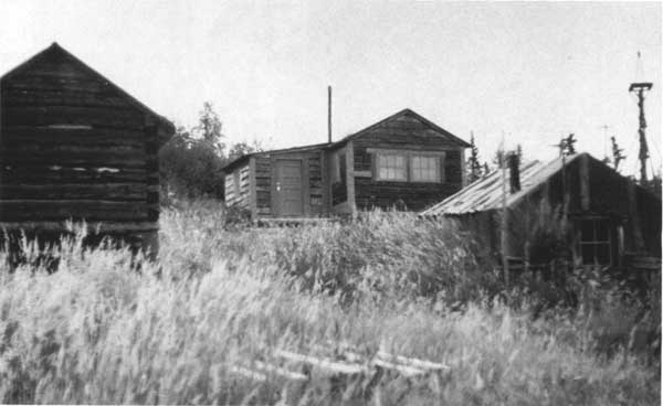
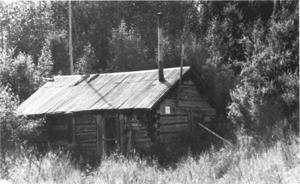
| (top) In September 1953, Victor Cahalane visited American Creek and photographed traper Roy Fure's storehouse (left), cabin (center), and cache. Fure used the buildings during the 1930s and, perhaps surreptitiously, thereafter. (bottom) Another of Fure's cabins was located in the Bay of Islands portion of Naknek Lake. Architect Robert Carper took this photo in April 1976. Agency personnel restored the cabin in 1987-1988; the adjacent windmill and outbuildings were restored in 1993-1994. (NPS Photo Collection, neg. 66-188 (top); Carper, Classified Structure, Field Inventory Report, Katmai National Monument, 10 (bottom) ) |
|
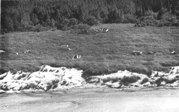
| Savonoski Village, along the south bank of the Savonoski River, was a viable Native village the June 1912 volcanic explosion forced its residents to flee. This photo, taken from the air by Victor Cahalane in July 1953, shows that "Old Savonoski" was still clearly visible. The Russion Orthodox Church is the large building in the rear of the photo. (NPS Photo Collection, File 66-82) |
| <<< Previous | <<< Contents>>> | Next >>> |
adhi/chap10.htm
Last Updated: 24-Sep-2000