|
John Day Fossil Beds Historic Resources Study |

|
Chapter Five:
TRANSPORTATION (continued)
Motorization
The advent of motorized transportation in the early twentieth century finally opened the John Day region to a larger world. At first, sparsely populated Grant and Wheeler counties lacked the tax base to effect any significant improvement of its network of horse-drawn freight and stage roads. The situation began to improve in 1913 when the Oregon State Legislature created the State Highway Commission and appropriated $1.7 million to assist in road construction statewide. In 1917, the legislature approved funds for work on two highways in the upper John Day basin, the John Day River Highway, and the Pendleton-John Day Highway (Corning 1956: 113; Mark 1996:29).
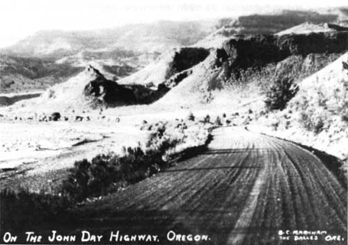
Fig. 31. Postcard depicting the John Day
Highway, graded and graveled, n.d. (City of Fossil Museum).
By 1914, an improved road was built from Biggs on the Columbia River via Condon into Fossil — the same year the first gasoline pump was installed at Fossil's General Mercantile. Over the next few years, with state funds, this road was continued south down Service Creek, along the north bank of the John Day River through Spray and Kimberly, south along the east bank (bridging over at the Humphrey Ranch), and into Butler Basin along the west bank past the Cant Ranch, now headquarters of John Day Fossil Beds National Monument. A narrow winding stretch of the road was reportedly pushed through Picture Gorge around 1917 (Fussner 1975: 131; Mark 1996; 29, 36).

Fig. 32. Picture Canyon, John Day, 1939
(OHS — CN 023724).
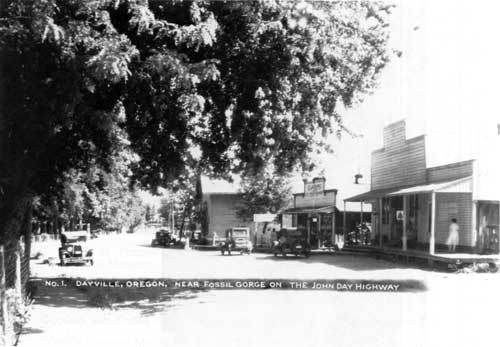
Fig. 33. "Dayville, Oregon, near Fossil
Gorge on the John Day Highway" (OrHi 15142).
This entire segment, from Kimberly to the Mascall Ranch just southeast of Picture Gorge, was clearly in place in 1925 when the U.S. Geological Survey mapped the topography of the Picture Gorge quadrangle. South and east of Picture Gorge, the new highway joined the route of the old Dalles-Boise Military Road, continuing east through Dayville and on to John Day, all the way east to the town of Ontario on the Idaho border.
The John Day Highway (now S.R. 19), laid open the long-secluded country north of Picture Gorge to travelers and tourists alike. The highway also directly linked the still-remote communities of the valley with Columbia River markets. The Oregon State Highway Commission was entirely aware of the commercial value and tourist potential of the new highway when it reported on its progress in the Sixth Biennial Report to the Governor:
The opening of the John Day Highway by completing the gap between Olix and Gwendolen, north of Condon, and surfacing between Spray and the North Fork, has made possible all-year travel into the John Day Valley, with resulting saving to the residents of that region in decreased hauling costs of wheat, wool, etc. The extension of the forest project from Prairie City through Austin to Unity, all of which has been graded and part surfaced, will be the means of opening this entire highway to through travel from Ontario, via the wonderful Picture Gorge and fossil beds, to Arlington, as an alternate route to the Old Oregon Trail (Oregon State Highway Commission 1923-1924: 10).
Oregon's Market Road Act of 1920 apportioned state and county taxes for local routes, allowing the construction of short new road segments and the upgrading of older ones throughout Grant and Wheeler counties. In 1921-22, workmen began limited improvements along the old military road from Antelope to Mitchell, affording travelers better access to the Painted Hills area along Bridge Creek. The north Wheeler County towns of Fossil and Clarno were linked in 1926 with a new market road, later to be designated as part of S.R. 218 (Mark 1996: 29-30).
In the early 1920s, a road from Redmond via Prineville to Mitchell was renamed the Ochoco Highway. Four miles northwest of Mitchell, the road spanned Bridge Creek with a covered, ninety-foot Howe Truss bridge built in 1917. The picturesque bridge remained in place until the early 1950s (Stinchfield 1983: 10). The Ochoco Highway was designated as part of U.S. 28 (now U.S. 26) and was improved through the early 1930s.
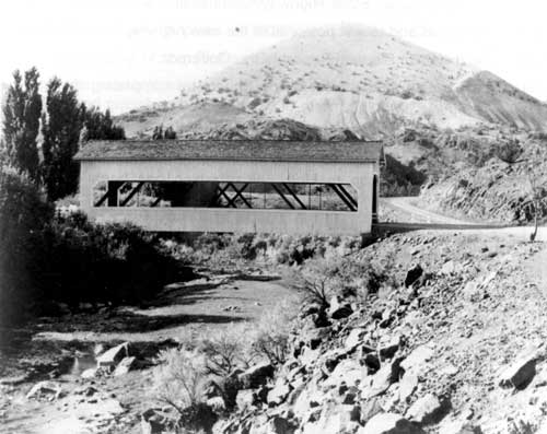
Fig. 34. Covered bridge over Bridge
Creek on Ochoco Highway northwest of Mitchell, n.d (OrHi
100704).
Rerouting of the Mitchell to Dayville segment of the Ochoco Highway — away from old military road alignment through Antone, and north to its present alignment above Picture Gorge — appears to have taken place between 1932 and 1936. The U.S. Geological Survey's 1932 topographic map of the Dayville quadrangle shows the "Mitchell Road" veering off to the west just southeast of the Mascall Ranch, in the approximate location of today's Grant Co. 40. In 1936, however, an American Automobile Association road map shows the new paved segment from Mitchell to Picture Gorge.
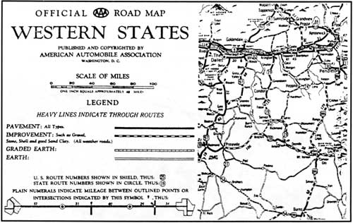
Fig. 35. Portion of Official AAA
Road Map of the Western States, 1936 (American Automobile
Association).
By 1936, most of today's existing state and county roads in the upper John Day basin were in place. With the exception of short paved segments between Mitchell and Picture Gorge, and between Fossil and Condon, roads mapped for motorized travel in Grant and Wheeler counties were "improved" with gravel or sand, and considered "all-weather" in quality. The historic trace from Antelope to Mitchell, along the once heavily traveled military route to Canyon City, soon declined in use and faded from memory.
| <<< Previous | <<< Contents >>> | Next >>> |
joda/hrs/hrs5d.htm
Last Updated: 25-Apr-2002