|
John Day Fossil Beds Historic Resources Study |

|
Chapter Four:
SETTLEMENT (continued)
Settlement Patterns and Land Programs
Several federal land policies shaped the pattern and course of settlement in the John Day watershed. First was the removal of Indian title. This was ultimately accomplished through treaties of land cession with the tribes of the region: Treaty with the Walla-Walla and Cayuse (June 9,1855, ratified March 8, 1859), Treaty with the Nez Perces (June 11, 1855, ratified March 8, 1859), Treaty with the Tribes of Middle Oregon (June 25, 1855, ratified March 8,1859), Treaty with the Nez Perces (June 9,1863, ratified April 27, 1867), and Treaty with the Snake (August 12, 1865, ratified July 5, 1866). These agreements ceded millions of acres to the United States and provided for reservations or the removal of tribes to other existing reservations (Kappler 1904: 694-698, 702-706, 714-719, 843-848, 876-878).
Pivotal among the federal land programs in the John Day region was the massive government grant of hundreds of thousands of acres to The Dalles-Boise Military Wagon Road Company. In 1874, that firm and its successor purchasers formally secured odd-numbered sections, three square miles to either side of each mile of road right-of-way. This cut a swath through the John Day region, including portions of present-day Monument lands. The company wanted to sell some lands and hold onto others. Its policies clearly impacted where and when people would settle, for it controlled the price, acreage, and date of sales.
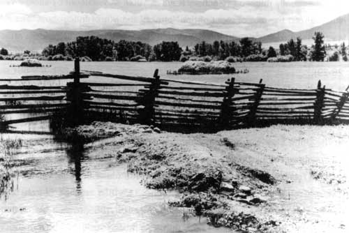
Fig. 12. Fertile bottomlands near
Prairie City secured by owners of grant to The Dalles-Boise Military
Road, ca. 1910 (OrHi ODOT 2186H).
In general, the United States followed an increasingly generous land policy in the nineteenth century and, by mid-century, Congress engaged in outright give-aways of the public domain. The creation of military bounties was an old system that had emerged during the colonial period and continued. It was a means for the government to pay soldiers who had served the public interest in time of war. The War of 1812 and the Mexican War both led to laws which promised lands to veterans. The Act of 1847 permitted the issue of warrants to individuals for 40 or for 160 acre parcels. These warrants, along with old ones outstanding from the War of 1812, were dumped onto the market and discounted, encouraging speculators as well as veterans to move west. The Bounty Land Act of 1850 granted 80 to 160 acres to officers and soldiers who had served four to nine months, or who had served in wars since 1790 but had not previously secured a land grant (Gates 1968: 173-174; 270-272).
The Homestead Act of 1862 entitled any person who was head of a family or twenty-one years old (citizens, or those who had made a declaration of citizenship intent) to file on 80 acres at $2.50/acre or 160 acres at $1.25/acre. The claimant had to pay a $10 filing fee and two subsequent fees each of $4. If this person met the terms of proof, namely that they resided on the land and it was surveyed by the General Land Office, between the fifth and seventh year they could secure title merely for the fees. If claimants wanted to expedite the patent, they could pay the acreage fee and, if the land was surveyed, obtain the deed. Paul Gates, historian of federal land laws, commented: "The Homestead Act breathed the spirit of the West, with its optimism, its courage, its generosity and its willingness to do hard work ..." (Gates 1968: 394-395).
If a person wanted to speculate in land, or anticipated its immediate development and wanted to subdivide it, the General Land Office would sell public lands at $1 .25 per acre to cash purchasers. In a sense then, the cash entry system, the Homestead Act, and grants to military wagon roads and railroads worked in competition. Wagon road companies had to set their land prices at affordable rates. Since their grants were part of a vast checkerboard of alternate sections, their routes opened to settlement government lands as well as their own. This proved a mixed blessing for those seeking profits (Gates 1968).
The largess of Congress continued. The General Land Office used another measure for settlers on the Columbia Plateau to obtain land. The Desert Land Act (1877) permitted filing on up to 640 acres of non-timbered, non-mineral land not producing grass. Claimants paid $.25 cents an acre on filing and, within three years, if they could prove they had irrigated the land, they could secure title by paying another $1.00 an acre. In time 159,704 claimants filed on 38.2 million acres under the law; the General Land Office issued deeds to 8.6 million acres under the law in Oregon and the other ten western states where it applied (Gates 1968: 401).
The Enlarged Homestead Act (1909) permitted settlers to file upon an additional 320 acres beyond their initial claim. The rationale was to help create farms in arid regions of sufficient size to sustain livestock operations (Gates 1968: 504-505).
The Stock Raising Homestead Act (1916) permitted filing on an additional 640 acres of the public domain. The argument driving this law was that most of the prime lands had already been taken but to survive and prosper, stock raisers needed a larger land base. The law permitted filing on land "chiefly valuable for grazing and raising forage crops" and not susceptible to irrigation from any known source. Within its first decade of operation in the American West, the law attracted 114,896 claimants who filed on 45.6 million acres (Gates 1968: 516-520).
Through its various land programs, Congress encouraged sustained Euro-American settlement in the John Day basin. It passed laws which facilitated the development of range industries, and it gave generously from the public domain to encourage raisers of cattle, sheep, and horses to try their fortunes in the John Day watershed. (Anonymous 1902: 394). Bureau of the Census records on the course of agricultural development in the John Day watershed document a steady build-up of farm acreages between 1870 and 1950. In the latter half of the twentieth century, there were declines in the numbers of acres in farms because some owners abandoned farming as an activity and some reforested their lands and moved from grazing into timber production.
Table 2. Acreage in Farms, Grant and Wheeler Counties
| 1870 | 1890 | 1910 | 1930 | 1950 | 1979 | 1987 | |
| Grant County | 18,177 | 199,590 | 445,170 | 899,329 | 1,074,351 | 1,072,852 | 1,020,786 |
| Wheeler County | NA | NA | 415,576 | 688,056 | 819,400 | 729,800 | 766,422 |
(Bureau of the Census 1895, 1913, 1952)
The actual number of farms in Grant and Wheeler counties increased until 1910 and then began a generally downward trend. An important part of the trend was the consolidation of holdings. Persons with capital bought out owners of small farms and consolidated the acreage into larger management units.
Table 3. Number of Farms, Grant and Wheeler Counties
| 1870 | 1890 | 1910 | 1930 | 1950 | 1979 | 1987 | |
| Grant County | 99 | 624 | 773 | 632 | 426 | 286 | 402 |
| Wheeler County | NA | NA | 387 | 284 | 189 | 110 | 130 |
(Bureau of the Census 1872, 1895, 1913, 1932, 1952)
| <<< Previous | <<< Contents >>> | Next >>> |
joda/hrs/hrs4d.htm
Last Updated: 25-Apr-2002