

|
SARATOGA National Historical Park |
 |
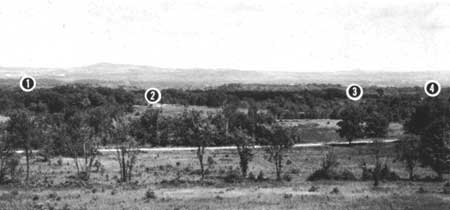
View east from Fraser's Hill with the Hudson
Valley Hills and Green Mountains in the distance, showing the terrain
held by the British line and the ground most bitterly fought over in the
battle of October 7. On the bluffs overlooking the river is the site of
the Great Redoubt (1) where Fraser was buried and from where the British
began their retreat northward to Saratoga (now Schuylerville). The
Breymann Redoubt (2) was in the cleared area adjacent to the woods. The
Freeman Farm (3), where the battle of September 19 began, was later
included within the British lines. The Balcarres Redoubt ran from the
Freeman Farm right to (4).
Guide to the Park
Saratoga National Historical Park is an area of exceptional scenic beauty, the terrain of the park being characterized by sharply rising bluffs, deep ravines, and rolling hills. Its present open clearings are in sharp contrast to its heavily wooded appearance in 1777.
Though time has left few vestiges of the American and British fortifications, an effort is being made to establish definitely their original character and position by historical and archeological research.
THE AMERICAN RIVER REDOUBTS. The river bluffs on which American batteries were emplaced dictated the tactics of both armies and the course of the two battles of Saratoga. The American line was anchored on these bluffs, because here the high ground converged with the river to allow only a narrow corridor along the river plain. The road south to Albany ran through this corridor. Both battles were fought as a result of the British attempt to flank the American positions controlling this passageway. This terrain factor must be appreciated if the course of events at Saratoga is to be understood.
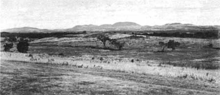
View looking northeast from the site of Fort Neilson, a key point
dominating the left flank and center of the American defensive
position.
SITE OF FORT NEILSON. Situated on the crest of Bemis Heights at the apex of the American line, stood Fort Neilson. In reality the fort was a fortified barn, named for John Neilson, the farmer who owned it. Strengthened on either side by heavy batteries and protected by a breastwork of logs and felled trees, the fort constituted a key point in the American line. The overlook from this point offers a sweeping panorama of exceptional beauty and charm. From here are visible the Adirondacks, the Green Mountains in Vermont, the Berkshires in Massachusetts, and the Catskills.
Now standing on the site of Fort Neilson is the Block House containing relics of the Revolutionary period and exhibits designed to present the story of the Battles of Saratoga and the Burgoyne Campaign.
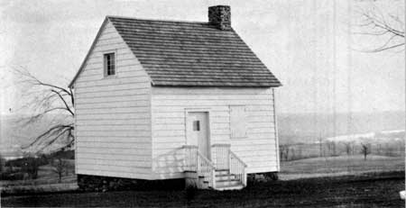
The John Neilson House. This structure, situated on Bemis Heights, is
the only contemporary building remaining on the battlefield.
THE NEILSON HOUSE. Located within the fortified area of Fort Neilson, the Neilson House is the only contemporary building still standing on the battlefield. This house, the home of John Neilson, served as the quarters of Generals Benedict Arnold and Enoch Poor. From this building Poor went to lead his troops in gallant action on both September 19 and October 7. It was to this building that Major Acland, of the British Grenadiers, was brought severely wounded on October 7; and it was also to this building that Lady Acland, in defiance of great hardships, came to nurse her wounded husband. The smoked walls, planked floors, and rough period furniture preserve much of the Revolutionary atmosphere.
AMERICAN POWDER MAGAZINE. On the little plateau east and below the site of Fort Neilson, near the center of the American line, is located a reconstructed stone powder magazine. From the report of Ebenezer Stevens, Major Commandant of Artillery, entitled, "Return of Ordnance and Stores in Camp near Stillwater, September 24, 1777," with a subheading, "Stores in Magazine," it has been possible to determine the exact character and quantity of the supplies located within the magazine.
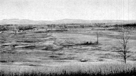
View of the Freeman Farm from the east, showing
the scene of the heaviest fighting of the Battles of
Saratoga.
FREEMAN'S FARM. No part of the battlefield witnessed heavier fighting than the area known as Freeman's Farm. Around this farmhouse and its oblong clearing of 15 acres, the swirling tides of battle beat relentlessly in the engagements of both September 19 and October 7. The original Freeman farmhouse, owned at the time of the battles by Isaac Leggert, occupied approximately the site of the present building by that name. Following the battle of September 19, it was included within the fortification known as the Balcarres Redoubt. The oblong clearing ran east and west across the same small ridge on which the Freeman house stood.
BALCARRES REDOUBT. Situated on the same ridge as the Freeman farmhouse, the Balcarres Redoubt extended approximately 500 yards in a north-south direction. The redoubt was an enclosed work mounting eight cannon, with walls from 12 to 14 feet in height and constructed of logs with earth thrown over them. The front of this work was covered with a strong abatis built of felled trees. The Balcarres Redoubt thus constituted the strongest fortification of the British line. Under the command of the Earl of Balcarres, the fortification was erected shortly after the Battle of September 19 and was occupied by the British Light Infantry. In fierce attacks, the American forces, on October 7, repeatedly assailed this redoubt in vain. Arnold's successful assault on the Breymann Redoubt, however, finally served to outflank the position and force its evacuation.
BREYMANN REDOUBT. The Breymann Redoubt was situated on the extreme right flank of the British line and was erected to defend the right flank of the Balcarres Redoubt and to cover a road that ran from this point to the American camp. The Breymann Redoubt thus served as the key to the entire British position. The redoubt was constructed and defended by German troops, under command of Lieutenant Colonel Breymann, shortly after the battle of September 19. It consisted of a single line of breastworks, approximately 200 yards in length, with short flank defenses and no works in the rear. On the right, on high ground, it mounted a battery of two cannon that was captured by the Americans on October 7. The ground before the redoubt was cleared and there was no abatis before this work. The walls of the redoubt were constructed of logs and rails. The logs were laid horizontally one upon the other and were supported between upright pickets, or posts, driven into the ground on either side of the wall and fastened together at the top. The breastwork was between 7 and 8 feet in height, with an opening of about 9 or 10 inches wide, at a suitable height for small arms. It was here in the closing hours of October 7 that Arnold took part in the dramatic assault that sealed the fate of the Burgoyne Campaign. The unique monument to Arnold's wounded leg is located on the site of the Breymann Redoubt.
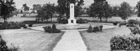
This shaft was erected in 1931 by the Daughters of the American
Revolution of New York State as a memorial to the American soldiers who
died at Saratoga.
FIRST LINE OF BATTLE, OCTOBER 7. Situated approximately three-fourths of a mile northwest of the site of Fort Neilson and extending some 1,000 yards west of present State Route 32, is the position which the flanking column of 1,500 soldiers under Burgoyne occupied at the beginning of the American attack on October 7. Here on the southern slope of the rise of ground, just north of the Middle Ravine, the British met the full fury of the first American attack. It was in this area that General Fraser received his mortal wound and many other British officers were killed, wounded, or taken prisoner before Burgoyne ordered a retreat to the Balcarres Redoubt. The badly wounded Major Acland, commander of the British Grenadiers, and Major Williams, commander of the British Artillery, were both taken prisoners by the Americans in this area on October 7.
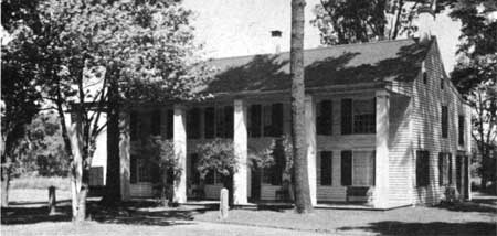
The Schuyler House. The main part of this building
was erected by Gen. Philip Schuyler to replace an earlier house, which
was burned by Burgoyne's troops on October 10, 1777. The house, situated
in Schuylerville (Old Saratoga), is being restored to the period of
Schuyler family occupancy.
THE GEN. PHILIP SCHUYLER PROPERTY. Situated at Schuylerville (Old Saratoga), N. Y, this estate was the summer residence of Gen. Philip Schuyler both before and after the Battles of Saratoga. The present house was erected in 1777 by General Schuyler shortly after the surrender of Burgoyne's army. It stands near the site of his former home which was burned by Burgoyne. Restoration to the period of occupancy by the Schuyler family is under way, with further studies yet to be completed. The structure is a 2-story frame house, 60 feet long by 21 feet wide. The walls are filled in with brick. There are seven spacious rooms on the first floor and, in addition, a large kitchen. On the second floor there are seven bedrooms in the main part of the house and four more over the kitchen. Gen. John Stark, George Washington, Governor Clinton, and Alexander Hamilton were guests of the Schuylers in this house.

|

| History | Links to the Past | National Park Service | Search | Contact |
|
Last Modified: Mon, Dec 2 2002 10:00:00 am PDT |