

|
SCOTTS BLUFF National Monument |
 |

Scotts Bluff from the Mormon Trail.
Courtesy, Downye's Midwest Studio, Scottsbluff, Nebr
Guide to the Area
Location of the Monument. Scotts Bluff National Monument adjoins the south bank of the North Platte River, in Scotts Bluff County, western Nebraska, 3 miles west of Gering via State Route 86, and 4 miles southwest of Scottsbluff which is on the north side of the river, on U. S. 26. The highway route on the north side of the North Platte River from Broadwater to the city of Scottsbluff in part parallels the course of the Mormon Trail. If you approach this historic landmark from the east, you can follow the classic Oregon Trail route to this point by driving up the North Platte Valley via U. S. 26 from Ogallala through Bridgeport (Courthouse Rock) to South Bayard (Chimney Rock) and State Route 86 from South Bayard to Gering.
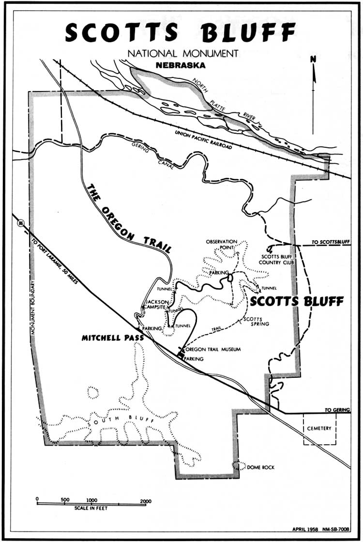
(click on image for larger size)
Trans-Monument Road. The monument area is bisected from east to west by State Route 86, the principal approach being from the east through Gering. The Mitchell Pass route of the old Oregon Trail coming in from the east to the north of Dome Rock intersects this highway just south of the east entrance to Scotts Bluff National Monument. From this entrance to monument headquarters, the high way roughly follows the roadbed of the old Oregon Trail. Near monument headquarters, remains of the trail swing south of the highway before recrossing it to make the ascent through Mitchell Pass, which separates South Bluff from Scotts Bluff proper.
Mitchell Pass Area. At the crest of Mitchell Pass, State Route 86 continues westward through Mitchell Valley to the Wyoming State line. From the pass, the trough of the Oregon Trail makes an abrupt hairpin turn to get around the head of a ravine, then veers northwestward toward the North Platte River, and the old crossing at the mouth of Horse Creek, near present Lyman, Nebr. In Mitchell Pass and a few hundred yards west thereof, the Oregon Trail trough is exceptionally well-defined despite the passage of nearly 100 years since it was heavily traveled. The unusual depth of the old trail through this area results from the fact that the countless thousands of animals and wagons had to go single file through the Mitchell Pass bottleneck. There is a trail from the Mitchell Pass parking area to the William H. Jackson campsite marker.
Visitor Center. The dominant building at the monument headquarters area, just east of Mitchell Pass, is the Visitor Center, which houses the Oregon Trail Museum and monument administrative offices. The principal features of the museum are: (1) The entrance lobby, adorned with bronze Oregon Trail and Pony Express plaques; (2) the main History Room, featuring exhibits relating to Scotts Bluff and the Oregon Trail from earliest explorations to the open range cattle industry; (3) the William H. Jackson Memorial Room, containing a collection of Jackson's Oregon Trail sketches and watercolor paintings, together with two dioramic scenes of frontier buffalo hunting; and (4) the Prehistory Room, with displays describing the geologic formation of Scotts Bluff, its paleontological (fossil) story, and the prehistoric Indians of the North Platte Valley.
Uniformed personnel are stationed at the Visitor Center throughout the year. Seasonal public services include orientation talks in the museum rooms and at the summit of Scotts Bluff; evening illustrated talks in the museum courtyard; and guided hikes over the Oregon Trail and over the Summit-Museum Trail. Free informational literature and sales publications of special historical interest, and signs, markers, and wayside exhibits are available throughout the year.
Scotts Bluff Summit Road and Summit Area. During the 1930's, a paved road 1.7 miles in length, requiring three tunnel excavations, was built from the monument headquarters area to the summit, to enhance visitor appreciation of the bluff's scenic and historic values. The road leads to a 50-car parking area on top. At the Summit Road entrance gate, adjoining the Visitor Center, cars are welcomed by a uniformed ranger. There is a fee collected here for use of the Summit Road, which is open daily except when weather conditions make driving hazardous.
The summit area is several acres in extent. Surfaced trails reach the principal overlooks. The main trail proceeds north from the area to the High Point of the bluff (4,649 feet above sea level), then meanders to the Observation Point above the north face of the bluff. At the foot of the bluff are the scenic badlands and the North Platte River, while the historic North Platte Valley stretches to the horizon east and west. An orientation map and bronze indicators will enable you to trace the route of the Oregon and Mormon Trails through this valley, and to determine the direction of the following points of interest: Courthouse Rock, Chimney Rock, Castle Rock, Rebecca Winters' Grave; Agate Springs Fossil Quarries, Fort Mitchell, Fort Laramie, and Laramie Peak.
A trail south from the parking area will enable you to reach a point overlooking the Visitor Center, Mitchell Pass, and the beginning loop of the Summit Road. Beyond Dome Rock is Gering Valley, through which was the Robidoux Pass route of the Oregon Trail.
Summit-Museum Trail. A feature of the monument which affords extra scenic and inspirational benefit is a 1.6-mile-long trail extending from the summit to the headquarters area via a series of zig-zags and ledges, a foot tunnel, and "Scott's Spring." Not only does this trail afford superb scenic views of the bluff, it enables you to examine at close hand the successive rock strata that comprise the bluff, and to walk through varyingly vegetated slopes and fields. Descent of the bluff on foot by this trail is a popular activity. There are those who arrange to have someone in their party drive the car back down to the headquarters area, while others make the round trip by foot.
Badlands Area. The section between the steep bluff and the river is characterized by a tortuous labyrinth of steep-sided gullies known as "badlands." The badlands area is of historical interest since it was the impassability of this ground that forced the earliest emigrants on the trail to detour away from the river, first through Robidoux Pass, and later through Mitchell Pass. The badlands are also of exceptional geologic interest as an example of rapid erosion in soft rock beds of comparatively uniform composition. There is a natural bridge in one of the ravines. The area is of special interest paleontologically be cause of the wealth of Oligocene fossils to be found there. A graveled road within the monument boundaries follows the Gering Canal through the badlands area. This can be reached via the road to Scotts Bluff Country Club, at the east foot of the bluff.
South Bluff Wild Area. The area within the monument south of Stare Route 86, including Dome Rock and the South Bluff, is unimproved and no improvements are planned. This is a relatively unspoiled area of considerable scenic value, abounding in features of geological and botanical interest. You are free to ascend South Bluff or roam on foot through this area on either side of Mitchell Pass; however, no fires or overnight camps are permitted. Rough clothing and stout footgear are recommended. Climbing of Dome Rock is extremely perilous, and is discouraged because of the crumbly nature of the Brule clay formation that makes up its steep walls.

Visitor's on the Oregon Trail West of Mitchell Pass.
Nearby Chimney Rock National Historic Site is preserved by cooperative agreement between the Department of the Interior, the Nebraska State Historical Society, and the City of Bayard, Nebr. Included in the National Park System are these other areas commemorating phases of early western history: Jefferson National Expansion Memorial, Mo.; Homestead National Monument, Nebr.; Fort Laramie National Monument, Wyo.; Grand Teton National Park, Wyo.; and Whitman National Monument, Wash.
Scotts Bluff National Monument was carved out of the public domain by Presidential proclamation on December 12, 1919, and contains more than 5 square miles. A superintendent, whose address is Box 136, Gering, Nebr., is in immediate charge.

|

|

| History | Links to the Past | National Park Service | Search | Contact |
|
Last Modified: Sat, Dec 9 2000 10:00:00 am PDT |