

|
FORT NECESSITY National Battlefield |
 |
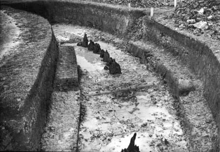
Excavated trench showing post ends in place.
Discovery of the Original Fort
Faced with the problem of replacing posts, many of which had become badly deteriorated since the erection of the stockade in 1932, the National Park Service, in 1952, first made a restudy of all available records bearing on the location and shape of the original fort and trenches. Then, a thorough archeological analysis of ground evidence was made, the results of which might establish definitely the type of fort and the kind, as well as the location, of trenches constructed by Washington's force in 1754.
While it could be reasonably concluded, on the basis of Washington's several references to the fort and stockade during the process of construction, that the enclosure was small and could be defended from entrenchments built near it, two documents lend particular weight to the hypothesis that the stockade was small and round in shape. In 1952, a deposition by John B. W. Shaw, who saw action at Fort Necessity, was discovered. Shaw, a member of the Virginia regiment, described first the actual fighting and then gave a realistic picture of the fort as a defense position. "There was at this Place," he relates, "a Small Stocado Fort made in a Circular form round a Small House that Stood in the Middle of it to keep our Provisions and Ammunition in, And was cover'd with Bark and some Skins, and might be about fourteen feet Square, and the Walls of the Fort might be eight feet Distance from the said House all Round." Shaw's description of the action at Fort Necessity ties in closely with Washington's account.
Shaw's statement concerning the fort, which apparently was based on reasonably close examination, is supported by the observation of Col. James Burd 5 years later. In 1759, Colonel Burd, in charge of a road-clearing force of 200 men, preparing to open a new road from Chestnut Ridge to Redstone, noted in his diary of September 10, as he passed Fort Necessity, that he "Saw Col. Washington's fort, which was called Fort Necessity. It is a small circular stockade, with a small house in the center; on the outside there is a small ditch goes around it about 8 yards from the stockade. It is situate in a narrow part of the meadows commanded by three points of woods. There is a small run of water just by it." In view of the reference by Colonel Burd in 1759 to "a small circular stockade," it is possible that Burd based his statement partly on his observation of the existing mounds and partly on hearsay from settlers who had seen the stockade. It is of importance to note, however, that certain observations made by Burd corroborate the testimony of the eyewitness, John Shaw, contained in his deposition a few months after the battle.
On the basis of documentary evidence and previous explorations of the mounds, the National Park Service in the summer of 1952 made additional excavations to locate the "outer trenches" to which the Washington and Shaw accounts referred. After careful examination of the 1932 fill and earlier layers of soil, no evidence was found indicating that the trenches occupied by the South Carolina troops lay beyond the mounds of the existing fort outlines. Trenches were dug also on the interior of the stockade which, beyond indicating the original grade to be from 8 to 12 inches below the 1932 fill, disproved the existence of the long side of a triangular fort as advanced by the Lewis survey of 1816.
On the premise that the original fort was a small circular stockade, as indicated by the statements of John Shaw and Colonel Burd, and that the stockade constructed in 1932 was located approximately on the line of the original entrenchments, further excavation was undertaken during the spring and summer of 1953. As Burd had referred to a stream near the stockade and since pieces of the stockade had been discovered in the excavations of 1901 and 1932 near the stream in the northern area of the existing stockade, trenches were sunk in this area at an angle which would bisect a circle approximately 52 feet in diameter.
On the first day of excavating, the 3-foot-deep trench on the western perimeter of the hypothetical line revealed a large piece of wood, identified as one of the posts of the original stockade. The extension of the trench to the southern perimeter revealed a line of post ends, approximately 2 feet below the 1754 ground level, in a circular position. The earth adjacent to the posts was clearly the back-fill of soil for the support of the posts after they had been placed in position. Excavation along the course of the original trench, which could be readily followed, was extended eastward, revealing additional post ends in a circular outline. As the project neared completion, a sufficient number of post stubs had been found in their original position to determine definitely the construction details of the fort. The stubs represented the portion or the posts that stood below the ground-water level and were preserved because they had been continuously wet.
Archeological discoveries proved conclusively that the original stockade was circular in shape, measuring 53 feet in diameter. The overall perimeter was 168 feet, and the entrance, located on the southwest sector of the stockade, was 3.5 feet wide.
With the shape and location of the original stockade established, exploratory trenches were dug across the presumed location of the original outer entrenchments. Clearly defined cross sections of the trench on the back, or inner, side of the earthworks were secured. Sufficient information was obtained, therefore, to make possible a faithful restoration of these defense mounds.
Artifacts discovered in the 1953 excavations were similar to those found in the explorations of 1901 and 1932. Of first importance in the more recent excavations were the preserved post ends. Other artifacts included numerous lead musket balls, mostly of French caliber (.69); gun flints; small iron balls; clay tobacco-pipe fragments; the brass tip of a sword scabbard; a large bolt, possibly belonging to the gate; and a brass button.
Although archeological evidence of a small house, known to have been situated near the center of the stockade, was not found, a small log structure typical of the period has been erected to complete the restoration.

|

| History | Links to the Past | National Park Service | Search | Contact |
|
Last Modified: Mon, Dec 2 2002 10:00:00 am PDT |