An Administrative History

|
GUADALUPE MOUNTAINS
An Administrative History |
|
CHAPTER VI: PLANNING FOR THE PARK--THE 1970S (continued)
Master Planning Process (continued)
Master Plan
Figure 16 shows the major components of the plan that was approved in 1976 for development of the park. The primary visitor center for the park, located at Pine Springs, would provide parking, food service, restrooms, interpretation, and orientation. Pine Springs also would be the lower terminus for the tramway to Guadalupe Peak. The upper terminus, just below the summit, would have a shelter, orientation devices, and a staffed contact station. From Guadalupe Peak visitors would have spectacular views of the high country, the salt flats, and the desert. During the ride to the summit, visitors would learn of the geological significance of the fossil reef and the various biological life zones represented in the park. From Guadalupe Peak, visitors who wished to do so could enter the wilderness area. [10]
|
|
The west side of the park would be developed for low-density use. Cooperation with the Texas highway department would be necessary to provide an access road to this part of the park. Visitor access would be controlled, entrance fees collected, and information services provided from an entrance station on the west side. A park road, traversing part of the length of the west side of the park, would connect on the western boundary with a county road leading to Dell City. Near this junction, a primitive campground and parking area would be located. A spur road would lead from the park road to Williams Ranch. [11]
Access to the parking area at the mouth of McKittrick Canyon would be by road and private automobile. Guided foot trips into the canyon, lasting approximately three hours, would interpret geology and the riparian and aquatic communities. An interpretive center would provide information about the canyon for visitors who do not take the tour. [12]
The high country would be reserved for wilderness-type experiences. Hikers would have access to the high country from three main trailheads: the main trail, originating near Frijole and leading up Pine Springs Canyon; a secondary trail originating in the northwest corner of the park; and, another secondary trail beginning in Dog Canyon, with a primitive campground at the trailhead. The trail system would connect with a ridge trail following the McKittrick Canyon divide. Development of the Dog Canyon trail and campground would depend upon the county providing an access road to the area. [13]
The planners recognized the need for camping facilities for park visitors. While providing for a temporary campground at Pine Springs Canyon, the planners expected that private enterprise would develop permanent campgrounds near the park. The plan provided, however, that if such developments did not occur within five years after approval of the Master Plan, the Park Service would construct campgrounds within the park. [14]
The Master Plan proposed various forms of management for the resources of the park. Geologic features would be preserved by prohibiting destructive or obstructive development. Flora and fauna would be actively protected by neutralizing the influence of humans. Water for human use would be obtained only where its extraction would not be detrimental to the park. Visitation to McKittrick Canyon would be controlled and horse use prohibited in the lower canyon. Use of the Bowl would be concentrated on the edge of the relict forest, which would be interpreted for visitors as a "museum object" and for scientists as a "laboratory" for approved research. In the primitive areas, day use would predominate; overnight horse trips would be prohibited. The trail system would be designed to avoid fragile areas. Historic resources already identified, including Williams Ranch, Frijole Ranch, and the Pinery Stage Station would be preserved; other historic and archeological sites would be preserved until fully evaluated. The plan also classified the park lands into five categories to aid management decisions: developed areas, buffer areas, research (delicate) areas, primitive land, and historic and cultural sites. [15]
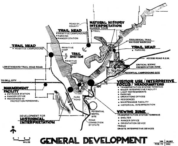
Figure 16. The general plan for development of Guadalupe Mountains
National Park, as set forth in the Master Plan approved in 1976.
The Master Plan set forth the administrative facilities necessary for the operation of the park. It provided for residences and maintenance facilities at Pine Springs; a contact station, maintenance facility, and residence on the west side; and a ranger station at Dog Canyon. To provide access to McKittrick Canyon, an exchange of right-of-way would be required. [16]
Finally, the Master Plan outlined management objectives for visitor use and resource management. The planners desired that all visitors be able to see the park from the high country as well as from below and that the modes of access to these points be within the physical and financial capabilities of the majority of visitors. Interpretation would focus on geology, the unique ecosystems found in the park, and the historic resources. Development in fragile areas would not take place until research was completed showing there would be no adverse effects on the natural resources located there. The water needs of native plants and animals would be met before human uses were developed. Fire would be utilized as a management tool. [17]
CONTINUE >>>