An Administrative History

|
GUADALUPE MOUNTAINS
An Administrative History |
|
CHAPTER V: MINERAL RIGHTS AND LAND ACQUISITION (continued)
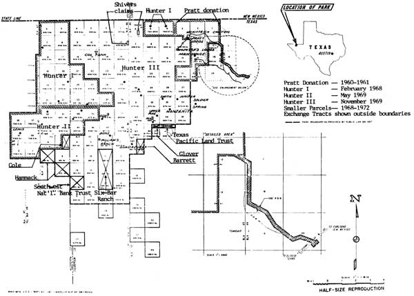
Acquisition of the J. C. Hunter, Jr., Land
Once Texaco and the State of Texas had donated their mineral rights to the Government, acquisition of surface rights began. According to the Offer to Sell Real Property executed by J. C. and Mary Hunter on August 26, 1966, the federal government had an 18-month option, expiring February 26, 1968, to buy Hunter's 71,978 acres for $1,500,000. Hunter hoped to complete the sale by June 30, 1968, and was reluctant to hold his price any longer than that. [6]
The first Congressional appropriation for land acquisition for Guadalupe Mountains National Park was only $280,000, considerably less than Hunter's sale price. In October 1967, Thomas Kornelis, Chief of Land and Water Rights for the San Francisco Service Center, began negotiating with Hunter about buying his land in two or three parcels. Hoping to make the best possible use of the $280,000 appropriation, Kornelis and Howard Cameron, a Park Service Realty Specialist, proposed using the appropriation to purchase Hunter's tracts of land outside the park boundary, tracts that had been authorized by the park bill to be used as exchange property. These tracts would then be offered to the landowners who held smaller pieces of property within the park boundary. Assuming everyone was willing to accept an exchange, the federal government then would have only one landowner, J. C. Hunter, Jr. to tie to a firm price. [7]
Hunter realized nothing could be done to avert the piecemeal sale of his property, but he sought to protect his interests in some way. Refusing to sell any but the least desirable portions of his property first--the western and southernmost sections--he also asked that no negotiations be made with the smaller landowners until the government actually owned the lands that would be exchanged. [8] Hunter's requests were met. In February 1968, Hunter deeded 14,007.6 acres of his property to the federal government for $280,000. Except for two sections on the northern boundary of the park, which were adjacent to the Pratt donation, the land was all on the west side of the Guadalupes.
Appropriations for the fiscal year of 1969 were even less than before. The House Appropriations Committee vetoed any funding whatsoever, but Senator Yarborough managed to convince the Senate committee to appropriate $205,000, an amount with which the House eventually concurred. Kornelis again approached Hunter and once again Hunter refused to sell any land but sections on the west side, south of the previous tract. However, he agreed to sign a contract for the purchase of the remainder of the property contingent upon the availability of funds in 1970. In May 1969, for $205,000, Hunter conveyed to the federal government an additional 9,773.25 acres of the ranch. At the time of this transaction, Hunter gave immediate possession of the tract to the Park Service, but he reserved a six-month period of possession after the sale of the remaining tract in order to allow his long-time foreman and ranch resident, Noel Kincaid, to move his ranching business. [9]
A special appropriation from the general fund of the Interior Department made possible the acquisition of the third tract of Hunter's land. Hunter deeded the final 48,290.55 acres of his ranch to the government on November 20, 1969, for $1,015,000. The sections of land outside the park boundary to be used for exchange with other landowners were a part of this transaction. On December 10, 1969, in a letter to Neal Guse, Superintendent of Carlsbad Caverns, Hunter acknowledged receipt of the final payment for his property and waived his six-month right of possession, stating that Kincaid was no longer in his employ. [10] The government acquired the Guadalupe Mountain Ranch, 72,071.40 acres comprising more than 90 percent of Guadalupe Mountains National Park, for a total of $1,500,000. Figure 14 summarizes the Hunter acquisitions and shows the other individual tracts in the park.
|
|
CONTINUE >>>