|
GRAND PORTAGE
A Report on Archeological Investigations Within the Grand Portage Depot (21CK6), Grand Portage National Monument, Minnesota: The Kitchen Drainage Project |

|
FIELD INVESTIGATIONS
METHODS
Since numerous excavation projects had been carried out by various investigators, it seemed most prudent to pattern the 1989 research methods after those that had been used in previous years. Accordingly, certain departures were taken from the usual Midwest Archeological Center field practices. Most notably, excavations were performed using the English system of measurement, rather than metric linear units.
The first order of business in 1989 was to establish an excavation grid conforming to that followed since 1936. Records relating to the early excavations at Grand Portage, however, are sketchy and at times conflicting. In fact, the primary authority on Grand Portage archeology, Alan R. Woolworth, provides two different accounts of where the East-West baseline was located.
In his summary of the 1936-1937 excavations, Woolworth (1963:36) first states that the East-West baseline "was parallel to and about 23.7' west of the western wall of the Great Hall." Later in that same report, however, while discussing Trench No. 1, Woolworth (1963:49) writes (emphases added):
This N-S trench was four feet in width. It was located parallel to the E-W baseline, but five feet west of it. It was also parallel to the western wall of the Great Hall, but about 23.5' west of it.
Given those figures, simple arithmetic concludes that the East-West baseline should be located 18.5 ft from the Great Hall foundation.
Examination of plan maps reproduced in Woolworth's report suggest that the former figure (23.7 ft) must be incorrect and may refer to the location of Trench No. 1, rather than the East-West baseline. Unfortunately, no precise directional bearing is given for the line, other than the statement that it ran parallel to the western Great Hall foundation. Measurement of the angle shown on Woolworth's (1963) Map 11, however, indicates an approximate bearing of 142° east of magnetic north.
In light of those data, we established a grid line 18.5 ft from the western foundation of the Great Hall and 142° east of north. All east and west Cartesian coordinates used in 1989 are relative to that baseline. This proved to be a convenient referent for our excavations, since it trended in the same general direction as the existing drainage line installed during 1975. Furthermore, the original 1936 East-West baseline, which we believed this line replicated, passed directly through the center of the fur trade structure presumed to lie now in the path of the proposed drain.
It was not possible in the time allotted to re-establish the North-South baseline with any confidence. Although its position is described by Woolworth (1963:35-36), an accurate survey of the Depot with its present interior structures could not be readily achieved in the brief time available. The probable position of the former "center wall" that corresponded with the baseline could have been approximated, but since it would have been an approximation another arbitrary point was chosen as the referent. That zero point is the southwest corner of the Great Hall's front porch. For purposes of our 1989 investigations, all grid measurements north and south are made relative to that fixed feature.
The standard excavation unit employed in the 1989 field investigations was a 5 ft x 5 ft square. Although smaller units would have enabled more extensive coverage of the construction zone, they would be more likely to miss exposing cultural features. Furthermore, since the trench was to be as much as 8 ft wide at its top, five-foot squares could be positioned in such a way as to examine slightly more than half of the impact zone at any given location.
It should be noted here that initial field examination of the project area revealed a discrepancy in the project plans. Although the downslope conduit was to be located along the same path as an existing 1975 drain, its location was not correctly plotted on the plans. Comparison of the drawings with the drain's obvious linear surface depression indicated a difference of some 15 ft where the line met the lakeshore palisade. Test excavations, as a result, were placed with respect to the intended location of new construction, not the alignment shown on the plans.
Previous research within the Depot demonstrated that approximately 1 ft of relatively recent fill covered much of the area, particularly in front of the Great Hall. The thickness of the fill zone, of course, might vary considerably from that average, but the interface would be clearly recognizable when reached. Accordingly, the fill layer, regardless of its depth below surface, was excavated as a single level. Furthermore, the matrix was not systematically screened, owing to the fact that the fill contained a great deal of modern debris. A sample of materials, however, was collected from each of those initial levels.
After removal of the fill zone, each unit was excavated in arbitrary four-inch levels. Vertical control was maintained by reference to the ground surface at each unit's southwest corner stake. That corner also was employed as the designator for horizontal control; all grid coordinates identifying excavation units refer to the southwest corner stake.
Each level was documented with measured drawings and, if deemed appropriate, with photographic images. Soils removed from the units were screened through quarter-inch hardware cloth in order to facilitate collection of archeological materials. All artifacts recovered were bagged according to provenience for subsequent laboratory processing and analysis. At times, soil anomalies of possible significance dictated collection of discrete zones within levels.
Excavations continued systematically through each unit until no artifacts or soil anomalies were noted. At that point, each unit was declared culturally sterile. Representative unit walls were then photographed and drawn to record their soil profiles. Each unit was backfilled after coring the unit floor with a soil auger to check for deeply buried cultural deposits.
RESULTS
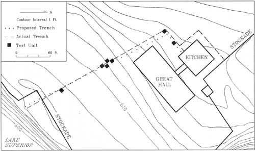
During the two-week field project, seven test units were excavated within the Depot (Figure 5). Four of those, however, fell upon the area where Structure 1 was believed to have been located and partially excavated in 1936. Since little or nothing of real consequence was found in the 1989 excavations, it should not be necessary to dwell upon their contents in any detail. Rather, they will be discussed in more general terms with respect to the three areas represented: the Structure 1 area, the palisade area, and the Kitchen/Great Hall area.
|
| Figure 5. Actual trench placement and locations of 1898 test excavation. |
Structure 1 Area
As noted earlier, the remains of a fur trade era structure were a primary concern of the 1989 investigations. Evidence of that building, which is known alternately as Structure 1 and Feature 12 in the archeological literature, was partially excavated during the initial Grand Portage investigations of 1936. Field records from those earliest excavations indicate that the structure was located a short distance southwest of the Great Hall. Those records, however, do not make clear how much of the structure was left intact by the excavators. Nor are the archeological base maps of a scale that enables precise pin-pointing of the structure's location relative to other features.
According to Woolworth (1963:76-78), Structure 1 was discovered at the intersection of two large exploratory trenches (Trench No. 1 and Trench No. 2) excavated under the direction of G. Hubert Smith. A grid was laid out over the structure later in order to excavate it systematically. Upright posts representing the structure's walls, when delineated, indicated a rectangular form measuring approximately 18 ft x 30 ft with its long axis trending north-south. Associated artifacts suggested that Structure 1 was not a later intrusion within the fur trade Depot, but they did not allow a definitive determination of its age or function.
In fact, Structure 1 has been interpreted differently in at least two separate reports by the same authority. In his summary of the 1936-1937 Grand Portage investigations, Alan R. [...text missing in printed document...] "western wall of this building was six feet east of and parallel to the course of the interior palisade trench." He logically concludes, therefore, that Structure 1 "might have been associated with this palisade line and contemporaneous or later in time." That former palisade is believed to represent the original western wall of the Depot, built circa 1768 (Woolworth 1975:69-70). Therefore, if Structure 1 in fact was erected with reference to that palisade, as its orientation suggests, then the building could not have been constructed before that year.
In his later overview written in collaboration with Nancy L. Woolworth, however, quite a different view is expressed (Woolworth and Woolworth 1982: Vol. 2, Form 12): "It is possible that this is the oldest building at the site, and it is possibly associated with the French fur trade which operated here from c. 1731 to 1760." That line of reasoning is apparently drawn from the fact that the walls of Structure 1 were formed of upright posts set in the ground. Although not exclusive to the French, that manner of construction is certainly typical of their eighteenth-century building practices on the frontier of North America.
Obviously, both interpretations cannot be true. It was hoped that the 1989 investigations might shed greater light on this problem, through the examination of surviving parts of the structure and associated artifacts. But that was not to be. None of the four test units excavated in the vicinity of Structure 1 revealed any evidence of that problematic feature.
Examination of the 1979 Cultural Resource Management Base Map (Woolworth and Woolworth 1982: Map 12, Sheet 2) indicates that the 30-foot long Structure 1 should lie within an area approximately 20 ft to 50 ft southwest of the Great Hall. Further, the East-West baseline re-established in 1989 should pass nearly through the center of the feature. The proposed drainage trench, however, would trend southward some 10 ft west of the baseline in that area.
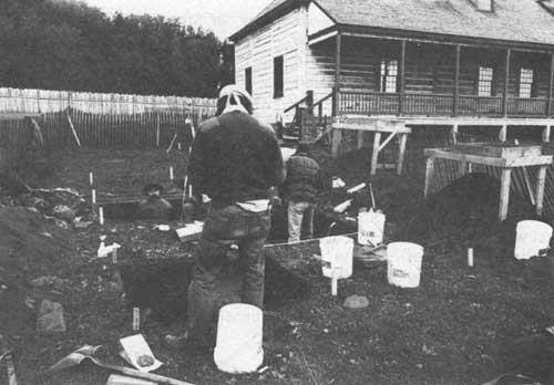
Four 5 ft x 5 ft test units were excavated in the vicinity of Structure 1: S25/W5, S30/W10, S35/W5, S40/W10. Together, the four units formed a checkerboard pattern that enabled the investigators to examine, in effect, a 10 ft x 20 ft area (Figure 6). That was deemed sufficient to sample the direct impact zone of the drain installation and large enough to encounter any remains of Structure 1 that might survive in its path.
|
| Figure 6. Testing the Structure 1 Area. |
It was found, however, that the area already was badly disturbed, and no evidence of the feature was discerned in the soils. The most obvious disturbance was a north-south trending trench that proved to contain the existing 1975 drainage line. The edge of the trench could be seen passing through the foot-thick fill layer immediately below the thin sod layer, indicating that it was of more recent origin. At the top, the trench appeared to be nearly 5 ft wide, narrowing to approximately 3 ft at its base. The four-inch diameter, solid PVC pipe was set at 3.5 ft below the ground surface.
The angle of the drainage line was such that it touched upon each of the four test units, though only the western edge of the trench appeared in unit S30/W10 and the eastern edge in S35/W5. Only in the first unit where it was detected, S25/W5, was the trench totally excavated to expose the drainage conduit. Excavators merely pedestalled the fill zone in the other three units, since there was little point in expending additional time and energy on the recent intrusion.
Additional disturbances noted in the soils at this location seemed to have been the result of earlier archeological investigations. A clear soil unconformity made a straight line parallel with our excavation grid in the southern third of unit S35/W5. This appeared to represent the edge of a former excavation that had been backfilled with sterile sand. Given its orientation, it seems likely that the excavation may have been part of the Structure 1 excavation grid or, perhaps, the ghost of Trench No. 2. Whatever its origin, the disturbance effectively obliterated any evidence that might otherwise have been recovered at the location in 1989.
The only deposits noted in this area that appear to represent an intact cultural feature were discovered in unit S30/W10. They probably relate, however, to the operation of a fox farm that stood on the Depot site before its reconstruction in the late 1930s. As Woolworth (1975:35, 38-39) reports, Samuel Crawford raised foxes near the ruins of the Great Hall in the early decades of this century. In fact, his fox pen and surrounding run apparently employed one of that building's foundations in their construction. Built about 1910, the fences continued to stand until they were eliminated by reconstruction of the Great Hall.
It is worth noting that the Samuel Crawford homestead appears in a circa 1920 photograph apparently taken from atop Mount Rose (Thompson 1969:Fig. 4). Not only is the domicile shown within the area now surrounded by the reconstructed palisade, several associated outbuildings also are evident. North of the house, at its rear, are two smaller structures some distance apart. Although vegetation in the foreground obscures that corner of the photograph, the structures seem to be joined by a linear, fenced enclosure. It is likely that those are elements of the Crawford fox run.
In his 1970 excavations about the Great Hall after the first reconstruction burned, Woolworth (1975:38, Figs. 5 and 7) found that the fox run probably had been square, measuring approximately 26 ft on each side. The enclosure was formed by a fence of woven wire supported by cedar posts. Further, the fence stood in a trench that measured some 2 ft deep and 1 ft wide. In order to keep the foxes from digging their way out, large stones were placed in the trench alongside the fence before backfilling. The fox pen, which measured only about 6 ft x 11 ft, was located within the run. That fence, too, was set well into the ground.
The evidence in S30/W10 related to those features consisted of a mass of corroded wire surrounded by large, rust-stained cobbles. They appeared at a depth of approximately 18 in below the ground surface. The materials and their positions in the ground are consistent with Woolworth's description of the fox run. Further, the location of this 1989 feature relative to the Great Hall is in keeping with elements of the run exposed by Woolworth in 1970.
Artifacts associated with the wire and cobbles also are consistent with our understanding that the fox farm was in operation during the first quarter of the current century. Modern wire nails and glass fragments dominate the collection from that area of the unit, though some fur trade era materials also were recovered. Such items as white clay pipestems, however, doubtless would have been present in the ground prior to construction of the fox run sometime around 1910 and are likely to have been redeposited when the fence line trench was backfilled.
Remaining areas within the four unit cluster are unremarkable. Several other smaller disturbances were found that can only be defined as "modern" in their origins. The soils and randomly distributed cobbles outside those disturbances appeared natural in character, having been left there by lacustrine or glacial processes. Artifacts include several types representing the fur trade period, such as white clay smoking-pipe fragments, but most are typical of the late nineteenth and early twentieth centuries.
Palisade Area
A single unit, designated S105/W20 in grid coordinates, was excavated near the terminus of the proposed downslope conduit some 30 ft north of the lakeshore palisade line. The area, which is comparatively flat, also appears to lie just below the path of a dirt road that still crossed the Depot site in the early part of this century. That conclusion is reached by comparative examination of a high-angle photograph taken circa 1920 (Thompson 1969:Fig. 4), when the road was still in use, and a 1962 aerial photograph of the reconstructed Depot (Thompson 1969:Fig. 5), which shows subtle traces of the roadway relative to fixed features still standing.
The unit was laid out so as to expose only the extreme eastern edge of the existing drainage trench. The 1975 disturbance became evident in the soil matrix immediately below the sod layer. Since it was easily delineated and clearly modern, that foot-wide zone of fill paralleling the west wall of the test unit was not excavated after the removal of the uppermost 10 in of overburden.
Excavations taken level-by-level through the remaining 80% of the unit revealed no cultural features. Indeed, the unit exhibited a remarkable paucity of artifacts. Most of the materials occurred in the first 4 inches of soil (8"-12" below surface) immediately below a thin black lens of sand. Beyond that point, artifact yield became increasingly sparse. Throughout the unit, the materials encountered at this location represented a mixture of nineteenth- and twentieth-century debris. A few items, such as glass seed beads, may derive from the fur trade, but since they are intermixed with later artifacts they provide little archeological information.
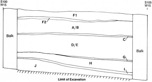
The most remarkable aspect of unit S105/W20 was its column of soil strata. Inspection of the east unit profile showed that each layer slopes downward gently toward the lakeshore and consists of well-sorted sands and gravels (Figure 7). The north profile, on the other hand, exhibits essentially level bedding of the soil layers. The configuration and content of those deposits, therefore, both point toward the conclusion that the column represents a natural beach sequence built up over the course of time.
|
|
A Brown Sandy Loam with Small Particles of Yellowish Brown Coarse Sand B Yellowish Brown Coarse Sand C Thin Lens of Black Sand D Brown Loamy Sand with Large Patches of Yellowish Brown Sand and Sparse Pea Gravels E Homogeneous Brown Loamy Sand F Homogeneous Yellowish Brown Coarse Sand with Streaks of Gray Sand F1 - Overburden, Clay Silt F2 - Overburden, Red Clay and Pea Gravel G Thin Layer of Fine Gravels H Homogeneous Yellowish Brown Coarse Sand I Pea Gravels and Black (Iron-Rich) Sand J Homogeneous Yellowish Brown Coarse Sand Figure 7. East Profile, Test Unit S105/W20. |
It is interesting to note that most of the artifacts derived from deposits nearly a foot below the present ground surface. Further, those materials were primarily of late nineteenth-century origins; few items representing the fur trade era appeared at this location. Those facts suggest that the lakeshore area probably has been subject to successive stages of scouring and aggrading, which may have removed evidence of early occupations while deeply burying items that are relatively late in Grand Portage's history. This is not to say, however, that such dynamics have been exclusively natural. The uppermost deposits, for example, may be the result of purposeful ground leveling action. Nevertheless, most of the soil column is without a doubt the product of natural beach development.
Great Hall/Kitchen Area
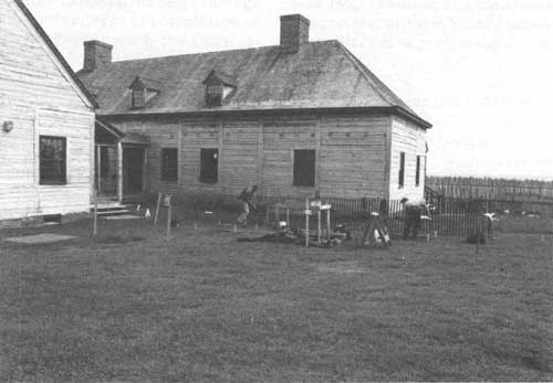
The 1989 investigations within the Depot at Grand Portage included the excavation of two test units between the reconstructed Great Hall and Kitchen on a rather level bench that may represent an old beach ridge. It was in this area that a section of drain conduit would be run west from the Kitchen before turning south toward the lake. Since no previous investigations had been carried out in that particular area, the two 5 ft x 5 ft units sought to determine whether any significant archeological deposits might lie in the proposed path (Figure 8).
|
| Figure 8. Excavations begin at the Kitchen/Great Hall Area. |
Unit N60/E10 was situated near the drain's probable turning point, a short distance from the Great Hall's northwest corner. The other unit, N60/E30, was 20 ft farther east, approximately half way to the Kitchen structure. Location of the latter test unit was dictated, in part, by a desire to expose a utility line believed to be buried in the general area.
Neither of the units yielded any remarkable information. Both exhibited a layer of recent fill in their uppermost reaches, no doubt deriving from activities related to reconstruction of the two buildings. Beneath the fill, the units were littered with numerous large glacial cobbles that appeared to have lain unmolested since their original deposition during the last Ice Age. A dense clay zone also occurred in both units at an approximate depth of 3 ft below the ground surface.
Artifacts yielded by these two test units were unremarkable. They represent practically the entire range of historic occupation at Grand Portage, from the fur trade era through its development as a public park. Further, since they were not associated with any discrete cultural feature, those materials have limited utility toward drawing archeological interpretations.
The only information of great importance gleaned from the Great Hall/Kitchen area concerned the location of an active utility line. Although the Monument maintenance files contained a schematic map of the buried telephone line, it was not felt that the drawing was accurate enough to ensure avoidance of the line during trenching. Excavations in N60/E30 exposed the active line approximately 1 ft below the ground surface. Another line that had been abandoned in place also was discovered. The locations of both were marked on the surface for later reference.
| <<< Previous | <<< Contents>>> | Next >>> |
noble-90/sec2.htm
Last Updated: 15-Jul-2009