|
GRAND PORTAGE
An Archeological Survey of Development Projects Within Grand Portage National Monument, Cook County, Minnesota |

|
Chapter 5
CURRENT RESEARCH
FIELD METHODS
Methods employed in the 1988 field investigations within Grand Portage National Monument varied according to the dictates of each proposed development project. In most cases, the survey team used a systematic shovel testing protocol to examine land parcels for archeological materials. In some cases, however, the investigators used less structured procedures, and in one instance monitoring of ground disturbing activities served in place of a preconstruction examination of the project area.
Since most of the proposed development areas are covered in vegetation, the standard procedure for archeological survey of a land parcel entailed close-interval shovel testing in a systematic fashion. The three members of the survey team paced across each alternate construction area in transects separated by 10 m. Along each transect the team members excavated a small shovel test (at least 30 cm in diameter and 50 cm deep) at 10 m intervals. Soil profiles were observed and recorded, and the excavated soils were examined for archeological materials. Collections taken from shovel test proveniences were bagged according to a coordinate system representing the transect and test interval. Thus, "ST 1-4" would indicate the fourth shovel test excavated along the first transect line in a study area.
This general procedure was continued back and forth across each major land parcel until the entire study area had been examined. Some parts of each parcel could not be shovel tested, owing to logistical difficulties (marshes, existing developments, etc.). Nevertheless, coverage of the various study areas was adequate for determining the presence or absence of cultural resources.
In smaller areas, such as the narrow corridor selected for burial of a canoe warehouse security system, random shovel tests were sufficient for purposes of probing the soil deposits. Inspection of the parking lot gate development, on the other hand, was accomplished simply by observing installation of the gate posts.
When an archeological site was discovered on a parcel, as in the case of Maintenance Alternate #1, more detailed investigation continued. Through the use of 1-m-by-1-m test units excavated in arbitrary 10-cm levels, a larger sample of artifacts could be collected and the depositional context evaluated. In that way, the excavators gathered additional information relating to site type, age, complexity, and integrity.
The archeological team documented all controlled excavations through the use of plan and profile drawings, as well as photographic images. Pertinent records generated during all phases of the 1988 investigations at Grand Portage National Monument are on file at the Midwest Archeological Center in Lincoln, Nebraska.
RESULTS OF THE SURVEY
Descriptions of the areas surveyed within Grand Portage National Monument are offered below, according to the specific development project necessitating investigations. The findings of each survey are summarized along with comment on their significance to planners.
Facility Parcels
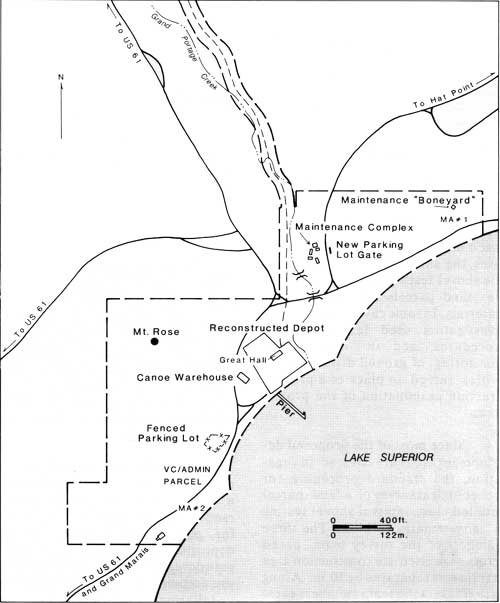
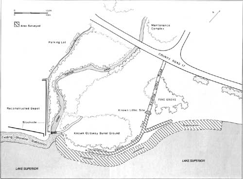
As stated previously, the construction of a visitor center with administrative offices is proposed for the Monument. In addition, a separate maintenance facility is planned. At the time this survey began, three land parcels had been identified as possible construction sites (Figure 4). The largest parcel, located at the southwestern edge of the Monument property on the west (landward) side of County Road 17, is proposed for the visitor/administration building. Two other parcels represent alternative locations for the maintenance facility. Alternate #1 is located at the extreme northeastern edge of the Monument property, where a National Park Service maintenance storage area (or "boneyard") is currently located. Alternate #2 lies directly across the asphalt road from the proposed visitor/administration parcel, along the lakefront.
|
| Figure 4. Study area locations. |
The visitor/administration facility plans provide for construction of the building itself, as well as a parking lot and access roads. When the archeological team arrived at the land parcel, it was found that the vehicular areas had been staked and flagged. Lacking copies of the preliminary construction drawings, those markers helped orient the team within the heavily wooded parcel.
Systematic shovel testing, which followed the standard routine previously outlined, yielded no evidence of cultural resources beneath the vegetation cover. Survey of the parcel, however, did result in the observation of several refuse dumps exposed on the ground surface. Most of the dumps were relatively recent in age, judging from the materials they contained. The Grand Portage Chief of Maintenance remarked that at one time a house had stood in this general vicinity. Further, he believed that it had been there since at least the 1930s and was removed shortly after the park was established. Therefore, it is likely that much of the refuse derives from that rather recently abandoned occupation.
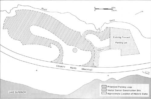
One refuse pile, however, was quite extensive and included artifacts dating roughly from the turn of the last century. Among the materials observed were numerous glass bottles made from a three-piece mold, indicating pre-1903 manufacture. The deposit, which was left undisturbed, may have significance for understanding late nineteenth- and early twentieth-century activities in this region. Fortunately, it seemed to lie well outside what appears to be the marked centerline of the access loop (Figure 5). If that is the case, it may be easily avoided during construction.
|
| Figure 5. Location of dump site within proposed visitor center/administration facility parcel. |
It should be noted that no evidence of a former structure could be seen in the course of surveying this parcel. It is quite possible, however, that demolition of the structure was so complete that no remains survive. It may also be that an existing fenced parking lot at the northern end of the proposed construction site was built atop the house site. The gravel surface within that enclosure prevented any exploration of the parking area.
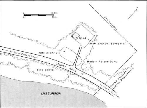
The parcel identified as Maintenance Alternate #1 for purposes of this report surrounds the existing maintenance "boneyard" located at the eastern limits of the Monument (Figure 4). This area contains a low relict beach ridge of Lake Superior that is bordered to the east and north by marshy lowlands. Over 20 years ago archeological surveys were conducted in this general area by Stoltman and Woolworth, but those earlier efforts did not examine the entire parcel now proposed as a possible construction site (Woolworth and Woolworth 1982:230-235). Therefore, continued investigation was in order.
A large surface dump is present in a marshy thicket near the eastern Monument boundary. Observable refuse, mostly cans and bottles, seems to date from relatively recent times. Therefore, the dump is not considered to be of any consequence. Systematic shovel testing across the ridge, however, revealed good evidence of what appears to be a previously unrecorded early Historic period archeological site (Figure 6), which is described more fully in Appendix A of this report.
|
| Figure 6. Location of Maintenance Alternate #1 site. |
In the grass covered clearing between the "boneyard" enclosure and the gravel lakefront road several shovel tests yielded probable late eighteenth- or early nineteenth-century materials (see Appendix B). Numerous seed beads used for embroidery, gunspall fragments, and wrought nails were among the artifacts collected from the site. In addition, a small silver cross with bulbar arms was recovered. Such items are typical of sites associated with the fur trade in North America, and the site is no doubt contemporary with the post at Grand Portage. It could not be determined, however, if the site, which lies approximately 400m (1200 ft) east of Grand Portage Creek and 100 m (300 ft) north of Lake Superior, represents a European or a historic Indian occupation.
Continued shovel testing of the old beach ridge suggested that the archeological site is approximately 600 square meters in area, measuring 40 m on its east-west axis and 15 m from south to north. The subsequent excavation of two 1-m-by-1-m test units showed no evidence of stratified archeological deposits. Natural strata do occur, but there does not seem to be any direct correlation of those deposits with the types of cultural materials they contain. Early Historic period materials appear to be present throughout the soil column, though modern debris is limited to the upper levels. It should also be noted that two cultural features were partially exposed and excavated. One is certainly recent, but the other possibly could date from the early Historic period.
Although it was not within the scope of this survey to evaluate any discovered archeological sites fully, site integrity appears to be good. Some degree of disturbance is evident, however, in the form of more modern debris. For example, large amounts of wire nails and automobile safety glass are present in the upper soil deposits, especially at the site peripheries. Those materials, which are mixed with apparent early Historic materials, are not surprising in view of the fact that early twentieth-century maps of the area show many reservation structures in this general vicinity. In fact, a few nearby residences remained occupied until the late 1960s. There is no indication, however, that construction of the existing maintenance "boneyard" did any significant damage to the archeological site. A gravel driveway seems to bisect the site, but has probably served to seal undisturbed archeological deposits below it.
The Maintenance Alternate #1 site has been designated Site 21CK12 by the Office of the State Archaeologist for Minnesota. As stated above, the purpose of the 1988 survey was limited to making an inventory of cultural resources that might be present in the various development areas; it was not designed to assess the significance of sites so discovered in terms of eligibility for the National Register of Historic Places. Therefore, if there is any danger that the site might be disturbed by construction activities, further investigation will probably be in order.
It should be noted, however, that our preliminary study of the site indicates that it is rather small in size and appears to be entirely confined to the open field in front of the maintenance "boneyard." Therefore, it is possible that a new facility could be built within the parcel without impacting the archeological site. Should this alternate be chosen for construction, closer scrutiny will be required to determine whether the archeological site can be avoided.
The other parcel under consideration for construction of a maintenance facility is located directly across the access road from the proposed visitor/administration parcel (Figure 2). Maintenance Alternate #2 is a narrow strip of land between the black top road and Lake Superior. The level ground surface is perched approximately 2-3 m above the lake's water line. Unlike Maintenance Alternate #1, this parcel is thickly wooded.
Systematic shovel testing and observation of the ground surface produced no evidence of the presence of any cultural resources on the parcel. Only a few isolated items of surface trash were noted, and those all seemed to lie within the "toss zone" of the nearby county road. Accordingly, there is no archeological basis for this alternate to be excluded from consideration as a possible construction site.
Lakeshore Stabilization
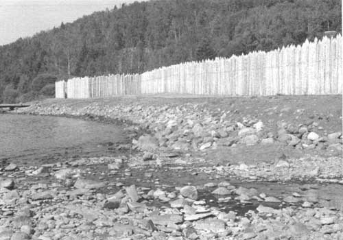
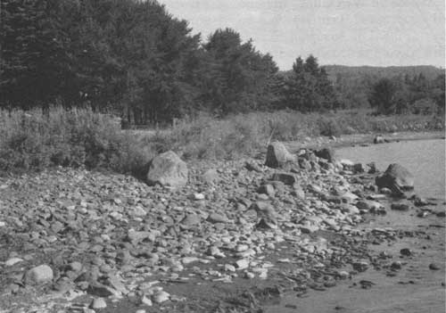
The second major development project that was investigated during the 1988 archeological survey is the proposed continuation of lakeshore stabilization within the Monument. Previously, a section of lakeshore immediately in front of the reconstructed stockade had been stabilized with rip-rap (Figure 7). In addition, the banks of nearby Grand Portage Creek had received similar treatment (Monk 1986).
|
| Figure 7. Stabilized shoreline on lake (south) side of reconstructed depot (facing west). |
The currently proposed stabilization project covers a section of Lake Superior shoreline running east from the mouth of Grand Portage Creek (Figure 8) for a distance of approximately 215 m (700 ft). In order to facilitate placement of large boulders that will serve to reduce bank erosion in this area, this development will require the establishment of temporary haul roads along the top of the bank (Figures 4 and 9).
|
| Figure 8. Lake Superior shoreline scheduled for stabilization (facing east). |
|
| Figure 9. Proposed lakeshore stabilization area. |
It was known through previous archeological research within the Monument, that the area east of Grand Portage Creek was used extensively during the early Historic period (Woolworth and Woolworth 1982). Immediately adjacent to the creek are the presumed locations of a historic Ojibway burial ground and a voyageurs' campground. Both of those sites, however, are believed to lie at a distance back from the edge of the lakeshore bank. A small lithic site is also known to lie near the southern end of the Grand Portage, where a picnic grove is now located. In addition, several structures formerly used by the Bureau of Indian Affairs once stood in this general vicinity. Therefore, the 1988 archeological survey sought to determine whether any unknown cultural resources might be present within the zone of potential construction impacts.
Along the entire length of the shoreline scheduled for stabilization, the archeological team visually inspected the eroding bank face. Those efforts, however, revealed no indication of a buried soil horizon or cultural features. Nor were any artifacts observed eroding out of the cut bank.
Attention then shifted to the ground surface on top of the embankment. Shovel tests excavated at regular intervals within a 10 m corridor along the bank edge yielded no evidence that would suggest an archeological site of any consequence. Some Historic period materials were observed in shovel tests near the grassy picnic area, approximately at the terminus of the Grand Portage. The materials were in low density, however, and seemed to represent relatively recent deposition.
Despite the fact that no potentially significant cultural resources seem to be present within the direct impact zone of the project area, several historic and prehistoric sites are known to be located in close proximity. Therefore, extreme caution must be exercised when the rip-rap is laid along the shoreline. Grading and other earth-moving activities should be kept to the absolute minimum.
Canoe Warehouse Security Line
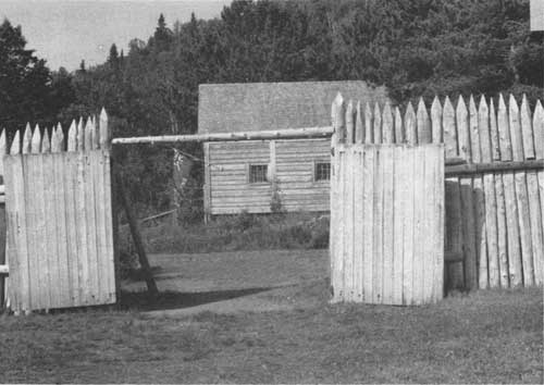
A minor development project investigated during the 1988 survey relates to the proposed burial of a utility line connecting the post's reconstructed Great Hall and a canoe warehouse located outside the west stockade curtain (Figures 4 and 10). That line, which constitutes part of a new security system for the canoe warehouse, will run a distance of approximately 75 m (250 ft). More than half the distance, however, will lie within the reconstructed stockade, where an active utility trench already exists. Since plans call for burial of the new line within that existing trench, only the area between the stockade line and the canoe warehouse required examination. That length of new ground disturbance is approximately 30 m (100 ft).
|
| Figure 10. Reconstructed canoe warehouse viewed through west palisade gate. |
The archeological team excavated several random shovel tests within the clearing where the line is proposed. No cultural materials were present, and it appeared that the grounds had already been greatly disturbed. The first 20 cm (8 in) below ground surface are composed of a dense slatey fill, which is doubtless the result of modern deposition. Subsequent examination of an aerial photograph, apparently taken in the early 1960s, shows that the ground surface in this area was at that time churned and rutted by the movement of heavy machinery (perhaps during construction of the nearby toilet facilities). It seems likely that the fill noted in 1988 derives from that earlier development episode.
In view of the fact that the fill zone in this area is deep, and burial of the utility line will be immediately below the ground surface, this development should have no adverse effect on any cultural resources. If plans change, however, to include trenching at a greater depth or along a different route, the Regional Archeologist should be so advised. It can then be determined if additional reconnaissance will be necessary.
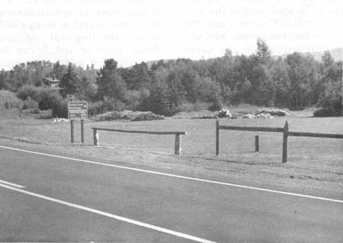
Parking Lot Gate
The last development project to be considered involved the least amount of ground disturbance and was the first investigated during the 1988 survey at Grand Portage. The project entailed installation of two wooden gate posts for an overflow parking lot off County Road 17 directly north of the reconstructed stockade and east of the Monument maintenance complex (Figures 4 and 11). Since this only required augering two post holes, which would not be much larger than standard shovel tests, monitoring of the activity was sufficient for our purposes.
|
| Figure 11. Overflow parking lot, showing new gate. |
The soil profiles exposed in both auger holes were examined for any indication of cultural deposits, but no such evidence could be observed. In fact, it appeared that fill had been deposited in the upper reaches of the soil column, probably during construction of the adjacent roadway. Furthermore, examination of the soils removed by the auger yielded no artifacts whatsoever. The negative evidence derived from this location, however, does not preclude the possibility that archeological remains maybe present in the immediate vicinity. Indeed, given the proximity of the trading post, it is likely that this area saw frequent use during the early Historic period. Therefore, should other developments be contemplated at or near this location, additional archeological review will be required.
| <<< Previous | <<< Contents>>> | Next >>> |
noble-89/chap5.htm
Last Updated: 15-Jul-2009