|
GRAND PORTAGE
An Archeological Survey of Development Projects Within Grand Portage National Monument, Cook County, Minnesota |

|
Appendix A
MAINTENANCE ALTERNATE #1 SITE
This appendix constitutes a formal description of the Maintenance Alternate #1 site, henceforth referred to as MA1. The site, which was discovered during the 1988 archeological survey of Grand Portage National Monument, has been designated Site 21CK12 by the Minnesota State Archaeologist's Office. Complete artifact inventories from the site are presented in Appendix B of this report.
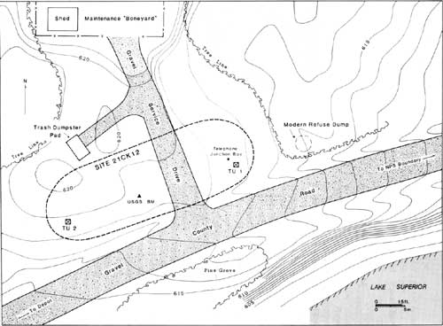
MA1 is located in the NE 1/4, NE 1/4, SW 1/4, SE 1/4 of Section 4, Township 63N, Range 6E. The site lies in the extreme northeast sector of Grand Portage National Monument, approximately 50 m west of the eastern boundary line and 300 m east of Grand Portage Creek. It is situated between a gravel county road, which parallels the lakeshore, and an existing maintenance storage facility (or "boneyard") employed by the Monument staff (Figures 4, 6, and 12).
|
| Figure 12. Detail of Maintenance Area #1 site. |
The area in which the site is located is composed of glacial lakebed deposits, and the site itself lies atop a relict beach ridge approximately 40 m north of the present shoreline. The ridge forms a low prominence, bordered to the north and east by marshy lowlands. Its elevation is between 188.4 m (618 ft) and 189 m (620 ft) amsl, or approximately 4.9-5.5 m (16-18 ft) above the current level of Lake Superior. The ridge appears to be well drained and today is covered with grasses and a few saplings.
It was obvious immediately that the former beach ridge had been disturbed to some extent in relatively recent times. Foremost, of course, was the "boneyard" enclosure, which is surfaced with a bed of gravel. Further, the maintenance yard appears to sit on thick fill at the northern edge of the ridge. In front of the 24-m-wide enclosure, a narrow drive connects the gateway with the lakefront road, and a small trash dumpster on a concrete pad is west of the driveway. It was also apparent that buried telephone lines are present in the ridge. A junction box of sorts stands above ground approximately 7 m east of the gravel drive way and 8.5 m north of the lakefront road.
It was also known from documents and previous archeological research that several residential structures had stood in this general vicinity as late as the 1960s; the nearest of those former structures, the La Plante residence, was occupied until 1967. No surface evidence of the houses or their associated outbuildings appears to survive, though it seemed probable that subsurface deposits from those occupations would still be present. Upon further investigation of the ridge, that proved to be the case.
PREVIOUS RESEARCH IN THE AREA
According to Woolworth and Woolworth (1982:230-235), the extreme northeastern sector of Grand Portage National Monument was previously investigated in 1961 and 1962. In late August of 1961, James Stoltman directed the excavation of seven test trenches in this vicinity. Stoltman's work centered on an "elevated knoll near the northeast monument boundary," which is identified as an "earlier beach stage of Lake Superior" (Woolworth and Woolworth 1982:231). Subsequently, Alan R. Woolworth continued investigations in September of that same year. He was responsible for the excavation of a series of parallel test trenches near the La Plante residence, which was then still occupied. The structure, as well as several others in the area, was removed later in that decade.
In Woolworth's estimation, "nothing of any significance was found" near the La Plante residence (Woolworth and Woolworth 1982:232). He attributes the general artifact assemblage to the turn of the century (1890-1910), but without adequate description of the materials it is difficult to know on what basis. Some of the artifact types (beads, clay pipes, etc.) conceivably could represent earlier occupations. It is also possible that earlier deposits were missed, owing to the fact that some areas of the sector were not tested in deference to residents who still occupied the property.
Other archeological surveys have been conducted in this general area in recent years. The most recent was Lynott's (1988) inspection of a proposed road alignment a few months before the investigations reported here.
THE 1988 SURVEY AND TESTING
Systematic shovel testing of the Maintenance Alternate #1 land parcel revealed an apparent late eighteenth- or early nineteenth-century occupation roughly centered on the relict beach ridge that occurs here. The MA1 site appears to have area of about 600 sq m. Along its east-west axis, the site measures approximately 40 m, whereas the north-south dimension is approximately 15 m. Archeological materials do occur outside of those limits; however, they represent a later occupation of the parcel dating from this century.
It should be acknowledged that many of the artifacts identified as representing the early Historic period, derived both from shovel tests and excavation units, possibly could be later in age. Many bead varieties, for example, continued to see use in the area long after the close of the fur trade, and other objects are too fragmentary to be absolutely certain of their period of manufacture. Nevertheless, the frequent occurrence of gunspalls and wrought iron nails, as well as a single trade cross, tends to argue for a component at the site that is roughly contemporary with the post at Grand Portage.
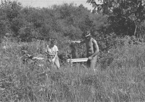
Two 1-m-by-1-m test units were excavated within the site limits established through systematic shovel testing (Figure 13). Test Unit 1 was located between the "boneyard" driveway and the eastern edge of the site, whereas Test Unit 2 was placed close to the western site limit. Both units produced a mixture of early Historic and modern artifacts, with the latter generally concentrated in the upper levels. Both also suggested the presence of archeological features but none that definitely dated to the early Historic period.
|
| Figure 13. Testing at Maintenance Area #1 site (facing northeast). |
Test Unit 1
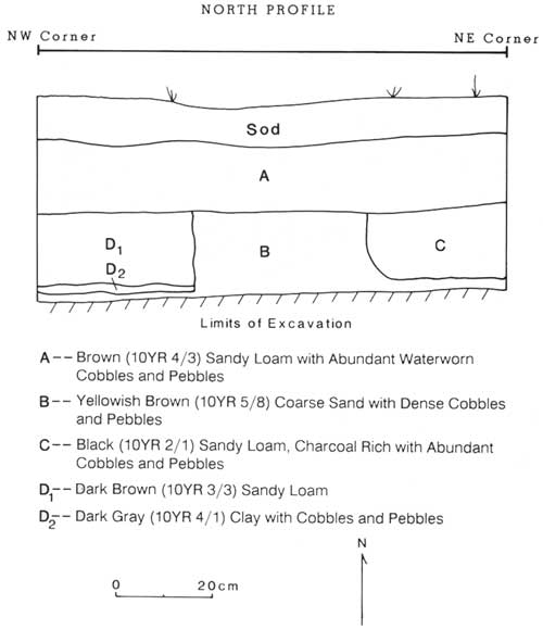
Test Unit 1 (Figure 14), when examined in profile, shows that the site is topped by a layer of sod approximately 10 cm thick. This zone is developed in a soil that contains abundant waterworn cobbles and pebbles. Most of the materials recovered from the sod zone were twentieth-century artifacts, particularly safety glass from an automobile window. Only a few probable late eighteenth-century items, such as wrought nails and a cuprous kettle rim, were present at this level.
|
|
A -- Brown (10YR 4/3) Sandy Loam with Abundant Waterworn Cobbles and Pebbles B -- Yellowish Brown (10YR 5/8) Coarse Sand with Dense Cobbles and Pebbles C -- Black (10YR 2/1) Sandy Loam, Charcoal Rich with Abundant Cobbles and Pebbles D1 -- Dark Brown (10YR 3/3) Sandy Loam D2 -- Dark Gray (10YR 4/1) Clay with Cobbles and Pebbles Figure 14. North profile, Test Unit 1. |
Beneath the sod zone is a layer 14 cm thick of brown sandy loam, again littered with beach cobbles and pebbles. Early Historic period materials are more frequent at this level, though still in low proportion relative to more recent debris. Here, as elsewhere at the site, small seed beads and gunflint chips are present. Furthermore, both artifact types show discoloration typically the result of having been exposed to fire.
It was noted that almost all of the artifacts at this level of Test Unit 1 derived from the western third of the unit. In plan view, it appeared that soils in that part of the square were somewhat darker than the remaining excavation floor. As excavation continued, a culturally sterile subsoil made up of yellowish brown coarse sand helped define the limits of a linear feature in the western third of the unit. That zone of black sandy loam ran along the entire west wall of the unit, its eastern edge forming a straight line approximately 30 cm from the west profile. That line showed up clearly in the unit's north profile wall (Figure 14).
The bottom of the feature, which was found at approximately 40 cm below surface (cmbs) proved to be essentially flat. Further, it seemed to be purposefully lined with a thin lens of gray clay. The function of this feature is unknown, as is its full size. The mixture of early and more modern materials, however, indicates that the feature was a recent intrusion into the site that incorporated materials already present when filled.
A second, smaller feature was evident in the northeast corner of the test unit. When viewed in plan, the black loamy sand deposit formed a rough rectangle. Its western edge met the north profile at 30 cm from the northeast corner stake, whereas the feature extended 20 cm to the south along the east profile wall. The deposit contained a heavy concentration of charcoal, but no artifacts whatsoever were recovered from its fill. Therefore, it is not possible to infer the age of this feature for lack of temporally-diagnostic materials. It is interesting to note, however, that the depth of this deposit corresponds closely to that of the feature that is certainly modern.
Test Unit 2
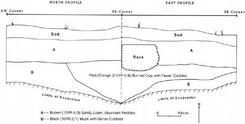
Test Unit 2 (Figure 15) exhibits a sod layer similar to that evident in Test Unit 1. As in the other unit, this upper 10 cm of soil contained a mixture of late eighteenth- and twentieth-century artifacts, with the latter forming the bulk of the assemblage. In addition, some materials (e.g., ceramics) found at this level and lower in the unit seem to represent the latter part of the nineteenth century.
|
| Figure 15. North and east profiles, Test Unit 2. |
Again in Test Unit 2, the sod zone lies atop a layer of brown sandy loam that probably developed through leaching of organic materials. The layer forms a horizontal bed, extending slightly more than 30 cmbs. Two arbitrary 10-cm levels were excavated in this deposit yielding a wide range of eighteenth- through twentieth-century artifacts. Seed beads were recovered in large numbers (more than 900 in two levels combined), with most of them concentrated in the northeast corner of the unit.
Continued excavation revealed an area of reddish orange burned clay in that corner; by Level 4 (30-40 cmbs), the rest of the unit floor was a culturally sterile deposit of black muck. In plan view at 40 cmbs, the feature met the north wall of the unit approximately 40 cm from the northeast corner stage; the fill edge ran at an angle to the southeast, intersecting the unit's southeast corner. Large pieces of burned wood were present in this clay fill along with numerous seed beads and other eighteenth-century artifacts. When viewed in profile, it is clear that the visible part of this feature is somewhat basin shaped, with its deepest point at the unit's northeast corner approximately 70 cmbs. Although its function cannot be determined, it appears that the feature is cultural, and despite the occurrence of some recent materials in the fill, it is probable that the feature dates from the early Historic period.
Synthesis
The two test units, in combination with a number of shovel tests systematically excavated across the relict beach ridge, demonstrate that a potentially significant early Historic archeological deposit is present in the land parcel identified as Maintenance Alternate #1. Although the site is small and unstratified, it possesses large numbers of late eighteenth- or early nineteenth-century materials and may include intact cultural features. Despite some obvious areas of disturbance, the site also appears to exhibit a surprising amount of integrity. This is particularly remarkable in view of the fact that the general site area was occupied until the 1960s, and it still is used by GRPO maintenance personnel.
Raw frequencies of artifacts recovered from the beach ridge (see Appendix B) tend to misrepresent the amount of disturbance that has occurred at the MA1 site. Actual artifacts total 3,216, of which 1,606 are almost definitely from the early Historic period. At face value, those figures would suggest that slightly more than half the artifacts recovered in our limited investigations are recent debris. However, if one considers that some 1,423 pieces of clear glass appear to derive from a single broken automobile windshield, the relative proportions change dramatically. Artifact totals excluding those sherds indicate that 1,606 items out of 1,793 (or nearly 90%) represent the early Historic period. In those terms, it appears that the degree of modern site disturbance has been rather minimal.
Accordingly, the Maintenance Alternate #1 site (21CK12) must be considered a potentially significant cultural resource. Testing sufficient to assess the site's possible eligibility to the National Register of Historic Places was not undertaken in 1988, since such investigations would have been beyond the project scope-of-work. Should the area in question be selected for construction of the new maintenance facility, further excavation and evaluation of the site may be necessary.
| <<< Previous | <<< Contents>>> | Next >>> |
noble-89/appa.htm
Last Updated: 15-Jul-2009