![]()

Cover Page
MENU
![]() War Between the States
War Between the States
|
Glimpses of Historical Areas East of the Mississippi River |
|
The War Between the States |
|
TENNESSEE |
Special Features: Great Civil War battlefield; finely preserved Indian mounds.
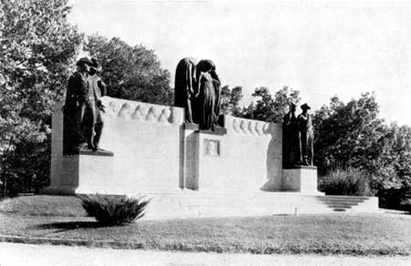
Confederate Memorial, Shiloh National Military Park.
(Photo by Rinehart)
THE NATIONAL MILITARY PARK at Shiloh, Tenn., established in 1894, is slightly more than 5-1/2 square miles in extent. Its boundaries include the region of the heaviest fighting in the battle of Shiloh, or Pittsburg Landing, April 6 and 7, 1862, which up to that time was the greatest battle which had been fought in the War between the States. The park, together with the historic highway, 17 miles long, connecting it with Corinth, Miss., constitutes an area which was vitally important in the military operations in the West.
Following the fall of Forts Henry and Donelson, the Confederates under Gen. Albert Sidney Johnston formed a new line of defense extending from Memphis along the railroad to Chattanooga, and concentrated about 44,000 troops at Corinth. Meanwhile Grant had moved up the Tennessee River for the purpose of breaking up this line and had taken up a position at Pittsburg Landing with an army of some 40,000 men. Grant planned to attack Corinth as soon as he had been joined by Buell's army of 18,000 men from Nashville. However, Johnston took the initiative and himself attacked Grant before Buell's arrival.
On Sunday, April 6, shortly after daybreak, the Confederate line of battle struck the outlying Federal camps, and a ferocious struggle raged until evening among the dense woodlands, across the small farm clearings, and in the depths of the swampy ravines which characterize the region. The heaviest fighting of the morning occurred around Shiloh Church, a little log structure, which was tenaciously held by the Federal right because it stood near the intersection of a number of important roads. After repulsing several determined assaults the Federals had to abandon Shiloh Church at about 10 a. m.
Johnston now undertook to drive his right like a wedge between the river and Grant's left flank, cutting off the Federals from their base at Pittsburg Landing. At Peach Orchard and at the Hornets' Nest, where an old sunken road was stubbornly defended by the Blue infantry, he encountered desperate opposition, and the fighting was furious for hours. It was near Peach Orchard that General Johnston was struck in the right leg by a Minie ball which severed an artery and caused his death at about 2:30 o'clock that afternoon. The giant oaks under which he died still stand as living memorials to this distinguished southern leader.
Close to this spot is Bloody Pond, the water of which was dyed crimson with the blood of wounded and dying men who crawled to it to slake their torturing thirst. Not far from Bloody Pond is a bullet-scarred log cabin, the only remaining one of several which stood at the time of the battle.
In the Hornets' Nest occurred the highest percentage of casualties suffered during the battle. There remnants of three Federal divisions were hemmed in and, though repulsing with fearful slaughter 12 Confederate charges, were compelled to surrender shortly after 5 p. m., more than 2,200 men becoming prisoners.
Driven 2 miles since morning, the battered Federal line by sunset stood with its back to Pittsburg Landing. But as it was beaten into the angle between Owl Creek and the Tennessee River, its fearful losses were partly offset by the progressive narrowing of its front, from 3 miles at 10 a. m. to less than half that distance at evening. There, stiffly supported by a heavy line of artillery and protected in front by the enfilade fire of the Federal gunboats in the river, the sorely tried remains of Grant's army repelled the last desperate charges of the Confederates.
During the night the arriving divisions of Buell's army poured more than 20,000 men across the river on the transports, and by the morning of April 7 about 54,600 troops confronted the 34,000 weary Confederates remaining in ranks under Beauregard, who had succeeded Johnston. Renewing the battle under such circumstances, Beauregard soon found himself losing ground. His men yielded only step by step, fighting stubbornly, and it was after 2 p. m., when he reached the vicinity of Shiloh Church, that he finally gave orders for his troops to retire to Corinth, which they did in good order and unpursued. The price of victory to the Federals was 13,047 killed, wounded, and missing. The Confederate loss was nearly 11,000.
Immediately after the battle Grant ordered the burial of the dead of both sides in trenches on the field. Four years later the remains of the Federal dead were removed to the present national cemetery situated on the bluff above the landing. Only about one-third of the 3,649 graves contain identified remains.
Among the striking features of this cemetery are the pyramid of cannon on the site of General Grant's headquarters, the markers in the officers' circle, and those indicating the graves of Capt. Edward Saxe, Henry Burke, the 13-year-old drummer boy, and the six color sergeants.
The Confederate dead still are interred in five trenches scattered over the field. Each trench is surrounded by a concrete enclosure studded at intervals with cannon balls. The largest of these trenches is estimated to contain the remains of approximately 600 soldiers.
There is abundant evidence in the park of the activities of the mound-building Indians. In a group on a wooded bluff overlooking the Tennessee River, three-quarters of a mile south of the park headquarters, stand seven large mounds, six of which are fiat-topped platform mounds, 5 to 15 feet in height, while one is an oval-shaped burial mound. Early in 1934 extensive archeological excavations were carried on there as a Federal C. W. A. project under the direction of the Smithsonian Institution. More than a score of graves were uncovered, as well as quantities of bone implements, stone axes, and projectile points, clay pipes, clam shells, quantities of broken pottery, much of it decorated, and other objects.
This park retains a large part of its wilderness character. The majestic Tennessee, unusually broad at this point, defines the eastern boundary of the park. From the crest of a 100-foot forest-clad bluff near Pittsburg Landing, the visitor may obtain a magnificent panoramic view of the surrounding country. From this point attractive trails wind down to the landing and to the mouth of Dill Branch near the Indian mounds.
An interesting collection of relics, manuscripts, maps, and charts is on display in the Administration Building. Here also lectures are given by members of the historical staff.
The new concrete highway to Corinth follows the original Corinth Road over which the Confederates advanced on Shiloh. Along this road traces still exist of the old battery position and earthworks thrown up by the contending forces.
NEXT> Stones River National Military Park
 Top
Top
Last Modified: Thurs, Nov 23 2000 10:00:00 pm PDT
http://www.cr.nps.gov/history/online_books/glimpses3/glimpses4d.htm
![]()