|
GLACIER
Some Lakes of Glacier National Park |

|
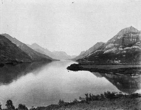
WATERTON LAKE.
Waterton Lake is at the northern end of the park, half in the United States and half in Canada. This lake has been given different names. On the first maps of the district it is called Chief Mountain Lake; on some of the later maps it is called Kootenai Lake, which is also the name given by some of the residents.
This lake is easily approachable by road from the Canadian end. From Lake McDonald it is reached by trail, the distance being about 33 miles. It is 10 or 12 miles long and has an average width of perhaps half a mile. Its altitude is 4,166 feet. Soundings were made on this lake on August 17, 1910. The temperature of the water at 1.30 p. m. was found to be 56° F., while the temperature of the air at the same time was 62.5° F. Sounding was made 200 feet east of the rocky ledge on the west shore, about 2 miles from the upper end.
The depth was 210 feet. Another sounding, made approximately the same distance from the upper end and about halfway across, gave a depth of 317 feet. These were the only two soundings made on this lake. The temperature of the water at 8.30 p. m. of August 9, 1911, was 52° F., the air temperature being then 47° F.
|
| GENERAL VIEW OF THE LAKES AND MOUNTAINS, WATERTON LAKE. NORTHERN END OF UPPER LAKE, WHICH IS CROSSED BY THE BOUNDARY. |
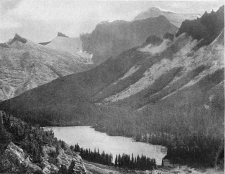
LAKE ON OLSON CREEK.
Most of the water from Waterton Lake is received from Little Kootenai Creek. Just before this creek enters the lake it receives the waters of Olson Creek, which comes in from the west. The trail leads up this creek and over Brown Pass to the lakes and streams of the western slope, which drain into the Flathead River. The trail by Olson Creek and over Brown Pass traverses one of the picturesque portions of the park, and will doubtless be visited by many tourists. This will be especially true of those coming in from the Canadian side. On Olson Creek, 3-1/2 miles above Waterton Lake, is a small lake that is unnamed. It is in a beautiful location, in the very heart of magnificent mountains. The altitude is about 5,000 feet. The shore is open and easily accessible.
This lake is fed by streams, heading in the snowbanks of near-by mountains. It is without fish. On Olson Creek, between this lake and Waterton Lake, are numerous falls, up which fish are not able to ascend. The lake is not deep, being only 5 feet at the upper end and 10 feet at the lower. It is situated in a mountain pocket, and has been made by a mass of glacier bowlders. This mass extends for a mile or more down the creek, forming a series of falls and cascades, over which the water dashes with great noise.
|
| LAKE ON OLSON CREEK, FROM THE MOUNTAIN SIDE, LOOKING TOWARD MOUNT CLEVELAND, WHICH IS ON THE RIGHT IN THE DISTANCE. |
The temperature of this lake at 5 p. m. on August 11, 1911, was 52° F. in the center and 54° F. near the shore. The air temperature at the same time was 59° F. This and other temperatures here given were taken about 6 inches below the surface.
From observations made by the use of the surface net and the dredge and from the character of the shore line it would seem apparent that fish could do well in this lake. While it may freeze over, and doubtless does freeze over in winter, it would surely not freeze to the bottom, and fish should live during the winter as in any other lake.
There is in it a considerable abundance and variety of microscopic life. One species of water snail is found in considerable abundance. The larvae of numbers of insects were abundant. The streams which supply the water doubtless carry into it considerable quantities of insect life.
As the northern shore of the lake is open, it is a favorite camping site. Should the lake be stocked with fish it would make the region doubly interesting to tourists. Furthermore, the fish could easily ascend the streams to a distance of several miles.
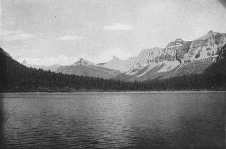
LAKE SOUTHEAST OF BROWN PASS.
On Olson Creek. about 2 miles above the lake last described, is another unnamed lake.
This lake is some 5 or 6 miles from Waterton Lake, and lies at the foot of tremendous cliffs, in a charming spot, close to the trail. Its altitude is about 5,250 feet. It is fed by two streams. One comes from the glacier above, falls over the cliffs, 1,100 feet high, by seven streams, and presents a most charming picture. The other brings the water from the eastern slope of the Continental Divide at Brown Pass, several miles farther up the trail. This lake is connected with the lake last described by Olson Creek. Fish placed in either lake could easily pass, in a short time, to the other.
Soundings show the lake to be 75 feet deep in the middle, with a depth of 30 feet at the upper end. Apparently it is shaped like a big bowl. It is oval, perhaps a mile in length and not quite as wide. Its surface area is probably a little more than that of lake last described. Its temperature at 2 p. m. on August 12, 1911, was 53° F., the air temperature at the same time being 67° F. The lake contains considerable quantities of microscopic life, and is a fine haven for fish in winter. Without doubt they would do well if the lake were stocked. Moreover, they could ascend the inlet of the lake that brings the water from Brown Pass.
The same remarks that were made concerning insect life for the lake last described will apply for this lake. It would seem to me to be highly desirable to have fish placed in either or both of these beautiful bodies of water. If placed in one they would soon be in the other.
|
| LAKE SOUTHEAST OF BROWN PASS. |
| <<< Previous | <<< Contents>>> | Next >>> |
elrod/sec2.htm
Last Updated: 02-Apr-2007