|
GLACIER
Origin of the Scenic Features of the Glacier National Park |

|
INTRODUCTION
ORIGIN OF THE SCENIC FEATURES OF THE GLACIER NATIONAL PARK.
By MARIUS R. CAMPBELL, Geologist.
United States Geological Survey.
The Glacier National Park comprises an area of about 1,400 square miles in the northern Rocky Mountains, extending from the Great Northern Railway on the South to the Canadian line on the north and from the Great Plains on the east to Flathead River1 on the west.
1This stream is sometimes locally called North Fork of Flathead River or the "North Fork."
Formerly this was a region visited by few except hunters in search of big game, and by prospectors eager to secure the stores of copper that were supposed to be contained in its mountain fastnesses. The dreams of mineral wealth, however, proved to be fallacious, and by act of Congress, May 11, 1910, it was created a national park in order to preserve for all time and for all generations its mountain beauties.
In general, the national parks so far created have been set aside and dedicated as playgrounds for the people, because they contain striking examples of nature's handiwork, such as the geysers and hot springs of the Yellowstone, the wonderful valleys, great granite walls, and cascades of the Yosemite, and the results of volcanic activity as exhibited in Crater Lake and the beautiful cone of Mount Rainier.
The Glacier National Park is no exception to this rule, for it contains some of the most rugged Alpine scenery to be found on the continent. Although the park was given its name on account of the many glaciers within its borders, these can hardly be considered its most striking feature. The traveler passing through it for the first time is generally impressed more by the ruggedness of the mountain tops, the great vertical walls which bound them, and the beauty of the forests, lakes, and streams, than by the glaciers, although the latter are numerous and probably the most easily accessible of any in the United States. To the scientist the glaciers are of the greatest interest, for they are the remaining diminutive representatives of the great rivers of ice that formerly flowed out from these mountains, scouring and scoring the valleys and giving to the mountains their rugged and beautiful characters.
As the average traveler is always curious and interested in knowing how the features of the landscape have been produced, especially where there is such striking scenery as in the Glacier Park, it has seemed desirable to present a general sketch of the region, together with a description of some of the most important events in its history, so far as they have been determined, and of the processes by which the scenic features have been formed. By this is meant not the recent history, since man became a factor in shaping and modifying the country, but the great history of this part of the globe reaching back into the dim and misty past that only the geologist is able to interpret. Consequently, the present paper will deal almost wholly with the causes that have been active in producing the surface forms and the various conditions which have modified and controlled the results.
|
|
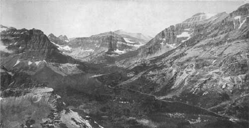
FIG. 1.—UPPER TWO MEDICINE LAKE FROM SCENIC POINT, 2,000 FEET
ABOVE THE LAKE. Rising Wolf Mountain on the right. Trail to Dawson Pass crosses at the outlet and follows the opposite side of lake to its head, then climbs up ravine to right, crossing the summit just to left of Rising Wolf. Note U-shaped valley and Upper Two Medicine Lake in cirque in left center. Photograph by M. R. Campbell. |
| <<< Previous | <<< Contents>>> | Next >>> |
adhi/intro.htm
Last Updated: —2009