|
GILA CLIFF DWELLINGS
Administrative History |

|
Chapter II:
HISTORY OF TENURE AND DEVELOPMENT 1933-1955
EXECUTIVE ORDER 6166 (continued)
1955: Roads And MISSION 66
In February 1955, the New Mexico legislature unanimously approved a house memorial—a non-binding form of legislation—that asked the State Highway Commission to construct an all-weather road from the Sapillo crossing to Gila Cliff Dwellings National Monument. [52] The urgency of this project, according to a contemporary newspaper account, stemmed from a growing popular interest in the monument and the wilderness. [53] Unlike the rough, privately financed road that had been bulldozed to the Gila Hot Springs subdivision in 1949, the new proposal sought public allocations for the construction of a road that would attract more tourists to Grant County. [54] Enticed by the prospect of more tourism, the Silver City Chamber of Commerce was already actively boosting the road proposal, and the Grant County Commission was exploring the pertinent costs of its construction. [55]
Also in February 1955, as a matter of coincidence, the American Automobile Association hosted a dinner in Washington, D.C., to inaugurate MISSION 66, a new 10-year program of the Park Service that was geared toward the construction of enough roads, visitor centers, and other facilities to accommodate the number of tourists projected to visit units in the park system in 1966—the 50th anniversary of the bureau. [56] The largest development program since the 1930s, MISSION 66 happened to require a prospectus for each of those areas, outlining its significance, its problems, and its potential.
For Gila Cliff Dwellings National Monument, Southwestern National Monuments developed a prospectus that echoed the earlier assessments of Tillotson and Miller, who was now director of the regional office:
The dwellings' well-preserved architecture and beautiful wilderness setting have combined to quiet any misgivings an analyst might develop concerning the adequacy of their national significance. [57]
Since the significance of these cliff dwellings was linked to their isolated setting, it followed then that the road memorialized by the New Mexico Legislature would diminish their status to "just another nice cliff dwelling." Therefore, the prospectus recommended that the Park Service consider transferring the archeological site to the New Mexico park system should the road ever be constructed and acquiring instead a large Mimbres pueblo site.
Campbell, who was working his first summer as a uniformed seasonal ranger, received the prospectus in early August. Recording his consternation in a memorandum and a more pointed letter sent on the same day to the general superintendent, he challenged the validity of the prospectus, noting among other things that the largely undocumented archeology of the area was far more extensive than commonly assumed and deserved a closer look. [58] With the help of Francis Parsons, president of the Grant County Archaeological Society, Campbell also identified near the monument just the kind of large Mimbres pueblo site in which the prospectus had expressed interest. In addition, he began drawing maps of all the other sites he could find. He also showed these sites to Roland Richert, a visiting archeologist from the Mobile Stabilization Unit who was supervising the stabilization work that Marjorie Lambert's 1954 lament had engendered.
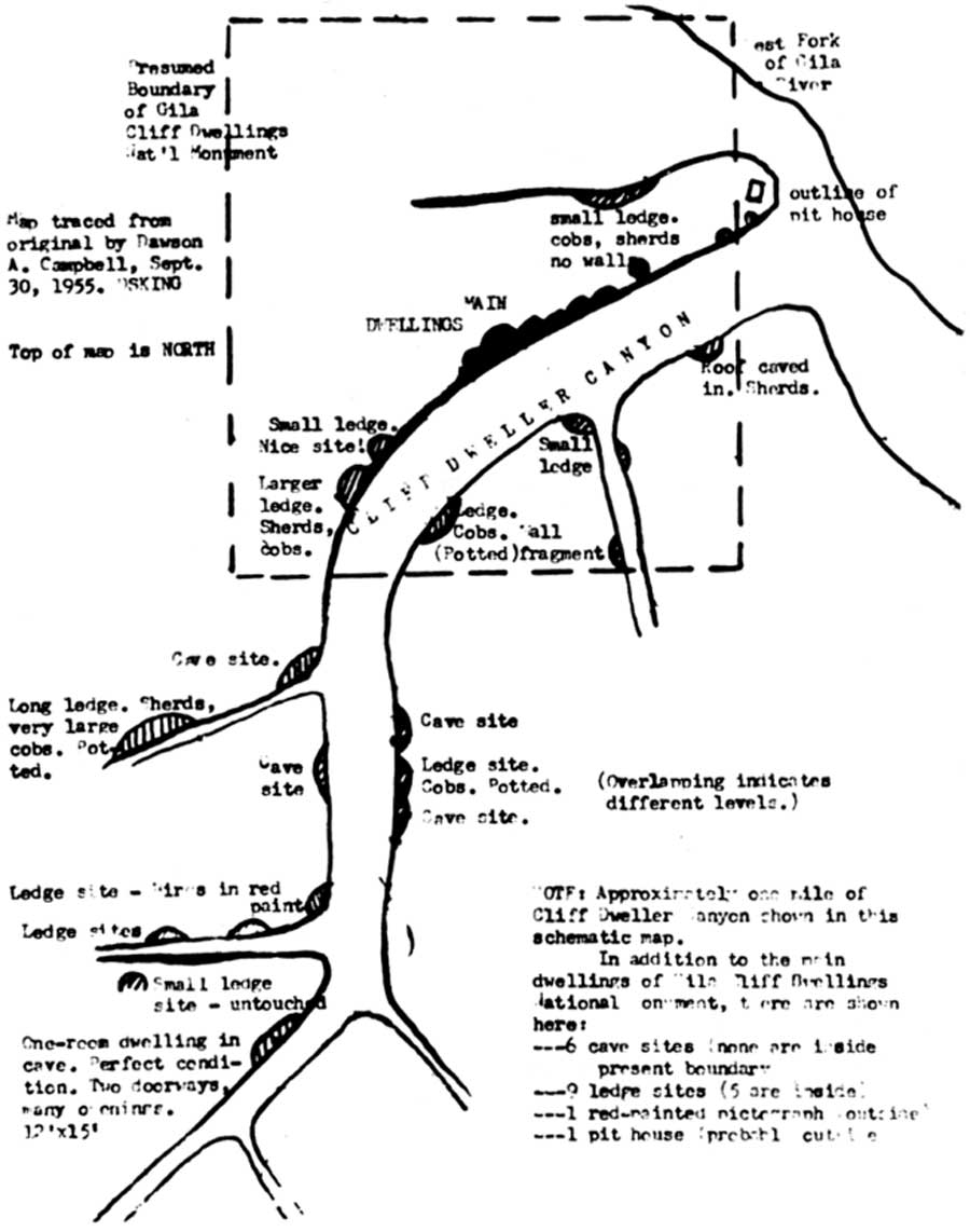 Map drawn by Custodian "Doc" Campbell. This map denoted the approximate location of far more prehistoric cultural sites in the vicinity of the monument than most people knew existed. Through Campbell's knowledge, this and other maps that he drew, and his efforts guiding professional archeologists to these sites, the initial MISSION 66 proposal was revised. Instead of suggesting a transfer of the site to a state agency, the revised proposal lead to the 1962 expansion of the monument. (click on image for an enlargement in a new window) |
With grab samples in hand, Richert enticed his immediate superior, Gordon Vivian, to spend some of his annual leave on the forks of the Gila River, beginning in this way a rapid sequence of letters and staff visits that led in November to a revised prospectus. [59] The revision was dramatic. The suggestion to transfer the monument was deleted. And the new prospectus recommended substantially expanding the unit to include new sites and especially the large and nearly pristine TJ Ruin at the confluence of the West and Middle forks. Earlier apprehensions about the national significance of the vandalized cliff dwellings yielded to a new recognition: on the upper Gila was a thickly clustered sequence of prehistoric sites, the rich legacy of a culture that was not represented elsewhere in the national park system. Not long afterwards, Conrad Wirth, the director of the Park Service, asked that the monument custodian be complimented for the vigilance that culminated in the revision of the prospectus. [60]
An interesting current also flowing through this administrative sea change was a discreet but repeated concern about the friends of local development, some of whom resided at Gila Hot Springs, and who—it was noted in the prospectus—"are exceedingly potent, who keep a close watch on National Park Service operations, and who will, whether the Service approves or not, see to it that Gila Cliff Dwellings is place prominently in the limelight, as needing preservation, interpretation, and development." [61]
Two of the well-connected friends of development were "Colonel" Clyde Ely, the editor and publisher of the Silver City Daily Press, and Chancie Snyder, who was president of the New Mexico Game Association and whose best friend and business partner was the campaign manager for Senator Clinton Anderson. Less wired politically but equally energetic was Francis Parsons, a retired architect from Massachusetts, who divided his time between the local archeological society, the city council, the chamber of commerce and boy scouts. [62] Both Ely and Snyder had summer houses at Gila Hot Springs, where other influential people lived as well. "At the time we sold this land," recalled Campbell more than 40 years later, "we had a president or active member—had past presidents—of every service organization [in Grant County]. [63]
| <<< Previous | <<< Contents >>> | Next >>> |
gicl/adhi/adhi2h.htm
Last Updated: 23-Apr-2001