
|
University of Washington Publications in Geology
The Geology of Mount Rainier National Park |
PHYSIOGRAPHY AND GEOMORPHOLOGY
(continued)
THE CASCADES
PREVIOUS LITERATURE
Practically the only reference concerning the physiographic development of the Cascades in the vicinity of Rainier is the following short paragraph by Russell (27) in the 18th Annual Report of the United States Geological Survey for the fiscal year 1896-1897:
As has been determined by Bailey Willis, the mountain stands on a slanting peneplain, which consists of granites, schists, and coal-bearing Tertiary rocks; that is the region where Mount Rainier is situated was eroded during late Tertiary times until it was reduced to a plain practically at sea level. Such a plain is known among geographers as a peneplain. This peneplain was then upraised and tilted so as to slope gently westward. Since the plain was elevated it has been deeply dissected by erosion, and the land masses between the sunken stream channels have been worn into mountain forms. The general level of the summits which mark approximately the position of the tilted peneplain, in the region adjacent to Mount Rainier, on the north, is about 6,500 feet.
The peneplain idea contained in this brief statement was destined to be the main thesis in Cascade physiography for the ensuing 30 years. Although first published by Russell, it is interesting to note that he gives full credit for the idea to Bailey Willis.
To explain this fact, it is necessary to review some of the preceding events. In 1881 and 1884, Willis had the opportunity to visit the Cascades in central Washington but "took little note of the physiographic aspects." (44) In 1892, Russell made a brief reconnaissance in central Washington, mainly in the interest of artesian water, but his observations carry no allusion to a Cascade peneplain.
In the meantime, Willis had spent eleven years in the Appalachians where peneplains are remarkably well displayed. Returning to Washington in 1895, he was impressed at once by the uniform altitudes "which might reach or fall little short of an ancient plain."
In 1898, Russell published his statement concerning the Cascade peneplain; the first mention of such a feature in the literature. Later, in 1900, after working n the northern Cascades, under the direction of Willis, Russell (26) said:
The Cascade mountains, as we know them, seem to have been carved from an upraised peneplain. This plain we term the Cascade peneplain and the plateau may be conveniently designated the Cascade plateau.
From the years 1895-1900, Willis carried on extensive field work in the Wenatchee-Chelan district. Presenting the results of his efforts in 1903, he interpreted several stages of topographic development for the eastern Cascades in which the initial stage (Methow) was a peneplain—the Cascade peneplain of Russell. This was followed by other stages of dissection; all described in considerable detail. Willis (44) infers in this paper that Russell arrived at the peneplain hypothesis simultaneously with himself, and perhaps independently, while Russell was working in the northern Cascades. It is felt that both men are responsible for the hypothesis although it is not clear as to the amount each man influenced the other.
It is noteworthy that at the turn of the century geologic investigations were confined to the eastern and northern portions of the Cascades, especially near the towns of Ellensburg and Wenatchee and farther north from Chelan to the Canadian border. Following one another in rapid succession, a number of papers appeared, involving the structural and physiographic problems of this area. These were largely the results of the efforts of Willis and Russell; however, a third man, G. O. Smith, had been working in the Cascades and continued his investigations many years after the other two men had withdrawn. Here was an excellent opportunity to test the peneplain hypothesis. Smith (31) was not convinced by such evidence as uniformity of summit levels and maintained a critical skepticism until further proof was forthcoming. His attitude is exemplified in the following paragraph:
A general uniformity of altitude of the ridges and peaks of the central portion of the Cascades may be made out in certain districts, but so frequently are other peaks seen which rise above this level that this class of evidence taken alone is far from conclusive. Indeed, this is best appreciated by those who have been most earnest in their search for traces of the old peneplain. Furthermore, the date of the supposed planation has not hitherto been determined even approximately. The identification of possible remnants of the old lowland, if such a lowland existed, becomes most essential to the investigation of the later history of the Cascade region.
The further proof which Smith demanded was later supplied by himself (32) while carrying on field investigations in the Ellensburg-Yakima district. Here the surface rocks consist, for the most part, of soft, friable sandstones and loose conglomerates of the Ellensburg formation and the hard, compact Yakima basalt. The lavas and sediments have been thrown into a series of gently dipping anticlines and synclines, trending in a northwest-southeast direction. The anticlinal ridges were thought to have been slightly elevated and then remained relatively stationary until erosion had effaced their topographic expression. According to Smith, both the compact, resistant basalt and the loosely consolidated sediments were bevelled to a common level during this erosion interval.
Smith sums up the evidence by stating: (31)
Such perfection of planation could not be expected much short of reduction to a base-level, so that the natural deduction from these observed facts is the former presence of an essentially level lowland over the area.
Going into more detail, he described a particular locality at Kelley Hollow which he regards as "the type locality for the recognition of the lowland."
After mapping the Ellensburg quadrangle, Smith (28) (33) moved northward and, in 1904, described the Mount Stuart quadrangle. In this latter publication he declares:
The approximately level plain or peneplain is excellently preserved immediately south and is fully described in the Ellensburg folio. In the Mount Stuart quadrangle, traces of the peneplain can be seen along the southern slope of Table and Lookout mountains and, on the mesa, between Yakima River and Dry Creek.
Thence, moving westward to the adjoining Snoqualmie quadrangle Smith (34) observed:
The absolute identification of this Pliocene lowland surface is difficult outside of the region bordering the valley of the lower Yakima river. In the heart of the range it cannot be recognized and the only places in the Snoqualmie quadrangle where the old surfaces may possibly remain are in the southeastern corner.
It is to be remembered that the Snoqualmie quadrangle lies immediately to the northeast of the Mount Rainier National Park sheet. The southwest corner of the former touches the northeast corner of the latter and, as may be expected, the two areas have much in common.
The preceding pages demonstrate clearly the universal acceptance of the peneplain hypothesis among the early workers in the eastern Cascades. Although cautiously avoided by Smith, a tendency existed, either consciously or unconsciously, to apply the hypothesis over the entire range. A case in point is the statement of Willis': (44)
South of the 47th parallel the extent and attitude of the peneplain are not well known, except that at an altitude of about 7,500 feet it forms the platform upon which stands the volcanic cone of Mount Rainier, and probably extends in a similar manner beneath Adams, Hood, and other volcanoes in Oregon.
The first discordant note in adherence to the peneplain idea was offered by Daly (5) in 1912. Working for a number of years along the Canadian boundary, Daly took a keen interest in the processes of alpine sculpture and felt they were sufficient in themselves to explain the present land forms, especially in regard to the accordant summits. He pointed out that seven different conditions of erosion worked together in producing an accordance of summit levels in an ideal alpine range, undergoing its first cycle of physiographic development. Carrying his ideas southward, he applied them to the findings of Willis, Russell, and Smith, and, although he never worked in the area, severely criticized their work on peneplanation. Daly (6) also objected to the shortness in time allotted to post-peneplain sculpture, wherein the plateau, raised from 4,000 to 9,000 feet lost practically all traces of its former plainlike surface.
For almost 25 years the geology of the central Cascades remained practically untouched. In the years 1925-27, Waters became interested in the Wenatchee-Chelan district and worked out the geology in detail. After obtaining accurate information regarding the underlying structure, he demonstrated in a clear and decisive manner the error of some of the former physiographic interpretations. Waters (38) remarked:
As a result of his own work in the Wenatchee-Chelan district, the writer has come to radically different conclusions as to the origin of the physiographic features of the district from those advanced by Willis.
After a careful description of each locality mentioned by Willis as remnants of the peneplain (Methow) surface, Waters concludes:
In summary, then, it may be stated that of the areas marked as remnants of the Methow plain by Willis, three are constructional surfaces of the White Hill basalt, one is a structural platform in gneiss, and the remaining groups are surfaces that represent the undissected top of the Yakima basalt with its capping of wind-blown soil. Not one of them preserves the features of an erosion surface remnant.
After visiting the locality offered by Smith as proof of planation, Waters agrees with the evidence, saying:
The writer has visited the type locality (Kelley Hollow) of this peneplain which Smith calls the Cascade lowland and can corroborate Smith's statements that the erosion surface there bevels both the upturned Yakima basalt and the unconsolidated Ellensburg strata to a common level.
Recently Waters suggested that this surface might well represent a pediment. (38)
In 1935, Buwalda (3) presented a paper concerning the postulated peneplain in the Yakima region. Quoting from the abstract it reads:
Evidence presented for peneplanation consisted of smooth, supposedly bevelled surfaces on crests and flanks of such basaltic ridges as Cleman mountain and across both basalt and sediments at one locality, Kelley Hollow, and supposed entrenched meanders of Yakima river between Yakima and Ellensburg. The writer's interpretation is that the smooth basaltic crests and flanks mapped by Smith on plate 5 are not bevelled but structural surfaces (dip slopes), locally lowered on the crests by recent stripping to an underlying basaltic layer. The supposed peneplain remnant at Kelley Hollow was cut across a small thickness of basalt in the present cycle by tributaries graded to the existing but slightly higher Wenas creek.
In summary, it may be said that at the end of the nineteenth and the beginning of the twentieth century the workers in the geology of central Washington were imbued with the idea of a former peneplanation of the Cascade range. They regarded its present surface as an expression of dissection suffered during the second stage of physiographic development. Minor modifications were attributed to transverse upwarps and anticlines. Since 1912, and especially in more recent years, this general conception has fallen into disfavor.
It is quite necessary to consider first, the pre-Rainier topography, then the river pattern, and, finally, the general structure of the range within the Park, before attempting a discussion of the peneplain hypothesis in that portion of the Cascades contiguous to Rainier.
PRE-RAINIER TOPOGRAPHY
At least during a good portion of Pleistocene time the mountain has protected 100 square miles or more of the Cascades from dissection. A search along the margin of the cone should reveal some evidence as to the character of the pre-Rainier topography. The unconformity between the Keechelus series, or granodiorite, and the Rainier lavas is usually sharply defined and may be studied at a number of localities. At the snout of the Nisqually Glacier the upper surface of the oldest rocks is but slightly above the 4,000-foot contour line while a mile farther eastward, in Paradise Valley, the contact is 5,000 feet high near the settlement of Paradise, and 5,700 feet above sea level at Sluiskin Falls. Thus the pre-Rainier relief must have been at least 1,500 feet in this particular area. Relief of a similar magnitude is shown by the contact in the Mystic Lake region. The Rainier lavas extend as far down as the 6,000-foot divide where the Moraine Creek trail crosses over to Mystic Lake. This same contact attains a height of more than 7,200 feet adjacent to the Winthrop Glacier. On the opposite side of the Winthrop, the granodiorite outcrops just below St. Elmos Pass (7,400 feet), but the Rainier lavas cover both the granodiorite and the Keechelus rocks down as low as 6,200 feet in places along the margin of Burroughs Mountain in Berkeley and Yakima Park. In Ohanopecosh Park and at Panhandle Gap the contact undulates between 6,000 and 7,000 feet.
The greatest relief, however, is preserved in the vicinity of the Tatoosh Range whose peaks average 6,500 feet in elevation. The Rainier lavas meet and closely follow the configuration of the basal and northern end of this range. On the Longmire side, the lavas from the volcano outcrop as low as 3,000 feet above sea level; while 1-1/2 miles to the eastward, at Eagle Peak, the older rocks tower 3,500 feet above the contact. In this case, a question might be raised as to the possibility of uplift subsequent to the outpourings of the Rainier lavas. The idea of faulting along the northern face of the range was entertained by the writer during the first few weeks of field work while mapping in the Paradise-Indian Henry region. The seemingly straight and abrupt escarpment, as viewed from the northward, suggested a fault block origin for the range. Later, while searching for evidence to either confirm or deny this interpretation, all proof tended to point away from this fault block conception.
The view from any of the peaks from Eagle to Stevens shows the plan of the Tatoosh Range to be that of a large "U" with only the curved portion, or the bend in the letter falling within the Park. The two prongs of the letter point southward and are separated from each other by the canyon of Butter Creek.
Such a shape is far from characteristic of fault block mountains. Even the steep northern face of the Tatoosh was found to differ little from its many neighbors, such as the Sourdough Mountains and the Cowlitz Chimneys. This abruptness of the northern faces of so many of the ranges is thought to be due to causes other than faulting and will be described later in this chapter on physiography.
A second point against faulting is provided by the contact of the Rainier lavas and the granodiorite on the north side of the Tatoosh Range. One of the most accessible exposures showing this relationship is at Narada Falls. Here the Rainier lavas are decidedly columnar with the long axis of the columns oriented at right angles to the steep surface of the granodiorite. The Paradise River flows across the lavas and at Narada Falls plunges over the ends of the columns into the narrow gorge marking the boundary between the lavas and the granodiorite. The ends of the columns abutting against the granodiorite show no evidence of post-Rainier faulting, but, instead, display an undisturbed attitude with the normal chilling effects.
A third point against post-Rainier faulting is indicated by the tongues of lava both to the east and to the west of the range. If a hypothetical fault plane were extended, for example, into the Ramparts, there should be a marked displacement in these lavas. On the contrary, no uplift of the southern portions of these tongues can be discerned. This evidence points away from a post-Rainier faulting. Uplift by folding is also untenable as forces of sufficient magnitude to bow up so great a range would cause marked warping or intense folding in the surrounding lava tongues.
In summary, and, considering the above evidence, the general relief prior to the outpouring of the Rainier lavas is considered to have been from 1,000 to 3,000 or more feet.
The Mount Rainier-Cascade contact around the mountain undulates in an irregular fashion between elevations of 3,000 and 7,000 feet. The lowest point is near Longmire on the southwest side of the mountain while the highest is on the north and west sides in the Summerland-Steamboat Prow-Winthrop Glacier region. Thus the buried topography might well have had a relief of 4,000 feet.
PRE-RAINIER RIVER PATTERN
On the eastern side of the Cascades, the rivers, with but few exceptions, are guided in their courses by the underlying structure which trends generally in a northwest-southeast direction. On the western side of the range, this condition is not so pronounced and it is believed that the streams are more consequent, merely draining the westward slopes of the Cascades and paying little heed to the underlying structure. Such rivers as the Skagit, Nisqually and Cispis are offered as examples. In so far as the structure has been determined, these rivers pass over hard and soft rocks alike. In the Park the pre-Rainier drainage pattern was not unlike that of the western Cascades at the present time. Although the major rivers had not entrenched themselves as deeply into the range as those found today, nevertheless they are thought to have been parallel and pursued a consequent westerly course as a result of the general north-south upwarp of the Cascades.
Two rivers, the Cowlitz and the White, are rather exceptional because of their wide swing or detour around the Park. The former originates in the glacier by the same name and parallels the main divide of the Cascades for 12 miles before swinging westward in a sweeping arc and finally emptying into the Columbia River. The latter emerges from under the Emmons Glacier, flows eastward up to within 3 miles of the Cascade divide, turns northward for a distance of 20 miles, then westward until it empties into Puget Sound.
At first glance, the courses of these rivers would probably be attributed to the influence of Mount Rainier as the result of superimposing a radial drainage pattern on one in which the original streams were essentially parallel and westward flowing. However, certain evidence suggests that the courses of these rivers were determined prior to the formation of Mount Rainier.
An examination of the topographic maps, both to the north and to the south of the Park, indicates a difference in elevation of the Cascade peaks; those adjacent to Mount Rainier being somewhat higher than those farther removed. Such peaks as the Cowlitz Chimneys, Goat Island Mountain, the Palisades, Old Desolate, and the like, are all within the Park and all average more than 7,000 feet in elevation. To the north, in the Cedar Lake quadrangle, the highest peak to the north of the White River is Mount Defiance with an elevation of 5,590 feet. In the opposite direction, and south of the Cowlitz River in the Steamboat Mountain quadrangle, the highest peaks attain an elevation of approximately 5,700 feet; Mount Adams excepted. Thus the peaks contiguous to Rainier are at least 1,000 feet higher than those farther to the north or to the south.
This mass may be considered, therefore, as a positive area or one which has been raised above the adjoining territory (probably by warping) in a system where differential uplift is not uncommon. (Cf. Snoqualmie Folio, page 12.) The exact time of elevation, whether it he pre- or post-Rainier, or an attendant phenomena associated with the formation of the volcano, is a moot question. However, an early a time as possible is looked upon with the greatest favor for the following reasons:
Consider for a moment the depth to which the above mentioned rivers have entrenched themselves in the Cascade upland. The Cowlitz has an elevation of only 1,054 feet at Lewis, located several miles east and south of Mount Rainier. Here the river is a braided stream, lazily winding across its wide flood plain. Because of the width of the flood plain, the local inhabitants refer to this feature as the Big Bottom country.
The entrenching of this river 4,000 feet into the Cascades has been a lengthy process, and, added to this, is the time-consuming work of valley widening. Perhaps even a better conception of the relative ages of the river and Mount Rainier is afforded by comparison with the Nisqually, as the relations of the latter are well known and easily observed. From facts gathered within the Park, and presented above, the valley of the Nisqually was shown to have been carved to a depth of several thousand feet in the older (Keechelus) rocks. At a distinctly later time, tongues of lava from the volcano flowed into this old valley, partially filling it. (Note, especially, the Ramparts on the geological map.) This type of evidence points to a pre-Rainier origin for the Nisqually Valley.
The Cowlitz Valley is not markedly different from the Nisqually. Both streams are firmly entrenched; their courses are fully graded up to within a few miles of their sources and each has commenced the tedious work of valley widening. If any discrepancy in time does exist within the two, the Cowlitz should be favored with the greater age. It has not only cut 1,000 feet lower into the range but also has greatly exceeded the Nisqually in valley widening. All this was accomplished under the handicap of a greater distance to base level; the former river being more than twice as long as the Nisqually.
Even more direct evidence as to the pre-Rainier age of the Cowlitz is afforded by the tongue of Rainier lava occupying the Muddy fork of the river. The eroded ends of the flows extend down as low as 3,000 feet, and it follows that the lower course of the river must have been below that figure prior to lava-filling. If the valleys previously drained to the northwest, instead of to the south, as they now do, then the later lava flows would probably dam the valleys and lakes would have been formed. This, however, does not seem to have been the case. No lakes are present now and it is doubtful if these valleys were ever filled with water as a result of lava damming.
It is felt that the presence of these lava tongues occupying previously deep valleys in the older rocks is sufficient proof to warrant the interpretation of a well-established drainage pattern prior to the outpourings of the Rainier lavas. As the White River is almost identical to the Cowlitz, it is not considered as being worthy of special mention.
In summary, the writer postulates that drainage channels marked the pre-Rainier surface of the Cascades, producing a relief varying from 1,000 to 2,000 or more feet. The river pattern in a wide radius about Mount Rainier is that of a series of parallel and westward flowing streams. Such an arrangement suggests a normal, consequent drainage on the western side or slope of the range. Modifying this general pattern is the high land mass on which the volcano is located, causing certain rivers to be deflected in sweeping arcs around the Park before resuming their westward journey in common with the other Cascade rivers.
|
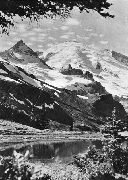
| FIG. 25. Lake Leigh from near Panhandle Gap. (Looking west toward the mountain; Little Tahoma on the left. Note the flat-topped surface in the right foreground; this is one of the many stubs of the Keechelus surface on which the Rainier lavas were deposited.) |
PRE-RAINIER STRUCTURE
The structure of the upper portion of the Cascades adjacent to the mountain has been mentioned in the section dealing with the Keechelus series. It is desirable to reiterate briefly this information as the structure of this formation is frequently expressed in the topography of the present Cascades.
The lower portion of the Keechelus, averaging 2,000 feet in thickness, is composed of extremely massive porphyries and breccias. Any indication of attitude is usually lacking but, when it can be ascertained, a moderate folding is usually indicated. The younger facies of this formation is a series of lava flows totalling 300 feet or more in thickness. These lie in a horizontal position or are thrown into gentle folds. Both old and young facies are amply exposed; the older forming extensive outcrops in the southern half of the Park and the younger in the northern half.
Undissected remnants of the upper Keechelus flows are well preserved at the following localities:
At Panhandle Gap, from 7431 down to the divide, where the Wonderland Trail crosses from Summerland to Ohanepecosh Park, the dip slope of the lavas and the surface coincide, both dipping approximately 13° to the west.
From the Palisades over toward Marcus Peak, a structural saddle in the Keechelus is well-preserved and is expressed topographically.
Dip slopes are also indicated in Moraine Park, Bee Flat, Goat Island Mountain, the north side of Yellowstone Cliffs, and many other localities too numerous to mention.
Many stubs of the Keechelus surface, too small to be represented on the topographic map, are scattered about the Park. (Cf. Panhandle Gap, Figure 25.)
Unfortunately, most of the remaining peaks have been so modified by glaciation that any suggestion of structural control of their form has been effaced. Examples are found in peaks like Mother Mountain, those in Chinook Pass, Unicorn Peak, and the like. Although lacking in structural control, the horizontal or slightly warped position of the lavas in these peaks is readily observed.
It is to be expected that in pre-Rainier (and also pre-glacial) time the topography would be controlled, in a large measure, by the attitude of the younger Keechelus flows comprising the upper surface of the Cascades, especially in the northern half of Mount Rainier National Park. The structural surfaces of these flows at that time were probably little modified and far more extensive than the meager remnants we have today. The influence of the local warpings undoubtedly was reflected in the courses of the rivers. However, other forces were active, also, culminating in a general north-south uplift, and probably overshadowing any widespread attempt at structural control of the rivers.
CONCLUSIONS
In conclusion, the present, as well as the pre-Rainier surface of the Cascades is regarded as being due to a number of processes. The older porphyries and breccias of the Keechelus series have had a long and complicated history. Where their structure can be determined, (and this is better observed outside the Park than within), these older rocks have suffered pronounced folding, and possibly concommitant igneous invasion. Much less disturbed are the younger and capping lava flows of this same series which either retain their horizontal position or have been gently warped into low, undulating folds. Both the older and younger facies of the Keechelus were uplifted, probably a number of times and different amounts in the various areas, but sufficiently to cause vigorous dissection to be initiated. This resulted in canyons and valleys being carved to a depth of 3,000 feet into the upland. In the vicinity of Mount Rainier, the Cascades are regarded as now being dissected to maturity in the first cycle of physiographic development.
As pointed out by Daly, (5) the accordance of summit levels, so often mentioned in the literature, should not be construed as meaning an equality of heights. The Cascade peaks within the Park vary from 4,500 to well over 7,000 feet in elevation. The higher of these are not segregated to any particular area but are intimately admixed with the lower ones. Thus an imaginary surface determined by the summits of the peaks and ridges would have a relief of 2,500 feet.
The greater portion of the Cascades adjacent to Mount Rainier are composed of massive Keechelus rocks wherein the pyroclastics and breccias have been so indurated that they differ little from the flows and porphyries in hardness.
In a mountain range 6,000 feet in elevation and in which the rocks are relatively homogeneous in offering resistance to erosion, it is felt that a relief of 2,500 feet in the summit levels is to be expected in the normal processes of erosion in the first cycle. It does not seem that the accordance is sufficiently striking to demand the introduction of the n+1 cycle.
The writer prefers to account for the summit levels within the Park as a constructional, rather than a destructional, feature and resulting from the outpouring and accumulation of volcanic material. This upland has subsequently undergone a minor amount of deformation in the form of gentle warping. Since the time of inception, it has been deeply dissected by the action of streams and ice, resulting in the present topography.
The writer concurs with Smith in regard to the bevelling, so often quoted from the Yakima and Wenatchee-Chelan districts, as finding no expression near the main divide of the Cascade Range. No evidence has been found supporting peneplanation in Mount Rainier National Park, and to the northeast in the Snoqualmie quadrangle Smith finds: (34)
The absolute identification of this Pliocene lowland surface is difficult outside of the region bordering the valley of the lower Yakima River. In the heart of the range it cannot be recognized.
SUMMARY
In the preceding discussion, evidence has been presented which points to the seeming accordance of summit levels in the Cascades contiguous to Rainier, as being the result of aggradational agencies, largely in the form of lava flows. This differs from the commonly held belief that the surface was degradational in character and shaped by long, continued erosion to a featureless plain. At this point the writer wishes to emphasize the fact that no attempt is being made to disprove the existence of a Cascade peneplain and this is especially true of the eastern portion of the range. It is felt, however, that evidence is not only lacking to establish the presence of a former peneplain near Mount Rainier, but that the introduction of such a feature is, indeed, unnecessary to account for the present surface of the range.
Bearing more directly on the general peneplain problem is the work now being carried on by Professor J. H. Mackin of the department of geology of the University of Washington. His conclusions will be based on field work and on the interpretation of an extensive series of projected profiles across the Cascades.
| <<< Previous | <<< Contents >>> | Next >>> |
state/wa/1936-3-2/sec2a.htm
Last Updated: 28-Mar-2006