
|
University of Washington Publications in Geology
The Geology of the San Juan Islands |
TRIASSIC SYSTEM
(continued)
QUATERNARY SYSTEM
In many places the islands of the San Juan group are covered with a deep mantle of glacial till and sediments. The glacial geology of Puget Sound and vicinity has been discussed at some length by Bretz30 and a bibliography of previous writers on the subject may be found in his report.31
30Bretz, J. Harlen, Glaciation of the Puget Sound Region: Wash. Geol. Survey Bull., 8, 1913.
31Ibid., pp. 10-12.
Although at least four major periods of glaciation are recognized in many parts of North America, but two have been established as occurring in the Puget Sound region. The sediments and till derived from these glacial invasions have been grouped as follows:
(1) The Colwood sediments, deposited since the retreat of the last glacier.
(2) The Vashon till and sediments, deposited by the last glacier.
(3) The Puyallup sediments, deposited during the interval of time between the Admiralty and Vashon glacial periods.
(4) The Admiralty till and sediments, deposited during the next preceding glacial period or epoch.
A number of small remnants of strongly indurated tillite occur on Burrows Island and also on Allan Island. These remnants of tillite do not occur in contact with the more recent glacial till or sediments. They are found only on the south or protected slopes of the hills, and they occur as pockets on the underlying rocks of the Fidalgo formation. The fragments of the tillite are as strongly cemented as those of the conglomerates occurring in the Nanaimo series. The cementing material or matrix of the tillite is light gray in color and somewhat calcareous. Whether these remnants of tillite belong to the Admiralty glacial period, or to an earlier glacial period, is not known.
The glaciers performed a large amount of erosion in the general region of the San Juan Islands, overriding the highest mountain tops and greatly modifying the earlier topography. The glacial erosion was noticeably more intense at the southern ends of the islands, while the northern ends are often covered with glacial drift. The great bulk of these sediments was deposited during the Puyallup interglacial epoch, and they are usually covered with a thin layer of Vashon till. In places the Vashon till and sediments contain huge erratic boulders.
The direction followed by the upper portions of the glacial ice in this region was not controlled by the underlying topography. The courses of the deepest glacial erosion were partly determined by the presence of fault or fracture zones or by previously existing valleys or channels. Near sea-level the glacial striations usually follow parallel to the courses of the present water channels, while at higher elevations the striations trend nearly north and south. In the northwest portion of the map-area the course of the glacier was slightly east of south. In the southwest portion the striations trend almost exactly north and south, and do not give any indication that part of the ice sheet turned southwestward through the Strait of Juan de Fuca.
Glacial grooves with a depth of several feet are encountered in many parts of the region. Perhaps the most remarkable display of glacial grooving is found on the rocky slopes to the east of Iceberg Point on Lopez Island. Here the glacial striations trend almost at right angles to the strike of the upturned strata of the Leech River group.
On the southeast portion of Orcas Island, to the north of Obstruction Pass, the rocky hills are drumlinoidal in shape and polished by glacial action.
On San Juan Island Bretz recognized two localities, Cattle Point Hill and Bald Hill, as the best examples of recessional moraines occurring in the Puget Sound region.
The sediments occurring on Waldron Island, Lopez Island, Guemes Island, Sinclair Island, Portage Island, and Decatur Island belong largely to the Puyallup inter-glacial epoch. In most cases these sediments are overlain by a layer of till deposited as recessional morainal material by the Vashon glacier.
Since the last glacial period there has been a general uplift throughout all of the area previously covered by the ice. At several localities high above the present sea-level on Waldron Island, the Sucia islands, San Juan Island, Lopez Island and Orcas Island, there are abundant marine fossils. Of these, Pecten hastatus, Cardium corbis, Paphia staminia, and Saxidomus giganteous are the most abundant. At one locality near Deer Harbor Bretz found marine shells in a well at an elevation of 290 feet.
The San Juan Islands exhibit abundant and excellent examples of recently upraised beaches. These usually occur at elevations of 15 to 25 feet above present high tide.
|
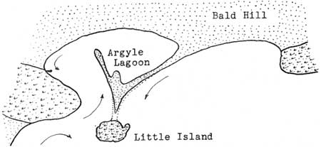
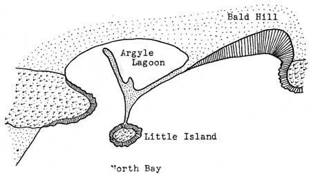
| Figure 6. The Argyle Lagoon and sandspit. |
At the present time, some interesting sandspits and lagoon lakes are being formed in the San Juan Islands. Among these, the Argyle Sand Spit and Lagoon on San Juan Island, and Fisherman Bay on Lopez Island, are the most interesting.
|
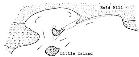
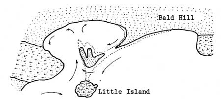
| Figures 7, 8, 9. Three stages in the evolution of the Argyle Lagoon. The arrows show the direction of the prevailing currents. |
The Argyle sand spit would have closed the entrance to the bay had it not been for the presence of Little Island which is composed of solid rock. Practically all of the materials composing the sand spit and sandy hook were derived from Bald Hill.
|
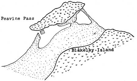
| Figure 10 The lagoon and sandspit at the north end of Blakeley Island. |
At the north end of Blakeley Island a small rock mass has been tied to the main island by means of sand spits. A similar physiographic feature is encountered on the south shore of Orcas Island about three-quarters of a mile to the east of the village of Orcas.
Double sand spits converging to a point and containing a shallow lagoon between them, are of very common occurrence in the San Juan Island area. In many cases the lagoons have been filled up with sediment so that they no longer contain any water.
At several places along the shores of the San Juan Islands, clam beds uplifted above the present high tide-level are seen to grade downward into beds that now contain living clams of the same species. Care must be used that such deposits are not confused with the so-called "kitchen middens," or shells left by the Indians who formerly camped along the shores.
At the eastern margin of the map-area the deltas of the Samish and Nooksak rivers are at the present time encroaching on some of the San Juan Islands. The Samish delta has already encroached to such an extent that shallow water and luxuriant growths of eel-grass extend almost as far west as Guemes Island. Nooksak River, with its distributary, Lummi River, are supplying so much sediment that a submerged sand bar connecting Lummi Island with the mainland is now in the process of formation.
| <<< Previous | <<< Contents >>> | Next >>> |
state/wa/uw-1927-2/sec3d.htm
Last Updated: 28-Mar-2006