
|
Washington Department of Natural Resources Geology and Earth Resources Division Bulletin No. 66 Geology of the Washington Coast between Point Grenville and the Hoh River |
PART II
Geologic Observations and Interpretations Along Segments of the Coast
TAHOLAH TO CAPE ELIZABETH
NORTH SIDE OF QUINAULT RIVER AT TAHOLAH
North of the Quinault River, immediately across from the town of Taholah and eastward nearly to the highway bridge, Hoh rocks are exposed in scattered outcrops along the riverbank, and occasionally in the heavily vegetated bluffs above. In this area most of the outcrops appear to be resistant blocks of sandstone. They are most likely from deposits of intensely jumbled rock (see Part I, Tectonic melange of the Hoh rock assemblage).
Westward from these outcrops of Hoh rocks and across the river from Taholah, the younger Quinault Formation is again exposed in the low-lying cliffs for a distance of about one-half mile. Here, the formation is largely a massive siltstone, similar to that exposed in areas south of Taholah. Because this siltstone is structurally weak, a number of landslides have developed and therefore drunken forests are common in this area too. Young deposits of sand and gravel also overlie these outcrops of the Quinault Formation.
About a quarter of a mile northwest of the mouth of the Quinault River the Quinault Formation is in contact with the underlying dark-gray, slumped, and completely jumbled Hoh rocks. Here, the Hoh rocks are so broken and structurally weak that they are flowing outward much as a mudflow. Freshly broken pieces of siltstone from this outcrop usually produce a distinct petroliferous odor. The outcrop area of these rocks extends westward for about 200 yards where it ends abruptly against a nearly vertical north-trending fault scarp formed by more resistant and gently dipping beds of sandstone and conglomerate of the Quinault Formation (fig. 37).
GARFIELD GAS MOUND
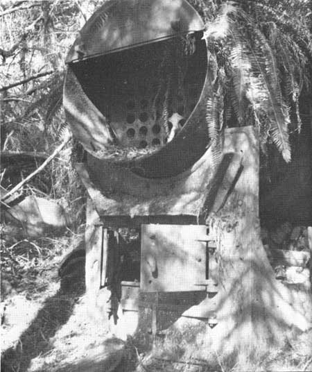
The Garfield Gas Mound, one of the few natural gas seeps in Washington State, lies in the woods about one-quarter of a mile north of the beach near the mouth of the Quinault River. It measures several hundred feet in diameter and rises some 50 feet above the surrounding terrain. This mound has been built up, over the years, from the extrusion of mud from a small vent located near the top. Natural gas (largely methane) bubbles from this mud-filled vent. In 1913, two oil test wells were drilled nearby to depths of 560 feet and 820 feet, but no petroleum was produced. Equipment used in these operations can still be seen in the woods (fig. 38). The gas undoubtedly is derived from Hoh rocks, and may possibly be seeping up along the fault seen on the beach between Hoh rocks and the Quinault Formation to the west.
|
| REMAINS OF A BOILER, used in connection with unsuccessful drilling operations for petroleum in 1913, located in the woods a short distance north of Taholah. Firewood, badly rotted but still recognizable, is stacked nearby. Small amounts of gas still bubble from the wellhead a short distance away. (Fig. 38) |
CONGLOMERATES OF THE QUINAULT FORMATION
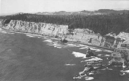
Sandstone and conglomerate beds of the Quinault Formation are in fault contact with the small outcrop of jumbled Hoh rocks that is exposed along the coast just north of the mouth of the Quinault River (fig. 29). This gently southeastwardly dipping series of beds is some 1,600 feet thick. It is continuously exposed from the contact with Hoh rocks northwestward to and including Cape Elizabeth, forming the high cliffs and rocky beaches of this area (fig. 17). The sequence also extends northward up the coast forming particularly high cliffs for nearly 1-1/4 additional miles (fig. 39). At its northernmost extent the lower part of the sequence is also in fault contact with Hoh rocks. This large, continuously exposed sequence of the Quinault Formation is the youngest known part of the formation (fig. 14) and most likely was deposited during the latter part of the Pliocene Epoch, perhaps some 2 to 5 million years ago (fig. 2).
|
| GENTLY DIPPING SANDSTONE AND CONGLOMERATE BEDS of the Quinault Formation exposed in the high vertical cliffs northward from Cape Elizabeth. (Fig. 39) |
Along the beach north of the Quinault River and westward to the Cape, the formation is largely conglomerate with some sandstone and minor amounts of siltstone. The surfaces between these major rock types are frequently irregular or channeled, indicating a varying environment of shifting deposition and local current erosion. Much carbonaceous material occurs throughout the rocks. In places large concentrations of coalified limbs, logs, and even stumps can be seen (fig. 16). Marine fossils are extremely rare occurring mostly in rocks near the Cape and northward. The lack of marine fossils in the eastern (upper) part of this sequence suggests that the materials may well have been deposited on land but perhaps immediately adjacent to the sea. Marine fossils, although rare, in the middle and lower (northern) part of the sequence indicate deposition in the sea, but almost certainly in a very shallow environment, perhaps tidal or, in places, slightly deeper. Overall, this sequence of generally coarse sedimentary rocks probably represents the last stages of the gradual filling of a marine basin. The final beds probably were deposited by streams above sea level.
DIFFERENTIAL EROSION
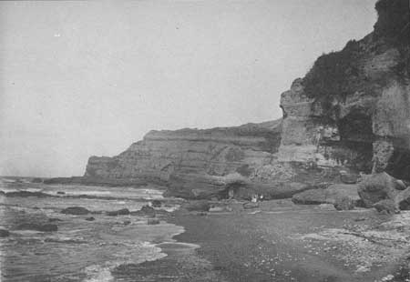
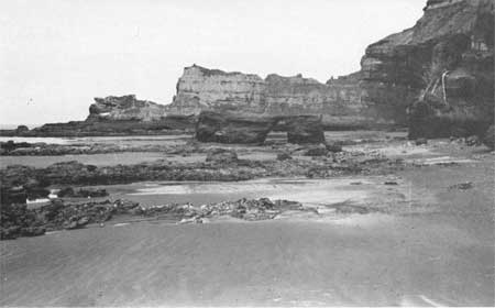
Excellent examples of the effects of erosion by wave action and other agents on different rock types can be seen westward to and particularly at Cape Elizabeth. Resistant beds of gently dipping conglomerate form many ribs on the wave-cut tidal flats. Several minor promontories, largely of conglomerate, extend out from the general line of the cliffs. It is interesting to note the amount of change these promontories have undergone over the years. Figure 40 was photographed about 1900 in the Cape Elizabeth area, and figure 41 was taken from nearly the same place in 1972. Probably the most striking change at Cape Elizabeth over the past 70 years has been the development of a wide gap as seen today and shown in figure 43, from what used to be a large natural arch as shown in figure 44.
|
| SANDSTONE AND CONGLOMERATE CLIFFS of the Cape Elizabeth area. This photo was taken about 1900. (Courtesy of the Washington State Historical Society.) Compare with figure 41, the same view taken in 1972. (Fig. 40). |
|
| LOOKING NORTHWESTWARD AT CAPE ELIZABETH, 1972. Erosion on these sandstone and conglomerate beds over a period of some 70 years has made a marked difference in this view (compare with figure 40). Note the changes in Cape Elizabeth in the background as well as the smaller point in the foreground. The gap in the nearby point did not exist in 1900. Furthermore, the main part of the adjacent cliffs appears to have receded noticeably land-ward. (Fig. 41) |
Remnants of resistant beds of Cape Elizabeth extend seaward in a southwesterly direction forming the offshore Sonora Reef. It was behind this sandstone and conglomerate reef that Cuadra on July 13, 1775 took precarious shelter in his small (36-foot-long) schooner, the Sonora.
RECENT UPLIFT
The cliffs are particularly high in the Cape Elizabeth area, reaching a height of some 200 feet in places. The same deposits of sand and gravel that occur along the coast to Point Grenville form the upper 30 to 50 feet in the cliffs of the Cape Elizabeth area. Today's generally flat land surface on top of these deposits some 200 feet above sea level was developed largely as a piedmont surface some 17,000 years ago. Here this surface is about 100 feet higher than it is in the area to the south. Furthermore, the trace of the old wave-cut surface, formed on bedrock and on which the sand and gravel now rests, is also higher in the cliffs of this area than to the south. Therefore, because both the depositional surface on top and the erosional surface below are higher locally, geologists conclude that over the past thousands of years these rocks have been elevated in the Cape Elizabeth area by the gentle warping of the earth's crust.
| <<< Previous | <<< Contents >>> | Next >>> |
state/wa/1973-66/sec2-3.htm
Last Updated: 28-Mar-2006