
|
Washington Department of Natural Resources Geology and Earth Resources Division Bulletin No. 66 Geology of the Washington Coast between Point Grenville and the Hoh River |
FOREWORD
|
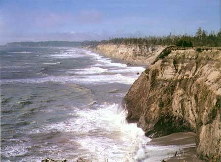
| LOOKING NORTH FROM POINT GRENVILLE TO CAPE ELIZABETH. The bedrock of Point Grenville, in the foreground, is volcanic in origin and was solidified on the sea floor some 45 to 50 million years ago. Northward along the coast the bedrock of the cliffs is gently dipping sandstone and siltstone beds of the Quinault Formation. These rocks were originally sediments that were deposited in the sea about 5 million years ago. The rocks of Cape Elizabeth in the distance are largely sandstone and conglomerate, also a part of the Quinault Formation. Overlying the bedrock all along this coast are deposits of sand and gravel that were laid down by streams from glaciers during the Pleistocene Epoch some 17 to 70 thousand years ago. |
"From hence [Point Grenville], as we proceeded to the north coast began to increase regularly in height. . . . The shores we passed this morning . . . were composed of low cliffs rising perpendicularly from a beach of sand or small stones; had many detached rocks of various romantic forms lying at a distance of about a mile. . . ."Captain George Vancouver's description of the coastal area between Point Grenville and Destruction Island, April 28, 1792.
The picturesque rock formations so prominent along the Washington Coast have undoubtedly aroused the curiosity of many people. Needless to say, geologists have been particularly intrigued and challenged to learn about the origin and history of these geologic features.
This report summarizes known geologic facts, as well as theories applied by geologists in their attempt to unravel the geologic history of the rocks exposed in this part of Washington State. Although it is designed primarily for students and enthusiasts of the natural sciences, it nevertheless should be of general interest to many other readers. Those wishing to learn about a particular geologic feature or segment of the coast will find Part II especially informative. Furthermore, this section may well serve as a field guide for classes in geology. Finally, each illustration and caption tells a story in itself.
The report is an outgrowth of geologic mapping and technical studies that the Geology and Earth Resources Division is conducting along the coast and in adjacent inland areas to provide basic geologic data for future planning and for solutions to geologically related problems. The project is being conducted by Dr. Weldon W. Rau, a geologist on our staff for the past 13 years. He has devoted his entire professional career, including 10 years with the U.S. Geological Survey, to studying and writing about geology of the Pacific Northwest. He therefore is well qualified to present this geologic summary, which we hope will provide a better understanding and enjoyment of one of the natural areas of the Washington coast.
VAUGHN E. LIVINGSTON, JR.
Washington State Geologist
June 29, 1973
| <<< Previous | <<< Contents >>> | Next >>> |
state/wa/1973-66/foreword.htm
Last Updated: 28-Mar-2006