
|
Washington Department of Natural Resources Bulletin No. 62 Foraminifera, Stratigraphy, and Paleoecology of the Quinault Formation, Point Grenville-Raft River Coastal Area, Washington |
INTRODUCTION
LOCATION AND ACCESS
Outcrops of the Quinault Formation occur largely in sea cliffs and on the beaches of the Washington coast between Point Grenville and a point about 1 mile north of the mouth of the Raft River within the Quinault Indian Reservation (Fig. 1). Also, a few small isolated outcrops occur to the south between Point Grenville and Moclips, Washington. With the latter exception, practically all outcrops of the formation are in the Taholah 15-minute quadrangle and lie within Tps. 21, 22, and 23 N., R. 13 W.; and between latitudes 47° 15' and 47° 30' N., and longitudes 124° 15' and 124° 25' W. Eastward from the coast, thick deposits of sand and gravel almost completely cover the area, and nowhere in the Taholah quadrangle are outcrops of the Quinault Formation known more than 3 miles from the coast. Most inland outcrops of the formation are in secs. 2, 3, 9, 10, 11, 15, and 22, T. 22 N., R. 13 W.
Access to the reservation, with the permission of the Quinault Tribal Council, is largely by logging roads; the partly constructed State Highway 9-C; and usable parts of the "Cape Elizabeth" road, which parallels much of the coast in this area. The beaches can be approached at only a few places, because of the high, nearly vertical sea cliffs in much of the area. All beaches are accessible at low tide with the exception of a stretch of beach about a quarter of a mile long at Pratt Cliff, where most of the cliffs plunge directly into the sea. A continuous section of the Quinault Formation is exposed in these cliffs, but, unfortunately, during the investigation for this report it could be viewed only by helicopter, so measurements of this section were estimated from attitudes available at the north and south ends of this inaccessible area.
FIELD WORK AND ACKNOWLEDGMENTS
Geologic field studies in the area of the Taholah quadrangle began in the summer of 1967, during which time most of the sections discussed in the report were sampled and measured. Additional data were gathered for the study during the summer months of 1968 and 1969, while primarily investigating the general geology of this and surrounding areas.
The cooperation of the Quinault Tribal Council in granting access to the reservation and the guide services and general assistance of many of the local residents are greatly appreciated. The Aloha Logging Company and the Washington State Highway Department were most helpful in supplying road maps and access to locked areas. Several oil companies aided greatly in many ways. Particular thanks are due D. B. Braislin, of the Union Oil Company of California, for making available comparative foraminiferal materials and for offering helpful comments. The general assistance and constructive discussions of J. R. Sprague, A. D. Horn, and R. S. Boettcher, of the Mobil Oil Company, are greatly appreciated. All staff members of the Washington Division of Mines and Geology have aided in various ways in the preparation of this report. Particular thanks are due to M. T. Huntting, Supervisor, for his editorial comments and for administrative assistance connected with the publishing of this report. The capable assistance throughout the summer months of J. P. Braislin in 1967 and of G. D. Cloud during 1968 and 1969 is gratefully acknowledged. All photographs of Foraminifera accompanying the report were retouched by D. A. Winsor.
PURPOSE, METHOD OF STUDY, AND SCOPE
|
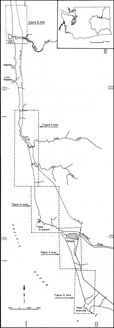
| FIGURE 1.—Index map of the five outcrop areas of the Quinault Formation discussed in this report. (click on image for an enlargement in a new window) |
Comprehensive geologic investigations are being undertaken by the Division of Mines and Geology of the Washington State Department of Natural Resources in a major segment of the westernmost part of the Olympic Peninsula to provide a basis for evaluation of oil and gas possibilities of the area, as well as other mineral resources. These more extensive geologic investigations are being conducted between Point Grenville and the Hoh River and extend eastward into the foothills of the Olympic Mountains.
Detailed information on the stratigraphy and foraminiferal distribution of the Quinault Formation exposed in this area is of particular importance, because known onshore outcrops of the formation are confined almost entirely to this area. However, equivalent strata are widespread to the west on the Continental Shelf, where investigations are limited largely to drilling and geophysical operations. Furthermore, in the subsurface of both onshore and offshore areas, these rocks are potentially favorable as a reservoir for oil and gas.
The Quinault Formation is exposed in four major and separate sections along the Washington coast. Each of these sections was sampled thoroughly for Foraminifera, and its thickness was computed from a Brunton compass and tape traverse. The 57 foraminiferal species illustrated and discussed in this report are from 101 localities within these 4 sections and nearby isolated outcrops. Based on faunal composition of the formation and the distribution of the various species of Foraminifera within each section, a general history of deposition is constructed for the containing sediments. Broad correlations of the Quinault Formation are made with similar beds of other areas on the Pacific coast, and suggestions are presented regarding its relative geologic age. Furthermore, ecological conditions under which the sediments in the various sections were most likely deposited are determined by an evaluation of the composition of the containing foraminiferal faunas.
PREVIOUS WORK
Arnold (1906) first applied the name Quinault (Quinaielt) Formation to the strata exposed between Cape Elizabeth and Point Grenville which he described as more than 2,200 feet in thickness and composed of conglomerates, shales, and some sandstone. As an equivalent, he also included concretionary sandstone at the mouth of the Raft River. On the basis of megafossils from the formation, he referred the Quinault Formation to the Pliocene and correlated it with the Purisima Formation of central California.
Reagan (1909) followed Arnold's concepts of the Quinault Formation, but regarded beds in the vicinity of the mouth of the Raft River as the Raft River Formation.
Arnold and Hannibal (1913, p. 589, 592) referred at least some of the strata formerly called Quinault Formation to the Empire Formation (Miocene). They stated: "Small Empire areas occur...between Cape Grenville and the mouth of the Quinault River, between Cape Elizabeth and Raft River, and at the mouth of Raft River." They also referred broadly to some of the beds near Taholah as the Merced Formation (Mio-Pliocene) for which they estimated a thickness of some 500 feet.
Lupton (1914), in his reconnaissance study of the Olympic coastal area for oil and gas, described the rocks in the outcrop area of the Quinault Formation in considerable detail. He suggested that these rocks exposed along the coast in this area represent the east limb of a large anticline, whose north-south axis lies offshore. He further stated that several small anticlines cross this major structure nearly at right angles.
Weaver, in both "Tertiary Faunal Horizons of Western Washington" (1916b) and "The Tertiary Formations of Western Washington" (1916a), referred all beds formerly and presently regarded as the Quinault Formation to his Montesano Formation, which he regarded as upper Miocene in age, based on megafossils. He further used the term Yoldia strigata zone to apply to the fauna of the Grays Harbor region occurring in beds he regarded as "upper Miocene." His major section of study for these rocks in the coastal region apparently was that of the Cape Elizabeth area, as he presented detailed descriptions of these beds.
Weaver (1932), in his report on the geology and structure of the region north of the Quinault River, referred some of those beds under consideration in the current report to "the middle Miocene," and others to "the upper Miocene." At that time he definitely referred to the Cape Elizabeth sandstone and conglomerate section as "upper Miocene." Apparently, he regarded all other moderately deformed beds along the coast in this vicinity as "middle Miocene," with the possible exception of at least some of the Duck Creek-Pratt Cliff section. In one part of his report he refers to at least the southern part of that section as "upper Miocene," whereas in another part he calls these beds "middle Miocene."
Weaver (1937) adopted the formation designation of "Quinault" as originally used by Arnold (1906) for beds occurring in a small area immediately north and south of the mouth of the Quinault River between Point Grenville and Cape Elizabeth, and apparently he no longer included in his Montesano Formation any of the rocks exposed along the coast. He referred generally to Point Grenville as the southern extent of outcrops of the Quinault Formation, and stated that the contact with older rocks might be either a fault or an unconformity. However, in his 1937 report he did not specifically point out what he regarded as the northern limit of the Quinault Formation along the coast, and therefore it is not known whether he regarded the beds of the Duck Creek-Pratt Cliff section of the current report as part of the Quinault Formation. In 1916 he did include these beds in his Montesano Formation. Based largely on studies of the Merced Formation of California, he no longer regarded any of these rocks as late Miocene in age and suggested a late-middle to early-late Pliocene age for these beds.
In 1942, Weaver apparently again revised his opinion slightly and suggested, in his correlation chart, a late-early to middle-Pliocene age for the Quinault Formation, a conclusion similar to the early Pliocene age suggested by Arnold (1906) in his original description of the formation.
Cushman, Stewart, and Stewart (1949) were the first to illustrate and discuss Foraminifera from the Quinault Formation. Their assemblage came from a single locality in the Quinault Formation exposed along the coast in an area between the Point Grenville and Taholah sections of the current report. Their assemblage is surprisingly large for having come from one locality within this formation. Many of the forms were encountered also in the present study. Cushman, Stewart, and Stewart noted a close affinity of their foraminiferal assemblage with that of a part of the Wildcat Formation of northern California, which they related to the lower Pliocene.
Snavely and Wagner (1963), in their report on the Tertiary history of western Oregon and Washington, included the sediments of the Quinault Formation as typical of those deposited in a basin during Pliocene time from older uplifted Tertiary formations. Most of this basin is west of the present coastline.
Weissenborn and Snavely (1968), in their summary of the geology and mineral resources of the coastal area, briefly mention the rocks of the Cape Elizabeth area and refer them to a late Miocene to Pliocene age.
Other than the brief references in the two reports cited immediately above, very little has actually been published specifically on the Quinault Formation since 1949. In addition to the above-mentioned published reports, several unpublished studies have been conducted on various phases of the formation. Significant among these is the unpublished work of Sheldon L. Glover (1945) on the geology of the west coast of the Olympic Peninsula. His maps are available for inspection at the office of the Division of Mines and Geology in Olympia, Washington. He described the coastal outcrops of the Quinault Formation in considerable detail, including those in the Pratt Cliff area and in the vicinity of the mouth of the Raft River. Other isolated areas of outcrops are also discussed, such as those of the Wreck Creek area; Copalis area; and that which Reagan (1909) originally designated as the Quillayute Formation, near the confluence of the Bogachiel and Soleduck Rivers.
Fowler (1965), in a Ph.D. dissertation dealing with the Montesano Formation in a nearby area, listed foraminiferal species found in 12 samples from the Point Grenville and Taholah sections of the Quinault Formation and stated that the fauna of the Quinault Formation is definitely younger than that of the Montesano Formation. Based on Fowler's 1965 findings, Ingle (1967) concluded that the planktonic Foraminifera from a part of the Quinault Formation indicate significantly higher surface temperatures than occur at this latitude today.
The most recent work dealing with the Quinault Formation is a master's thesis by Horn (1969) on the sedimentary history of the formation. His studies were based on observations in the same sections as those of the present report. Included in his report are detailed observations on the various lithologic units, a study of the petrology and petrography of the sediments, descriptions of the various sedimentary structures, and an analysis of paleocurrent directional features. He postulated that the sediments of the Quinault Formation were deposited from the east and southeast, forming a coastal deltaic plain. He concluded, as have others in the past, that the uplift of the Olympic Mountains and surrounding highlands supplied most of the sediments of the at least 7,000-foot thickness of the Quinault Formation.
| <<< Previous | <<< Contents >>> | Next >>> |
state/wa/1970-62/intro.htm
Last Updated: 01-Jun-2006