|
New Mexico Bureau of Mines & Mineral Resources Bulletin 149
Field-trip guide to the geochronolgy of El Malpais
National Monument and the Zuni-Bandera volcanic field, New Mexico
|
FIRST-DAY ROAD LOG
| Mileage |
|
| 0.0 |
Best Western Motel The Inn, Grants, New Mexico. Turn left
from the parking lot at The Inn and proceed west along old
Highway 66 through the town of Grants. During the uranium "boom" days
the Grants area was a major producer of uranium. The first discovery of
uranium in this region was in 1950 in the Jurassic Todilto Formation
exposed in Haystack Butte west of town. With the declining demand for
uranium the economy of this region has suffered and the population of
Grants has dropped. Formation of the new El Malpais National Monument is
helping the local economy by drawing more tourists to the
region. |
| 0.9 |
Note prairie-dog town on right-hand side of the street. Residents of
Grants feed them with stale vegetables from the local
supermarkets. |
| 1.6 |
El Malpais National Monument Tourist Center. |
| 2.4 |
Grants Mining Museum on Iron Avenue. The museum provides an
outstanding perspective on the history of uranium mining in the Grants
area. |
| 3.4 |
Proceed west on NM 122 toward Milan. Black Mesa, on the right-hand
side of the road, is one of the low mesas that surround Mount Taylor.
The basal flow capping the mesa has been dated at 2.57 ±0.13 Ma
(Laughlin et al., 1993). Go through the town of Milan. Continue past the
intersection of NM 605 (6.0 mileage) on NM 122. El Tintero cinder cone
is at 2 o'clock. This cone is the source for the Bluewater flow. Beyond
El Tintero is Haystack Butte where the first uranium discovery was
made. |
|
Mileage 13.0. STOP 1: Bluewater flow
Lat. 35° 15.80' N
Long. 107° 58.23' W
The source of the Bluewater flow is the El Tintero
cinder cone (Fig. 2) about 20 km (12.4 mi) west of Grants. Except where
it has been quarried for road material, the El Tintero is well preserved
and maintains its original shape. Original surface features are also
well preserved on the Bluewater flow except where it is covered by
eolian sands and silts.
|
|
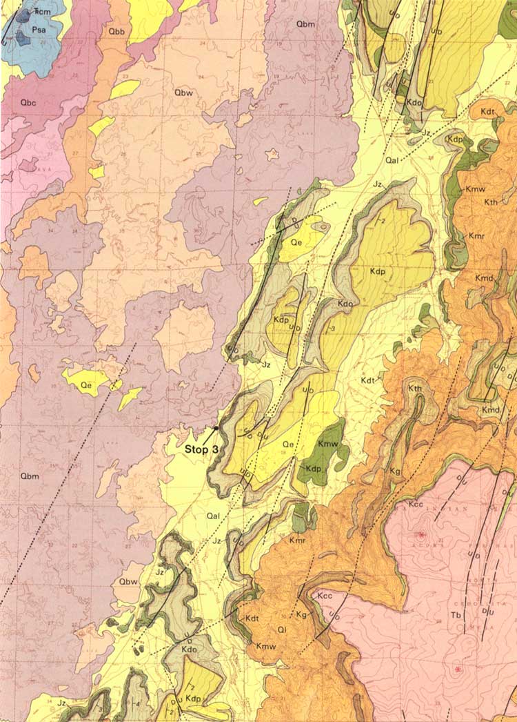
FIGURE 2.—El Tintero cinder cone is the source for
the Bluewater flow. Cinders are being quarried in this site for use as
road material. A late, stubby basalt flow from El Tintero can be seen
in the foreground.
|
The Bluewater flow is a tholeiite, very similar in
composition to the Laguna and McCartys flows (Table 1). Most samples of
the flow are holocrystalline and microporphyritic with both olivine and
plagioclase present as phenocryst phases. The groundmass is dominated by
plagioclase and clinopyroxene with minor opaque oxides and perhaps some
olivine.
TABLE 1—Representative chemical compositions of dated basalts.
|
| Bluewater | Laguna |
McCartys | Twin Craters | Bandera |
Ramah Navajo | Fence Lake | North Plains |
|
| SiO2 | 51.62 | 50.23 | 51.48 | 48.86 | 44.47 | 50.70 | 50.03 | 52.06 |
| TiO2 | 1.25 | 1.53 | 1.41 | 1.44 | 3.04 | 1.17 | 1.38 | 1.45 |
| Al2O3 | 15.13 | 14.50 | 15.18 | 14.84 | 15.22 | 15.05 | 14.92 | 15.72 |
| Fe2O3 | 11.49 | 1.82 | 11.87 | 12.48 | 4.39 | 11.66 | 12.24 | 10.95 |
| FeO | N.A. | 9.27 | N.A. | N.A. | 8.42 | N.A. | N.A. | N.A. |
| MnO | 0.16 | 0.17 | 0.16 | 0.17 | 0.15 | 0.16 | 0.17 | 0.15 |
| MgO | 7.42 | 9.45 | 8.29 | 9.15 | 9.30 | 8.34 | 9.00 | 6.34 |
| CaO | 9.30 | 8.83 | 9.11 | 8.87 | 8.80 | 9.57 | 9.16 | 9.99 |
| Na2O | 2.60 | 2.91 | 2.78 | 2.81 | 3.38 | 2.44 | 2.74 | 2.79 |
| K2O | 0.42 | 0.77 | 0.69 | 0.74 | 1.60 | 0.36 | 0.64 | 0.66 |
| P2O5 | 0.15 | 0.22 | 0.19 | 0.22 | 0.58 | 0.14 | 0.19 | 0.22 |
|
Attempts to date the Bluewater flow have been made
using three methods: conventional K-Ar, U-series, and the 3He
surface exposure dating technique. All samples used for dating were
collected near Stop 1. Convention al K-Ar dates of 5.69±0.12 and
2.23±0.24 Ma were obtained on two different samples collected by
Laughlin and Perry, respectively. Based on the degree of preservation of
this flow and its position on the present valley floor, these apparent
ages are believed to be anomalously old because of the presence of
excess 40Ar, i.e. 40Ar incorporated into minerals
from gases in the magma. Sims and Murrell (unpublished) have obtained a
well defined isochron age of 79 ka using the U-series method (Fig. 3).
Poths (Los Alamos National Laboratory) has also dated two samples from
this outcrop using the 3He surface dating method. The average
for these samples was 57±6 ka (uncertainty in production rates is
±30%). During crushing of olivine, Poths has detected large
amounts of excess 40Ar in olivine and clinopyroxene from the
Bluewater flow.

|
|
FIGURE 3—230Th/232Th versus
238U/232Th for the Bluewater flow from the
Zuni-Bandera field on the Jemez lineament in New Mexico. The isochron,
shown by the dashed line, gives a 2σ age of 79 ka+40 ka/-30
ka.
|
Continue west on NM 122.
|
| 13.1 |
Turn left on access road (NM 606) to Exit 72 on Interstate 40. |
| 13.3 |
Return to Interstate 40 and proceed east. |
| 23.8 |
Zuni Canyon flow is on the right. This flow, which originated from
the Paxton Springs volcano, is an alkaline basalt. Based upon the degree
of surface preservation, it is older than the Bandera flows and younger
than both the Bluewater and Laguna flows. Although this flow has not
been dated, there are several potential sites to look for charcoal
beneath the flow within Zuni Canyon. The small hill on the right
surrounded by lava is the Chinle Formation. It is capped and ringed by
travertine deposits of Quaternary age. |
| 27.1 |
There are high-mesa basalts to the north on the southern flank of
Mount Taylor; these range from 3.7 to 2.9 Ma (Perry et al., 1990;
Laughlin et al., 1993). We are now traveling across the Laguna flow
which has been dated at 110-128 ka (Laughlin et al., 1993). |
| 30.8 |
Exit Interstate 40 at the NM 117 interchange toward Quemado (Exit
89), cross over the interstate and proceed east on frontage road (NM
124) to the right. McCartys flow is on the left. Geomorphic features of
the McCartys flow were first described by Nichols (1946), and Carden and
Laughlin (1974) described the chemical variations along the length of
the flow. |
|
Mileage: 32.0. Stop 2: Laguna flow
Lat. 35° 04.53' N
Long. 107° 45.22' W
The Laguna flow (Qbc of Maxwell, 1986) is well
exposed in the Rio San Jose valley east of Grants (Fig. 4). According to
Maxwell, it originated from the El Calderon volcano at the southern end
of the Zuni Mountains. From its source it flowed northward around the
east side of the Zuni Mountains before it turned eastward to flow down
the Rio San Jose valley. Within the valley it is overlain in places by
the McCartys basalt. Drake et al. (1991) concluded from water-well data
that it can be traced eastward down the valley beneath alluvium to the
vicinity of the Laguna Pueblo, where it is again exposed.
|
|
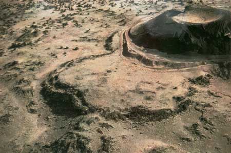
FIGURE 4—This photo shows the ~3 ka McCartys flow
overlying the older (110-128 ka) Laguna flow near the intersection of
Interstate 40 and NM 117 about 6 mi east of Grants.
|
The Laguna flow is an olivine tholeiite (Table 1). It
is typically holocrystalline, but small amounts of glass containing
opaque oxides are locally present. All thin sections show olivine
phenocrysts in a groundmass of plagioclase, clinopyroxene, olivine, and
opaque oxides. Sample 63, collected where the flow is relatively thick,
is characterized by an ophitic texture with plagioclase and
clinopyroxene, as well as olivine appearing as phenocryst phases.
Several attempts have been made to date the Laguna
flow by the conventional K-Ar method (Laughlin et al., 1979, 1993;
Lipman and Mehnert, 1979; Champion and Lanphere, 1988) with ambiguous
results. Laughlin et al. (1979) reported an apparent age of
1.57±0.26 Ma for a sample collected along Interstate 40 west of
the intersection with NM 117. Because it was believed that this age was
anomalously old, the flow was resampled at two new sites. Laughlin et
al. (1993) report ages of 0.054±050, 0.110±0.076, and
0.120±0.73 Ma for these samples (sample 63 was analyzed twice)
(Table 2). Lipman and Mehnert (1979) reported an apparent age of
0.28±0.25 Ma for the flow near Laguna Pueblo, and Champion and
Lanphere (1988) reported an apparent age of 0.128±0.033 Ma for a
sample collected by Laughlin at Stop 2.
TABLE 2—K-Ar dates on second pulse basalts in the
Zuni-Bandera volcanic field.
|
| Sample ID | Location |
Material | K2O
(%) |
40Ar
(10-12 mg/) |
40Arrd
(%) |
Age (Ma) |
|
| B-1-74 | West of Bandera Crater | Basalt | 1.32 | 0.378 | 7 | 0.199±0.042 |
| BR-2-74 | Black Rock Zuni Pueblo | Basalt | 0.48 | 0.483 | 1 | 0.70±0.55 |
| 153 | Black Rock Zuni Pueblo | Basalt | 0.59 | 0.139 | 6 | 0.164±0.035 |
| AWL-2-89 | Cerrito Arizona | Basalt | 0.98 | 0.209 | 1 | 0.148±0.087 |
| AWL-6-90 | East of El Morro | Basalt | 0.48 | 0.076 | 0.5 | 0.109±0.044 |
| AWL-10-80 | Laguna Flow | Basalt | 1.13 | 0.088 | 0.2 | 0.054+0.050 |
| 63 | Laguna Flow | Basalt | 0.84 | 0.132 | 1 | 0.110+0.076 |
|
|
| 0.85 | 0.147 | 1 | 0.120+0.073 |
|
Return to Interstate 40/NM 117 intersection and
proceed south on NM 117.
|
| 43.4 |
Turnoff to Sandstone Bluffs overlook. |
|
Mileage 45.8. STOP 3: McCartys flow at "Little Narrows"
Lat. 34° 56.01' N
Long. 107° 50.33' W
The McCartys flow is the youngest basalt flow in the
Zuni-Bandera volcanic field. Its source is a low shield volcano located
about 40 km (24.8 mi) south of the intersection of Interstate Highway 40
and NM 117. A small cinder cone about 8 m (26 ft) high sits on top of
this broad shield. Although some of the lava flowed southwestward 8 to 9
km (5 to 5.6 mi), most followed the preexisting drainage and flowed
northward about 40 km (24.8 mi) before turning eastward 10 km (6.2 mi)
down the Rio San Jose valley. The McCartys flow overlies older basalts
of the Zuni-Bandera volcanic field and Holocene alluvium.
The McCartys flow is typically a vesicular,
porphyritic basalt. Carden and Laughlin (1974) examined chemical and
petrographic variations along the length of the flow and reported that
within 4 km (2.5 mi) of the source the basalt is characterized by
plagioclase phenocrysts 0.20 to 1.5 cm in length. At greater distances
from the source, large plagioclase phenocrysts are absent and olivine
phenocrysts are present. Plagioclase is the dominant mineral in samples
of McCartys flow.
Prior to the work of Laughlin et al. (unpublished),
the age of the McCartys flow was poorly constrained. Nichols (1946)
concluded on the basis of Indian legends and archeological and faunal
evidence that the McCartys eruption probably took place after 700 A.D.
During the summer of 1992, two charcoal samples were collected from a
baked soil beneath the flow at the "Little Narrows," including burnt
roots 1-2 mm in diameter (Stop 3, Figs. 5a, b, and 6). Accelerator
mass-spectrometer radiocarbon dates of 2970±60 and 3010±70
years B.P., which yielded an average, calibrated age of 3160-3200 years
B.P., were obtained on these samples. Poths has analyzed three aliquots
of a sample of the surface of the flow using the 3He method.
An average age of 2450 years has been obtained on these samples. An
uncertainty in the production rate for 3He of ±30% may
contribute to the discrepancy with the radiocarbon dates.
|
|
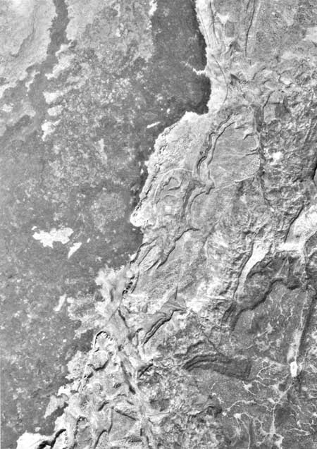
FIGURE 5a—Aerial photo of the eastern edge of
McCartys flow. Stop is near the center of the photo. (click on image
for an enlargement in a new window)
|
|
|
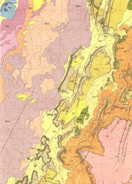
FIGURE 5b—This p ortion of the geologic map of
Maxwell (1986) covers essentially the same area as the photograph in
Fig. 5a. (click on image for an enlargement in a new
window)
|
|
|
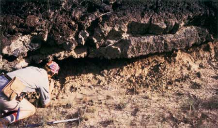
FIGURE 6.—Geologist Steven Reneau of the Los Alamos
National Laboratory is collecting charcoal for 14C dating
from the baked soil beneath McCartys flow.
|
Leave Stop 3 and return to The Inn in Grants
via NM 117 and Interstate 40. |
state/nm/1993-149/sec1.htm
Last Updated: 28-Mar-2006
|