
|
New Mexico Bureau of Mines & Mineral Resources Bulletin 149
Field-trip guide to the geochronolgy of El Malpais National Monument and the Zuni-Bandera volcanic field, New Mexico |
PREFACE
FIELD-TRIP GUIDE TO THE GEOCHRONOLOGY OF EL MALPAIS NATIONAL MONUMENT AND THE ZUNI-BANDERA VOLCANIC FIELD, NEW MEXICO
By A. WILLIAM LAUGHLIN, ROBERT W. CHARLES, KEVIN REID, and CAROL WHITE
Much of the land that you will be crossing for the next two days is owned by the Ramah Navajo, Zuni, Laguna, and Acoma tribes, or is under the jurisdiction of the U.S. National Park Service or the Bureau of Land Management. Their permits are required for sample collection.
In this field-trip guide, two abbreviations are used that may not be familiar to the non-geologist: ka represents thousands of years and Ma represents millions of years. Both abbreviations refer to the number of years before the present, which is arbitrarily taken to be 1950 A.D.
Word processing and illustrations were done by Carol White, John Tubb, Eric Montoya, and Anthony Garcia.
|
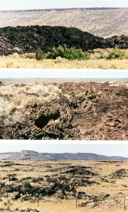
| Modification of basalt-flow surfaces with increasing age. In the top photograph, the ~3 ka McCartys flow shows essentially no modification, although grasses and small trees are growing on the flow in places. The center photograph shows the Zuni Canyon flow which is constrained in age between the Bandera flow (~11 ka) and the Bluewater flow (57 ka). Eolian soils are accumulating on the surface, particularly on areas of rough aa surfaces. The lower photograph shows the ~115 ka Laguna or El Calderon flow. Soil accumulations are relatively thick on this flow and in many places only the tops of pressure ridges protrude above the soil. |
| <<< Previous | <<< Contents >>> | Next >>> |
state/nm/1993-149/preface.htm
Last Updated: 28-Mar-2006