|
The Geologic History of the Diamond Lake Area
|
|
GEOLOGIC HISTORY OF THE DIAMOND LAKE AREA (continued)
GROWTH OF MT. THIELSEN AND MT. BAILEY
It probably was shortly after the disturbances at the close of the Miocene, and just after the initiation of volcanic activity at Pig Iron Mountain, that Mt. Bailey, Mt. Thielsen, Howlock Mountain, and the other High Cascade peaks in the Diamond Lake area began to erupt. The lavas and eruptive history of Mt. Bailey, Mt. Thielsen, and Howlock Mountain are very similar, and are representative of the other High Cascade peaks in the area. These volcanoes will be discussed in some detail, and occasional references will be made to other peaks in the Diamond Lake area.
The bulk of Mt. Thielsen, Mt. Bailey and Howlock Mountain consists of pyroxene basalt. There is a small amount of olivine in the basalt but the amount of the mineral pyroxene exceeds that of olivine in virtually all samples. Pyroxene is a mineral group containing several members. On the lower slopes of Mt. Thielsen the lavas contain mostly hypersthene pyroxene; on the upper slopes, augite is the predominant pyroxene. Changes in color and texture of the lavas on the lower and upper slopes are also noticeable. The lavas of the upper slopes are more vesicular—that is, they contain more voids, or holes—which indicates they originally contained a greater amount of gas than did the lavas of the lower slopes. Also, the lavas of the upper slopes are darker in color due to the higher content of magnetite in the glassy matrix of the lavas.
All the lavas described above were extruded over a period of 10 million years or so. As stated, the initial eruptions probably began shortly after the close of the Miocene, some 12 million years ago, and continued to erupt until about 1 million years ago. These lavas were very fluid and flowed rapidly away from the point of their extrusion, building a broad, shield-type volcano. The flows were extruded from the central vent, and probably also from fissures in the sides of the volcano. The flows making up Mt. Thielsen extended for miles away from the summit—the east-west diameter of the volcano is about 10 miles.
Within two miles due north of the summit the flows interfinger with those of Howlock Mountain. The longest flows from Mt. Thielsen and Howlock Mountain are in a northwesterly direction from their summits; flows from Mt. Thielsen extend over 7 miles in that direction.
During the approximately 10 million years Mt. Thielsen was active, hundreds of flows issued from its summit and flanks. Most of the flows exposed on the upper slopes are between 5 and 10 feet thick, and slope outward from the summit at about 5°. When its full growth was attained, the lava cone of Mt. Thielsen stood between 6,000 and 7,000 feet above the old Cascade platform which, itself, was 3,000 to 4,000 feet above sea level. Hence, Mt. Thielsen rose ultimately to a height of 10,000 or more feet above sea level.
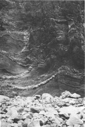
Near the end of the eruptive history of Mt. Thielsen the nature of material issuing from its summit changed. The volcano became explosive and began throwing out fragments of solid rock, cinders, and pasty clots of magma. The crater at the summit measured about 1-1/2 miles in diameter and was several hundred feet deep. This crater was filled with cindery, fragmental material which eventually overlapped the limits of the crater. The cinder cone consists of yellow, grey, and brown tuffs containing numerous angular blocks of old lava which were torn loose from the throat of the volcano at depth and blown out the vent with the fresh cinders and lava. The cinder cone itself contains many tabular sheets of igneous rock which resulted from the injection and cooling of magma in the cinder beds. As explosive forces ripped through the cinder cone, numerous fractures developed in these beds. Molten lava from depth was forced into these fractures and congealed there, forming dikes. Most of these dikes are about 6 feet wide. Some of the lava squeezed through the fractures and flowed down the flanks of the cinder cone to form thin basalt flows.
|
| Dikes in exposed cross-section of cinder beds on Mt. Thielsen. |
The explosions which built the cinder cone alternated with periods of quiet inactivity during which gas pressure mounted in the magma chamber. The magma in the conduit above the magma chamber cooled and solidified during these periods of inactivity, only to be shattered and blown out when increasing gas pressure from below overcame the solidity of the plug of frozen lava in the throat of the volcano.
During the last stages of volcanic activity the magma in the conduit of Mt. Thielsen solidified partially or completely to form a plug. The pressure from below was great enough to force this plug upward as a solid or semi-solid mass, but did not fracture it or blow it from the conduit. As the plug rose through the cinder cone it dragged the adjacent cinder beds upward so they sloped steeply away from the plug. In some places the cinder beds are so deformed that they are vertical or slightly overturned next to the plug.
Another plug developed simultaneously and is exposed about one-half mile to the east of the one just described. The cinder beds adjacent to it dip sharply, like those surrounding the main plug. The cinder cone atop Mt. Thielsen, therefore, was built around two closely spaced vents, both within the limits of the crater.
The plugs themselves consist of more-or-less vertical cylinders of dark grey to light grey lava. The outer margins of the plug are fine grained and dark colored, due to their more rapid cooling. The texture and color grade inward to a coarser grained and lighter grey lava in the central portion of the plug. This portion cooled more slowly; therefore, the crystals had time to grow larger and the gas contained in solution exsolved, producing a vesicular texture in the interior portion of the plug.
Also near the close of Mt. Thielsen's eruptive history, and perhaps even later than the building of the cinder cone at its summit, two parasitic cinder cones developed near the base of the volcano. These are located to the south and southwest of the summit, and consist of fragmental lava, cinders, and scoria. The surfaces of these cones are now heavily timbered, making exposures of the rock scarce.
|
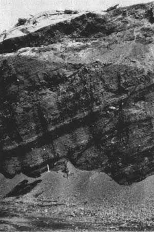
| Cinder beds exposed in rock pit on Kelsay Point. |
Summit Rock, an intrusive plug very similar to the plugs at the summit of Mt. Thielsen, lies at the base of Mt. Thielsen about 3-1/2 miles south of its crest. The dense lava making up this plug is suitable for use as road metal, and currently is quarried for that purpose. This rock is of interest to the mineral collector because it contains labradorite and pigeonite in the ground mass; also, small crystals of hematite, hypersthene, acmite, albite, apatite, cristobalite, and tridymite appear as incrustations lining small fractures and vesicles in the rock. Cristobalite and tridymite also are found in the plugs at the summit of Mt. Thielsen. The summit crater measures about a mile in diameter and contains an intrusive plug. The rock making up the plug is essentially identical to that making up the plugs on Mt. Thielsen. The diameter of the Howlock volcano is about the same as that of the Mt. Thielsen volcano, but the cone is about 1,000 feet lower. Like those of the Mt. Thielsen volcano, the longest Howlock lava flows merge with those from Mt. Thielsen along Thielsen Creek.
Several cinder cones are scattered over the slopes of Howlock Mountain. Tipsoo Peak, Red Cinder Butte, and Cinnamon Butte are the largest of these. Tipsoo Peak and Cinnamon Butte are breached cones. A portion of their flanks was blown out, giving an arcuate or crescentric form to the cones.
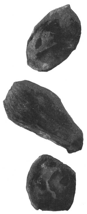
Cinnamon Butte, Kelsay Point, and other cinder cones in the Diamond Lake area are littered with volcanic bombs and fragments of bombs. These range in size from a few inches to a few feet across, and display fine grained rinds and bubbly, vesicular interiors.
|
| Volcanic bombs taken from Cinnamon Butte. |
The cinder beds at Kelsay Point have been well exposed by a quarrying operation. The beds at the summit of the cone dip northerly, indicating the vent lay somewhere to the south of the present summit. The cinder beds display well developed layering of coarser and finer fragments, and contain volcanic bombs and blocks up to several feet across. (The large, reddish bomb displayed on the porch of the Information Center at Diamond Lake was taken from the Kelsay Point cinder cone.) The variance in the size of the cinders and fragments in given layers reflects the variation in intensity of the eruptions that blasted the material from the vent.
The Mt. Bailey volcano was built contemporaneously with Mt. Thielsen and Howlock Mountain. The lava flows from Mt. Bailey and Mt. Thielsen interfinger beneath Diamond Lake. The flows from Mt. Bailey extend some 6 or 7 miles northward from its summit, and there they are overlain by the younger, glowing-avalanche deposits which obscure the contact between the Mt. Bailey lavas and the intracanyon basalt flows. To the west and northwest of Mt. Bailey the lavas overlap the older Western Cascade lavas. About 2 miles to the south of the summit of Mt. Bailey, the Bailey lava flows merge with those of Twin Knobs and Sherwood Butte. These hills form a portion of a deeply dissected, basaltic lava cone. The flows making up Mt. Bailey are very similar to those making up Mt. Thielsen in that the later lavas are darker in color and more vesicular than the earlier flows. Mt. Bailey also is capped by a cinder cone, though it is much smaller than the one capping Mt. Thielsen. The cinder cone atop Mt. Bailey neither contains dikes, which are numerous in the Mt. Thielsen cone, nor does it contain a central plug, of which Mt. Thielsen has two. At the south end of the main ridge crest leading to Mt. Bailey's summit is a small, subsidiary crater. The crater is well preserved, and evidently was formed near the cessation of volcanic activity. From the lip of the crater to its bottom is a vertical distance of 50 to 100 feet. The crater apparently contains some snow the year round.
When the Bailey volcano had attained its full height, it stood perhaps 1,000 or 2,000 feet lower than Mt. Thielsen. Like Mt. Thielsen, Mt. Bailey grew over a period of several million years and became inactive about one million years ago.
|
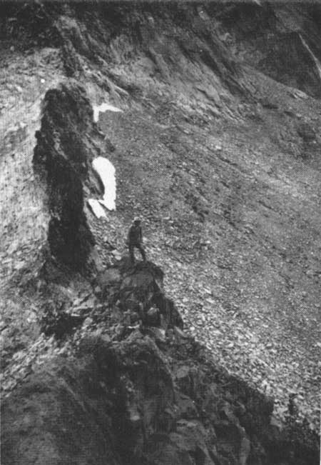
| Arête divides two glacial cirques high on slopes of Mt. Thielsen. |
About 3 miles down the north slope of Mt. Bailey are two parasitic cinder cones. The larger of these, Rodley Butte, has the typical crescentric shape of a breached cinder cone. Two and one-half miles southeast of the summit, near the base of Mt. Bailey, lies Hemlock Butte—a parasitic lava cone. The material extruded at this point was fluid, rather than fragmental, and resulted in a small volcano perched on the lower slopes of Mt. Bailey.
Kelsay Mountain is another High Cascade volcano that grew in the Diamond Lake area during the Pliocene Period. Numerous cinder cones also grew during this period, and these include Red Cinder Butte, Thirsty Point, Tenas Peak, and Windigo Butte.
| <<< Previous | <<< Contents>>> | Next >>> |
diamond_lake_geology/sec3a.htm
Last Updated: 01-Jul-2008