
|
Geological Survey 8th Annual Report (Part I)
Geology of the Lassen Peak District |
GEOLOGY.
(continued)
STRUCTURE OF THE SIERRAS.
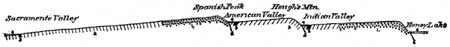
That the development of the Sierras and their relation to the volcanic ridge of Lassen Peak may be more readily understood, some of the more salient structural features of the northern portion of the range will be briefly considered. It has a width of about eighty miles, extending from the Sacramento Valley to Honey Lake, and has three distinct crests which are characterized by long, gentle slopes to the southwest, and short, abrupt ones in the opposite direction, as shown in Fig. 19. The western crest, to which Claremont Hill and Spanish Peak belong, is near the middle of the range, and attains an altitude of about seven thousand feet. From this point the long, gentle slope extends to the Sacramento Valley, at an elevation of less than three hundred feet above the sea. It is more or less undulating and deeply cañoned by numerous streams. From Claremont Hill the slope is abrupt towards American Valley, which at Quincy has an altitude of 3,375 feet. Continuing to the eastward the slope again rises more gently 7,300 feet to the middle crest, in which Hough's Mountain is a prominent feature, and then descends steeply, as in Pl. LI, to Indian Valley, at an elevation of about thirty-five hundred feet. Farther on the topography is irregular, but becomes an even slope, rising to 6,000 feet in the summit of the eastern crest, the bold escarpment overlooking Honey Lake. The outline of the Sierra Nevada Range, as seen in cross-section, is such as to at once suggest that, like the basin province, it is composed of tilted orographic blocks, which are separated from one another by faults. The fact that Indian Valley and American Valley, which are the depressions between the crests of the range, were occupied by lakes during the Quaternary or later times greatly heightens the analogy.1
1For remarks upon the stratigraphy of the orographic blocks, see Bull. U. S. Geol. Survey, No. 33, pp. 12-15.
|
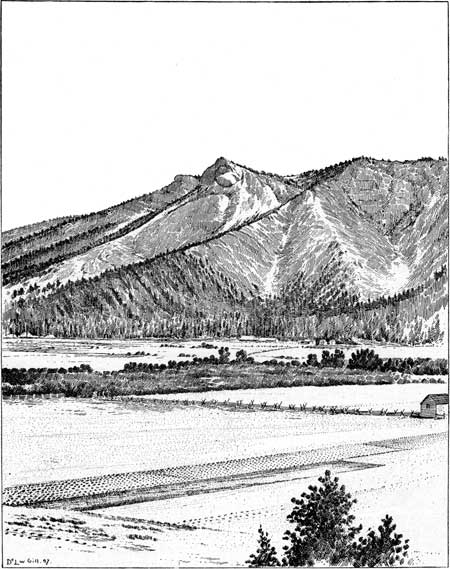
| PLATE LI.—HOUGH PEAK, LOOKING SOUTH ACROSS THE WESTERN PORTION OF INDIAN VALLEY. |
|
| FIG. 19. Section from Honey Lake to Sacramento Valley. 1. Granite. 2. Auriferous slates. 3. Carboniferous limestone. 4, Quaternary, or recent deposits. 5. Faults. |
The recurrence of the same fossiliferous strata in a cross-section of the Sierra Nevada Range in exactly analogous topographic and stratigraphic positions confirms the hypothesis suggested by the profile that the northern end of the Sierra Nevada Range is made up of three orographic blocks separated from one another and from those of the Great Basin by profound faults, and shows that the basin range structure extends as far west as the Sacramento Valley. Mr. G. K. Gilbert2 several years ago pointed out the characteristic features in the structure of the Sierra Nevada Range. Prof. Joseph Le Conte3 had previously called attention to a profound fault along its eastern base in the vicinity of Owen's Lake, and has since published a most interesting contribution4 on a post-Tertiary elevation of the Sierra Nevada shown by the river beds.
2Science, vol. 1, 1883, p. 195.
3Am. Jour. Sci., 3d series, vol. 16, 1878, p. 101.
4Ibid., vol. 32, 1886, p. 167.
By far the greater portion of the range appears to be formed of one great orographic block, which is continuous with the western block of the range at its northern termination. Its long, gentle slope westward is expressed in the drainage lines, and its eastern crest is the divide between the Great Basin and the Pacific. Almost throughout its whole extent the Sierra Nevada faults of greatest dimensions are impassable to important streams except at the northern end of the range, where the number of fault blocks is increased. The forks of Feather River cross two of the prominent lines of displacement. These streams, like nearly all those that flow down the western slope, are in deep cañons. That of the North Fork of Feather River, where it crosses the western fault, has a depth of 4,000 feet, affording an excellent section of the folded strata, and its terraces indicate the character of the uplifting in forming the mountain range.
Structurally the Sierra is like the Great Basin range, differing chiefly in the magnitude and the present elevation of the blocks. Like the orographic blocks of the Great Basin area, they are composed of plicated strata, the folding of which, as has been pointed out by a number of observers, took place long before the faulting that gave birth to the peculiar features of the range. It is important to remember the fact that at the time the strata of which the Sierra is composed were folded (i. e., about the limits between the Jurassic and Cretaceous periods) the range was not differentiated from the continental mass of the Great Basin region, and it was not until a very much later period that this separation occurred.
It must not be imagined that the structure of the Sierra is really as simple as it appears in Fig. 19; for, as already stated, the auriferous slates and numerous eruptive masses of which the orographic blocks are composed are not only folded in a very confusing manner, but are greatly complicated also by a large number of recent faults. The uplifting of the Sierras resulted in the increased declivity of their western slope and caused the streams more and more vigorously to corrade their beds. Each successive uplift increased the corrasion and restricted the stream to a narrower channel, leaving terraces upon the slopes of the cañon to mark the time of the uplifting. Thus it happens that the western slope, once gentle and flooded by Pliocene streams, is now deeply furrowed by terraced cañons.
RELATION OF THE UPLIFTING AND FAULTING OF THE
SIERRAS TO EACH OTHER AND TO VOLCANIC PHENOMENA.
The relation of the uplifting of the Sierra Nevada Range to its volcanic activity and faulting is one of the most important problems that the district affords, and its solution can not be fully attained until the detailed survey of districts adjacent to that of Lassen Peak is complete. During the whole of the Cretaceous and the Tertiary the great belt of country lying east of the present Sacramento Valley embracing the region now occupied by the Sierra, and a large portion of the Great Basin, was above the sea, and subjected to great degradation, which reduced it almost to its base level of erosion. This gentle plain swept westward toward the ocean directly across the site of the present Sierra. That the north end of the Sierra country was a lowland during the Miocene, as already shown, is rendered perfectly evident by the character of its flora; and the relation of the Miocene conglomerate to the eastern escarpment north of Honey Lake is such as to demonstrate that during the Miocene the Sierras were not yet in existence. Similar conditions continued through the Pliocene, for the Pliocene gravels on the western slope of the Sierras were evidently deposited while its inclination was very gentle, before the Sierra region had attained any considerable elevation, and apparently also while it was yet a part of the Great Basin platform. The long continued repose of that region was terminated by the development of vigorous volcanic activity, accompanied by extensive upheaval. That these two phenomena developed contemporaneously is made plain by the relations of the volcanic products to the Pliocene and Quaternary river channels. It is well known that the Pliocene channels were filled with volcanic débris and lava flows to such an extent that the streams had to seek new channels. The differential uplifting which accompanied the volcanic outbursts greatly increased the erosive power of the streams, and the result is to be seen in the deep cañons which they have cut down the western slope of the Sierras, leaving the ancient beds of the Pliocene streams on the divides far above the present water ways. That the uplifting of the Sierras was not all accomplished at once but by a succession of upheavals separated by considerable intervals of time is evidenced by the traces of stream terraces which can be detected along the slopes of the cañons. These have the same origin as that already considered in describing the Piedmont region (page 426), and are undoubtedly due to successive increase in the declivity of the western slope produced by differential elevation. Now, it not infrequently happens that the lava erupted at the time of the uplifting has flowed down a cañon and capped the terrace formed at that time. That the terrace is due, not to the lava flow, but to the upheaval, is readily perceived by following the flow to its lower extremity, where the terrace upon which the lava rests will be found to continue far beyond the lava stream itself. While it can not be demonstrated that each volcanic eruption was accompanied by a corresponding elevation, it appears to be generally true that each great upheaval was accompanied by volcanic outbursts. Numerous examples of the contemporaneity of upheavals and volcanic effusion indicate that they may be casually connected.
The faulting by means of which the Sierra Nevada Range was separated from the Great Basin platform took place, in a geologic sense, very recently. The eastern escarpment of the range, at least in its northern portion, was evidently formed after the conclusion of the volcanic activity in its immediate vicinity. Attention has already been called to the displacement of very recent lavas along the crest north of Honey Lake. Opposite Janesville, on the very brow of the eastern escarpment, is Thompson Peak, which is half of a crater cone cut in two by the fault; the other half has fallen away. The bedded tufas of the elevated remnant of the cone are a very conspicuous topographical feature on the crest, and their relation to the displacement is unmistakable. Thompson Peak was an active volcano during a very late geologic epoch, so recent indeed that notwithstanding its destructibility and exposure it has suffered comparatively little from erosion. Farther northward along the same crest other new basaltic flows have been profoundly dislocated in the same manner. The great mass of gravel which forms a smooth, barren ridge on the crest southeast of Diamond Peak was evidently formed before the faulting occurred. Its upper portion is composed chiefly of pebbles of modern lavas, indicating clearly that the volcanic activity antedated the dislocation. I have searched in vain along the eastern escarpment north of Honey Lake for volcanic material the eruption of which succeeded the faulting.1
1In the vicinity of Lake Mono, however, and perhaps also at other points along the eastern base of the Sierras, there has been very recent volcanic activity, apparently subsequent to the displacement.
The great fault which lies along the western side of American Valley continues northwesterly with irregularities into the modern lavas about the head of Butte Creek. At a number of other points north and east of Big Meadows there are lines of dislocation parallel with those of the Sierras and probably formed at the same time. They intersect some of the latest lava flows of that region and were evidently developed long after the volcanic activity had passed its maximum. Not a single example has been found of the escape of lava through a fault fissure.
This subject will be more fully discussed at another time, while considering in detail the volcanic phenomena of the Lassen Peak district. Enough has been said to make it evident that the volcanic activity upon the northern end of the Sierras occurred at the time of their upheaval and that the faulting and subsidence of the Great Basin region which individualized the range took place at a later date.
| <<< Previous | <<< Contents >>> | Next >>> |
rpt/8-1/sec2d.htm
Last Updated: 28-Nov-2006