
|
Geological Survey 8th Annual Report (Part I)
Geology of the Lassen Peak District |
GEOLOGY.
(continued)
GEOLOGIC FORMATIONS IN THE LASSEN PEAK
DISTRICT.
(continued)
CRETACEOUS—CHICO BEDS.
Composition—The Chico-Tejon series is composed chiefly of soft, yellowish olive sandstone, but frequently also considerable masses of conglomerates and shales occur. The sediments of which they are composed were evidently derived directly from the auriferous slates upon which they repose uncomformably. Fragments of volcanic rocks are indeed not uncommon among the pebbles of the Chico conglomerates, but they are usually much altered and quite unlike the modern lavas of the Lassen Peak district.
Distribution.—The Chico-Tejon series has a wide distribution throughout the great central valley of California, and outcrops at many places along the foothills upon both sides. The lower member of the formation reaches the very northern limit of the valley and extends eastward through the Lassen Peak district, beneath modern lavas, far into Oregon. Formerly it was completely covered by later stratified deposits, but at a number of places in the Piedmont region these have been removed and the strata of the Chico group again brought to light.
In the cañon of Chico Creek, between eleven and sixteen miles east of the village of Chico, the yellowish olive Cretaceous sandstone is well exposed for several hundred feet. It has yielded at this locality a few fossils, which were identified by Dr. C. A. White. They are noted in the list of fossils, p. 410.1 These fossiliferous sandstones dip westerly about 6 degrees, while the inclination of the overlying stratified tufas is considerably less. As the declivity of the stream is not so great as that of the Cretaceous sandstone, they disappear beneath its bed before reaching the limit of the Piedmont region. At its eastern border the Cretaceous sandstone attains an elevation of about one thousand eight hundred feet above sea level, and rests unconformably upon the contorted auriferous slates.
1Most of these fossils are unlike the ones collected by Professor Whitney at the same locality. (Geol. Survey California, Geology, vol. 1, 1865, p. 209.)
Similar strata have been observed in the cañons of Deer and Mill Creeks, but no fossils were seen by the writer at either of these localities. Fossils have been reported, however, in these cañons, and also in that of Antelope Creek, by the late Professor Gans, of Red Bluff, but their exposures could not be found within the time at my disposal. At the Tuscan Springs, six miles east of Red Bluff, and just outside of the western border of the map, there is an exposure of the Cretaceous rocks which has yielded Professor Whitney an abundance of fossils.2
2Ibid., p. 207.
Proceeding northward, the next locality for Cretaceous fossils is in the dry bed of a small stream near the eastern base of a prominent cinder cone in Shasta County, about six miles southwest of Shingletown. The exposure is a very small one, laid bare by the removal of the superincumbent tufas. Numerous fossils are said to have been collected at an outcrop south of Darr's saw mill and at the falls in the South Fork of Bear Creek, but the limits of the exposure have not been traced.
Upon the North Fork of Bear Creek and the South Fork of Cow Creek is a large tract of Cretaceous characterized by its organic remains. These two streams are separated by a prominent ridge which is perhaps generally known in that vicinity as Bear Creek Hill. It is capped by a remarkably interesting flow of streaked lava lying upon volcanic and other sediments, which in turn are underlaid by the Cretaceous. Near the northern base of this ridge the fossiliferous sandstone dips at an unusually high angle (12°) southeasterly beneath the hill in such a way as to suggest that the hill originated in part by dislocation. At an elevation of 1,600 feet, near the western end of this ridge, in a gulch opening into the South Fork of Cow Creek, a few fossils were collected.1 Prominent among them is Baculites chicoensis. At Coal Gulch, upon the North Fork of Cow Creek, traces of coal have been found and prospected unsuccessfully in the Chico group. A short distance farther north, on the South Fork of Clover Creek, the fine, shaly beds of the same formation contain a number of fossils.2 At this point the Cretaceous is found resting directly upon the contorted and highly metamorphosed auriferous slates. In the same neighborhood, one-half a mile south of the falls in the North Fork of Clover Creek, a large number of specimens of an interesting fossil oyster were found. It occurs at an elevation of 1,300 feet and forms a veritable shell heap, filling a small depression in the metamorphic rocks by which it is completely surrounded, although within a few yards of the border of the characteristic fossiliferous Cretaceous sandstone. There can be no doubt that this fossil oyster belongs to the Chico group, and as it is new, a brief description of it by Dr. White is given below.3
1Lot number 2 in the list, p. 410.
2Lot numbered 4, p. 410.
3Ostreae (Alectryonia) Dilleri White.—Shell sub-elliptical in marginal outline, the irregularity of which is increased by a more or less prominent posterior wing; both valves more of less convex, but the lower one more capacious than the other; muscular impression large, and situated in the postero-dorsal region. Surface marked by numerous strong radiating ribs, which give the free margin a strongly dentate character. (See Bull. U. S. Geol. Survey, No. 50, Pls. 1 and 2.)
A few miles beyond the western limit of the map, between the north fork of Cow Creek and Clover Creek, at Basin Hollow, is an interesting and very instructive exposure of the Cretaceous rocks, where over two hundred and fifty feet of them may be examined. They are composed chiefly of fine shales, but there are prominent ledges of sandstone and conglomerate also. One bed of the latter is nearly twenty feet in thickness and contains some pebbles which are at least four inches in diameter. Chico fossils1 are found abundantly both above and below as well as within the conglomerate. The fine shaly beds during the rainy season give rise to the peculiarly adhesive and never-to-be-forgotten mud which is known throughout the West as adobe. The adobe land upon the northeastern border of the Sacramento Valley is all confined to the outcrop of the rocks of the Chico group, and a knowledge of this fact is of great service in tracing its outlines.
1Lot No. 3, p. 410.
On Little Cow Creek, where it is crossed by the Oak Run road, there is a fine exposure of fifty feet of Chico conglomerate, containing near its base numerous fossils.2 Its unconformable contact with the auriferous slates is very well exposed. Overlying the conglomerate is a mass of fine sandstones and shales, which, according to Mr. Luppe Eiler, who has thoroughly prospected the country, occasionally contains thin seams of coal. At one locality it is said about five tons of coal were mined before the supply was exhausted, but the quality of the coal did not prove satisfactory. From Little Cow Creek the Chico group forms a belt skirting the auriferous slates northeasterly, then northerly beyond the Pit River. It is a near-shore deposit all the way, abutting directly against and resting unconformably upon the auriferous slates from which it was derived. The latter extend far northwestwardly into the Coast Range. The actual presence of the unaltered Cretaceous rocks along this belt is demonstrated by a number of fossils, including the genera Ammonites and Inoceramus found at Kosks Creek, in the great bend of Pit River.
2Lot No. 6, p. 410.
Age of the fossils.—As already stated, a large number of fossils were collected from the series of rocks now under consideration. They were studied by Dr. C. A. White, whose list of identified forms from each locality is given in the following table. Concerning the fossils as a whole, he says that "they all belong to the Chico group, i. e., the lower or Cretaceous member of the Chico-Tejon series. None of the forms suggests the presence of the Horsetown beds below or the Tejon member of the series above."
List of identified forms.
|
No. 1. Cañon of Chico creek, 15 miles east of Chico.
No. 2. Gulch on south side of South Fork of Cow Creek; elevation 1,600 feet.
No. 3. West end of Basin Hollow near Blodget's.
No. 4. South Fork of Clover Creek; elevation about 1,400 feet.
|
No. 5. One-half mile south of Clover Creek Falls.
No. 6. Little Cow Creek, one-fourth mile below Oak Run Road Crossing.
No. 7. Little Cow Creek, 2 miles east of Woodman's, 20 miles east of Redding.
No. 8. Little Cow Creek, near Joseph Yanks, 16 miles east of Redding.
Species common to several localities:
| ||||||||||||||||||||||||||||||||||||||||||||||||||||||||||||||||||||||||||||||||||||||||||||||||||||||||||||||||||||||||
Upper and lower limits.—The Chico rocks are chiefly soft, friable, yellowish-olive sandstones, which continue to occupy almost the same position as that in which they were originally laid down, excepting perhaps the exposures at Tuscan Springs, and at the northern base of Bear Creek Hill. Since their deposition, although they have been subjected to very moderate differential uplifting, they have not experienced the slightest metamorphic changes, and remain entirely unaltered. On the other hand, the auriferous slates upon which they have been found at a number of places to discordantly repose were greatly metamorphosed before the beginning of the Chico epoch. The interval between the time when the auriferous slates assumed their present structure and position and the beginning of the Chico epoch may have been a very long one, but it has no representative among the formations of the Lassen Peak district. The lower limit of the Chico group is clearly defined, but the upper limit in the same district is not easily determined. Messrs. White and Becker1 have shown that in the southern portion of the great valley of California the Chico-Tejon series is very extensively developed, attaining the enormous thickness of 10,000 feet. Its maximum thickness in the middle of the northern portion of the Sacramento Valley is as yet unknown, but the greatest observed is only a few hundred feet. It must be remembered, however, that the only portion of the series now exposed is its edge, much attenuated upon the borders of the great depression (Sacramento Valley) which it fills. The presence of the lower member of the Chico-Tejon series in the Lassen Peak district is a matter beyond question, and the absence of the upper member can hardly be doubted. This state of affairs brings the Miocene into the place of the Tejon, a condition which was not fully recognized until the fossils were determined. This subject will be adverted to again when considering the Miocene.
1Bull. U. S. Geol. Survey, Nos. 15, 19, 1885.
GEOGRAPHY OF THE DISTRICT DURING THE CHICO EPOCH.
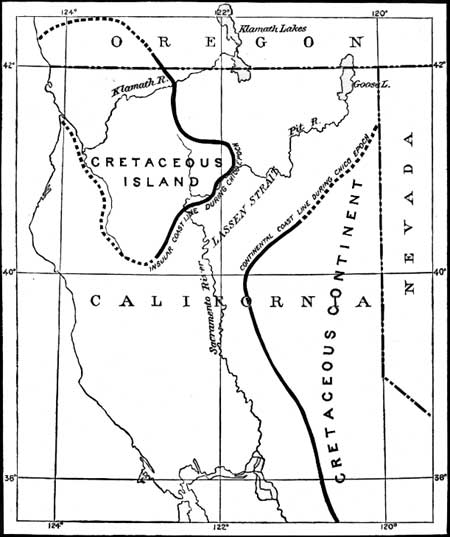
The geography of northern California during the Chico epoch is outlined upon the accompanying sketch (Fig. 15). Attention has already been called to the fact that the Chico beds at the northeastern extremity of the Sacramento Valley, in the vicinity of Pit River, are near-shore deposits. The shore line can be traced from this point westward and southwestward along that part of the Coast Range which bounds the northern extremity of the Sacramento Valley. To the northward the littoral deposits appear along the western border of Shasta Valley, in the vicinity of Yreka, and may be traced directly into Oregon. It is evident that these shore deposits were derived from an insular area of the auriferous slates which now form the prominent mountains of northwestern California and the adjacent portion of Oregon.
|
| FIG. 15. Geography of Northern California during the Chico epoch. |
Near Pence's ranch, twelve miles north of Oroville, there are interesting exposures of Chico rocks which rest directly and discordantly upon the auriferous slates. They rise in the foothills of the Sierras to an elevation of about one thousand feet above sea level, but do not reach Cherokee flat. At that place strata younger than the Cretaceous rocks of the neighborhood repose immediately upon the metamorphics. In the cañon of Chico Creek, where the Chico beds were next examined, they rise upon the western slopes of the auriferous series to an elevation of about eighteen hundred feet, and, as at Pence's, dip slightly to the westward away from the old shore line along the western border of the sierra platform. From this point northerly the littoral deposits are covered up by the extensive effusions of lava from the volcanoes in the Lassen Peak district, but there can be no doubt that the ancient coast extended northeasterly around the northern end of what is now the Sierra Nevada range towards the headwaters of Pit River, and that during the Chico epoch the Lassen Peak district lay almost wholly within Lassen Strait, which separated the island of northwestern California from the continental land to which the Sierra country belonged.
| <<< Previous | <<< Contents >>> | Next >>> |
rpt/8-1/sec2a.htm
Last Updated: 28-Nov-2006