
|
Geological Survey Professional Paper 754—C
The Portage Lake Volcanics (Middle Keweenawan) on Isle Royale, Michigan |
CORRELATIONS
The Keweenawan volcanic rocks on Isle Royale have long been thought to be correlative with those on the Keweenaw Peninsula, the Portage Lake Volcanics. But all the Keweenawan volcanic rocks exposed around the Lake Superior basin have at one time or another been thought to be more or less correlative. Only on Isle Royale and the Keweenaw Peninsula, however, is the upper part of the total Keweenawan volcanic sequence both present and in contact with overlying younger formations. At other places around the basin (fig. 1), the basal part of the volcanic sequence is present, including the volcanic rocks of the so-called South Trap Range in westernmost Michigan and Wisconsin, the North Shore Volcanic Group of Green (1971) in Minnesota, and the Osler Group in Ontario. The correlation problem for Isle Royale is thus twofold: (1) to provide a detailed correlation of the volcanic sequence on Isle Royale with the highly similar sequence on the Keweenaw Peninsula and (2) to determine possible overlap between the section on Isle Royale and the lower sequences, particularly the North Shore Volcanic Group.
CORRELATION BETWEEN ISLE ROYALE AND THE KEWEENAW PENINSULA
One of Alfred C. Lane's major contributions to Keweenawan geology was his recognition of the correlation of specific rock units on Isle Royale with their counterparts on the peninsula. In fact, he was not only the first but the only geologist to personally make detailed studies on both Isle Royale and the peninsula.
The key to the correlation is the Greenstone Flow, for as Lane (1911, p. 22) stated, "the backbone of Isle Royale and that of Keweenaw Point is the same lava flow." In each place the Greenstone is the thickest, most persistent flow and is further distinguished by its magmatic differentiation. Henry Cornwall, who studied the Greenstone Flow on the peninsula in great detail and briefly examined the flow on Isle Royale, confirmed their similarities and pointed out that although a few other flows on the peninsula show evidence of differentiation, they differ from the Greenstone Flow in other respects (oral commun., 1971).
Even more convincing than mere similarities between the "backbone" of Isle Royale and that of the Keweenaw Peninsula, however, are the similarities in the entire rock sequence in the two areas, including the position of the Greenstone Flow within the sequence. It was Lane's recognition of these broader similarities that strengthened his arguments for correlation.
Very thick flows like the Greenstone Flow are the exception, however, for while it does specifically correlate across Lake Superior, to suggest that all the flows in the Portage Lake Volcanics are continuous across the lake would be unrealistic. But different rock types were produced at different times during the volcanic cycle, and both Isle Royale and the Keweenaw Peninsula show parallel sequences of similar types, the part of the sequence above the Greenstone Flow providing the clearest correspondence.
The flows above the type Greenstone Flow on the Keweenaw Peninsula were previously divided into two groups, the Ashbed Group of Irving (1883) and the overlying Eagle River Group of Lane and Seaman (1907), both of which Lane thought he recognized on Isle Royale. On the island the Ashbed Group would include the rocks from the top of the Greenstone Flow to the top of the Scoville Point Flow, and the Eagle River Group, those from the top of the Scoville Point Flow to the top of the Portage Lake Volcanics. Although these formal group names are no longer generally used, they were applied to sections on the peninsula almost directly across from Isle Royale and are still useful for purposes of discussion.
Correlation criteria for the Ashbed Group are as follows:
1. At the base of the Ashbed Group just above the Greenstone Flow on the peninsula is the Mesnard Epidote of Lane and Seaman (1907, p. 680), described as a "volcanic ash" by Lane (1911, p. 37, 688). The tuff-breccia immediately above the Greenstone Flow on the island is in the same stratigraphic position.
2. The Washington Island Flow is unique in appearance on the island and has its counterpart in the Pewabic Flow in the same relative position on the peninsula (Lane, 1911, p. 689; Cornwall, oral commun., 1971).
3. The Ashbed Group "is characterized by lavas which contain more soda than the regular ophites and which are relatively feldspathic and fine grained [porphyrites and glomeroporphyrites]" (Lane, 1911, p. 35). These flows occur in three distinct zones in the Ashbed Group on the Keweenaw Peninsula (for example, see Davidson and others, 1955), and the middle zone contains the type Ashbed Flow. The three zones are represented on Isle Royale by the Tobin Harbor, Middle Point, and Scoville Point Flows. In fact, at least part of the Middle Point Flow of this report was specifically correlated with the Ashbed Flow by Lane (1911, p. 670).
4. On the Keweenaw Peninsula "columnar basalt occurs only in two flows, the Greenstone and a 'melaphyre' just above the Ashbed Flow" (Cornwall, 1954b). As noted earlier, on the island the Greenstone Flow is interpreted as having a columnar-jointed zone, and the columnar-jointed Edwards Island Flow appears to be in the same stratigraphic position as the "melaphyre." The other columnar-jointed flow on the island, the Long Island Flow, which lies between the Tobin Harbor and Middle Point Flows, is in the same stratigraphic position as some fine-grained melaphyres on the peninsula. Columnar jointing can be seen in only a few of the outcrops of the Long Island Flow, however, and it is possible that similar but concealed jointing occurs in the probable equivalent rocks on the peninsula, where they are largely known only from drill core.
The uppermost group, the Eagle River Group of Lane and Seaman (1907), has been described on the Keweenaw Peninsula as "characterized by waning volcanic activity. It contains numerous sandstones and conglomerates, and on the whole they are more rounded in this group than in others. The individual lava flows are generally not thick nor coarse grained" (Lane, 1911, p. 37). The rocks are also generally ophitic. This description also accurately fits the upper part of the Portage Lake Volcanics on Isle Royale, that part above the Scoville Point Flow (fig. 17).
Below the Greenstone Flow it is more difficult to make specific correlations of volcanic units. On both sides of the Lake Superior syncline, flows of the lower part of the Portage Lake Volcanics are chiefly ophitic, including a number with above-average thickness. The thick Hill Point Flow on the island could well be correlative with a thick ophitic flow such as the Scales Creek Flow (fig. 3) on the peninsula, as suggested indirectly by Lane (1911, p. 739), but such a correlation is only one of several options. Equivalents of the other stratigraphic markers on the island have not been recognized on the peninsula.
Several bodies of felsite occur in the lower part of the Portage Lake Volcanics near the east end of the Keweenaw Peninsula, at and below the horizon of the Bohemia Conglomerate (fig. 3). This would be in the upper part of the Bohemian Range Group of the older terminology. The body at Bare Hill, for example, is a fine-grained reddish-brown rhyolite that contains scattered feldspar phenocrysts as much as 2 millimeters long and is considered to be an extrusive dome (Cornwall, 1954c). A felsite reported to be lithologically similar to that of Bare Hill was intersected at the very bottom of a hole drilled at the north shoreline of Isle Royale (Lane, 1911, p. 755); projection of the felsite would reach the surface of Lake Superior about 1-3/4 miles offshore. This felsite, together with some thick felsite-pebble conglomerates above it, led Lane to suggest that its correlative stratigraphic position on the peninsula might lie within the upper part of the Bohemian Range Group at the approximate horizon of the Bohemia Conglomerate (Lane, 1911, p. 749).
Correlation of the Greenstone Flow on opposite sides of Lake Superior, or at least correlation of its relative position in the stratigraphic sequence, is also supported by paleomagnetic evidence. Books (1972) determined paleomagnetic field orientations for a cross section of the Portage Lake Volcanics near Calumet on the Keweenaw Peninsula. He found that the field directions are fairly uniform throughout the sequence, except for an anomalous variation that occurs just below the Greenstone Flow. He found an identical field variation just below the Greenstone Flow on Isle Royale.
The clastic deposits within the Portage Lake Volcanics are chiefly stream deposits laid down on top of what were essentially flat-lying lava flows within the volcanic sequence. Although these conglomerates and sandstones are lenticular rather than continuous sheets, their horizons can be carried across many of the gaps in their continuity. In places where the beds are missing, their horizons generally can be recognized in drill core by detrital material in the underlying amygdaloidal flow top, and as a result, the sedimentary units provide excellent horizon markers within the Portage Lake Volcanics where subsurface data are available (White, 1968).
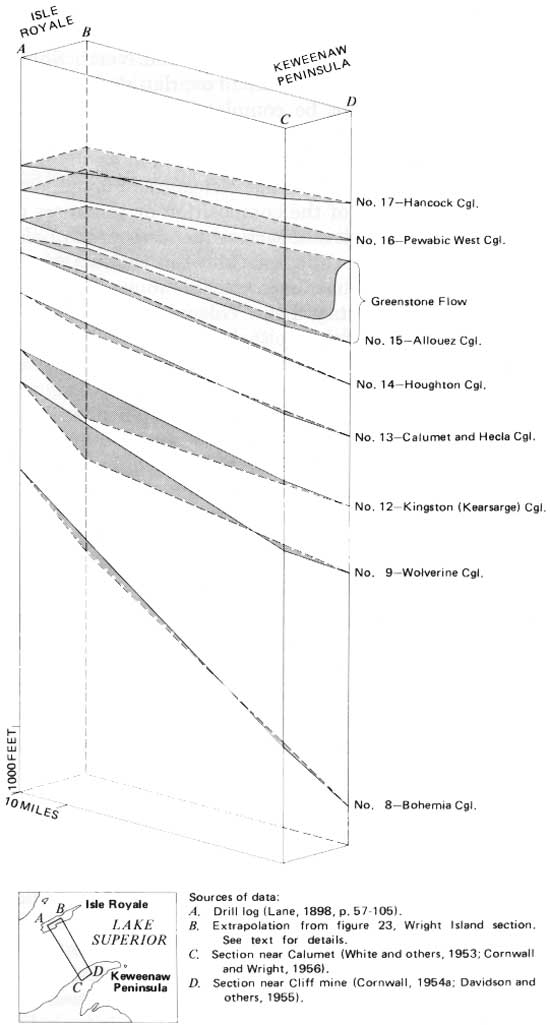
If the period of volcanic quiescence during which the sedimentary rocks were deposited was basin wide, then coeval, if not connected, sedimentary deposits might exist on opposite sides of the basin, even though differences in source areas might create dissimilarities in the deposits. On this assumption, Lane attempted to correlate individual sedimentary units on Isle Royale with the well-established sequence on the peninsula, utilizing both the nature and relative position of the sedimentary units and the nature of the intervening lava flows. In view of the general lack of outcrop of the sedimentary rocks, the attempt itself would not have been possible without the data from the series of exploratory holes drilled across the island.
If Lane's correlations are accepted (table 2), which is not unreasonable, they can be used to compare relative thicknesses of groups of flows on Isle Royale and the Keweenaw Peninsula, as in figure 24. For Isle Royale, one stratigraphic section (A) was obtained directly from Lane's drill log. By using key volcanic units as control, another section (B) was obtained from extrapolating the relative position of the sedimentary units in the drill core to the stratigraphic section near Wright Island (fig. 23). The stratigraphic diagram disregards structural considerations and the probability that the formation is thickest in the central part of the Lake Superior basin and thins in both directions toward Isle Royale and the peninsula; thus the "planes" in the illustration are very artificial and are used only to tie the individual stratigraphic sections together.
TABLE 2.—Correlation of clastic units in the Portage Lake Volcanics between the Keweenaw Peninsula and Isle Royale
|
Keweenaw Peninsula (For strat. section, see fig. 3) |
Isle Royale1 |
| Hancock Conglomerate (No. 17). | Conglomerate between Edwards Island and Middle Point Flows. |
| Pewabic West Conglomerate (No. 16). | Sandstone between Long Island and Tobin Harbor Flows. |
| Mesnard Epidote of Lane. and Seaman (1907). | Tuff-breccia above Greenstone Flow. |
| Allouez Conglomerate (No. 15). | Conglomerate at base of Green stone Flow. |
| Houghton Conglomerate (No. 14). | Conglomerate 200 ft below base of Greenstone Flow. |
| Calumet and Hecla Conglomerate (No. 13). | Very thin sandstone bed 875 ft below base of Greenstone Flow. |
| Kingston Conglomerate (No. 12) (=Kearsarge Conglomerate of Lane). | Tuff-breccia above Minong Flow. |
| Wolverine Sandstone (No. 9). | Very thin sandstone bed 350 ft below base of Minong Flow. |
| Bohemia Conglomerate (No. 8). | Series of conglomerates beginning about 450 ft below Hill Point Flow. |
1On Isle Royale only the two indicated tuff-breccias are known from outcrop. correlation of clastic units between Keweenaw Peninsula and the Isle Royale drill records is by Lane (1898); correlation of named lava flows on Isle Royale with Lane's drill log is by Huber (this report).
|
| FIGURE 24—Stratigraphic diagram illustrating correlation of sedimentary horizons in the Portage Lake Volcanics between Isle Royale and the Keweenaw Peninsula. Numbers and names are those used on the peninsula. (See fig. 3.) |
The thickness of the upper part of the sequence is somewhat similar on both sides of Lake Superior, but the lower part becomes increasingly thicker on the peninsula than on Isle Royale. This difference in the lower part would suggest that the measured stratigraphic sections on the peninsula were perhaps closer to the axis of the subsiding depositional basin than the sections on Isle Royale (fig. 1). Such an interpretation is supported by geophysical evidence (for example, White, 1966b; Wold and Ostenso, 1966).
The thickest equivalent sections on Isle Royale and the peninsula occur where the distance between the two belts of the Portage Lake Volcanics on opposite sides of the basin is the least—near the central part of the island and near the Cliff mine on the peninsula (B—D in fig. 24). Local thickness of the section probably bears some relation to distance from the margin of the original depositional basin. This relation is indicated for at least the west end of Isle Royale by the fact that there the Portage Lake Volcanics thins toward the west—the direction from which the clastic debris in the overlying thick wedge of Copper Harbor Conglomerate was derived, as shown by various criteria indicating direction of sedimentary transport (Wolff and Huber, 1973). As this fluvially deposited conglomerate contains boulders as much as 2 feet in diameter, its source area could not have been far.
RELATION TO OTHER KEWEENAWAN VOLCANIC ROCKS
The Portage Lake Volcanics on Isle Royale represents, as noted, the uppermost part of the Keweenawan volcanic sequence on the north side of Lake Superior, and the North Shore Volcanic Group of Green (1971) and the Osler Group represent the lowermost part. In Minnesota the North Shore Volcanic Group overlies lower Keweenawan sedimentary rocks (Puckwunge Formation of Winchell, 1897). In Ontario the Osler Group has not been studied in detail, but as it overlies lower Keweenawan sedimentary rocks (Sibley Group), it is probably at least in part correlative with the North Shore Volcanic Group. Correlation is also supported by the fact that a reversely polarized paleomagnetic field with similar orientation exists in the lower parts of the Osler Group and the North Shore Volcanic Group as well as in the volcanic rocks of the South Trap Range (Books, 1968, 1972; Halls, 1972; Palmer, 1970). Although all these volcanic rocks have traditionally been assigned to the middle Keweenawan, along with the Portage Lake Volcanics, it has been suggested that perhaps the lowermost ones, those reversed ones below the horizon of the paleomagnetic change to normal polarity, should be designated as lower Keweenawan (for example, Books, 1968; Green and Books, 1972). The exposed section of the Osler Group may be as much as 10,000 feet thick (Tanton, 1931); that of the North Shore Volcanic Group is approximately 23,000 feet thick (Green, 1971).
The Portage Lake Volcanics and the North Shore Volcanic Group do not appear to overlap stratigraphically. Overlap cannot be completely ruled out, however, as ophitic basalts do occur both at the top of the exposed North Shore Volcanic Group and at the base of the exposed Portage Lake Volcanics. Further, we have no knowledge of the composition or thickness of the unexposed portions of each sequence beneath Lake Superior. The major difference between the two stratigraphic sections is that felsic volcanic rocks are nearly absent from the Portage Lake Volcanics, whereas they are relatively abundant in the North Shore Volcanic Group (Green, 1971). Andesites also may be more abundant in the North Shore Volcanic Group.
Other evidence suggests a stratigraphic break of some sort between the two volcanic sequences, although interpretation is far from unequivocal. The low degree of metamorphism and lack of schistosity of the volcanic clasts in the sedimentary rocks interbedded with the lava flows in the Portage Lake Volcanics and in the Copper Harbor Conglomerate on Isle Royale are typical of Keweenawan volcanic rocks and unlike any pre-Keweenawan rocks in the Lake Superior region. The North Shore Volcanic Group is the most likely source terrane for this clastic debris. This conclusion requires that at least part of the North Shore Volcanic Group, including both felsic and mafic volcanic rocks, be exposed and subjected to active erosion at the margin of the depositional basin, while volcanic activity continued in the central part of the basin during the formation of the Portage Lake Volcanics. An unconformity between the North Shore Volcanic Group and the Portage Lake Volcanics, as suggested by Wolff and Huber (1973), would account for such erosion of the lower sequence. Or it is possible that part of the North Shore Volcanic Group was tectonically uplifted at the margin of the basin and that consequently the Portage Lake Volcanics was deposited in progressively smaller areas in the central part of the basin as uplift proceeded. It is also possible that the North Shore Volcanic Group and the Portage Lake Volcanics formed in separate tectonic basins isolated from each other, rather than in a single large basin, as has been suggested for some of the Keweenawan volcanic sequences on the south side of the Lake Superior basin (White, 1966a; White and others, 1971). Finally, it is possible that there is a major stratigraphic break within the North Shore Volcanic Group at the approximate horizon of the paleomagnetic reversal. In such a case, the greater part of the North Shore Volcanic Group, with normal polarity, could be continuous upward into the Portage Lake Volcanics, with the necessary clastic debris for middle Keweenawan sedimentary rocks being derived from only the lower part of the North Shore Volcanic Group, where the required rock types are apparently present (Green, 1971; Green and Books, 1972).
Each of these structural settings would permit erosion of at least part of the North Shore Volcanic Group to provide clastic debris for younger Keweenawan sedimentary rocks. It is hoped that future work will provide evidence for narrowing the choice.
| <<< Previous | <<< Contents >>> | Next >>> |
pp/754-C/sec3.htm
Last Updated: 22-Jan-2009