
|
Geological Survey Professional Paper 729—B
Volcanic Stratigraphy of the Quaternary Rhyolite Plateau in Yellowstone National Park |
YELLOWSTONE GROUP
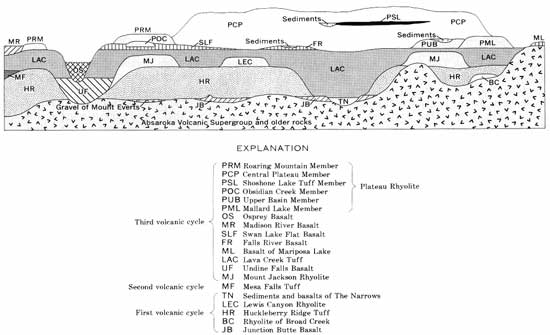
We recognize three cooling units of ash-flow tuff as the major stratigraphic units of the rhyolite plateau and establish them here as the Huckleberry Ridge, Mesa Falls, and Lava Creek Tuffs of the Yellowstone Group. Boyd (1961, p. 393-400) named and described the Yellowstone Tuff, but he did not provide a formal stratigraphic definition of the unit. The two exposures he described in most detail are sections of two of the three ash-flow sheets recognized in this paper. Since these three sheets, as discussed in the following paragraphs, are separated by unconformities representing time spans of 600,000-800,000 years and are associated in their source areas with overlying and underlying lavas, each is designated here as a separate formation. The name Yellowstone Group now replaces the Yellowstone Tuff of the literature (for example, Boyd, 1961; Brown, 1961; Fraser and others, 1969; Witkind, 1969) which clearly has been used to include at least two of our three formations. We define the Yellowstone Group here as the rhyolitic tuffs which constitute the three ash-flow formations designated in this paper. No single exposure shows all three formations in unbroken succession, but the stratigraphic relations are shown by mapping in the Island Park area and in the southern part of the Madison Range, or Henrys Lake Mountains.
The Yellowstone Group lies on rocks as old as Precambrian and as young as early Quaternary. In many areas, particularly in eastern Yellowstone National Park, the group overlies rocks of the Absaroka Volcanic Supergroup of Eocene age (Smedes and Prostka, 1972).
All three formations of the Yellowstone Group consist mainly of welded ash-flow tuff, predominantly devitrified, containing phenocrysts of quartz, sanidine, and sodic plagioclase. Common minor phenocrysts are opaque oxides, clinopyroxene, fayalite, zircon, hornblende, allanite, and chevkinite.
HUCKLEBERRY RIDGE TUFF
We name the Huckleberry Ridge Tuff, the oldest ash-flow sheet of the Yellowstone Group, for the topographic crest east of the Snake River just south of Yellowstone National Park and north of Jackson Lake. The type section (fig. 1) is designated as the cliff exposure at the head of a large landslide 1.8 km N. 10° E. of the Snake River bridge at Flagg Ranch on the highway about 3 km south of the South Entrance of Yellowstone National Park. The Huckleberry Ridge Tuff, locally as thick as 300 m, is exposed widely around the margins of Yellowstone National Park and in surrounding areas south to southern Jackson Hole, north down the valley of the Gallatin River as far as the West Fork, and west into the Island Park region to the edge of the younger lavas of the Snake River Plain. In central Yellowstone Park the formation is largely buried by younger rocks. The Huckleberry Ridge in various areas overlies eroded rocks of virtually every major older unit exposed in the Yellowstone region. West of Yellowstone Park the formation commonly is overlain by the Mesa Falls Tuff, but in most other areas it is most commonly overlain by the Lava Creek Tuff.
The type section of the Huckleberry Ridge is about 170 m thick and consists mainly of welded phenocryst-rich rhyolitic ash-flow tuff forming a single compound cooling unit. The tuff overlies sandstones and shales of Cretaceous age and is eroded at the top, but regional relations indicate that no more than a few meters has been removed along the present topographic surface. The section is divided into three widely mappable informal members on the basis of significant changes in welding and minor variations in phenocryst content. The lowest member, about 45 m thick, consists of a few centimeters of nonwelded to partially welded glassy ash-flow tuff overlain successively by about 1 m of black vitrophyric welded tuff, about 2 m of dark-gray microspherulitic densely welded tuff, and a brown-weathering devitrified zone. The basal part of the member contains abundant (40-50 percent) phenocrysts. About 30 m above the base, phenocrysts become less abundant; from there upward they decrease in size and abundance for about 15 m. This widely mapped zone of relatively sparse phenocrysts contains a thin zone near the top in which the tuff is less densely welded than that below or above, and this zone is used to divide the lower two members. The middle member, about 30 m thick, has a thin basal phenocryst-poor zone; above, it has abundant large phenocrysts, and at the top it contains conspicuous dark-gray to brown crystallized pumice along with light-colored crystallized and collapsed pumice typical of the member as a whole. This two-pumice, large-phenocryst zone is overlain sharply by the third member, about 95 m thick, which is characterized by moderately abundant phenocrysts that are distinctly smaller than those in the underlying units. The upper member shows marked lineation of stretched pumice and alined phenocrysts and minor flowage folding of the compaction foliation.
Basal air-fall tuffs are as much as about 2 m thick north of central Yellowstone Park but are thin or absent to the south. The lower two members of ash-flow tuff of the type section of the Huckleberry Ridge, separated by a relatively phenocryst-poor zone and a partial welding break (a devitrified but less densely welded zone between two devitrified more densely welded zones), have been traced virtually everywhere the formation is found. The commonly lineated, upper member occurs only south of central Yellowstone Park. Although this upper member is demonstrably an ash-flow tuff, in many exposures it superficially resembles a rhyolitic lava flow. This characteristic of the member, which constitutes a large proportion of the highly altered exposures in the Red Mountains in southern Yellowstone National Park, in part led Boyd (1961) to regard the rocks there as mainly rhyolite flows which he designated the Red Mountains Rhyolite. The base of this upper member in many places overlies a thin crystal ash and grades southward from the type section into a separate cooling unit; the Huckleberry Ridge Tuff as a whole, therefore, is a composite sheet.
Potassium-argon dating of sanidine from the Huckleberry Ridge Tuff by J. D. Obradovich (writ ten commun., 1970) indicates an age of 2 m.y.
MESA FALLS TUFF
The Mesa Falls Tuff, the middle ash-flow sheet of the Yellowstone Group, does not crop out within Yellowstone National Park, but we name and briefly describe it in order to provide a complete summary of the Yellowstone Group and to help outline the Quaternary volcanic evolution of the Yellowstone region. The formation is named here for Upper Mesa Falls on the Henrys Fork of the Snake River in the Island Park area of eastern Idaho. The type section (fig. 1) is designated as the roadcut on U.S. Highway 20 about 6.8 km north of Ashton, Idaho. The Mesa Falls Tuff varies greatly in thickness but commonly is more than 100 m thick. It is present mainly in the Island Park area and on the lower slopes of the Centennial Mountains and the southern Madison Range. The Mesa Falls overlies the Huckleberry Ridge Tuff and older units, and in the Island Park area it overlies lavas of the second volcanic cycle that are not discussed in this report. The Mesa Falls most commonly is overlain by the Lava Creek Tuff, but in the Island Park area second-cycle volcanic units also overlie the Mesa Falls.
The type section of the Mesa Falls is shown in a photograph by Hamilton (1965, fig. 3). At that locality a thick basal air-fall pumice and a thin distal ash-flow tuff overlie a buried loess and a deeply weathered outcrop of the lower member of the Huckleberry Ridge Tuff. The basal 5-6 m of the type section of the Mesa Falls Tuff consists of well-sorted and well-bedded air-fall pumice and crystals, commonly several millimeters to a centimeter or more in grain size. This basal air-fall pumice is overlain by phenocryst-rich (about 40 percent) ash-flow tuff about 15 m thick with conspicuously large feldspar phenocrysts (some greater than 1 cm). The ash-flow tuff forms a simple cooling unit, nonwelded and glassy in the basal 1-1/2 m, overlain by a pale-pink vapor-phase zone. The top of the section is eroded, but regional relations show that only the presumed original glassy nonwelded top of the cooling unit, probably never more than a few meters thick, is missing. The Mesa Falls has been traced continuously along the ridges and roadcuts to more densely welded tuff about 5 km north, where the formation is thicker and has a conspicuous pinkish-brown devitrified zone.
|
| FIGURE 3. — Diagrammatic relations between stratigraphic units outlined in table 1. Not all possible stratigraphic relations discussed in text are shown. (click on image for a PDF version) |
The type section is the only easily accessible good exposure of virtually the entire ash-flow sheet. Nevertheless, because the ash-flow tuff there is only a thin distal part of the sheet, the section is not representative in gross lithology of the formation as a whole. For this reason we designate the cliffs along the gorge of the Henrys Fork at Upper Mesa Falls as the principal reference section (fig. 1). Here the characteristic lithology of thicker sections of the formation is seen. A thick pinkish devitrified zone with abundant large phenocrysts forms the wall of the inner gorge of the river at the level of the falls. The base is not exposed but probably is not far beneath the level of exposures. A thickness of about 140 m is exposed. The devitrified zone grades upward into a vapor-phase zone that is poorly exposed on the east side of the upper canyon wall in roadcuts above the falls. Just below the rim of the upper canyon wall near the top of the road to the falls, the Mesa Falls Tuff is overlain by the Lava Creek Tuff, but the contact is not exposed. Basalts cap the section where the road crosses the canyon rim. A section of the Mesa Falls (complete except for the base) is well exposed on the nearly inaccessible west wall of the gorge at Upper Mesa Falls.
Sanidine from the Mesa Falls Tuff has been dated by the K-Ar method by J. D. Obradovich (written commun., 1970) as 1.2 m.y. old.
LAVA CREEK TUFF
The Lava Creek Tuff, the upper ash-flow sheet of the Yellowstone Group, is named here for a stream which enters the Gardner River about 3 km southeast of Mammoth. The formation is divided throughout its extent into two major informal members. They are exposed overlying the Huckleberry Ridge Tuff in a 210-m-thick section in the walls of the upper canyon of Lava Creek and its tributary, Arrow Canyon. This is designated the type area (figs. 1 and 2). Arrow Canyon and nearby parts of Lava Creek canyon are more than 13 km from the nearest roads or trails; there is no readily accessible exposure of the Lava Creek Tuff in which both of its members as well as its base and top are well exposed. We therefore designate a more accessible principal reference section for each of the members.
The Lava Creek Tuff is more than 300 m thick in several areas. The formation occurs widely in Yellowstone National Park and has been traced south to Jackson Lake, westward through much of the Island Park area to the southern foothills of the Centennial Mountains, and southwestward along the margin of the Snake River Plain to the south side of the Snake River about 25 km northeast of Idaho Falls. The Lava Creek in various areas overlies most of the older rock units exposed in the region. Around the margins of the Yellowstone plateau, the Lava Creek commonly overlies the Huckleberry Ridge Tuff. The Lava Creek is overlain by most of the younger units of the third volcanic cycle in and near Yellowstone National Park.
The principal reference section of the lower member is the south-facing cliff of Purple Mountain above an old gravel pit about 1 km east of Madison Junction (fig. 2). The section overlies the Mount Jackson Rhyolite and is overlain a few kilometers northeast by the upper member of the Lava Creek Tuff; a few patches of Madison River Basalt lie on the lower member on benches in the cliff southwest of Purple Mountain. In its basal 300 m the lower member has somewhat fewer and distinctly smaller phenocrysts and is less densely welded than above. Collapsed pumice in this less densely welded basal portion, though not particularly more abundant, is more conspicuous than above; rhyolitic lithic inclusions (including welded tuffs) are especially abundant. Boyd (1961, p. 393) called this basal part the Purple Mountain Pumice Breccia, but we regard it only as a unit of the lower member of the Lava Creek Tuff and do not believe that it warrants a separate formal name. This basal unit is overlain sharply by devitrified densely welded tuff with especially abundant large phenocrysts. This densely welded tuff, about 180 m thick here, is typical of the member in most localities and generally weathers to crumbly dark-brown crudely columnar outcrops or to steep grassy slopes. The lower member of the Lava Creek Tuff is the only part of the Yellowstone Group in which hornblende is more abundant than pyroxene.
Boyd (1961, p. 393) correlated outcrops of partially welded tuff containing abundant lithic inclusions in the Stonetop Mountain area, north of Yellowstone Lake, with the Purple Mountain Pumice Breccia. Our mapping, however, shows that these outcrops are in the upper, not the lower, member of the Lava Creek.
The principal reference section of the upper member is on the east wall of Sheepeater Canyon on the Gardner River 1 km northeast of Osprey Falls (fig. 2). This section was described by Boyd (1961, p. 395) as the only complete section of the Yellowstone Tuff, but it is not a stratigraphically complete section of either the Yellowstone Group or the Lava Creek Tuff. It is a well-exposed section 140 m thick with exposures of both the basal and the upper contacts of the upper member of the Lava Creek. The Lava Creek overlies the Quaternary Undine Falls Basalt, which in turn lies on lower Tertiary intrusive dacite and Cretaceous sedimentary rocks. The member is overlain by the Swan Lake Flat Basalt, which was erupted soon enough after emplacement of the Lava Creek to preserve the unconsolidated ashy and pumiceous top of the member. The basal few meters of air-fall pumice and ash is overlain by about 2 m of phenocryst-rich glassy welded tuff—nonwelded and gray tuff at the base but densely welded black vitrophyre at the top. Above this vitrophyre is about 4-1/2 m of dark-gray microspherulitic densely welded tuff alternating with vitrophyre. Farther above is devitrified generally pinkish brown densely welded tuff with abundant large phenocrysts (a few of them nearly 1 cm) that increase slightly in abundance upward, conspicuous large white collapsed crystallized pumice lenticles, and abundant reddish-brown rhyolitic lithic inclusions. The devitrified zone is almost 90 m thick. It is overlain by an orange-pink vapor-phase zone about 40 m thick. The vapor-phase zone is overlain in turn by 312 m of unconsolidated nearly white glassy ash-flow tuff of the original top of the cooling unit. This is one of the few known exposures of any of the three ash-flow sheets of the Yellowstone Group in which this frothy glassy top, presumed to have been present initially over the entire area of each ash-flow sheet, is preserved. Locally, where the overlying basalt does not have a rubbly basal breccia, the top of the frothy ash and pumice is reddened and even fused to a depth of a few centimeters.
Where the upper member overlies the lithologically very similar lower member, several meters of relatively phenocryst-poor welded tuff occur in the base of the upper member. This phenocryst-poor zone grades downward from densely welded into partially welded at the contact between the two units, and locally a sorted and bedded crystal ash several centimeters thick forms a parting between the two. A section containing this contact is exposed in roadcuts just downstream from Virginia Cascade on the loop road south of the main highway between Norris Junction and Canyon Village, although constant spalling of the cuts generally covers the contact itself.
The Yellowstone caldera formed by collapse of the magma-chamber roof as a result of eruption of the Lava Creek Tuff. The two members were erupted in immediate succession from adjacent but distinct source areas, each of which formed a discrete caldera segment with its own central resurgent dome.
Sanidine from the Lava Creek Tuff has been dated by the K-Ar method by J. D. Obradovich (written commun., 1970) as 600,000 years old. Richmond (1970b, p. 8, 21) noted that ash beds probably derived from the Lava Creek eruptions are slightly younger than deposits of the Cedar Ridge Glaciation (Rocky Mountains) and of the Kansan Glaciation (Great Plains).
| <<< Previous | <<< Contents >>> | Next >>> |
pp/729-B/sec2.htm
Last Updated: 08-Sep-2008