
|
Geological Survey Professional Paper 715—B
Combined Ice and Water Balances of Maclure Glacier, California, South Cascade Glacier, Washington, and Wolverine and Gulkana Glaciers, Alaska, 1967 Hydrologic Year |
SOUTH CASCADE GLACIER
DESCRIPTION
South Cascade Glacier (lat 48°22' N., long 121°03' W., fig. 3) is located in the North Cascades of Washington. This valley glacier occupies roughly one-half of a 6.11-km2 basin. The mean ELA is 1,900 m. Water from the basin flows into the Cascade River then the Skagit River.
|
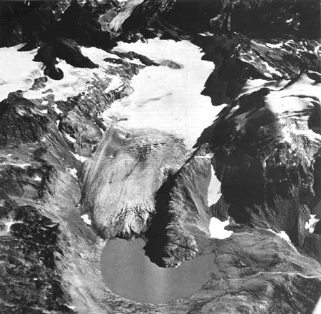
| FIGURE 3.—Oblique aerial photograph of South Cascade Glacier and drainage basin, North Cascade Range, Washington, September 20, 1967. An unusual condition is shown here in that much firn and ice are exposed at higher altitudes around Sentinel Peak (upper left). Yet, at a lower altitude, the glacier still retains a considerable amount of surplus snow. The greater snow accumulation on the lower, more level glacier surface is probably due to a more than normal movement of snow by wind drifting and (or) avalanching from higher altitudes to the glacier. The partial nourishment of glaciers hy this means is an important factor but has received little attention in mass balance studies. It has been calculated that 32 percent of the South Cascade Glacier snow accumulation was by redeposition this year. |
FIELD PROGRAM
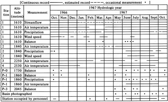
The instrumentation and mass balance measuring program during 1967 was quite similar to that in 1966 (Meier and others, 1971). Most of the recording instruments operated throughout the year except for a short period in the late winter (table 3). Instrument locations together with snowline data during the ablation season are shown on plate 2.
TABLE 3.—Instrumentation at South Cascade Glacier during the 1967 hydrologic year
WEATHER
The weather in the North Cascades during the balance year was characterized by a severe storm in October 1966, heavy midwinter precipitation, a cool, rather dry spring, and an unusually warm and dry summer season. The cloud cover in the North Cascades during the June-September ablation period averaged 15 percent below the long-term mean.
GLACIOLOGIC BALANCES
The measured winter snow balance,  m(s), was
determined by field measurements on May 4-5, 1967. Snow pits and density
cores were used to determine the snow pack water equivalent at index
stations P—1, near the equilibrium line, and P—0, in the
ablation area. More than 100 snow depth soundings were made on the
glacier and in the nonglacierized area of the basin to expand the index
station data to determine values for m(s). The maximum balance, x, occurred on
approximately May 17. The value of x is less than m(s) because it is measured from
the beginning of the hydrologic year, t0. Considerable
storage change, 0, occurred in October 1966 and must be
accounted for when determining x:
m(s), was
determined by field measurements on May 4-5, 1967. Snow pits and density
cores were used to determine the snow pack water equivalent at index
stations P—1, near the equilibrium line, and P—0, in the
ablation area. More than 100 snow depth soundings were made on the
glacier and in the nonglacierized area of the basin to expand the index
station data to determine values for m(s). The maximum balance, x, occurred on
approximately May 17. The value of x is less than m(s) because it is measured from
the beginning of the hydrologic year, t0. Considerable
storage change, 0, occurred in October 1966 and must be
accounted for when determining x:
x = m(s) + 0(i) + δ(s),where δ(s) equals the additional snow accumulation between
May 5 and May 17. The value for δ(s) for the glacier was estimated to be 0.05 m and
0.03 for the basin on the basis of precipitation and temperature records
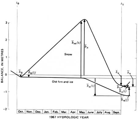
(pl. 2, table 4, fig. 4).
TABLE 4.—Ice and water balances, South Cascade Glacier basin, 1967 hydrologic and balance years
[Values and errors in metres water equivalent expressed as averages over the glacier and basin except where indicated. Date: Hydrologic year, Oct. 1, 1966 (t0) through Sept. 30, 1967 (t1)]
| Glacier |
Basin |
Date | Term | Explanation | |||
| Value | Error | Value | Error | ||||
Yearly mass balances | |||||||
Yearly mass balances | |||||||
| a |
-0.58 | 0.15 | -0.27 | 0.08 | Hydrologic year | Annual balance | Total change in snow, firn, and ice storage during the 1967 hydrologic year, from t0 to t1; approximately equal to difference between precipitation as snow and melt-water runoff for the hydrologic year. |
| n |
-.63 | .15 | -.31 | .08 | Oct. 17, 1966 to Oct. 14, 1967 | Total mass net balance | Change in storage from the minimum balance in 1966 autumn (t0') to the minimum in the 1967 autumn (t1'). |
| a(fi) |
-.58 | .15 | -.27 | .08 | Hydrologic year | Annual firn and ice balance | Change in firn and ice storage during 1967 hydrologic year; excludes late summer snow on the basin. |
Accumulation and ablation | |||||||
| m(s) |
3.28 | 0.12 | 2.22 | 0.23 | May 4-5, 1967 | Measured winter snow balance | Snowpack on the 1966 summer melt surface (ss0); measured in late winter or spring in pits and by probing. |
| x |
3.18 | .15 | 2.18 | .25 | May 17, 1967 | Maximum balance | Storage change from the beginning of the hydrologic year
(t0) to the maximum in the spring. Winter balance (bw)
equals maximum balance (x) plus the absolute
value of the initial balance increment (0). |
| a(f) |
.50 | .10 | .23 | .05 | Hydrologic year | Annual firnification | The increment of new firn in the accumulation area at t1, measured after melting from this residual snowpack (firn) ceases in the autumn.. |
| a(i) |
-1.08 | .10 | -.50 | .05 | do | Annual ice balance | Ice and old firn melt in the ablation area during the hydrologic year. |
 a a |
3.40 | .20 | 2.27 | .25 | do | Annual accumulation | Total accumulation of snow between t0 and t1. |
 a a |
3.98 | .20 | 2.54 | .20 | do | Annual ablation | Total ablation of snow, ice, and old firn between t0 and t1. |
Values relating annual and net ice balances | |||||||
| 0 |
-0.10 | 0.05 | -0.05 | 0.05 | Oct. 117, 1966 | Initial balance increment | Storage change between time of minimum in 1966 autumn (t0') and beginning of hydrologic year (t0). |
| 0(s) |
0 | 0 | 0 | 0 | Initial snow balance | Snow accumulated on the 1966 summer surface (ss0) at beginning of hydrologic year (t0); measured in pits and by probing. | |
| i |
-.15 | .02 | -.07 | .02 | Oct. 1 to Nov. 5, 1966 | Initial ice balance | Initial ice balance Ice and old firn melt after t0 and before the winter snowpack covers the glacier; measured by ablation stakes. |
| 1 |
-.05 | .02 | -.02 | .01 | Oct. 1-14, 1967 | Final balance increment | Storage change between time of minimum in 1967 autumn and the end of the hydrologic year. |
| 1(ls) |
0 | 0 | 0 | 0 | Final late snow balance | Snow accumulated on the 1967 summer surface (ss1) at t1. | |
| 1i |
-.10 | .05 | -.04 | .02 | do | Final ice balance | Ice and old firn melt after t1 and before the next year's snowpack covers the glacier. |
Glacier and basin dimensions | |||||||
| S(fi) | 12.80 | 0.04 | 3.15 | 0.05 | Sept. 30, 1967 | Glacierized area | Glacier value includes firn and ice areas which normally are attached to the main trunk glacier. Basin value is the main glacier plus all other small glaciers and perennial snowfields in the drainage basin. Ice-cored moraine and other permafrost areas are not included as glacierized areas. |
| S | 12.80 | .04 | 6.11 | .02 | do | Total area | Glacier and water drainage basin above the stream gaging station. |
| AAR | 2.58 | .05 | .29 | .09 | do | Accumulation area ratio | Area of new firn, accumulation area, divided by the total area. An index of annual balance. |
| ELA | 1,870 | 20 | do | Equilibrium line altitude | Average altitude where snow ablation equals snow accumulation. An index of annual balance. | ||
| δL | -17 | 3 | Hydrologic year | Advance or retreat | Average horizontal distance change of terminus of the glacier in direction of flow. | ||
Precipitation and runoff | |||||||
| pa | 2.17 | 0.30 | Hydrologic year | Gaged annual precipitation | Total snow and rain caught during the hydrologic year by a shielded gage at 1,610-m altitude. | ||
| pa(r) | .42 | .08 | do | Gaged annual precipitation as rain | Precipitation occurring as rain caught during the hydrologic year by the same gage at 1,610-m altitude. | ||
 a a |
4.00 | 0.35 | 2.87 | .20 | do | Annual basin precipitation | Area averaged snow and rainfall measured during the hydrologic year by precipitation gages and snow balance measurements. |
| a(r) |
.60 | .05 | .60 | .05 | do | Annual basin precipitation as rain | Area averaged rainfall measured by gages during the hydrologic year. Rain distinguished by air temperature records, visual observations, and photographic record. |
| pa* | 3.56 | .16 | do | Calculated annual precipitation | Area average annual snow and rain precipitation; the sum
of annual stream runoff and annual storage change
(a). | ||
 a a |
3.83 | .15 | do | Annual runoff | Stream discharge for the year divided by glacier or basin area, expressed as average depth of water over the area; measured by stream stage recorder and stream discharge measurements. | ||
1Square kilometres. 2Dimensionless. | |||||||
|
| FIGURE 4.—The balance of South Cascade Glacier, 1967 hydrologic year. (Refer to table 4 for additional values.) |
During the early ablation season, over 30 ablation
stakes were installed on the glacier and other areas of snow in the
basin. These stakes were periodically measured and serviced. The last
readings of the season were made in late October by probing through 1-2
m of snow to the firn or ice for the minimum 1967 balance. The ablation
stake data, periodic density cores and pits at index stations, and fall
photography resulted in a map of net balance, n. Because the station was not
occupied October 1, 1967, estimates for values of i, i(ls), and i(i) were made
based on precipitation and temperature records.
Ablation during the summer was intense and resulted
in a proportionally greater amount of mass loss from the higher levels
of the glacier than in previous year. As a result, the equilibrium line
altitude for 1967 was 1,870 m, slightly below the average equilibrium
line altitude of 1,900 m. Despite the large spring snowpack the annual
balance on September 30, 1966, was -0.58 m. The values for glacier
accumulation and ablation (ca and a) are somewhat
higher than x-a as they account for snow that fell and
melted before May 17 and snow that fell and melted after May 17.
HYDROLOGIC BALANCE
The hydrologic balance throughout the year for the
basin is shown on plate 2D. The hydrologic balance is the
difference between precipitation and runoff. This may appear to be a
simple calculation; however, there are several complications.
Precipitation is difficult to measure directly and accurately. The
recording gage catch of 2.17 m, Pa, is probably much
below the actual precipitation. This is because most of the
precipitation occurs as wind-driven snow, which the gage catches
inefficiently, and because the gage is located at a nonrepresentative
place in the basin—the lowest area. A better measurement is to
determine a value for basin rainfall, by use of several simple gages
scattered over the basin in the summer, and a value for basin snowfall,
by determining the water equivalent of the maximum snow accumulation at
many points in the basin. The sum of the two values for 1967 was 2.87 m,
designated a. This method does not account for snow
that fell and ablated before the maximum snowpack was measured.
The second method, a*, is the sum of the annual
runoff and the measured storage change or basin balance. The main
problem with this method is that liquid storage within the glacier is
unaccounted for so that runoff does not equal input. The difference
between a
and a* (0.69 m) can be due to either
or both errors in measurements and (or) delayed runoff. In the
cumulative precipitation curve (pl. 2D), a* was used as basin
precipitation and distributed according to the gage precipitation at
site 1. Neither method accounts for evaporation, condensation or
sublimation.
Total runoff for the year was 3.83 m—15 percent derived from glacier ice melt, 49 percent from glacier snow melt, 20 percent from nonglacier snow melt, and 16 percent precipitation as rain.
| <<< Previous | <<< Contents >>> | Next >>> |
pp/715-B/sec3.htm
Last Updated: 28-Mar-2006