
|
Geological Survey Bulletin 587
Geology of the Great Smoky Mountains National Park, Tennessee and North Carolina |
NOTEWORTHY EXPOSURES IN THE AREA
Several roadside parking areas in and near Great Smoky Mountains National Park afford excellent opportunities to examine geologic features described in the foregoing pages. The best of these are described in the following notes. With the geologic map, the visitor will be able to identify the formations and structures exposed elsewhere.
The exposures described here are along the more heavily traveled highways: Tennessee Highway 73 from the Townsend entrance to the park at the southeastern edge of the Tuckaleechee Cove window to the junction with U.S. Highway 441 at park headquarters; U.S. Highway 441 southward to the crest of the mountains at Newfound Gap; and the nearby Forney Ridge parking area at the end of the spur road to Clingmans Dome. Most of these descriptive notes and the accompanying sketches are taken from a guidebook to the geology of the park area (Hadley and others, 1955).
Townsend entrance to Great Smoky Mountains National Park
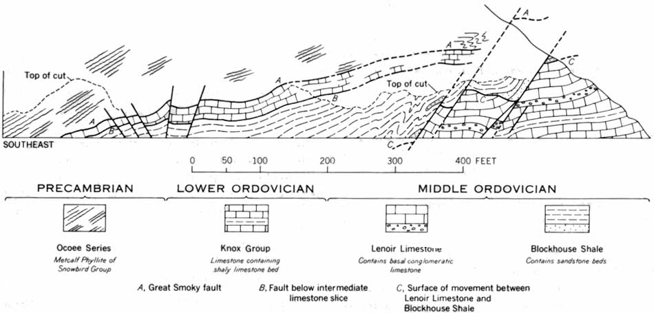
Just northwest of the entrance to the park on Tennessee Highway 73, a cut 900 feet long exposes rocks of the Ocoee Series (Metcalf Phyllite of the Snowbird Group) and the Ordovician System in contact along the Great Smoky fault (fig. 4). The main fault (A of fig. 4) is obscurely exposed at the southeast end of the cut and rises at a low angle into the slope above. The following features deserve notice:
1. The Metcalf Phyllite above the Great Smoky fault consists of chloritic and sericitic sandy phyllite, whereas the shale beneath, of Middle Ordovician age, has been slickensided and crumpled but contains no metamorphic minerals. The fault thus marks a metamorphic discontinuity, which indicates that the metamorphism of the Metclalf took place before it was thrust over the Ordovician rocks.
2. Between the overriding phyllite and the shale, intensely fractured and crushed blue-gray limestone, 5-25 feet thick, forms one of the several higher slices of the Lower Ordovician part of the Knox Group that were dragged along the sole of the fault. The Knox Group also occurs in normal stratigraphic order beneath shale, sandstone, and limestone at the northwest end of the cut.
3 Exposures high at the northwest end of the cut indicate that bedding in the Middle Ordovician shale and sandstone is disharmonious with that of the limestone below, although the one lies in normal stratigraphic order on the other. This indicates that these rocks are separated by a zone of movement (line C, fig. 4) which developed during emplacement of the main thrust above.
4. The overridden Ordovician rocks are cut by a series of normal faults which dip steeply southeast; whether these faults also break the Great Smoky fault above cannot be determined. One of them, which drops shale against limestone, is well displayed near the middle of the cut.
|
| FIGURE 4.—The Great Smoky fault and related structures in cuts on Tennessee Highway 73 at Townsend entrance to the Great Smoky Mountains National Park. (click on image for an enlargement in a new window) |
The Sinks
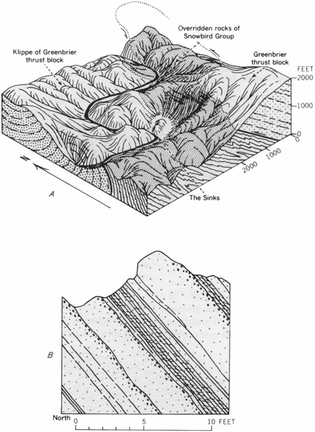
At The Sinks there is a bridge over the Little River where it drops abruptly through a series of cascades and whirlpools cut in a rock gorge. The Sinks are not a feature of limestone solution as the name might suggest. The abrupt increase in the gradient of the river results from its cutting through an old meander neck; a former course of the river may be traced around the rock knob just southeast of the bridge (fig. 5A).
The rock at The Sinks is thick-bedded sandstone of the Thunderhead Sandstone. Beds dip southeast but are overturned, as indicated by inverted graded bedding in the sandstone and by the weak cleavage in the slate interbeds, which dips at a lower angle than the bedding (fig 5B).
Structurally, these rocks are part of a klippe—a detached downfaulted and folded segment of the Greenbrier thrust sheet.
|
| FIGURE 5.—Geologic features at The Sinks on Tennessee Highway 73 at Blount-Sevier County line. A, Block diagram showing cutoff meander neck of Little River, and interpretation of Thunderhead Sandstone as an infolded detached part (klippe) of the Greenbrier thrust block. Drawing by Philip B. King. B, Sketch of outcrops at bridge, showing overturned beds as indicated by graded bedding and the low dip of cleavage in slate beds compared with steep dip of beds. Drawing by H. W. Ferguson and Philip B. King. (click on image for an enlargement in a new window) |
Maloney Point
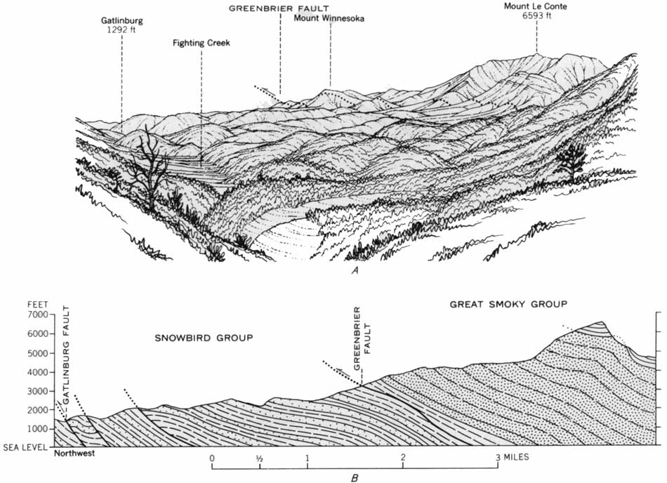
This locality affords one of the finest panoramas in the Great Smoky Mountains. Mount Le Conte, which towers to the east above the observer, has an altitude of 6,593 feet, 1 mile higher than the town of Gatlinburg, which is hidden in the hills to the north (fig. 6).
The topography in this view reflects the bedrock structure. The steep face of Mount Le Conte is formed of rocks of the Great Smoky Group, and the trace of the Greenbrier fault on which they lie is near the base of the slope (fig. 6). The lower ridges to the north are carved from the less massive rocks of the Snowbird Group.
The trace of the Greenbrier fault extends toward Fighting Creek Gap, but it is cut off below the overlook by the Gatlinburg fault. Erosion of crushed and fractured rocks along the trace of the latter has produced Fighting Creek Gap and the straight trenchlike course of Fighting Creek to the east. Cove Mountain, north of Fighting Creek, is formed of rocks of the Great Smoky Group in a part of the Greenbrier thrust sheet that lies on the downthrown side of the Gatlinburg fault.
|
| FIGURE 6.—Geologic features visible from Maloney Point on Tennessee Highway 73 a little east of Fighting Creek Gap. A, All the rocks encompassed in this view belong to the Ocoee Series: Mount Winnesoka is supported by the Elkmont Sandstone of the Great Smoky Group, and the other high mountains to the right (south) are supported by the overlying Thunderhead Sandstone and Anakeesta Formation. The trace of the Greenbrier fault lies at the base of the steep slopes from Mount Winnesoka to the foreground, and the Roaring Fork Sandstone of the Snowbird Group crops out on the foreground ridges. The Gatlinburg fault follows the valley of Fighting Creek on the left. Drawing by Philip B. King. B, Geologic section approximately along skyline of panorama. (click on image for an enlargement in a new window) |
Chimneys Overlook
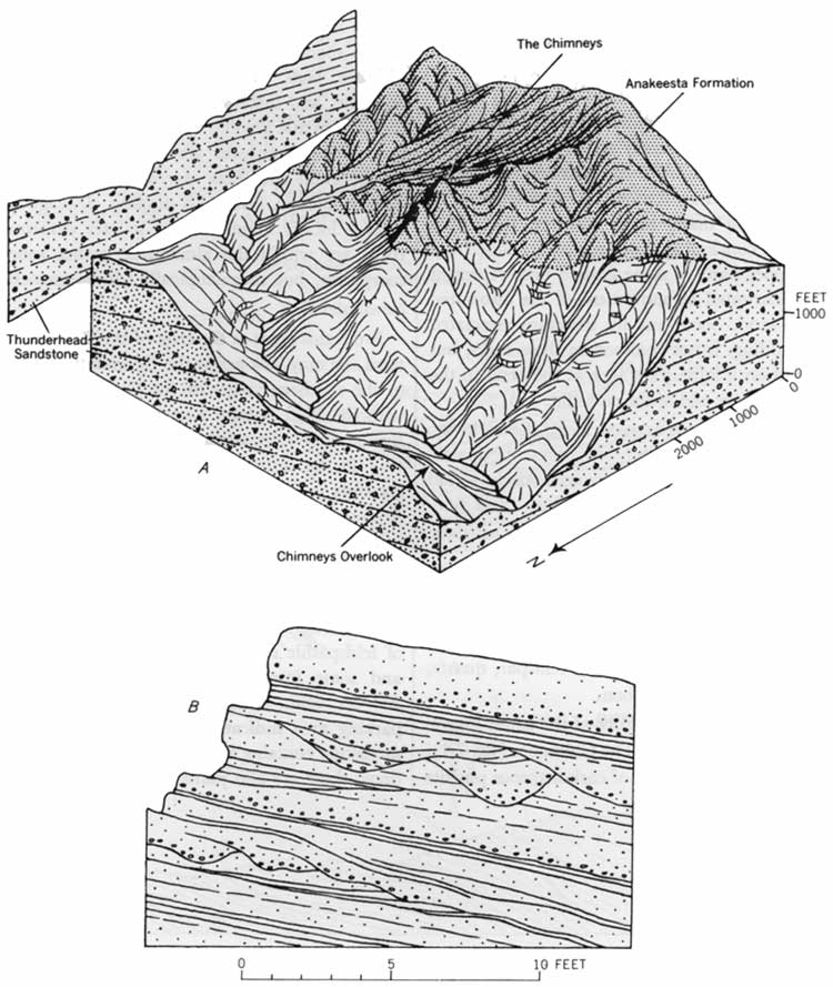
Outcrops of sandstone and interbedded slate in the long series of roadcuts across the highway from the lookout are typical of the Thunderhead Sandstone of the Great Smoky Group. Graded bedding is the dominant structure, although crossbedding can be seen at a few places. At the base of some beds are indications of erosion of the underlying bed. A few beds show complete gradation, beginning at the base with poorly sorted quartz-feldspar conglomerate, passing upward through coarse sandstone, medium- to fine-grained sandstone, and slaty siltstone to fine-grained slate. In many beds, however, the initial conglomerate and concluding slate are absent. Slate fragments in the upper parts of some graded beds represent layers of mud disrupted by movement of the associated unconsolidated sand. Scour-and-fill structure associated with graded bedding, is not common in these rocks, but is well displayed on a large joint face at the bend in the highway near the lower end of the cuts (fig. 7B).
In about 800 feet of beds exposed along the highway, the following proportion of rock types is present: quartz-feldspar conglomerate, 6 percent; coarse poorly sorted feldspathic sandstone, 24 percent; medium- and fine-grained feldspathic sandstone, 60 percent; slaty siltstone, 9 percent; and slate, 1 percent.
The coarser grained rocks are composed largely of quartz and microcline, with minor amounts of sodic plagioclase, muscovite, biotite, iron ores, and carbonate. The slate consists of muscovite, potash feldspar, quartz, some iron oxides, and a little carbon.
Across the valley of the West Fork of the Little Pigeon River are the two sharp peaks of The Chimneys (fig. 7A), whose upper parts are composed of carbonaceous phyllite of the Anakeesta Formation lying conformably on the Thunderhead Sandstone.
|
| FIGURE 7.—Geologic features at Chimneys Overlook, on U.S. Highway 441, 7 miles south of Gatlinburg, Tenn. A, Block diagram of The Chimneys showing Thunderhead Sandstone overlain by the Anakeesta Formation. B, Sketch of part of roadcut showing graded bedding and channeling in feldspathic sandstone of the Thunderhead Sandstone. Drawings by Philip B. King. (click on image for an enlargement in a new window) |
Walker Camp Prong
The Anakeesta Formation is exposed in the streambed and in roadcuts along the highway. The formation here includes beds of coarse-grained sandstone, siliceous dolomite, and intraformational conglomerate, as well as the dark pyritic phyllite that is characteristic of the formation. These exposures are near the trough of a large synclinorium and show several minor folds with a steep easterly plunge. Southeast-dipping cleavage in the slaty beds is locally crenulated by a later deformation. The rocks are within the almandine garnet zone of metamorphism, but megascopically visible garnets are rare.
Newfound Gap
From this point at the crest of the Great Smoky Mountains one may look across the Oconaluftee fault-line valley to the southern ridges of the Great Smoky Mountains, with the Plott Balsam Range (S. 40° E. to S. 65° E.), Bryson City (due south), and Clingmans Dome (S. 52° W.) in the distance. The rocks exposed in the nearby roadcuts are interbedded sandstone and phyllite of the Anakeesta Formation of the Great Smoky Group; the beds are overturned toward the northwest on the southeast limb of the Alum Cave syncline.
Forney Ridge
The rocks exposed at the parking area are thick beds of feldspathic sandstone of the Thunderhead Sandstone and some interbedded finer grained rocks. Beds dip 25°-35° SSE., and graded bedding at the east end of the parking area indicates that they are right-side up. The sandstone contains many subspherical calcareous concretions; there are also joints filled with quartz and siderite.
| <<< Previous | <<< Contents >>> | Next >>> |
/sec3.htm
Last Updated: 20-Nov-2006