
|
Geological Survey Professional Paper 554—D
Cenozoic Volcanic Rocks of the Devils Postpile Quadrangle, Eastern Sierra Nevada California |
BASALT OF THE RED CONES
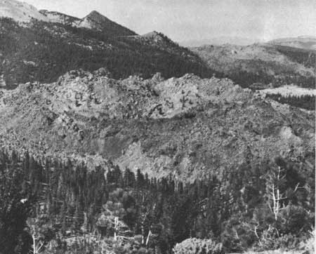
At the point where Crater Creek tumbles from a bench above the Middle Fork of the San Joaquin River—a bench which Matthes (1960, p. 43) considered part of the Broad Valley Surface—two basalt cinder cones lie on either side of the creek, and associated basalt flows cascade down the slope into the Middle Fork valley. The Red Cones were previously considered contemporaneous with, and a source of, part of the andesite of the Devils Postpile in the Middle Fork valley. Unlike the andesite of the Devils Postpile, however, the basalt of the Red Cones is typically vesicular with prominent phenocrysts of plagioclase and olivine. Moreover, the Red Cones have obviously not been glaciated, as has the andesite of the Devils Postpile; Matthes (1960, pl. 1) and Erwin (1934, p. 49) attributed this to the elevation of the cones above the Wisconsin glaciers in the Middle Fork valley. However, the associated flows extending into the Middle Fork valley also escaped glaciation—not only is there a complete absence of glacial erratics, striations, or polish, but the flows also exhibit scoriaceous and rubbly surfaces of a type nowhere present on the glaciated andesite of the Devils Postpile. The basalt of the Red Cones is therefore considered to be of post glacial, or Recent, age. The Red Cones still exhibit summit craters (fig. 11), and a detailed examination of aerial photographs suggests that most of the flow material was erupted from the western base of the southern most of the two craters. The flow has been only slightly modified by subsequent erosion.

|
| FIGURE 11.—The northernmost of the two Red Cones as viewed from the southern cone. Note breached summit crater. |
RHYOLITE
In the northeast corner of the quadrangle is a series of rhyolite domes that have been considered to be a southern extension of the Mono Craters and have been described in some detail by Mayo, Conant, and Chelikowsky (1936). This series consists of six rhyolite domes, alined in a north-south direction over a distance of 6 miles, beginning about 2 miles south of the main mass of the Mono Craters. They tend to be nearly equidimensional and range in size from less than half a mile to nearly a mile in diameter. The four southern most domes are in the Devils Postpile quadrangle.
There is little doubt that these domes are of very recent origin; for erosional modification of their forms is negligible and several of them support no vegetation. Each has a multiphase origin, which is best understood by comparison with Panum Crater at the northern end of the Mono Craters, where evidence of the evolution of a dome has been excellently preserved (Williams, 1932; Putnam, 1938). At Panum Crater the initial phase involved the excavation of an explosion pit with the expulsion of vast quantities of pumice and the construction of a pumice-lapilli rim around the perimeter of the pit. This explosive phase was succeeded by the protrusion of a nearly solid column of pumiceous obsidian and partly crystalline material in the form of a dome on the floor of the explosion pit. As the dome rose, it tended to fracture and spread laterally, with blocks of pumiceous obsidian spalling off and accumulating in steep talus slopes at its margins.
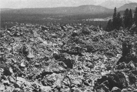
The two larger domes in the Devils Postpile quadrangle—the one just south of Deadman Creek and the other just south of Dry Creek—had a similar mode of origin. However, these two domes spread laterally during their protrusion so that they almost completely overwhelmed their original lapilli cones and thus nearly erased all evidence of the earlier explosive phase of their eruption. The dome just south of Deadman Creek (fig. 12) has only a small remnant of its lapilli rim on its southwest side, and the dome south of Glass Creek has none. The top surfaces of each of these domes are very irregular with numerous spires and loosely piled, angular blocks of pumiceous obsidian (fig. 13). They have a generally concentric structure which is obscure on the surface but readily apparent on aerial photographs (fig. 14). The small tree-covered dome north of Deadman Creek is probably of the same origin, having similar spires and an irregular blocky surface. This dome, however, is slightly older than the two larger domes, for it is mantled with debris from later explosions and its surface structure consequently obscured.
|
| FIGURE 12.—Rhyolite dome south of Deadman Creek as seen from Deer Mountain. Dome is about three-quarters of a mile in diameter. A second rhyolite dome, just south of Glass Creek, can be seen in the right middle distance, Photograph by Gerhard Schumacher. |
|
| FIGURE 13.—Upper surface of rhyolite dome south of Glass Creek showing typical irregular blocky surface. Taken from top of dome in right middle distance of figure 12. |
|
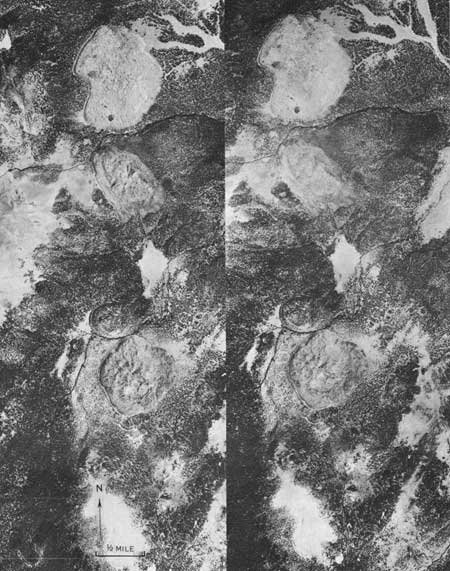
| FIGURE 14.—Vertical aerial photographs of Deer Mountain area, mounted as a stereopair. Main features from south to north are the Inyo Craters, Deer Mountain, and several rhyolite domes. Note remnant of lapilli rim on southern side of rhyolite dome south of Deadman Creek. |
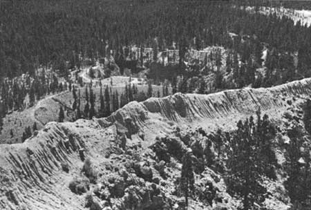
Deer Mountain, the southernmost of the rhyolite domes, has a somewhat more complex history. It may have had an initial origin similar to that of the other domes, but this has been obscured by a late explosive phase, which blasted a summit crater and expelled large quantities of material, including the fine ash that mantles the mountain and gives it the appearance of a volcanic cone and not a dome. Several explosion pits near the base of the mountain, the largest two of which are known as the Inyo Craters (fig. 15), further attest to the late explosive phase.
|
| FIGURE 15.—View of Inyo Craters from Deer Mountain. Ash covered rim of summit crater on Deer Mountain can be seen in foreground. |
A radiocarbon age determination on a log buried within the ejecta that form the parapet of the southern most of the Inyo Craters yielded an age of 650±200 years (lab. No. W—1431). However, a minimum age of 500 years for the craters, slightly older than the minimum radiocarbon age, is required by the fact that 400-year-old pines and firs, whose age is based on ring counts of recently cut specimens, are growing within the craters (fig. 15). Allowing 100 years for trees to become established after eruption fixes the minimum age of the craters at 500 years. The craters, therefore, must have formed between 500 and 850 years ago (Rinehart and Huber, 1965).
PUMICE
Pumice of varying thickness is ubiquitous in most of the Devils Postpile quadrangle east of the Ritter Range, and has obscured many stratigraphic relations between the various Cenozoic units.
The pumice cover is most extensive on the east flank of the San Joaquin Mountain ridge and in the lowlands to the east. Much of this pumice was undoubtedly derived from explosive eruptions associated with the rhyolite domes just described and the Mono Craters farther to the north. It is also probable, however, that large quantities of pumice were ejected during one or more phases in the formation of Mammoth Mountain; much of the pumice in the valley of the Middle Fork of the San Joaquin River and in the vicinity of Pumice Butte, southwest of Mammoth Crest, may have come from this source. Despite its name, Pumice Butte, as has been noted, is an andesitic cinder cone and therefore an unlikely source of pumice in that area, although Birman (1964, p. 7) suggested this possibility. No other likely source of pumice within the San Joaquin drainage basin was noted.
A study of the surficial pumice in and around the Mammoth Embayment and Mono Basin should contribute much to the understanding of volcanism in this region over the past few million years, particularly in the light of the recent success of similar studies (Powers and Wilcox, 1964; Czamanske and Porter, 1965). Our knowledge of the volcanic history of the region will not be complete until such a study has been made.
THERMAL ACTIVITY
Extensive thermal activity in the general Mammoth Lakes area also attests to the recency of volcanic activity. Although hot springs and areas of thermal alteration are more numerous in the Mount Morrison quadrangle to the east (Rinehart and Ross, 1964; McNitt, 1963), Mammoth Mountain itself is a thermal area, and hot springs exist at two other localities in the Devils Postpile quadrangle.
Until at least the late 1950's, there were a number of active fumaroles near the summit of Mammoth Mountain, and indications of thermal alteration are visible over an extensive area. On the south flank of Mammoth Mountain, within a less extensive area of thermal alteration, just north of Mammoth Pass, a few small steam vents are still active.
The hot spring at Reds Meadow emerges from a grassy slope underlain by the tuff of Reds Meadow. It appears to issue from near the base of the lower zone of intensely welded tuff, which exhibits conspicuous jointing in nearby outcrops. As the tuff is an ash flow whose source we believe to be outside of the Reds Meadow area, it is unlikely that the hot spring is genetically related to the tuff. In fact, it cannot be related to any episode of local volcanic eruptive activity. Nor can Fish Creek Hot Springs be related to known volcanism; for they issue from a grassy slope underlain by granitic rocks, 3 miles from the nearest exposure of Cenozoic volcanic rocks. In addition, several cold springs rich in carbon dioxide are in the quadrangle, but their relation to volcanism, if any, is unknown.
SUMMARY
By late Pliocene time, the rolling upland surface of Matthes' Broad Valley erosion stage had been considerably incised during the Mountain Valley and possibly the Canyon erosion stages. The Middle Fork of the San Joaquin River appears to have had a principal tributary whose source was east of the present Sierran divide; the ancestral channel crossed what is now the drainage divide, probably in the area between Deadman Pass and Two Teats. Upon this surface, somewhat less than 4 million years ago, large quantities of andesite and basalt were erupted from scattered vents to cover an extensive part of the quadrangle. Shortly thereafter, the quartz latite of Two Teats buried a large area in the northeastern part of the quadrangle.
It is possible that some of this volcanic activity was related to an early stage in the formation of the Long Valley volcano-tectonic depression, although at least some of the movement along the western perimeter fault occurred later. If the relationships are analogous to those at the Valles Caldera, N. Mex., this faulting probably was associated with the eruption of the Bishop and Reds Meadow ash-flow tuffs, the next major volcanic episode.
About 0.7 million years ago the tuff of Reds Meadow was erupted into the valley of the Middle Fork of the Sail Joaquin River, which probably had been previously glaciated. In a relatively brief period of time, several cubic miles of the tuff was almost completely removed from the valley, possibly during a glacial advance, and subsequent eruption of the andesite of the Devils Postpile followed about half a million years ago.
By this time it is probable that the Long Valley volcano-tectonic depression had formed, and quartz latite was erupted to form Mammoth Mountain on the periphery of the depression. Subsequently, other minor andesites and quartz latites were erupted and were overridden by glaciers.
Two Recent, or postglacial, events were the eruption of the basalt of the Red Cones in the Middle Fork valley and the extrusion of the rhyolite domes in the northeast corner of the quadrangle. Minor phreatic explosions in and near the domes, resulting in craters up to 600 feet in diameter, occurred as recently as 500 to 850 years ago, and thermal activity continues to the present.
| <<< Previous | <<< Contents >>> | Next >>> |
pp/554-D/sec5.htm
Last Updated: 18-Jan-2007