
|
Geological Survey Professional Paper 504—A
Glacial Reconnaissance of Sequoia National Park California |
FOREWORD
In 1905, the U.S. Geological Survey assigned François E. Matthes to make a large-scale (1:24,000) map of Yosemite Valley. The classic Yosemite Special map which resulted enhanced Matthes' well-established reputation as a master topographer, but paradoxically it contributed to his decision to discontinue topographic surveying. His sojourn among the sublime but imperfectly understood features of the "Incomparable Valley" had confirmed a conviction that his deepest interest lay in studying the genesis of landforms rather than in depicting them on topographic maps. Matthes' decision in favor of geology was not the result of any sudden impulse. He had long been a serious student of glacial geomorphology and geology, he had published papers in these fields, and he had spent a year at Harvard University taking advanced courses under William Morris Davis, the "father of geomorphology." The opportunity to engage in geologic work on a full-time basis came in 1913, in which year Matthes was officially transferred from the Topographic Branch of the Survey to the Geologic Branch.
The Yosemite mapping project had other far-reaching consequences. Quite logically, the first geologic assignment given Matthes was to return to Yosemite to investigate the origin of this celebrated valley, a subject which had been a matter of controversy ever since the Whitney surveys in the 1860's. Matthes' painstaking research eventually produced USGS Professional Paper 160, "The Geologic History of Yosemite Valley," a monograph of great and enduring significance.
As his Yosemite investigations progressed, Matthes felt the need for testing his tentative conclusions by comparative study of other valleys in the Sierra Nevada that, presumably, had had much the same history. Therefore he extended his field studies into several major drainage basins of the west slope. These studies, besides serving their immediate purpose, opened up many new geological vistas, some of which involved fundamental questions pertaining to the Sierra Nevada as a whole.
After the Yosemite report was published, Matthes gave renewed attention to these broader problems and during the 1930's he made a succession of geological reconnaissances, particularly in the central and southern Sierra Nevada. On these explorations he employed whatever means were practicable. For the most part, he depended on pack trips, a mode of transportation at which he had become expert from many years of topographic surveying. "Packing in" enabled him to establish camps in remote regions otherwise inaccessible because they were far from railroads, roads, and even trails. Areas surrounding his base camps were explored on horseback or on foot. In the later years, when better roads were available, he got about also by car. On one occasion, in 1936, he employed a chartered plane to make an aerial survey of the High Sierra in the Mount Whitney region. (His companion on this trip was Conrad Wirth, later Director of the National Park Service.)
The difficulties of the Sierra terrain make Matthes' accomplishments in covering the territory all the more impressive. There were few parts of the Sierra Nevada, especially throughout the middle and upper reaches of the broad west slope, which he did not come to know firsthand. The times demanded much such reconnaissance work, and a number of geologists became highly proficient at it. Matthes was outstandingly successful in making geological surveys in mountainous regions.
The results of Matthes' Sierra studies were summarized in several general papers. However, he earnestly desired to report more fully on certain specific areas. This hope was never realized. Though he worked on several longer papers whenever he could do so, the opportunities were infrequent, for other assignments of more immediate urgency if not greater importance generally took precedence. Thus he came to regard the completion of these reports as something that would have to wait until after his retirement. On June 30, 1947, he did retire, and he moved to California; but the following year, before he was fairly started with his writing, he suffered a brief and fatal illness.
Matthes had entered into negotiations with the University of California Press for the writing of two books intended for the general public. In 1949, at the request of the publisher and Mrs. Matthes, I endeavored to carry out these plans; and consequently, in 1950, two works were published (Matthes, 1950a, b) in connection with observance of the Centennial Year of California. In the Geological Survey and in the Sierra Club, interest was also manifested in posthumous works which might embody the substance of Matthes' studies, even though they could not attain the exact form or completeness that he would have given them. The Geological Survey assigned me to look into these possibilities. Review of the Matthes' papers indicated that some of the materials left by Matthes might best serve for reference use, in connection with future glacial and geomorphological studies, but that two significant reports might be prepared for publication.
There resulted, as a first product of this undertaking, USGS Professional Paper 329, "Reconnaissance of the Geomorphology and Glacial Geology of the San Joaquin Basin, Sierra Nevada, California," published in 1960. The paper herewith published is the second of the two reports planned. In a sense these are companion works. However, since Matthes' geomorphological studies in Sequoia National Park have previously been published (Matthes, 1937, 1938, 1950a) and little new information could be added the emphasis in this paper is on glacial geology, and only brief incidental attention is given to such subjects as erosional history, exfoliation, and avalanche sculpture.
The glacial terminology that Matthes used is retained in this report, although it departs from the current Geological Survey usage as outlined in the Code of Stratigraphic Nomenclature prepared by the American Commission on Stratigraphic Nomenclature (1961). For example, Matthes used the term "stage" for glacial episodes such as El Portal, Glacier Point, and Tahoe, whereas the code (p. 660, art. 40) specifies the term "glaciation" for these episodes. Similarly, Matthes used the term "substage" for subdivisions of a glaciation, whereas current usage employs the term "stade."
A rather detailed description of the topography of Sequoia National Park ("Geographic Sketch"), which Matthes had almost completed, is included in full because of the valuable picture it gives of the park area.
As a preliminary to the preparation of this report, I spent the period from July 22 to August 27, 1952, in Sequoia National Park working from camps in Giant Forest, Bearpaw Meadow, Mineral King, and the Kern Canyon. This fieldwork refreshed my memory of features already familiar and acquainted me with others not previously seen. Subsequently, a procedure was followed that was, in the main, similar to that adopted for preparation of Professional Paper 329. The attempt was made to prepare a unified account that would be as complete as possible from the materials at hand, and that would set forth Matthes' observations and conclusions, and retain, wherever feasible, his own words. This procedure involved the synthesis of information from many different sources, particularly field notes and maps, sections of text written in longhand with various degrees of finish, annotated photographs, and published papers. The project further necessitated both the transfer of information from field maps to an unfinished office map and the completion of three topographic profiles. No outline for a report was found, but the source materials at hand, as well as those used for the San Joaquin report, provided working guides for the organization of material and filling in of gaps in the report. The photographs proved particularly useful. In taking these, Matthes had kept in mind the needs of the interpretative program of Sequoia National Park and had made a special effort to secure a comprehensive, illustrative series. Many of these he had annotated fully for use in his so-called "Sequoia Albums" (Matthes, 1950a).
It is hoped that this publication will in some measure fulfill Matthes' intent to provide an overall picture of the geography and glacial geology of Sequoia National Park, and also, that it may prove useful not only to geographers and geologists, but to others, such as the staff of the park and to visitors. The reader must bear in mind that this work is, as its name emphasizes, the report of a reconnaissance survey. Matthes clearly regarded his work as tentative, and he recognized the need for future detailed studies to clarify some of the complex glacial relationships in the area and to make possible more exact correlations with the records of other areas. The report will have served one of its main purposes if it encourages other geologists to undertake such studies and suggests to them specific localities where research may be pursued profitably and with minimum expenditure of time and effort.
FRITIOF FRYXELL
|
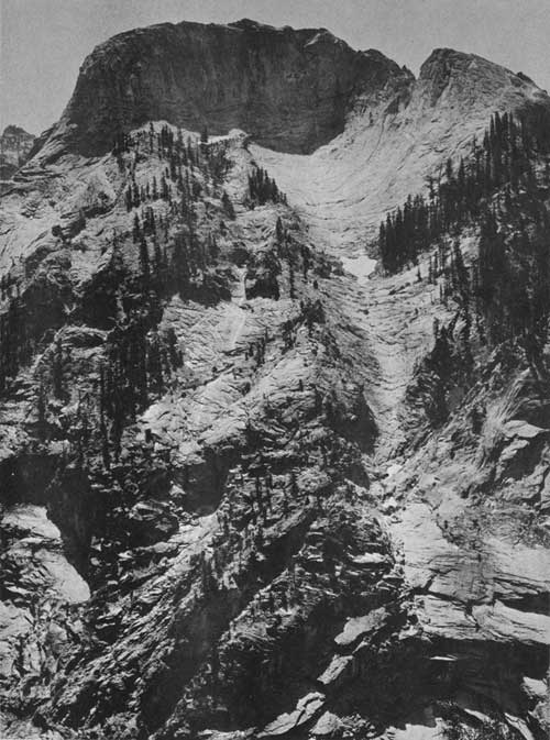
| The largest and most perfectly formed avalanche chute in Sequoia National Park, viewed from the High Sierra Trail east of camp in Bearpaw Meadow. Like its smaller companion, this chute is carved in massive exfoliating granite and terminates at the brink of the glacial U-shaped canyon below. The downward narrowing of the chute is explained by the protection given to the lower part of the chute by a snow cone on the surface of the glacier which lay in the canyon. |
| <<< Previous | <<< Contents >>> | Next >>> |
pp/504-A/foreword.htm
Last Updated: 03-Aug-2009