
|
Geological Survey Professional Paper 329
Reconnaissance of the Geomorphology and Glacial Geology of the San Joaquin Basin, Sierra Nevada California |
GEOGRAPHIC SKETCH
LOCATION AND EXTENT OF AREA
The San Joaquin Basin is one of the largest of the many basins on the west slope of the Sierra Nevada, whose rivers drain into the Great Valley of California (fig. 1). It lies immediately southeast of the scenic central part of the range, which is mostly in Yosemite National Park. In its outlines, the basin is roughly comparable to a wedge-shaped leaf (fig. 2). Broadest at the crest of the range, it narrows southwestward to a point at the foothills.

|
| FIGURE 2.—Drainage map of the San Joaquin Basin and surrounding region. (click on image for a PDF version) |
The most northerly point of the basin, near Agnew Pass (pl. 1), is at latitude 37°44'; its southernmost point, in the foothills below Friant, is at latitude 36°55'. The basin extends from longitude 118°39' at Mount Wallace westward to longitude 119°47' in the foothills west of the San Joaquin River.
The northwestern part of the basin lies in Madera County, the southeastern part in Fresno County. The San Joaquin River is the boundary between the two counties from the foothills to a point near the center of the basin; from this point the boundary extends northeastward in a straight line to the crest of the range. The entire basin is included in the Sierra National Forest save its southern foothills and the scenic area at the southeast corner of the basin which includes Evolution Valley, Evolution Basin, and Goddard Canyon, and their confining crests; these are parts of the Kings Canyon National Park.
On the northwest, the San Joaquin Basin adjoins the relatively small drainage basin of the Fresno River, which reaches only about half-way up the west slope of the Sierra Nevada. Above this, it adjoins the larger drainage basin of the Merced River, which extends all the way to the crest of the range. The San Joaquin Basin is walled off from the Merced Basin by a chain of lofty crests and peaks.
On the south the San Joaquin Basin borders the drainage basin of the Kings River, which is slightly smaller. The two basins are separated by a long line of serrate peaks which, toward the lower levels, give way to irregular, plateaulike uplands.
On the northeast—that is, at its extreme head, which is throughout determined by the main drainage divide on the crestline of the Sierra Nevada—the San Joaquin Basin abuts upon the east front of the range, which drains into Owens Valley and the lesser basins at its head, except for a short stretch at the extreme north end, which drains into the basin of Mono Lake.
From the crestline to the foothills the basin measures 65 miles in length; it is 54 miles wide, measured along the crestline of the range; and its area comprises 1,760 square miles. The outlines of the tract are fairly regular, the salients and indentations in its sides being for the most part small and roughly compensating. The only significant departure from the wedge shape, mentioned previously, is a projection 10 miles in length at the southeast corner.
DRAINAGE AND TOPOGRAPHY
The outlines of the San Joaquin Basin have been compared to those of a wedge-shaped leaf, and similarly the drainage lines may be likened in a general way to the venation of that leaf. The San Joaquin River, in its upper course known as the Middle Fork, forms the crooked midrib, running southwesterly. The North Fork extends up into the principal left lobe, at the north; the South Fork into the much larger right lobe, at the southeast; and other smaller tributaries each into a minor lobe.
Thus the San Joaquin River, like nearly all of the great master streams of the Sierra Nevada, pursues mainly a southwesterly course down the west slope and transverse to the crestline of the range. Most of its tributaries, on the other hand, pursue northwesterly or southeasterly courses, approximately at right angles to it and unaffected by the general southwestward slope of the range. The preponderance of these longitudinal elements in the drainage net will be apparent from a glance at the drainage map, figure 2.
The longest and most important of the longitudinal streams is the South Fork of the San Joaquin, which flows northwestward throughout its course save in the 3-mile stretch immediately above its junction with the Middle Fork, where it turns southwestward. The South Fork is 52 miles long—17 miles longer than the Middle Fork; for that reason and because of its greater volume, it might well be regarded as the true upper course of the master stream. Several of its tributaries have northwestward-trending courses, in whole or in part. Such are Evolution Creek, Piute Creek, and Bear Creek—the two last named flowing northwestward in their upper courses and then a right-angle turn to the southwest in their lower courses. Other tributaries of the San Joaquin that flow mainly in northwesterly directions are Kaiser Creek, Big Creek and its branch Tamarack Creek, Stevenson Creek, and Big Sandy Creek. Tributary to the Middle Fork is Fish Creek and its branch, Silver Creek.
Among the southeastward flowing streams are to be counted the upper course of the Middle Fork itself, from the vicinity of Agnew Pass to Pumice Flat; Minaret Creek, King Creek, the North Fork of the San Joaquin (which heads on Rogers Peak) and several of its tributaries; Granite Creek and its forks; Chiquito Creek and several of its tributaries; Rock Creek; and Willow Creek.
The above list includes all of the major affluents of the San Joaquin, with the exception of Jackass Creek and Fine Gold Creek, which flow mostly in southerly directions; but even these streams have long southeastward-trending stretches and branches, and taken as a whole, trend east of south rather than west of south.
The San Joaquin Basin reaches all the way from the foothills to the crestline, and has the full hypsometric range of the Sierra Nevada, which at this latitude is considerably more than 13,000 feet. The two extremes in altitude are the bed of the San Joaquin River at the foothills, 5 miles below Friant, which is only 285 feet above sea level, and the summit of Mount Humphreys, on the crestline, which attains 13,972 feet. A straight line drawn between these two points, which are 63 miles apart, slopes at an angle of 2°21', or at a mean rate of 217 feet to the mile (equivalent, approximately, to a 4 percent grade). This inclination is representative in a general way of the central part of the Sierra Nevada, and is intermediate between the slope of the northern part, which is only 1°24', or 128 feet to the mile (2.4 percent), and that of the culminating part, in the latitude of Sequoia National Park, which, measured from the foothills to the Great Western Divide, is 4°30', or 416 feet to the mile (7.9 percent).
Most of the mountain crests are on the upper slope of the San Joaquin Basin—that is, in the part commonly termed the "High Sierra." The middle slope is by contrast signally devoid of serrate crests, being predominantly a region of plateaulike uplands that have a general southwestward slant and bear scattered hills and knobs of moderate height. Less impressive scenically, but equally interesting to the student of landforms, are these undulating, billowy uplands, which aggregate about a hundred square miles in area. They are sharply trenched by the San Joaquin River and its main branches, which have cut impressive canyons more than 2,000 feet deep; but the upland surfaces themselves are drained by tributary streams which follow, mostly, broad shallow valleys. From the mouths of these valleys, the tributaries generally descend abruptly into the deep canyons, by cascades and even waterfalls. So characteristic of the region is this situation that the San Joaquin Basin might be termed a "land of hanging valleys." Though it does not possess an array of spectacular waterfalls such as distinguish the Yosemite region, it does have a wealth of beautiful cascades. In some places, as south and southeast of Shaver, the upland persists to within a few miles of the foothills and there breaks off in steep bluffs of considerable height. The foothill belt, again, contains short northwestward-trending ridges and detached mountains 1,000 to 1,500 feet high.
The mean inclination for the entire San Joaquin Basin is, however, considerably less than 2°21', for the crestline itself varies more than 4,700 feet in altitude. At one point, Minaret Pass (not marked on Mount Lyell quadrangle, but situated directly east of Pumice Flat, in the upper Middle Fork Canyon), the crest descends to an altitude of 9,200 feet. A line drawn from this lowest point on the main divide to the western foot of the range, slopes at an angle of only 1°35' or at a rate of 147 feet to the mile (2.8 percent). The mean inclination for the entire basin is probably not far from 1°54', or 174 feet to the mile (3.3 percent).
These figures, however, take no account of the actual configuration of the San Joaquin Basin, which is diversified by boldly sculptured, serrate mountain crests, plateaulike uplands, and deep valleys and canyons.
The mountain crests include a few that trend southwestward, down the slope of the Sierra Nevada, but most of them, including those that are especially prominent in the configuration of the basin, trend northwestward, parallel to the axis of the range and at right angles to the course of the San Joaquin River, thus interrupting and accidenting the general southwestward slope. These crests, ranging from 2,000 to more than 2,500 feet in height, rise high enough above the adjoining uplands and valleys to be called mountain ranges. The persistent trend of these crests has affected the arrangement of the tributary streams, which, as previously emphasized, show a remarkable tendency to flow in southeasterly or northwesterly directions, at right angles to the general direction of their master stream.
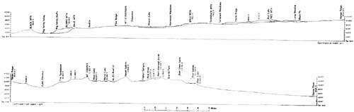
From the foregoing description it is evident that the San Joaquin Basin on the whole does not in any sense slope gradually and continuously down to the level of the Great Valley of California. It differs markedly in that respect from the more gently sloping northern parts of the Sierra Nevada which afford grades for railroads and highways. The configuration of the San Joaquin Basin is such that a person who would travel in a straight line from the main divide down to the foothills, instead of having a fairly continuous descent, would find himself obliged to make repeated arduous climbs and steep descents. The canyon of the San Joaquin is too rugged to serve as a convenient avenue for travel, and as a consequence, the main routes are on the uplands on either side of the canyon and over the transverse ridges. Some conception of the irregularities in the slope of the San Joaquin Basin may be gained from the profile in figure 3 which is plotted without vertical exaggeration.
|
| FIGURE 3.—Profile across Sierra Nevada, from Big Sandy Valley over Kaiser Ridge-Florence Lake-Mount Hooper-Seven Gables-Main Drainage Divide near Granite Park to Owens River. (click on image for a PDF version) |
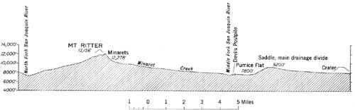
Among the topographic anomalies in the San Joaquin Basin one is especially noteworthy. This is the sag in the crestline of the range at Minaret Pass, a peculiar feature that differentiates the San Joaquin Basin from all other parts of the Sierra Nevada, except the basin of the Feather River near the northern end of the range. The pass is more than a mere notch in the otherwise remarkably continuous crest of the mountain block. It is a 5-mile stretch of low altitude that includes also Mammoth Pass (9,300 feet) at its southern end. Mammoth Mountain is an ancient volcano located in the middle part of the sag. The dwindling of the main drainage divide here is accentuated, moreover, by two other unusual circumstances: by the breaking down of the generally precipitous eastern escarpment of the Sierra Nevada in this section to a slope of moderate declivity only about 1,000 feet in height; and by the presence, 6 miles to the west, of one of the most impressive of the longitudinal crests, the Ritter Range, whose lofty summits, more than 12,000 and 13,000 feet in altitude, far overshadow the low and subdued main divide (fig. 4).
|
| FIGURE 4.—Profile extending from the canyon of the North Fork southeastward through Mount Ritter and across the crest of the Sierra Nevada. The profile, drawn without vertical exaggeration, emphasizes the anomalous lowness of the main drainage divide in this section as compared with the greatly superior altitude of the Ritter Range. (click on image for a PDF version) |
CLIMATIC CONDITIONS3
3This section has been based on the following sources: Erwin, 1934, p. 17-18; Matthes, 1930a, p. 10-11; Matthes, 1933a, p. 27-28; Russell 1938, p. 73-84; Russell, 1947, p. 323-340.
The San Joaquin Basin, being centrally situated in the Sierra Nevada, shares in the climatic conditions and life zones that are typical for the west slope of the range.
Like every other mountain range of great height and extent, the Sierra Nevada is itself a "climate maker"; that is, in large measure it is the author of its own weather conditions and controls those of the regions to the leeward. Lying parallel to the Pacific coast, it forms a barrier over which the vapor-laden winds that blow in from the ocean must rise. As they are forced up to high levels, they are chilled and discharge their condensed water vapor. This heavy precipitation on the Sierra Nevada explains the general barrenness of the Great Basin. The air currents are fairly wrung dry as they pass over the range.
About 18 percent of the total annual precipitation falls in autumn, about 53 percent in winter (mostly snow), 26 percent in spring, and less than 3 percent in summer.
Thus the summers are remarkably dry. Rainless periods of 2 or 3 months are the rule, though occasional thunderstorms may occur, especially in the High Sierra. Camping without tents is a common practice, and the higher parts of the range have such an enjoyable and healthful summer climate that they have become a mecca for vacation seekers.
Torrential rains are uncommon and floods on Sierra streams are generally the result of unusually rapid melting of snow, rather than of heavy rainfall. The Sierra is almost free of violent storms. Large windfalls of trees, such as result from gale-velocities, are comparatively rare.
The extreme heavy snowfall of the Sierra Nevada results from the coincidence of maximum precipitation with the season of lowest temperature—a coincidence that also explains the persistence of a deep snow cover until late spring or even later. Winter snows exceed those of any other part of the United States, except for the Olympic Mountains and the northern Cascade Range. According to United States Weather Bureau records, the annual snowfall at stations on the Southern Pacific Railroad, at altitudes between 6,000 and 7,000 feet on the west slope, aggregates 30 to 40 feet in depth. Records of more than 60 feet are fairly common above a 6,000-foot altitude. Snowfalls of 5 feet within 24 hours, and over 32 feet within a single month, have been reported. At Huntington Lake the depth of the snow cover in February and March, in some years, is nearly 10 feet, and from other localities depths almost twice as great have been reported.
The Sierra Nevada is not, of course, equally favored with moisture in all its parts. The annual precipitation increases with elevation, on the western slope, at rates varying from 0.75 to 1.33 inclines for each 100 feet of vertical ascent, up to altitudes of 5,000 to 6,500 feet, above which the rate slightly decreases. Thus the bulk of rain and snow falls on the middle part of the west slope, and the foothills and lower slope partake in large measure of the semiarid conditions that prevail in the Great Valley. The higher peaks and crests above the forest zones are also relatively dry, the air currents having discharged most of their content of water vapor before reaching those heights. The High Sierra, it is true, retains its snow cover much longer in spring and summer than the middle slope, but that is due primarily to the lingering cold. The east front of the range also is arid compared with the west slope.
From altitudes of 11,000 feet upward, the precipitation, even in summer, consists largely of snow or hail, and the temperature in the shade seldom rises much above the freezing point. Snowdrifts abound until far into midsummer, and perennial bodies of old, hard snow and even a few small glaciers occupy the shaded, steep-walled recesses among the higher peaks.
LIFE ZONES AND VEGETATION
The unequal distribution of snow and rain on the Sierra Nevada, together with the wide range in temperature from the torrid foothills to the wintry crest, give rise to several distinct climatic belts or zones, each of which has its characteristic forms of vegetation and animal life (Matthes, 1930a, p. 10-11; 1933a, p. 28-29). These zones are broadest and most distinct on the west slope of the range, and are readily recognized when one ascends the San Joaquin Basin.
The semiarid foothill belt, hot and dry in the summer but rainy in the winter, corresponds to what biologists term the "Upper Sonoran life zone." Its vegetation consists characteristically of thin grass, bushy chaparral (an aggregate of small-leaved bushes among which the red-stemmed manzanita (Arctostaphylos) is especially prominent), scattered evergreen oaks, and digger pine (Pinus sabiniana).
Toward the 3,000-foot level this vegetation becomes denser and finally merges with the majestic forests of the Transition life zone. Here flourish the yellow pine (Pinus ponderosa), the Jeffrey pine (Pinus jeffreyi), the sugar pine (Pinus lambertiana), the incense cedar (Libocedrus decurrens), the white fir (Abies concolor), and the Douglas fir (Pseudotsuga taxifolia), all valuable lumber trees attaining great size and height. Dispersed among them, in groups or groves, stand the "big trees" (Sequoia gigantea), but no groves of this species have been reported from the San Joaquin Basin, though the Fresno Grove and the celebrated Mariposa Grove lie just north of its boundaries and the McKinley (Dinkey) Grove just south of them, (Sudworth, 1908 and Jepson, 1910).
The Canadian life zone, from 7,000 to 9,000 feet in altitude, is characterized by large stands of lodgepole pine (Pinus murrayana) and groves of white fir and red fir (Abies magnifica). Between altitudes of 9,000 and 11,000 feet is the Hudsonian life zone, in which only the hardiest species of trees can thrive. The distinctive trees of this zone are the western white pine (Pinus monticola), the alpine hemlock (Tsuga mertensiana) and the white-bark pine (Pinus albicaulis), which grows in curiously storm-twisted, recumbent, and even prostrate forms up to the extreme timberline. Above this line, in the Alpine life zone, the mountain sides and peaks rise apparently barren of vegetation, but actually even here there is a surprising wealth of small plants, many of which bear brightly colored flowers.
ECONOMIC AND SOCIAL USE
All of the San Joaquin Basin, except the southwestern foothill section and the Evolution Valley region, is included in the Sierra National Forest. The basin is of great importance for its water resources and as a recreational, lumbering, and grazing area. Most of the information in this section was furnished by the Office of the Supervisor, Sierra National Forest, Northfork, California. Maps of the Sierra National Forest, available from the Forest Service on scales of both one-quarter and one-half inch to the mile, show most of the features mentioned.
Within recent decades, mainly since this reconnaissance was made, a remarkable development of human activities, both economic and social, has taken place in the basin. Hydroelectric power is now being generated on a large scale. The hydroelectric development of the Southern California Edison Co., which utilizes the Shaver Lake, Huntington Lake, and Lake Florence reservoirs (fig. 2) is the largest project of this company, and is reputed to represent a total outlay exceeding the cost of the Panama Canal. Crane Valley Lake and Kerckhoff Lake serve a project of the Pacific Gas and Electric Co. Work in progress, leading to the construction of new plants, is also increasing the outlay of existing plants by adding to present storage facilities.
The entire flow of the San Joaquin River is being utilized for downstream irrigation in the highly productive San Joaquin Valley. Average annual runoff is close to 1-1/2 million acre-feet, all covered by downstream water rights. At Friant (see Friant quadrangle), just outside the Sierra National Forest, is Millerton Lake (fig. 2), which is formed by Friant Dam, a part of the Central Valley irrigation project of the U.S. Department of the Interior.
The building of roads in connection with these projects has opened to the public a large area of rugged, mostly forested mountain country at lower and middle altitudes, that was previously inaccessible except by steep rough trails. There has followed a great influx of vacationists whose numbers have grown as opportunities for recreation have increased. During the 1949 season there were about 990,000 recreational visitors to that part of the Sierra National Forest within the drainage of the San Joaquin River.
The San Joaquin Basin, although on the whole less notable for its mountain scenery than the Yosemite region to the north, and less deeply gashed by canyons than the Kings River Basin to the south, nevertheless includes some of the finest alpine scenery in the Sierra Nevada. The extreme southeastern corner of the basin, embracing Evolution Valley and Basin, and Goddard Canyon, is included in Kings Canyon National Park, established by act of Congress on May 4, 1940.
The Forest Service, in order to preserve the wilderness state of typical mountain and forest areas, has set apart a number of tracts of national forest land that will be left in their natural condition, without roads and other permanent recreational developments. Two such areas have been established in the Sierra National Forest, and both include extensive parts of the San Joaquin Basin. The Dana—Minarets Wild area, of 87,140 acres, lies immediately north and northwest of the Devils Postpile National Monument. The High Sierra Wilderness Area, of 393,945 acres, extends along the crest of the range from the Mammoth Lakes southward to the Kings Canyon National Park. Through these wilderness areas passes the famous John Muir Trail in its course from Tuolumne Meadows, in Yosemite National Park, to Mount Whitney, in Sequoia National Park (Starr, 1953). Mountaineering enthusiasts who visit the upper San Joaquin Basin over this trail or its approaches, afoot with knapsack, or on horseback with packtrains, make excursions from their basecamps into the surrounding areas, and climb peaks of the Evolution group, the Ritter Range, and other alpine sections of the High Sierra (Voge, 1954).
An area of 39,000 acres which almost surrounds Huntington Lake and lies mostly to the north of that lake, was designated the Huntington Lake State Game Refuge in 1931. In this area, set aside for the protection and propagation of wild life, firearms may not be discharged for any reason.
The Devils Postpile National Monument, justly celebrated for its remarkable development of columnar structure in basalt (Matthes, 1930b), brings visitors into the otherwise little frequented country in the Middle Fork Canyon of the San Joaquin River. This monument, administered by the Superintendent of Yosemite National Park, lies at an elevation of 7,000 to 8,000 feet, is about 2-1/2 miles long and 1/2 mile wide, and has an area of 798-1/2 acres.
Mineralization has occurred in the metamorphic rocks of both the foothills zone (Macdonald, 1941, p. 267-270) and the Minaret mining district, in the Ritter Range region at the north end of the San Joaquin Basin (Erwin, 1934, p. 10-11, 61-78), but there has been virtually no mineral production of significance. The Minaret district, in particular, has been extensively prospected, and ore bodies have been found containing iron, lead, zinc, copper, and silver, as well as minor amounts of molybdenum, tungsten, and bismuth. On the upper slope of Iron Mountain, in this district, is a body of magnetite that has long attracted the attention of miners and that possibly would be profitable to exploit if it were more accessible to roads and markets.
The notable economic and social developments, together with the increasingly great popular interest in the San Joaquin Basin, give added interest to the geomorphological features which are described and interpreted in this report.
| <<< Previous | <<< Contents >>> | Next >>> |
pp/329/sec1.htm
Last Updated: 27-Jul-2009