
|
Geological Survey Professional Paper 1356
Neogene Tectonics and Geomorphology of the Eastern Uinta Mountains in Utah, Colorado, and Wyoming |
RANDOM RELATIONSHIP OF THE BROWNS PARK FORMATION TO THE GILBERT PEAK EROSION SURFACE
Bradley (1936) was first to evaluate the relationship of the Browns Park Formation to the Gilbert Peak erosion surface, largely refuting the earlier conclusions of Sears (1924a), who later acceded to Bradley's view. As will be shown, this relationship provides further evidence of the disparate ages of the Browns Park Formation and the Bishop Conglomerate. It now appears that Sears was correct in identifying as Bishop the conglomerate beneath the Browns Park Formation in the Dry Mountain—Sand Wash—Little Snake River area but was incorrect in concluding that it also was a basal conglomerate of the Browns Park.
Bradley (1936) did not believe that the conglomerate beneath the Browns Park Formation was the Bishop, nor that the underlying pediment was the Gilbert Peak surface. Specifically, he believed that the pediment remnant preserved on Bear Mountain was part of a regional erosion surface (the "Bear Mountain erosion surface") which passed eastward beneath Browns Park and was lower and distinctly younger than the Gilbert Peak surface. He also supposed that the Browns Park Formation was deposited on this surface shortly after the surface formed, and that the conglomerate underlying the Browns Park was the basal unit of that formation. Remnants of a surface that Bradley correlated with his Bear Mountain surface are plentiful in the southwestern part of the Green River Basin of Wyoming; they generally lie 120-150 m below the Gilbert Peak erosion surface and 60-90 m above modern drainage, and they are capped with gravel but lack the covering white sand of the typical Browns Park (Bradley, 1936, p. 180). Bradley considered the gravel on these remnants to be a basal conglomerate of the Browns Park Formation, but such a correlation—between dissimilar deposits many kilometers apart—is tenuous in the absence of typical Browns Park material. In all probability, the gravel on those outlying remnants is Pleistocene or late Pliocene.
I regard the two surfaces—Gilbert Peak and type Bear Mountain—as one, displaced by faulting, for the following reasons:
1. In its type area, the Bear Mountain surface at Bear Mountain and Dutch John Bench is separated from the Gilbert Peak surface at Goslin Mountain by faulting.
2. Berm-like remnants or outliers of the Gilbert Peak surface might be expected to remain between Bear Mountain and the crest of the range if the Bear Mountain surface were younger and lower than the Gilbert Peak surface.
3. The Bear Mountain surface as mapped by Bradley is everywhere capped by younger deposits, except at the type locality, where it and the adjacent Gilbert Peak surface are both bare bedrock.
4. The type Bear Mountain surface rises and merges gradually westward with the type Gilbert Peak surface (Bradley, 1936, fig. 16).
5. At Red Canyon, the type Bear Mountain surface is 360-550 m above modern drainage and stands tens to hundreds of meters above remnants of the Browns Park Formation, which fill swales and valleys cut into the surface. Gravel-capped remnants that Bradley correlated with the surface in southwestern Wyoming are only 60-90 m above modern drainage. The type surface was deeply dissected before the Browns Park Formation was deposited, and a long period of time, therefore, intervened.
6. The type Bear Mountain surface, like the Gilbert Peak surface, projects high above the head of Browns Park, rather than passing beneath it as Bradley supposed.
7. Time constraints argue against the development of a local but broad surface cut into hard rock and intermediate in age between the Bishop Conglomerate and the Browns Park Formation. A long time interval had to elapse (a) during pedimentation, (b) during subsequent dissection of the pediment, and (c) before deposition of the Browns Park Formation across the dissected topography.
8. There is only one extensive subsummit pediment in the Eastern Uinta Mountains, just as there is only one elsewhere in the Southern Rocky Mountains of Colorado (Epis and Chapin, 1975; Epis and others, 1980).
The random relationship of the Browns Park Formation to the Gilbert Peak surface is even more evident in the valley of Browns Park (fig. 23). There the Gilbert Peak erosion surface forms the broad summits of the several high mesas (Goslin Mountain, Mountain Home in part, Head of Cottonwood, Bender Mountain in part, O-Wi-Yu-Kuts Mountain, and Cold Spring Mountain; all on fig. 27) that border the valley and stand 300-600 m above the valley floor. Filling the valley bottom, the Browns Park Formation laps against the lower slopes and spurs of these mesas in depositional contact with the Uinta Mountain Group (into which the mesas and the valley subfloor are carved) and extends into side valleys cut by post-Gilbert Peak erosion. The contact of the Browns Park Formation with the Uinta Mountain Group is discontinuously faulted along the northeast side of the valley by post-Browns Park movements on older faults (Hansen, 1965, plate 1; also fig. 27, this report), but the old hard-rock floor of the valley was formed chiefly by erosion along the axis of the Uinta anticline long after the Gilbert Peak erosion surface had formed. Later valley erosion was guided by warping and faulting before deposition of the Browns Park Formation.
|
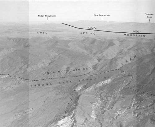
| FIGURE 23.—Aerial view over Browns Park looking north across the Gilbert Peak erosion surface on Cold Spring Mountain, in middle distance, toward Pine (Bishop) Mountain, flecked with snow drifts on skyline. Browns Park Formation in the foreground, 760 m below top of Cold Spring Mountain, is in depositional contact with the Uinta Mountain Group. Note how the Browns Park Formation extends into Spitzie Draw, indicating that the draw—which obviously is younger than the Gilbert Peak erosion surface—is older than the Browns Park Formation, though modified by post-Browns Park erosion. Pine Mountain on the skyline is capped with Bishop Conglomerate (the type locality). The Uinta fault passes between Pine Mountain and Cold Spring Mountain. |
In many places along the north side of Browns Park the Gilbert Peak erosion surface is tilted southward toward the valley, opposite its original slope. This tilting created new south-flowing drainages. Earlier, when the Bishop Conglomerate was accumulating, the site of Browns Park must have been a mountainous source of detritus for the conglomerate now exposed in the broad area to the north. The Gilbert Peak surface stretched northward from these mountains. The reversal of topography came later, following pedimentation, faulting, and foundering of the Uinta arch, before the Browns Park Formation was deposited, and the resulting trough provided a natural stilling basin for the accumulation and preservation of the gravels, sands, tuffs, and clays of the Browns Park Formation (Hansen, 1965, p. 129-130).
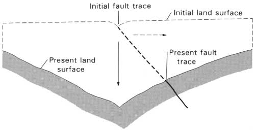
The extent of faulting beneath Browns Park is obscured by the Browns Park Formation and hence is unknown, but it probably is considerable, if the abundance of faults in the valley margin is indicative. Some of these faults cut the Browns Park Formation, but most of them pass beneath it. The course of drainage through Browns Park surely was influenced by such faults. A drainage line controlled initially by a fault line need not coincide with the present trace of the fault if the fault has an appreciable dip. As the land surface is lowered by degradation, the fault trace shifts laterally, whereas the drainage is prone to cut vertically downward (fig. 24). Examples of this principle are common in the West.
|
| FIGURE 24.—Diagram showing how the trace of a dipping fault that initially controlled the position of a drainage line can shift away from that line during degradation. As the drainage cuts vertically downward (solid arrow) the fault trace shifts laterally (dashed arrow). |
Although Bradley (1936, fig. 16) had thought it flat, the hard-rock subfloor of the old Browns Park valley apparently is canyonlike. In general its deepest part is well north of the present valley bottom, probably near the axis of the Browns Park syncline, which formed partly by differential compaction of the thick sedimentary prism. At Swallow Canyon the Green River now impinges on the south wall of the old valley, forming a superimposed trench cut into the Uinta Mountain Group through a once-buried spur—Kings Point—which has been exhumed and incised. The summit of the spur, 200 m above the river, must have once been covered by the Browns Park Formation. The buried axis of the old valley lies far to the north.
Just north of the Gates of Lodore, outcrops of the Uinta Mountain group limit the position of the old valley bottom to a zone less than 2.4 km wide. There the present valley bottom has an elevation of about 1,630 m, but drill-hole data indicate that the hard-rock floor just to the north is at least 180 m deeper (S. J. Luft, U.S. Geological Survey, written commun., 1980). The buried-valley profile north of the Gates must have sloping sides of at least 10-12 degrees.
It thus is evident that the Browns Park Formation, unlike the Bishop Conglomerate, had no genetic relationship to regional pedimentation in the eastern Uinta Mountains in general or to the Gilbert Peak surface in particular. The Browns Park Formation filled valleys narrow and wide, buried hills and spurs of mountains, and spread out locally over broad areas. In the Boone Draw—Maybell—Lay area, it was deposited across the Bishop Conglomerate after the conglomerate and the subjacent Gilbert Peak erosion surface both had been partly dissected and had been greatly depressed by pre-Browns Park regional warping; locally, the Bishop was completely removed before the Browns Park was deposited. In the lowest part of its old valley, between Simsberry Draw and Juniper Mountain (fig. 13), the Browns Park has its own basal conglomerate of material carried out of the Park Range by an ancestral drainage of the Yampa valley. On the other hand, where the Bishop remained above the general depositional level, the Browns Park Formation accumulated in depressions topographically lower than the Bishop, some much lower.
I know of only one locality in the eastern Uinta Mountains where the Browns Park Formation rests with apparent conformity on a well-defined but local remnant of a pediment. That locality is in Moffat County just north of Irish Canyon (fig. 42) in T. 10-11 N., R. 101 W. Both Sears (1924a, p. 292) and Bradley (1936, p. 181-182) described it in some detail because of its relationship to Cold Spring Mountain and the Uinta-Sparks fault zone. Bradley used this relationship to refute the equivalence of the Bishop Conglomerate and the basal conglomerate of the Browns Park Formation. A berm-like remnant of a pediment, which Bradley identified as the Bear Mountain surface, cuts into the flank of Cold Spring Mountain about 300 m below the summit. The berm is capped with a cobbly conglomerate, about 15 m thick, made mostly of limestone cobbles and occasional small boulders in a coarse, poorly sorted sandstone matrix. The limestone plainly came from the nearby outcrops of Limestone Ridge along the north side of Cold Spring Mountain. Cobbles of red quartzite from the Uinta Mountains Group are subordinate—just a few percent. The conglomerate passes beneath typical white sandstone of the Browns Park Formation and slopes eastward toward Vermillion Creek. Although Sears correlated this conglomerate with the Bishop, it differs markedly from nearby Bishop Conglomerate in thickness, lithology, and texture, and is, in fact, a local basal facies of the Browns Park Formation. On nearby Pine Mountain and Diamond Peak the Bishop stands 600 m higher, is nearly 60 m thick (Roehler, 1972a, b), and consists mostly of red quartzite clasts, some very large.
| <<< Previous | <<< Contents >>> | Next >>> |
pp/1356/sec7.htm
Last Updated: 09-Nov-2009