
|
Geological Survey Professional Paper 1356
Neogene Tectonics and Geomorphology of the Eastern Uinta Mountains in Utah, Colorado, and Wyoming |
ABSTRACT
NEOGENE TECTONICS AND GEOMORPHOLOGY
OF THE EASTERN UINTA MOUNTAINS IN UTAH, COLORADO, AND WYOMING
By WALLACE R. HANSEN
A recent reevaluation of the Bishop Conglomerate in the Eastern Uinta Mountains region helps clarify how the conglomerate relates to the Browns Park Formation and, in turn, how both formations relate to middle Tertiary tectonic activity and late Tertiary and Quaternary drainage adjustments. Field relations indicate widely divergent histories for the two formations: They are separated in their type areas by great topographic discontinuity, but east of the Uinta Mountains, between Cross Mountain and Maybell, Colo., the Browns Park lies directly on the Bishop.
The Bishop Conglomerate is roughly coextensive with the subjacent Gilbert Peak erosion surface; the Bishop was deposited on this broad pediment soon after the surface formed, perhaps while the surface was still forming. In many places, however, mountainward parts of the surface are bare rock. These places and the adjacent mountains were the sources of the conglomerate. The site of Browns Park, which lies in the axial region of the Uinta anticline, was part of the crest of the Uinta Mountains when the Gilbert Peak surface was forming.
On the high proximal margins of the pediment, especially on the south slope of the range, headward parts of the surface penetrate deep into the range as flat-bottomed, alluviated remnants of dendritic valleys. Basinward, these valleys coalesced, and at one time they must have formed a continuous bajada around the north, east, and south margins of the range. A long period of crustal stability was needed to develop so broad and uniform a plain.
Nearly flat to rolling uplands 180 m or more above the Gilbert Peak surface and the Bishop Conglomerate at various places in the Eastern Uinta Mountains are regarded as remnants of a truncation surface higher and older than the Gilbert Peak surface. Remnants of this surface, here called the Wild Mountain upland surface, are preserved on Wild, Diamond, Douglas, Blue, and Cross Mountains and perhaps on summits farther west. They consist of resistant bare rock, and they truncate subjacent formations without regard for rock structure. The Wild Mountain upland surface probably is Eocene in age. It probably formed in the mountains while the thick Eocene alluvial and lacustrine deposits of the Wasatch, Green River, Bridger, and Uinta Formations were accumulating in the adjacent basins.
|
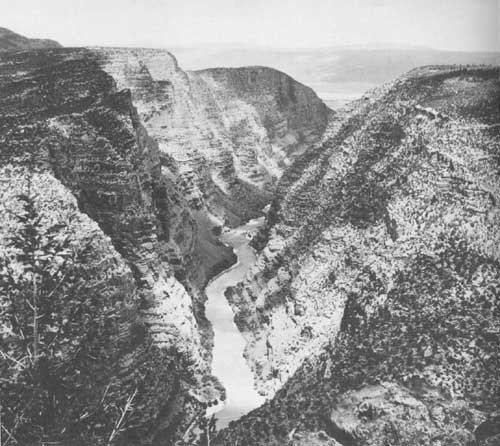
| FRONTISPIECE.—View north up Lodore Canyon toward Browns Park from rim of Douglas Mountain, showing downward steepening of the cross-canyon profile 245-300 m above river level, presumably caused by Pleistocene reentrenchment of the Green River. Canyon here is about 700 m deep. Even-topped Cold Spring Mountain is on distant skyline, below Diamond Peak at upper right. |
The Gilbert Peak erosion surface is regarded as Oligocene. Biotite and hornblende separates from tuffs high in the superjacent Bishop Conglomerate have recently been dated by the K-Ar method at 29 m.y. (Oligocene). These tuffs overlie most of the coarse conglomerate, but they are interbedded with and overlain by loose, poorly sorted pebbly sandstone that resembles some sandstone in the Browns Park Formation. This similarity has led to past correlations of Bishop with Browns Park in the Eastern Uinta Mountains. Some part of this sandstone sequence might be equivalent to the Browns Park Formation, but differing physical properties suggest that it is not.
With Laramide uplift of the Uinta Mountains, initial drainage was away from the mountains, and coarse orogenic deposits accumulated at the flanks. By middle Eocene time, however, during deposition of the Laney and Parachute Creek Members of the Green River Formation, a hydraulic connection probably existed between Lake Gosiute, on the north side of the range, and Lake Uinta, on the south side, as suggested by several workers, but the connection was blocked by the rise of the Axial Basin anticline at the end of Eocene time. The Gilbert Peak erosion surface was cut only after strong orogenic and epeirogenic uplift had warped the floors of the Tertiary basins enough to produce slope gradients sufficient to start erosion and pedimentation. From a late Eocene height of about 300 m above sea level, the basin floors rose to about 1,200 m by middle Oligocene time, at a rate of about 20 cm per thousand years. The mountains were perhaps 3,000-3,700 m above sea level. At that time, the Green River Basin probably had an outlet east toward the North Platte River.
Renewed deformation, beginning in late Oligocene time, terminated deposition of the Bishop Conglomerate and initiated far-reaching drainage changes. The south flank and the crest of the Eastern Uinta Mountains were tilted northward at a rate of about 28 m/km, lowering the crest about 1.6 km and reversing the directions of streams that formerly flowed south; the tilting also had an easterly component of about 9-11?? m/km. The north flank was warped and tilted to varied attitudes, mainly by movements of blocks between the Uinta-Sparks fault zone and another fault zone along the north and northeast sides of Red Canyon and Browns Park. Much of this tilting was southward. The inward tilting of both flanks triggered eastward drainage through the Red Canyon—Browns Park area along the future course of the Green River. As a result of tilting and warping, the Gilbert Peak erosion surface was lowered 520-975 m on the north flank by gravitative movement along the Uinta fault. New tributary drainage on the north flank was directed south where previous drainage had flowed north.
Meanwhile, subsidence in the easternmost Uintas and the western part of Axial Basin lowered the Bishop Conglomerate sufficiently over wide areas to produce a topographic and structural trough in which the Browns Park Formation soon began to accumulate. In that area the Browns Park Formation was deposited directly on the subsided Bishop, but in other places, such as Red Canyon and Browns Park, it accumulated in canyons and valleys tens to hundreds of meters below nearby Gilbert Peak and Bishop remnants. Regionally, the Browns Park Formation thus has a random relationship to the Bishop Conglomerate. Deformation continued during and after the deposition of the Browns Park Formation, but at a reduced and diminishing rate. Most of the tributaries of the Green River downstream from Flaming Gorge were essentially in their present courses before the Browns Park Formation was deposited.
The Browns Park Formation continued to accumulate in Browns Park until the old valley was overtopped at the site of Lodore Canyon in late Miocene or early Pliocene time. This concept calls for a much-thickened Browns Park Formation, but the evidence seems irrefutable. Drainage that had flowed toward the downwarp at the east end of the Uintas now spilled south toward the Uinta Basin, eroding through the Bishop Conglomerate on the south flank of the range and superimposing itself into the underlying older rocks, where it ultimately cut its canyons. Because of the wide distribution of the Bishop on the rims of the canyons, there can be no doubt that the drainage was superimposed through it. Upstream, drainage reinvigorated by its diversion to a steeper course to the Uinta Basin, eroded rapidly downward and headward, eventually capturing all the runoff of the Green River Basin.
Drainage, meanwhile, was evolving in the Yampa River area. Like the course of the Green, the course of the Yampa in the Uinta Mountains is younger than the Bishop Conglomerate. Upstream from the Uinta Mountains, however, an ancestral Yampa River was transporting pebbly gravel from the Park Range into the Lay—Maybell area before the main body of the Browns Park Formation was deposited. This gravel is the true basal conglomerate of the Browns Park Formation, and it is younger than the Bishop Conglomerate. With the tectonic subsidence of the Eastern Uinta Mountains following deposition of the Bishop, the Lay—Maybell—Browns Park area became a stilling basin for the accumulation of the dominantly fine-grained lacustrine and eolian deposits of the Browns Park Formation. These deposits probably had varied sources, but much of the sand might have come from the Bishop, winnowed out by deflation. The abundant tuffs of the Browns Park Formation probably came from volcanic centers far to the west.
Drainage through the Yampa Canyon area must have existed when the basal conglomerate of the Browns Park Formation was accumulating, but the canyon at that time was shallow and juvenile. The canyon deepened later when runoff was reinvigorated; the time of this deepening can only be surmised, but downcutting and entrenchment would have been greatly enhanced by the spillover of the Green River into Lodore Canyon and the resultant rejuvenation of the drainage system. The present course of the Yampa through Cross Mountain Canyon and Juniper Canyon is an accident of superimposition following deposition of the Browns Park Formation, as first postulated by E. T. Hancock many years ago.
The most significant postulated drainage change in the Uinta region, in terms of the total budget of the streams involved, and probably also the most recent, was the diversion of the Upper Green River from an ancestral easterly course across the Rock Springs uplift in middle Pleistocene time. The river was flowing about 200 m above its present level at Green River, Wyo., at that time and only about 210 m lower than the present Continental Divide at Tipton, Wyo. Some post-diversion uplift of the Continental Divide, therefore, is required—warping up to the east at a rate of about 1.8 m/km, or about 3.1 mm/km/103 yrs. Similarly, the Continental Divide at Tipton, since the postulated diversion, has risen at a rate of about 475 mm/103 yrs).
Canyon profiles in the Uinta Mountains indicate reentrenchment of the Green River since the initial cutting of its canyons. Downcutting had slowed, and the river had begun to widen the valley floor after Lodore Canyon was cut to a depth of about 460 m. Rejuvenated, the river then cut an additional 245-300 m to its present level. Cross-canyon profiles now show a downward-steepening slope break about 245-300 m above the river. Regional uplift, perhaps in response to unloading, could have rejuvenated the entire drainage system through the mountains, or the capture of the Upper Green River in middle Pleistocene time could have caused reentrenchment by greatly increasing the discharge and competence of the system. Both uplift and capture may have been involved. Continued episodic downcutting and presumed uplift are indicated by Quaternary terraces.
| <<< Previous | <<< Contents >>> | Next >>> |
pp/1356/abstract.htm
Last Updated: 09-Nov-2009