
|
Geological Survey Professional Paper 132—A
Rock Formations in the Colorado Plateau of Southeastern Utah and Northern Arizona |
SHORTER CONTRIBUTIONS TO GENERAL GEOLOGY, 1923.
ROCK FORMATIONS IN THE COLORADO PLATEAU OF SOUTHEASTERN UTAH AND NORTHERN ARIZONA.
By C. R. LONGWELL, H. D. MISER, R. C. MOORE, KIRK BRYAN, and SIDNEY PAIGE.
NATURE AND PURPOSE OF THE INVESTIGATION.
The field work of which this report is a record was done in the summer and fall of 1921 by members of the United States Geological Survey. A project to build a large storage dam at Lees Ferry, on Colorado River in northern Arizona, called for a detailed topographic survey of the area covered by the project, for the purpose of determining the capacity of the reservoir. This work was undertaken by the United States Geological Survey in cooperation with the Southern California Edison Co. Three surveying parties were sent to the field, each accompanied by a geologist, whose specific duty was to study and report on the rock formations within the area to be flooded.
One topographic party, under A. T. Fowler, which started at Lees Ferry and worked up stream in Arizona, was accompanied by Kirk Bryan. Another party, under K. W. Trimble, which started near Bluff and worked down the San Juan and thence down the Colorado, was accompanied by H. D. Miser. The third party, under W. R. Chenoweth, worked from Fremont River to the Waterpocket Fold and then returned to Green River, Utah, and traversed Cataract Canyon during the period of low water. C. R. Longwell was with this party until September, when his place was taken by Sidney Paige. Mr. Paige, in company with the Kolb brothers, E. C. La Rue, and Henry Ranch, left the Chenoweth party after Cataract Canyon had been surveyed and rowed down the Colorado to the mouth of the San Juan, where they were joined by Mr. Miser. Then they took a hurried trip by boat down the Colorado to Lees Ferry, making a few short stops and visiting the famous Rainbow Bridge.
Thus the geology of the canyons of Colorado and San Juan rivers and of the lower parts of tributary canyons was examined continuously, and reconnaissance work was done in the country back from the rivers. At the same time a fourth party, under R. C. Moore, was mapping parts of Kane, Garfield, and Wayne counties, Utah, to determine whether oil might be found there.
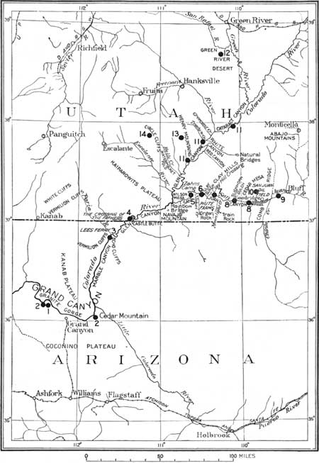
The present paper includes brief descriptions of the rocks of the regions traversed, detailed geologic sections, and columnar sections measured not only by the geologists who accompanied these parties but by other geologists who have worked in the same regions or in adjoining regions. The positions of the columnar sections measured and many of the other sections are shown on Figure 1.
|
| FIGURE 1.—Index map of parts of Utah and Arizona showing location of columnar sections (numbered dots) given in Plates I and II. Nos. 1 to 10 are given in Plate I; Nos. 11 to 14 in Plate II. I(click on image for a PDF version) |
PREVIOUS WORK.
The first geologic work done in the area here considered was that recorded in the report of the Macomb expedition of 1859 by J. S. Newberry,1 who examined the Mesozoic formations near Bluff. Next followed J. W. Powell's historic explorations in 1869 to 1872, which contributed some geologic information, although their most valuable results were geographic.2
1Newberry, J. S., Geological report, in Report of the exploring expedition from Santa Fe, N. Mex., to the junction of the Grand and Green rivers of the Great Colorado of the West, in 1859, under the command of Capt. J. N. Macomb, pp. 101-109, 1876.
2Powell, J. W., Exploration of the Colorado River of the West, 1875.
G. K. Gilbert's work in 1875 and 1876 was necessarily of a reconnaissance nature, but it showed powers of observation and interpretation that have aroused the admiration of later workers who have used his report3 as a guide. W. H. Holmes contributed information on the San Juan district,4 in a report on field work that was in part contemporaneous with that done by Gilbert farther north and west. The classic reports of Gilbert and Holmes served all practical needs for a knowledge of this sparsely settled region until oil was discovered at Goodridge in 1908. H. E. Gregory5 and E. G. Woodruff6 made reports on the geology of the oil field, and Gregory later, in his reports on the Navajo country,7 described the geology of the region on the south side of the San Juan. The most recent papers of direct interest in the present connection are those by W. B. Emery,8 C. L. Dake,9 Dorsey Hager,10 C. T. Lupton,11 and R. C. Moore.12 Numerous papers on adjacent areas, herein referred to, have been of great assistance in making correlations.
3Gilbert, G. K., Report on the geology of the Henry Mountains, U. S. Geog. and Geol. Survey Rocky Mtn. Region, 1880.
4 Holmes, W. H., Geological report on the San Juan district: U. S. Geog. and Geol. Survey Terr. Ninth Ann. Rept., for 1875, pp. 237-276, 1877.
5 Gregory, H. E., The San Juan oil field, Utah: U. S. Geol. Survey Bull. 431, pp. 11-25, 1911.
6 Woodruff, E. G., Geology of the San Juan oil field, Utah: U. S. Geol. Survey Bull. 471, pp. 76-104, 1912.
7 Gregory, H. E., The Navajo country: U. S. Geol. Survey Water-Supply Paper 380, 1916; Geology of the Navajo country: U. S. Geol. Survey Prof. Paper 80, 1917.
8 Emery, W. B., The Green River Desert section, Utah: Am. Jour. Sci., 4th ser., vol. 46, pp. 551-577, 1918.
9 Dake, C. L., The pre-Moenkopi unconformity of the Colorado Plateau: Jour. Geology, vol. 27, pp. 61-74, 1920; Horizon of the marine Jurassic of Utah: Jour. Geology, vol. 27, pp. 634-646, 1919.
10 Hager, Dorsey, Oil possibilities of the Holbrook area in northeast Arizona, 1921. A private publication.
11 Lupton, C. T., Geology and coal resources of Castle Valley, Utah: U. S. Geol. Survey Bull. 628, 1916.
12 Moore, R. C., On the stratigraphy of northeastern Arizona: Am. Assoc. Petroleum Geologists Bull., vol. 6, No. 1, pp. 47-49, 1922. Discusses paper by Hager cited above.
TOPOGRAPHY.
The area considered in this report is part of a large arid region that is sparsely settled and difficult of access. It is a typical portion of the Colorado Plateau, characterized by canyons, cliffs, mesas, and buttes. The general plateau surface, averaging between 5,000 and 6,000 feet in altitude, appears fairly regular and continuous in a panoramic view; but Colorado River and its tributaries have cut hundreds of feet below the general level, and Navajo Mountain and the Henry Mountains project conspicuously above it, attaining maximum altitudes of about 11,000 feet. The Henry Mountains are classic as the type locality of the igneous intrusive masses known as laccoliths. Northwest of these mountains are the so-called High Plateaus, lofty forest-clad table-lands with gently irregular surface topography and precipitous borders, which have an average altitude of more than 9,000 feet.
Alternating sedimentary formations of varying, resistance exert a strong topographic control. Heavy sandstone and limestone units form vertical cliffs or level mesa tops; shales produce slopes or local areas of badlands. Stream courses cut into sandstone or limestone are confined in narrow, steep-walled canyons; but at horizons of thick shales the valleys are wide, with vertical outer walls made by the overlying sandstones. Typical cross sections of the larger streams show prominent structural terraces or benches, which mark abrupt changes in the character of the rocks.
| <<< Previous | <<< Contents >>> | Next >>> |
pp/132-A/sec1.htm
Last Updated: 08-Aug-2008