
|
Geological Survey
Geologic Setting of the John Day Country, Grant County, Oregon |
ROAD LOG OF THE JOHN DAY "LOOP"
(continued)
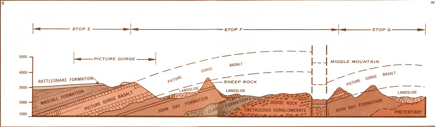
| E. 126.0 | Picture Gorge. Visible to the left of Picture Gorge, from north around to west, in order of their deposition and geologic age from oldest to youngest, are the Picture Gorge Basalt, Mascall Formation, and Rattlesnake Formation (Fig. 5). The Picture Gorge Basalt flows and ashy beds of the Mascall Formation were tilted southward together and eroded before the Rattlesnake Formation was laid down horizontally across them. Picture Gorge and the present valley were then cut by the John Day River after the Rattlesnake Formation had been tilted in its turn. The five benches or terraces on the basalt just east of Picture Gorge mark temporary halts in downcutting of the John Day River. | ||
| |||
| F. 122.0 |
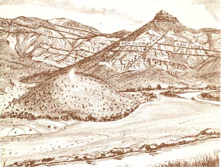
Thomas Condon Viewpoint, John Day Fossil Beds State Park (now National Monument). From Picture Gorge to the cliffs opposite, the Picture Gorge Basalts and varicolored ash beds of the John Day Formation rise together nearly 2000 feet. The basalt that caps Sheep Rock is an erosional remnant. The lower beds in the John Day Formation are colored red by clay eroded from thick soil on the Clarno Formation, which is exposed in the farthest red hill. The soil was formed by tropical weathering some 30-35 million years ago, before the John Day Formation was laid down. Faulting on a small scale is illustrated in Sheep Rock, where the thick olive-drab ash flow in the middle of the John Day Formation is offset 75-100 feet (Fig. 6). The fault slopes about 45° eastward. About two miles down stream, large-scale movement on two faults has dropped the basalt flows in Middle Mountain 2000-2500 feet. One of the faults follows along the upstream base of Middle Mountain (Fig. 6). | ||
| |||
| G. 118.7 |
Munro (now Blue Basin) Area, John Day Fossil Beds State Park (now National Monument). The valley of the John Day River has been widened to nearly five miles by erosion in the John Day Formation. Large tilted slide blocks of the John Day Formation and basalts jumbled together show how important landsliding of soft beds under hard rocks can be in widening valleys. Here one can appreciate the regularity and extent of basalt flows of the flood or plateau type, which form the Columbia Plateau. Individual flows have been traced 100 miles. Travelers will see few other rocks between here and The Dalles, Wenatchee, Pendleton, or Spokane as they cross parts of the Columbia Plateau. | ||
| H. 116.2 |
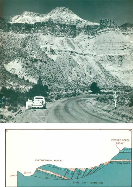
Cathedral Rock. The bluff called Cathedral Rock is the front face of a large block of the John Day Formation that has slid from the west (Fig. 7). Inside the next horseshoe bend downstream a large mass of basalt is tilted down against Cathedral Rock. From the highway 1.1 miles farther north one can see the side of the tilted block along the river, and the same two prominent red and olive-drab ash layers in the high bluff from which the block slid. The horseshoe bend was formed as the river was pushed eastward by the nose of the landslide. | ||
| |||
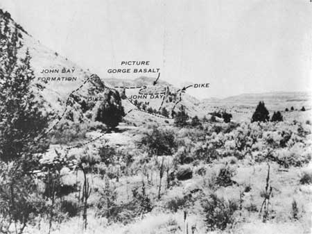
| J. 107.0 | Kimberly Dike. The low bluff across the river is formed by a vertical dike of basalt which is about 60 feet wide. This dike cuts through the John Day Formation and, farther north, the Picture Gorge Basalt (Fig. 8). It crosses the river valley diagonally and can be traced nearly four miles. The dike is formed of once-molten rock that "froze" in a fissure which was a channelway for lava that fed a flow on the earth's surface. Many similar dikes are visible along the road east of Kimberly. The basaltic magma is believed to have originated at depths of 40 miles or more within the part of the earth called the mantle. (At 105.3 turn east on State Highway 402 along the North Fork of the John Day River) | ||
| |||
| <<< Previous | <<< Contents >>> | Next >>> |
inf/john_day/sec3a.htm
Last Updated: 28-Mar-2006